
Ourimbah, New South Wales
Encyclopedia
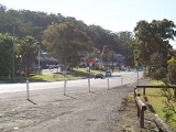
Ourimbah is a small township and a suburb of the Central Coast region of New South Wales
, Australia
, located about 78 kilometres (48 mi) north of the Sydney CBD. The township today consists of small scattered local shops and businesses along the Pacific Highway, as well as the Central Coast campus of the University of Newcastle
.
There are many sites around Ourimbah which provide evidence of Aboriginal occupation. These include axe grinding grooves, archaeological deposits of campfires and food scraps, cave art, as well as many stone implements which have been purloined by museums and privateers.
Blue Gum Flat Public School (Ourimbah Public School) was built in 1863 on the site of the present railway station. In 1886 the school was moved to the opposite side of the road and a wooden building constructed. The Ourimbah railway station
was built in the same year and opened on 15 August 1887 and was the only station other than Narara
between Gosford and Wyong at this time.
The relocation of the school and construction of the railway provided the opportunity for the subdivision of land into "town-size" allotments and the creation at Ourimbah of a townscape at first dubbed "Beckford". An area had previously been earmarked for a township to the north of this planned subdivision.
The town of Ourimbah, with its blue gums, blackbutts, round leaved gum, spotted gum and white mahogany trees, was an ideal place for the milling of timber to support a Sydney building boom between 1840 and 1870. The 1840s saw a major growth of population in the Ourimbah area. Attracted by the availability of work cutting timber, a great number of young couples moved all through the Central Coast, gradually forming settlements at which many began to put down roots.
While the timber supply thinned out, other means such as Citrus fruit and dairy farming restored the fortunes of Ourimbah. Later, in the 1950s it was realised that the dairy industry could not survive. The citrus farmers found themselves in a similar bind, unable to match the economies of scale available to producers elsewhere.
In January 1970, Ourimbah was the venue for Australia's first major rock festival drawing 11,000 fans.
The early 1970s land boom, which saw much land redeveloped into smaller holdings, was the end of any serious potential for farming as a means of supporting a family in Ourimbah. Land use once again changed, with pockets of urban development amongst the acreages, themselves now valuable for the leisure opportunities they offered rather than as agricultural holdings.
 Ourimbah Public School is the oldest school on the Central Coast, opening in 1863 as Blue Gum Flat School. It continues to grow and change from its once small stable rural environment to its present rapidly expanding urban environment.
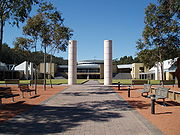
The University of Newcastle
has a major presence on the Central Coast at Ourimbah through a multi-sector co-located partnership of the University and TAFE NSW - Hunter Institute. "Ourimbah" is an Indigenous word expressing a place of learning, and the campus is located on traditional lands where this learning took place. The Ourimbah campus offers University, TAFE and Community College programs and courses on one site so that students can take advantage of pathways between levels and sectors of education and training. Affiliates are the Central Coast Community College and the Central Coast Conservatorium of Music. The University of Newcastle commenced teaching at the Ourimbah Campus, also known as the Central Coast Campus, in 1989.
Campus Central is the Ourimbah Campus student association. Campus Central has been operating as an independent student organisation at the Ourimbah Cmapus since 1994. Campus Central has retained autonomy through the VSU (Voluntary Student Unionism
) legislation changes and continutes to provide services to students, members and the Campus community.
More information and photos can be found at:
http://www.wyongsc.nsw.gov.au/environment/heritage_inventory.html
http://www.wyongsc.nsw.gov.au/wyongshire/historical_sites.html
, the "F3" Sydney-Newcastle Freeway
, and the Pacific Highway
which runs through its centre. It is part of the Wyong Shire local government area
.
Ourimbah is a rapidly-developing residential area, with major upgrades to the main road occurring as of 2007 by the Roads and Traffic Authority
.
Upgrading the intersection of the Pacific Highway and Dog Trap Road at Ourimbah:
Upgrading the Pacific Highway between Glen Road and Burns Road:
New South Wales
New South Wales is a state of :Australia, located in the east of the country. It is bordered by Queensland, Victoria and South Australia to the north, south and west respectively. To the east, the state is bordered by the Tasman Sea, which forms part of the Pacific Ocean. New South Wales...
, Australia
Australia
Australia , officially the Commonwealth of Australia, is a country in the Southern Hemisphere comprising the mainland of the Australian continent, the island of Tasmania, and numerous smaller islands in the Indian and Pacific Oceans. It is the world's sixth-largest country by total area...
, located about 78 kilometres (48 mi) north of the Sydney CBD. The township today consists of small scattered local shops and businesses along the Pacific Highway, as well as the Central Coast campus of the University of Newcastle
University of Newcastle, Australia
The University of Newcastle is an Australian public university that was established in 1965. The University's main and largest campus is located in Callaghan, a suburb of Newcastle in New South Wales...
.
History
The Aboriginal word “Oorin” meaning “Belt of manhood” in which a stone axe was carried on hunting expeditions, and “Oorinbah” which is the bora ring or ceremonial ground in which the initiation ceremony of conferring the “belt of manhood” was carried out is where the name for Ourimbah originates from. Ourimbah was also known as ‘Blue Gum Flats’ which is what the school was called. The name of Ourimbah was universally adopted for the School, Post Office, Railway and Township in the late 1800s.There are many sites around Ourimbah which provide evidence of Aboriginal occupation. These include axe grinding grooves, archaeological deposits of campfires and food scraps, cave art, as well as many stone implements which have been purloined by museums and privateers.
Blue Gum Flat Public School (Ourimbah Public School) was built in 1863 on the site of the present railway station. In 1886 the school was moved to the opposite side of the road and a wooden building constructed. The Ourimbah railway station
Ourimbah railway station, New South Wales
-Transport links:Busways runs two routes via Ourimbah railway station:*Route 36 - between Gosford and Tuggerah*Route 37 - between Gosford and TuggerahRedbus runs one route via Ourimbah railway station:*Route 47 - between Bay Village and Wyong-References:...
was built in the same year and opened on 15 August 1887 and was the only station other than Narara
Narara railway station, New South Wales
-Transport links:Busways runs two routes via Narara railway station:*Route 36 - between Gosford and Tuggerah*Route 37 - between Gosford and Tuggerah-See also:*Narara, New South Wales...
between Gosford and Wyong at this time.
The relocation of the school and construction of the railway provided the opportunity for the subdivision of land into "town-size" allotments and the creation at Ourimbah of a townscape at first dubbed "Beckford". An area had previously been earmarked for a township to the north of this planned subdivision.
The town of Ourimbah, with its blue gums, blackbutts, round leaved gum, spotted gum and white mahogany trees, was an ideal place for the milling of timber to support a Sydney building boom between 1840 and 1870. The 1840s saw a major growth of population in the Ourimbah area. Attracted by the availability of work cutting timber, a great number of young couples moved all through the Central Coast, gradually forming settlements at which many began to put down roots.
While the timber supply thinned out, other means such as Citrus fruit and dairy farming restored the fortunes of Ourimbah. Later, in the 1950s it was realised that the dairy industry could not survive. The citrus farmers found themselves in a similar bind, unable to match the economies of scale available to producers elsewhere.
In January 1970, Ourimbah was the venue for Australia's first major rock festival drawing 11,000 fans.
The early 1970s land boom, which saw much land redeveloped into smaller holdings, was the end of any serious potential for farming as a means of supporting a family in Ourimbah. Land use once again changed, with pockets of urban development amongst the acreages, themselves now valuable for the leisure opportunities they offered rather than as agricultural holdings.
Education
The University of Newcastle
University of Newcastle, Australia
The University of Newcastle is an Australian public university that was established in 1965. The University's main and largest campus is located in Callaghan, a suburb of Newcastle in New South Wales...
has a major presence on the Central Coast at Ourimbah through a multi-sector co-located partnership of the University and TAFE NSW - Hunter Institute. "Ourimbah" is an Indigenous word expressing a place of learning, and the campus is located on traditional lands where this learning took place. The Ourimbah campus offers University, TAFE and Community College programs and courses on one site so that students can take advantage of pathways between levels and sectors of education and training. Affiliates are the Central Coast Community College and the Central Coast Conservatorium of Music. The University of Newcastle commenced teaching at the Ourimbah Campus, also known as the Central Coast Campus, in 1989.
Campus Central is the Ourimbah Campus student association. Campus Central has been operating as an independent student organisation at the Ourimbah Cmapus since 1994. Campus Central has retained autonomy through the VSU (Voluntary Student Unionism
Voluntary student unionism
Voluntary student unionism is a policy, notable in Australia, under which membership of – and payment of membership fees to – university student organisations is voluntary....
) legislation changes and continutes to provide services to students, members and the Campus community.
Historical sites and heritage listed buildings
- Sawmill (R. Brownlee & Co.) - Brownlee Street
- Utility Structure – No. 1A Jaques Street
- Dwelling – No. 23 Chittaway Road
- Dwelling (Former Post Office) - Ourimbah Creek Road
- Primary School – No. 121 Pacific Highway
- Railway Station - Pacific Highway
- Shop – No. 21 Pacific Highway
- World War 1 Monument - Pacific Highway
- Post Office and Residence - Station Street
- Dwelling – No. 100 Shirley Street
More information and photos can be found at:
http://www.wyongsc.nsw.gov.au/environment/heritage_inventory.html
http://www.wyongsc.nsw.gov.au/wyongshire/historical_sites.html
Transport
Ourimbah lies on the Sydney-Newcastle railway lineMain North railway line, New South Wales
The Main North Line is a major railway in New South Wales, Australia. It runs through the Central Coast, Hunter and the New England regions. The line was the original main line between Sydney and Brisbane, however this required a change of gauge at Wallangarra...
, the "F3" Sydney-Newcastle Freeway
Sydney-Newcastle Freeway
The Sydney-Newcastle Freeway is a stretch of motorway linking Sydney to the Central Coast, Newcastle and Hunter regions of New South Wales. It is part of the AusLink road corridor between Sydney and Brisbane, carrying the route designation....
, and the Pacific Highway
Pacific Highway (Australia)
The Pacific Highway is a major transport route along part of the east coast of Australia and is part of Australia's national route 1.It is 960 km long and links Sydney, the capital of New South Wales, to Brisbane, the capital of Queensland, along the coast, via Gosford, Newcastle, Taree, Port...
which runs through its centre. It is part of the Wyong Shire local government area
Local Government Areas of New South Wales
The local government areas of New South Wales, Australia have been subject to periodic bouts of restructuring and rationalisation by the State Government, involving voluntary and involuntary amalgamation of areas...
.
Ourimbah is a rapidly-developing residential area, with major upgrades to the main road occurring as of 2007 by the Roads and Traffic Authority
Roads and Traffic Authority
The Roads and Traffic Authority is a former New South Wales government agency that was responsible for major road infrastructure, licensing of drivers, and registration of motor vehicles. The RTA directly managed State roads and provided funding to local councils for regional and local roads...
.
- Stage 1 - Lisarow to Ourimbah
Upgrading the intersection of the Pacific Highway and Dog Trap Road at Ourimbah:
- Stage 2 - Lisarow to Ourimbah
Upgrading the Pacific Highway between Glen Road and Burns Road:
- Stage 3 - Lisarow to Ourimbah
Historical images
- Looking South at Ourimbah, 1910: http://www.users.bigpond.com/narrabeen/ourimbah/images/K_Town.JPG
- Ourimbah Public School, 1910: http://www.users.bigpond.com/narrabeen/ourimbah/images/K_School.JPG
- Peach Orchard Road, Ourimbah, 1912: http://www.gosford.nsw.gov.au/library/local_history/images/atrium30.jpg
- Ourimbah Sawmill, 1902: http://www.gosford.nsw.gov.au/library/local_history/images/atrium29a.jpg
- Ourimbah Public School, 1910: http://image.sl.nsw.gov.au/Ebind/pxa635/a106_129-131/a106130r.jpg
- Burns Store, 1915: http://image.sl.nsw.gov.au/Ebind/pxa635/a106_129-131/a106131r.jpg
- Illustration of formed roads in and about Ourimbah, 1920: http://www.users.bigpond.com/narrabeen/ourimbah/images/Ourimbah%20c1920.jpg
Further reading
- ‘Ourimbah Recollections’ Historical anecdotes of Ourimbah 1829 to 1994. ISBN 0-646-21049-1 Published by Ourimbah Public School
External links
- An account of the Ourimbah "Pilgrimage For Pop": http://www.milesago.com/Festivals/ourimbah.htm
- Old subdivision maps: http://www.gosford.nsw.gov.au/library/local_history/subdivision/ourimbah.html
- Brisbane Water History Mural: http://www.gosford.nsw.gov.au/library/local_history/documents/brisbane-water-history-mural-the-atrium-food-court-erina-fair