
Ostrander Lake
Encyclopedia
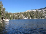
Ostrander Lake is located in Yosemite National Park
, approximately 10 miles (16.1 km) south of Yosemite Valley
and 10 miles (16.1 km) east of the Badger Pass Ski Area, at an elevation of 8500 feet (2,590.8 m). The lake is a popular destination for cross-country skiers
during the winter. It is the primary source of Bridalveil Creek, which feeds Bridalveil Falls
.
on the Glacier Point
road. The hike begins with a fairly level path through an extensive burned over and regrowth area, with both shaded and sunny areas. The second half of the hike climbs, steeply at times, over 1500 feet (457.2 m) in elevation in about 3 miles. Hikers will have a nice view of Clark Range
before dropping down to the north shore of the lake. Several excellent campsites can be found on the west side of the lake, particularly on the benches overlooking the rocky ridge that forms the eastern shore backdrop. Fishing is fair for 10-12" rainbow trout. In the summer, the lake is a great backpacking destination because the ski hut is unoccupied but its presence keeps away the hordes of hikers looking for a "wilderness" destination.
The lake is named for a descendant of Alexander Ostrander (1783) of Smithfield NY. This branch of Ostrander family settled in Colorado (Georgetown, Granby, Hot Sulphur Springs, Golden) prior to 1872, and some moved from Colorado to California.
 The Ostrander Ski Hut is a two story stone structure built in 1941 by the Civilian Conservation Corps
specifically for cross-country skiers. The hut sits in a small glacial cirque at the edge of Ostrander Lake. Very basic overnight accommodations and cooking facilities are available at the hut. It sleeps 25 people and has bunks, mattresses, wood stove, a kitchen with a gas stove for cooking and assorted pots and pans available for the visitor's use. Drinking and wash water is hauled from the lake in buckets; treatment is the individual visitor's responsibility. Light is from solar powered lights.
In winter, when the Glacier Point Road is closed at Badger Pass Ski area, the trail to Ostrander Ski Hut is ten miles one way. The trip is not for novices.
The Ostrander Ski Hut is operated by the Yosemite Conservancy, a non-profit educational organization in Yosemite National Park.
Yosemite National Park
Yosemite National Park is a United States National Park spanning eastern portions of Tuolumne, Mariposa and Madera counties in east central California, United States. The park covers an area of and reaches across the western slopes of the Sierra Nevada mountain chain...
, approximately 10 miles (16.1 km) south of Yosemite Valley
Yosemite Valley
Yosemite Valley is a glacial valley in Yosemite National Park in the western Sierra Nevada mountains of California, carved out by the Merced River. The valley is about long and up to a mile deep, surrounded by high granite summits such as Half Dome and El Capitan, and densely forested with pines...
and 10 miles (16.1 km) east of the Badger Pass Ski Area, at an elevation of 8500 feet (2,590.8 m). The lake is a popular destination for cross-country skiers
Cross-country skiing
Cross-country skiing is a winter sport in which participants propel themselves across snow-covered terrain using skis and poles...
during the winter. It is the primary source of Bridalveil Creek, which feeds Bridalveil Falls
Bridalveil Fall (Yosemite)
Bridalveil Fall is one of the most prominent waterfalls in the Yosemite Valley in California, seen yearly by millions of visitors to Yosemite National Park....
.
Hiking Trail
The hike to Ostrander Lake is a long and strenuous 12.7 miles (20.4 km) roundtrip hike starting from the trailhead located just after Bridalveil CreekBridalveil Creek
thumb|300px|right| Hanging valley of Bridalveil Creek, showing its pronounced form which is controlled, in large measure, by sparse diagonal joint structures....
on the Glacier Point
Glacier Point
thumb|right|upright|Glacier Point, as seen from [[Yosemite Valley]]. In springtime, this cliff face is covered with dozens of freshets and tiny waterfalls from the snowmelt, the largest being [[Staircase Falls]]....
road. The hike begins with a fairly level path through an extensive burned over and regrowth area, with both shaded and sunny areas. The second half of the hike climbs, steeply at times, over 1500 feet (457.2 m) in elevation in about 3 miles. Hikers will have a nice view of Clark Range
Clark Range (California)
The Clark Range is a subrange of California's Sierra Nevada in Yosemite National Park.-Geography:The range extends in a north-south direction from Quarzite Peak to Triple Divide Peak and separates the drainage basins of the Illilouette Creek from the uppermost portions of the Merced River...
before dropping down to the north shore of the lake. Several excellent campsites can be found on the west side of the lake, particularly on the benches overlooking the rocky ridge that forms the eastern shore backdrop. Fishing is fair for 10-12" rainbow trout. In the summer, the lake is a great backpacking destination because the ski hut is unoccupied but its presence keeps away the hordes of hikers looking for a "wilderness" destination.
The lake is named for a descendant of Alexander Ostrander (1783) of Smithfield NY. This branch of Ostrander family settled in Colorado (Georgetown, Granby, Hot Sulphur Springs, Golden) prior to 1872, and some moved from Colorado to California.
The Ostrander Ski Hut
Civilian Conservation Corps
The Civilian Conservation Corps was a public work relief program that operated from 1933 to 1942 in the United States for unemployed, unmarried men from relief families, ages 18–25. A part of the New Deal of President Franklin D...
specifically for cross-country skiers. The hut sits in a small glacial cirque at the edge of Ostrander Lake. Very basic overnight accommodations and cooking facilities are available at the hut. It sleeps 25 people and has bunks, mattresses, wood stove, a kitchen with a gas stove for cooking and assorted pots and pans available for the visitor's use. Drinking and wash water is hauled from the lake in buckets; treatment is the individual visitor's responsibility. Light is from solar powered lights.
In winter, when the Glacier Point Road is closed at Badger Pass Ski area, the trail to Ostrander Ski Hut is ten miles one way. The trip is not for novices.
The Ostrander Ski Hut is operated by the Yosemite Conservancy, a non-profit educational organization in Yosemite National Park.