

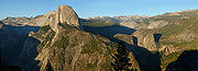
Glacier Point
Encyclopedia

Cliff
In geography and geology, a cliff is a significant vertical, or near vertical, rock exposure. Cliffs are formed as erosion landforms due to the processes of erosion and weathering that produce them. Cliffs are common on coasts, in mountainous areas, escarpments and along rivers. Cliffs are usually...
above Yosemite Valley
Yosemite Valley
Yosemite Valley is a glacial valley in Yosemite National Park in the western Sierra Nevada mountains of California, carved out by the Merced River. The valley is about long and up to a mile deep, surrounded by high granite summits such as Half Dome and El Capitan, and densely forested with pines...
, in California
California
California is a state located on the West Coast of the United States. It is by far the most populous U.S. state, and the third-largest by land area...
, USA. It is located on the south wall of Yosemite Valley at an elevation of 7214 feet (2,198.8 m), 3200 feet (975.4 m) above Curry Village. The point offers a superb view of Yosemite National Park
Yosemite National Park
Yosemite National Park is a United States National Park spanning eastern portions of Tuolumne, Mariposa and Madera counties in east central California, United States. The park covers an area of and reaches across the western slopes of the Sierra Nevada mountain chain...
's Yosemite Valley, including Yosemite Falls
Yosemite Falls
Yosemite Falls is the highest measured waterfall in North America. Located in Yosemite National Park in the Sierra Nevada of California, it is a major attraction in the park, especially in late spring when the water flow is at its peak....
, Half Dome
Half Dome
Half Dome is a granite dome in Yosemite National Park, located in northeastern Mariposa County, California, at the eastern end of Yosemite Valley — possibly Yosemite's most familiar rock formation. The granite crest rises more than above the valley floor....
, Vernal Fall, Nevada Fall
Nevada Fall
Nevada Fall is a high waterfall on the Merced River in Yosemite National Park, California. It is located below the granite dome, Liberty Cap, at the west end of Little Yosemite Valley. The waterfall is widely recognized by its "bent" shape, in which the water free-falls for roughly the first third...
, and Clouds Rest
Clouds Rest
Clouds Rest is a mountain in Yosemite National Park east northeast of Yosemite Village, California. Although there are many peaks in the park having far greater elevation, Clouds Rest's proximity to the valley gives it a very high degree of visual prominence....
.
Geology
The extreme point of the promontory of Glacier Point is wholly bare, but on the slopes below, in the hollow to the west, and on the wooded slope above, glacial material is abundant. Its glacial origin is definitely proved by the presence in it of rocks derived from Little Yosemite ValleyLittle Yosemite Valley
Little Yosemite Valley is, as the name implies, a smaller glacial valley upstream in the Merced River drainage from the Yosemite Valley in Yosemite National Park. The Merced River meanders through the long flat valley, draining out over Nevada Fall and Vernal Fall before emptying into the main...
and the High Sierra
There are three types of glacially-deposited rock at Glacier Point:
- Most plentiful are rounded boulders and cobbles and angular fragments, all deeply weathered, of Half Dome quartz monzonite, the light-colored granite of which not only Half DomeHalf DomeHalf Dome is a granite dome in Yosemite National Park, located in northeastern Mariposa County, California, at the eastern end of Yosemite Valley — possibly Yosemite's most familiar rock formation. The granite crest rises more than above the valley floor....
, but all of the Little Yosemite and its surrounding heights are composed. - There are also a few boulders of a coarse-grained, highly siliceous granite, light buff in general tone when fresh but vivid rose when weathered. There is only one place in the High Sierra above the Yosemite from which they can be derived: Mount Clark, the sharp-profiled peak which stands on the east side of the Illilouette Basin, 8 miles (12.9 km) from Glacier Point.
- Finally, there are fragments of yellowish quartzite and gray schist whose places of origin have been located on the long northern spur of Mount Clark.
Glacier Point can be reached from the Valley via Glacier Point Road. During the summer, Glacier Point is often crowded with tourists. Tours by bus are also available and take about four hours. The road is usually open from June through October. In winter, Glacier Point Road closes due to snow, and access to Glacier Point from the Badger Pass Ski Area
Badger Pass Ski Area
Badger Pass Ski Area is a small ski area located within Yosemite National Park. Badger Pass is one of only three lift serviced ski areas operating in a US National Park...
is only by ski
Cross-country skiing
Cross-country skiing is a winter sport in which participants propel themselves across snow-covered terrain using skis and poles...
or snowshoe
Snowshoe
A snowshoe is footwear for walking over the snow. Snowshoes work by distributing the weight of the person over a larger area so that the person's foot does not sink completely into the snow, a quality called "flotation"....
.
Glacier Point can also be reached via the Four Mile Trail
Four Mile Trail
Four Mile Trail is a moderate to strenuous trail leading from Yosemite Valley to Glacier Point. The trail begins at the valley floor west of the Swinging Bridge recreation area, and climbs the south side up to Glacier Point, an elevation change of ....
, which ascends the 3200 feet (975.4 m) in 4.6 miles (7.4 km). This moderate to strenuous trail can provide access to Glacier Point when the Glacier Point Road is closed. Note, however, that the trail can be extremely hazardous when covered with snow or ice, so is usually closed by the Park Service from December through May. Another 8.2 miles (13.2 km) trail runs from Glacier Point down to the Valley, via the Panorama Trail, past Nevada and Vernal Falls.
See also
- Yosemite FirefallYosemite FirefallThe Yosemite Firefall was a summer time ritual that lasted from 1872 until 1968 in which burning hot embers were dropped a height of about 3000 feet from the top of Glacier Point in Yosemite National Park down to the valley below, and from a distance looked similar to a glowing water fall because...
- Yosemite ValleyYosemite ValleyYosemite Valley is a glacial valley in Yosemite National Park in the western Sierra Nevada mountains of California, carved out by the Merced River. The valley is about long and up to a mile deep, surrounded by high granite summits such as Half Dome and El Capitan, and densely forested with pines...
- Yosemite National ParkYosemite National ParkYosemite National Park is a United States National Park spanning eastern portions of Tuolumne, Mariposa and Madera counties in east central California, United States. The park covers an area of and reaches across the western slopes of the Sierra Nevada mountain chain...
- Four Mile TrailFour Mile TrailFour Mile Trail is a moderate to strenuous trail leading from Yosemite Valley to Glacier Point. The trail begins at the valley floor west of the Swinging Bridge recreation area, and climbs the south side up to Glacier Point, an elevation change of ....