

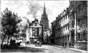
Oriel Street
Encyclopedia
High Street, Oxford
The High Street in Oxford, England runs between Carfax, generally recognized as the centre of the city, and Magdalen Bridge to the east. Locally the street is often known as The High. It forms a gentle curve and is the subject of many prints, paintings, photographs, etc...
to the north and Oriel Square
Oriel Square
Oriel Square, formerly known as Canterbury Square is a square in central Oxford, England, located south of the High Street. The name was changed after the Second World War at the request of Oriel College which maintained that the square had originally been known as Oriel Square.To the east at the...
to the south in central Oxford
Oxford
The city of Oxford is the county town of Oxfordshire, England. The city, made prominent by its medieval university, has a population of just under 165,000, with 153,900 living within the district boundary. It lies about 50 miles north-west of London. The rivers Cherwell and Thames run through...
, England
England
England is a country that is part of the United Kingdom. It shares land borders with Scotland to the north and Wales to the west; the Irish Sea is to the north west, the Celtic Sea to the south west, with the North Sea to the east and the English Channel to the south separating it from continental...
. The street is now blocked off to traffic by bollards at the High Street end.
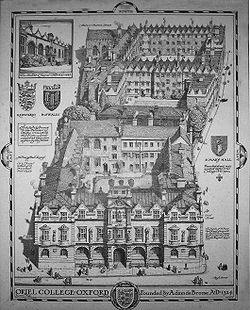
It passes between the main site of Oriel College (hence its name) to the east and Oriel's newer "Island" site to the west. At the High Street end to the east is the 1911 Rhodes Building, named after the former Oriel student Cecil Rhodes
Cecil John Rhodes
Cecil John Rhodes PC, DCL was an English-born South African businessman, mining magnate, and politician. He was the founder of the diamond company De Beers, which today markets 40% of the world's rough diamonds and at one time marketed 90%...
, who went on to colonize the Africa
Africa
Africa is the world's second largest and second most populous continent, after Asia. At about 30.2 million km² including adjacent islands, it covers 6% of the Earth's total surface area and 20.4% of the total land area...
n state of Rhodesia
Rhodesia
Rhodesia , officially the Republic of Rhodesia from 1970, was an unrecognised state located in southern Africa that existed between 1965 and 1979 following its Unilateral Declaration of Independence from the United Kingdom on 11 November 1965...
(also named after him).
History
The name Oriel Street was in use by 1850; from 1210 it was called Schidyard Street although the spelling changed over time, according to Thomas HearneThomas Hearne
Thomas Hearne or Hearn , English antiquary, was born at Littlefield Green in the parish of White Waltham, Berkshire.-Life:...
in 1728 it was Sched Row — Writers' Row, and between 1542 and 1772 it was known as St Mary Hall Lane. A map of 1814 shows the street running south through what is now Corpus Christi
Corpus Christi College, Oxford
Corpus Christi College is one of the constituent colleges of the University of Oxford in the United Kingdom...
as far the President's lodgings. Until 1838, it was also known as Skimmery Hall Lane and Oriel Lane was in use from around the mid-19th century.
In 1833, the first of a number of theatres in Oxford to be known as "The New Theatre" was opened in St Mary Hall Lane. It is generally thought that this refers to the Oriel Square tennis court
Oriel Square tennis court
In Oriel Square, Oxford, England, the remains of a real tennis court can be recognised. The Liber Albus mentions the Oriel court being in Vinehall Lane in 1577...
. In August 1986, a tunnel under the street, connecting St Mary quad and O'Brien quad, was completed.