

Ord River Floodplain
Encyclopedia
The Ord River floodplain is the floodplain
of the lower Ord River
in the Shire of Wyndham-East Kimberley, in the Kimberley region of northern Western Australia
. It lies within the Victoria Bonaparte
IBRA
bioregion
and contains river, seasonal creek, tidal mudflat
and floodplain wetlands, with extensive stands of mangrove
s, that support Saltwater Crocodile
s and many waterbirds. It is recognised as an internationally important wetland
area, with 1,384 km2 of it designated on 7 June 1990 as Ramsar Site 477 under the Ramsar Convention on Wetlands
.
.jpg)
_i2_img_4282.jpg)
, extending from 14°51′S 128°12′E to 15°46′S 128°33′E. It comprises the Ord River and Parry Lagoons nature reserve
s, with some additional land. It lies downstream of two large impoundments
on the Ord River, Lakes Argyle
and Kununurra
, which have had a major impact on the river’s hydrology through changing its flow pattern so that there are now constant flows through the dry season
. In effect, the lower Ord has been transformed through flow regulation at the dam
s from a ‘dry tropics’ to a ‘wet tropics’ river.
The southern part of the site is dominated by Parry Creek, including 20 km of seasonal creek and an alluvial floodplain which is flooded during the wet season
. It dries out quickly in the dry season
, except for waterholes associated with incised channels and claypan
s. The southern, or upstream, part of the floodplain is freshwater, while the northern, or downstream part, is either regularly flooded with saltwater
or contains saline soils.
The lower reaches of the Ord River extend from the Parry Creek floodplain northwards to the Cambridge Gulf
. The upper reaches of the Ord River are permanently fresh; the lower reaches, when not in flood, become saline due to the tidal cycle
which, at the coast, has an amplitude
of up to 8 m. Within the site the upstream end of the river channel is around 150 m wide with broad sand
and gravel
spits
, while unstable mud
bars
and islands characterise the 5 km wide mouth. From the mouth of the Ord River, the site extends northwards around the coast to include the False Mouths of the Ord, consisting of a maze of deltaic channels, intertidal
mudflat
s and low muddy islands, an area which receives only a little fresh water from small and ephemeral creeks.
al, with the hot and humid wet season
occurring from November to March. Wyndham has an average annual rainfall of 695 mm. The dry season is mild, with periods of steady south-easterly winds. The average maximum temperature varies from 30°C in July to 39°C in December.
s, mangroves, dune
systems, grassland
, low woodland
, sandstone range open woodland, riverine woodland, rainforest
(aquifer
forest) and spring
vegetation, major rivers and lagoons (permanent and ephemeral), and savanna
woodland. Some 335 native vascular plants from 89 families have been recorded from the site, with 16 introduced species.
The eastern coast of the Cambridge Gulf is one of the richest places for mangroves in the Kimberley region in terms of species diversity, structural complexity, and area, with 14 species occurring within the site. Zonation is evident; mangrove species in the seaward zone form a woodland about 8 m high, dominated by Sonneratia alba, Avicennia marina
and Aegiceras corniculatum
. Behind this, in a woodland 10 m high, are Bruguiera parviflora, Avicennia marina and Aegiceras corniculatum, and then a belt of Rhizophora stylosa 12 15 m high. On the landward edge is a 4 m high thicket of Avicennia marina, Ceriops tagal and Aegialitis annulata. Sporobolus virginicus
grassland and samphire grow on the mudflats behind the mangroves. Other occasional species of mangrove include Xylocarpus moluccensis, Excoecaria agallocha and Camptostemon schultzii.
species include Hardhead
, Grey Teal
and Plumed Whistling Duck
. The lagoons are also an important site for shorebirds
: several thousand Little Curlew
s and Oriental Pratincole
s, and hundreds of Wood Sandpiper
s have been counted. The Parry Lagoons are probably the most important site in Australia for both Wood and Marsh Sandpiper
s. When local rainfall is high the lagoons and other seasonal wetlands are major breeding areas for waterbirds in the Kimberley, with up to 77 species recorded in habitats associated with Parry Creek. The grasslands are the only place in Western Australia where Zitting Cisticola
s occur naturally. The mangroves contain 12 of the 13 species of terrestrial bird restricted to such habitat, or to rainforest, in Western Australia, including the Black Butcherbird
. About 200 bird species have been recorded from the site.
, the Black Flying-fox
and Grassland Melomys. Other mammals known from the site include: the Northern Nail-tail Wallaby
, Agile Wallaby
, Long-haired Rat
and Kimberley Rock Rat. The critically endangered
Largetooth Sawfish
has been collected from the lower Ord River.
have a complex and spiritual relationship with the land and waters of the Ord River. The site lies within the traditional lands of the Miriuwung
and Gajerrong
language groups, and there are many cultural heritage sites, including those concerned with ceremonial, mythological and burial activities, associated with the river.
The area is a regular tourist
destination. Some exploration for alluvial diamond
s takes place. The surrounding land is used for cattle grazing
.
Floodplain
A floodplain, or flood plain, is a flat or nearly flat land adjacent a stream or river that stretches from the banks of its channel to the base of the enclosing valley walls and experiences flooding during periods of high discharge...
of the lower Ord River
Ord River
The Ord River is a 320-kilometre-long river in the Kimberley region of Western Australia. It was named in honour of Harry Ord, Governor of Western Australia from 1877 to 1880....
in the Shire of Wyndham-East Kimberley, in the Kimberley region of northern Western Australia
Western Australia
Western Australia is a state of Australia, occupying the entire western third of the Australian continent. It is bounded by the Indian Ocean to the north and west, the Great Australian Bight and Indian Ocean to the south, the Northern Territory to the north-east and South Australia to the south-east...
. It lies within the Victoria Bonaparte
Victoria Bonaparte
Victoria Bonaparte is an Interim Biogeographic Regionalisation for Australia region in the Northern Territory and Western Australia.-Further reading:...
IBRA
Interim Biogeographic Regionalisation for Australia
The Interim Biogeographic Regionalisation for Australia is a biogeographic regionalisation of Australia developed by the Australian Government's Department of the Environment, Water, Heritage and the Arts...
bioregion
Ecoregion
An ecoregion , sometimes called a bioregion, is an ecologically and geographically defined area that is smaller than an ecozone and larger than an ecosystem. Ecoregions cover relatively large areas of land or water, and contain characteristic, geographically distinct assemblages of natural...
and contains river, seasonal creek, tidal mudflat
Mudflat
Mudflats or mud flats, also known as tidal flats, are coastal wetlands that form when mud is deposited by tides or rivers. They are found in sheltered areas such as bays, bayous, lagoons, and estuaries. Mudflats may be viewed geologically as exposed layers of bay mud, resulting from deposition of...
and floodplain wetlands, with extensive stands of mangrove
Mangrove
Mangroves are various kinds of trees up to medium height and shrubs that grow in saline coastal sediment habitats in the tropics and subtropics – mainly between latitudes N and S...
s, that support Saltwater Crocodile
Saltwater Crocodile
The saltwater crocodile, also known as estuarine or Indo-Pacific crocodile, is the largest of all living reptiles...
s and many waterbirds. It is recognised as an internationally important wetland
Wetland
A wetland is an area of land whose soil is saturated with water either permanently or seasonally. Wetlands are categorised by their characteristic vegetation, which is adapted to these unique soil conditions....
area, with 1,384 km2 of it designated on 7 June 1990 as Ramsar Site 477 under the Ramsar Convention on Wetlands
Ramsar Convention
The Ramsar Convention is an international treaty for the conservation and sustainable utilization of wetlands, i.e., to stem the progressive encroachment on and loss of wetlands now and in the future, recognizing the fundamental ecological functions of wetlands and their economic, cultural,...
.
Description
The site lies about 8 km east of the town of WyndhamWyndham, Western Australia
Wyndham is the oldest and northernmost town in the Kimberley region of Western Australia, located on the Great Northern Highway, northeast of Perth. It was established in 1885 as a result of a gold rush at Halls Creek, and it is now a port and service centre for the east Kimberley with a...
, extending from 14°51′S 128°12′E to 15°46′S 128°33′E. It comprises the Ord River and Parry Lagoons nature reserve
Nature reserve
A nature reserve is a protected area of importance for wildlife, flora, fauna or features of geological or other special interest, which is reserved and managed for conservation and to provide special opportunities for study or research...
s, with some additional land. It lies downstream of two large impoundments
Reservoir
A reservoir , artificial lake or dam is used to store water.Reservoirs may be created in river valleys by the construction of a dam or may be built by excavation in the ground or by conventional construction techniques such as brickwork or cast concrete.The term reservoir may also be used to...
on the Ord River, Lakes Argyle
Lake Argyle
Lake Argyle is Australia's second largest artificial lake by volume. It is part of the Ord River Irrigation Scheme and is located near the East Kimberley town of Kununurra...
and Kununurra
Lake Kununurra
Lake Kununurra is a long linear lake in the Ord River valley formed in 1963 by the construction of the Ord Diversion Dam in Kununurra, northern Western Australia, which was built to supply water to the Ord River Irrigation Area. The lake stretches for upstream from the Diversion Dam at towards...
, which have had a major impact on the river’s hydrology through changing its flow pattern so that there are now constant flows through the dry season
Dry season
The dry season is a term commonly used when describing the weather in the tropics. The weather in the tropics is dominated by the tropical rain belt, which oscillates from the northern to the southern tropics over the course of the year...
. In effect, the lower Ord has been transformed through flow regulation at the dam
Dam
A dam is a barrier that impounds water or underground streams. Dams generally serve the primary purpose of retaining water, while other structures such as floodgates or levees are used to manage or prevent water flow into specific land regions. Hydropower and pumped-storage hydroelectricity are...
s from a ‘dry tropics’ to a ‘wet tropics’ river.
The southern part of the site is dominated by Parry Creek, including 20 km of seasonal creek and an alluvial floodplain which is flooded during the wet season
Wet season
The the wet season, or rainy season, is the time of year, covering one or more months, when most of the average annual rainfall in a region occurs. The term green season is also sometimes used as a euphemism by tourist authorities. Areas with wet seasons are dispersed across portions of the...
. It dries out quickly in the dry season
Dry season
The dry season is a term commonly used when describing the weather in the tropics. The weather in the tropics is dominated by the tropical rain belt, which oscillates from the northern to the southern tropics over the course of the year...
, except for waterholes associated with incised channels and claypan
Claypan
In geology, a claypan is a dense, compact, slowly permeable layer in the subsoil having a much higher clay content than the overlying material, from which it is separated by a sharply defined boundary. Claypans are usually hard when dry, and plastic and sticky when wet. They limit or slow the...
s. The southern, or upstream, part of the floodplain is freshwater, while the northern, or downstream part, is either regularly flooded with saltwater
Saline water
Saline water is a general term for water that contains a significant concentration of dissolved salts . The concentration is usually expressed in parts per million of salt....
or contains saline soils.
The lower reaches of the Ord River extend from the Parry Creek floodplain northwards to the Cambridge Gulf
Cambridge Gulf
Cambridge Gulf is a gulf on the north coast of Western Australia.Many rivers flow into the gulf including the Ord River, Pentecost River, Durack River, King River and the Forrest River.The gulf experiences two large tidal flows each day between to...
. The upper reaches of the Ord River are permanently fresh; the lower reaches, when not in flood, become saline due to the tidal cycle
Tide
Tides are the rise and fall of sea levels caused by the combined effects of the gravitational forces exerted by the moon and the sun and the rotation of the Earth....
which, at the coast, has an amplitude
Amplitude
Amplitude is the magnitude of change in the oscillating variable with each oscillation within an oscillating system. For example, sound waves in air are oscillations in atmospheric pressure and their amplitudes are proportional to the change in pressure during one oscillation...
of up to 8 m. Within the site the upstream end of the river channel is around 150 m wide with broad sand
Sand
Sand is a naturally occurring granular material composed of finely divided rock and mineral particles.The composition of sand is highly variable, depending on the local rock sources and conditions, but the most common constituent of sand in inland continental settings and non-tropical coastal...
and gravel
Gravel
Gravel is composed of unconsolidated rock fragments that have a general particle size range and include size classes from granule- to boulder-sized fragments. Gravel can be sub-categorized into granule and cobble...
spits
Spit (landform)
A spit or sandspit is a deposition landform found off coasts. At one end, spits connect to land, and extend into the sea. A spit is a type of bar or beach that develops where a re-entrant occurs, such as at cove's headlands, by the process of longshore drift...
, while unstable mud
Mud
Mud is a mixture of water and some combination of soil, silt, and clay. Ancient mud deposits harden over geological time to form sedimentary rock such as shale or mudstone . When geological deposits of mud are formed in estuaries the resultant layers are termed bay muds...
bars
Bar (river morphology)
A bar in a river is an elevated region of sediment that has been deposited by the flow. Types of bars include mid-channel bars , point bars , and mouth bars...
and islands characterise the 5 km wide mouth. From the mouth of the Ord River, the site extends northwards around the coast to include the False Mouths of the Ord, consisting of a maze of deltaic channels, intertidal
Intertidal zone
The intertidal zone is the area that is above water at low tide and under water at high tide . This area can include many different types of habitats, with many types of animals like starfish, sea urchins, and some species of coral...
mudflat
Mudflat
Mudflats or mud flats, also known as tidal flats, are coastal wetlands that form when mud is deposited by tides or rivers. They are found in sheltered areas such as bays, bayous, lagoons, and estuaries. Mudflats may be viewed geologically as exposed layers of bay mud, resulting from deposition of...
s and low muddy islands, an area which receives only a little fresh water from small and ephemeral creeks.
Climate
The site has a dry tropical climate. Rainfall is monsoonMonsoon
Monsoon is traditionally defined as a seasonal reversing wind accompanied by corresponding changes in precipitation, but is now used to describe seasonal changes in atmospheric circulation and precipitation associated with the asymmetric heating of land and sea...
al, with the hot and humid wet season
Wet season
The the wet season, or rainy season, is the time of year, covering one or more months, when most of the average annual rainfall in a region occurs. The term green season is also sometimes used as a euphemism by tourist authorities. Areas with wet seasons are dispersed across portions of the...
occurring from November to March. Wyndham has an average annual rainfall of 695 mm. The dry season is mild, with periods of steady south-easterly winds. The average maximum temperature varies from 30°C in July to 39°C in December.
Vegetation
Within the site ten main vegetation associations have been identified: mudflatMudflat
Mudflats or mud flats, also known as tidal flats, are coastal wetlands that form when mud is deposited by tides or rivers. They are found in sheltered areas such as bays, bayous, lagoons, and estuaries. Mudflats may be viewed geologically as exposed layers of bay mud, resulting from deposition of...
s, mangroves, dune
Dune
In physical geography, a dune is a hill of sand built by wind. Dunes occur in different forms and sizes, formed by interaction with the wind. Most kinds of dunes are longer on the windward side where the sand is pushed up the dune and have a shorter "slip face" in the lee of the wind...
systems, grassland
Grassland
Grasslands are areas where the vegetation is dominated by grasses and other herbaceous plants . However, sedge and rush families can also be found. Grasslands occur naturally on all continents except Antarctica...
, low woodland
Woodland
Ecologically, a woodland is a low-density forest forming open habitats with plenty of sunlight and limited shade. Woodlands may support an understory of shrubs and herbaceous plants including grasses. Woodland may form a transition to shrubland under drier conditions or during early stages of...
, sandstone range open woodland, riverine woodland, rainforest
Rainforest
Rainforests are forests characterized by high rainfall, with definitions based on a minimum normal annual rainfall of 1750-2000 mm...
(aquifer
Aquifer
An aquifer is a wet underground layer of water-bearing permeable rock or unconsolidated materials from which groundwater can be usefully extracted using a water well. The study of water flow in aquifers and the characterization of aquifers is called hydrogeology...
forest) and spring
Spring (hydrosphere)
A spring—also known as a rising or resurgence—is a component of the hydrosphere. Specifically, it is any natural situation where water flows to the surface of the earth from underground...
vegetation, major rivers and lagoons (permanent and ephemeral), and savanna
Savanna
A savanna, or savannah, is a grassland ecosystem characterized by the trees being sufficiently small or widely spaced so that the canopy does not close. The open canopy allows sufficient light to reach the ground to support an unbroken herbaceous layer consisting primarily of C4 grasses.Some...
woodland. Some 335 native vascular plants from 89 families have been recorded from the site, with 16 introduced species.
The eastern coast of the Cambridge Gulf is one of the richest places for mangroves in the Kimberley region in terms of species diversity, structural complexity, and area, with 14 species occurring within the site. Zonation is evident; mangrove species in the seaward zone form a woodland about 8 m high, dominated by Sonneratia alba, Avicennia marina
Avicennia marina
Avicennia marina, commonly known as grey mangrove or white mangrove, is a species of mangrove tree classified in the plant family Acanthaceae...
and Aegiceras corniculatum
Aegiceras corniculatum
Aegiceras corniculatum, commonly known as Black Mangrove or River Mangrove, is a species of shrub or tree mangrove in the Myrsine family with a distribution in coastal and estuarine areas ranging from India through South East Asia to southern China, New Guinea and Australia.-Description:Aegiceras...
. Behind this, in a woodland 10 m high, are Bruguiera parviflora, Avicennia marina and Aegiceras corniculatum, and then a belt of Rhizophora stylosa 12 15 m high. On the landward edge is a 4 m high thicket of Avicennia marina, Ceriops tagal and Aegialitis annulata. Sporobolus virginicus
Sporobolus virginicus
Sporobolus virginicus, known by numerous common names including Marine Couch, Sand Couch, Coastal Rat-tail Grass, Salt Couch Grass, Saltwater Couch and Nioaka, is a coastal non-bunching tussock grass with a wide distribution.-Description:It is a perennial tussock grass from 10 to 50 centimetres in...
grassland and samphire grow on the mudflats behind the mangroves. Other occasional species of mangrove include Xylocarpus moluccensis, Excoecaria agallocha and Camptostemon schultzii.
Birds
The seasonal wetlands on the floodplain regularly support large numbers of waterbirds. Numerically important duckDuck
Duck is the common name for a large number of species in the Anatidae family of birds, which also includes swans and geese. The ducks are divided among several subfamilies in the Anatidae family; they do not represent a monophyletic group but a form taxon, since swans and geese are not considered...
species include Hardhead
Hardhead
The Hardhead, Aythya australis, is the only true diving duck found in Australia. Hardheads are common in the south-east of Australia, particularly in the Murray-Darling Basin, but also in the wetter country near the coasts. They are moderately nomadic in normal years, but disperse widely in times...
, Grey Teal
Grey Teal
The Grey Teal, Anas gracilis is a dabbling duck found in open wetlands in New Guinea, Australia, New Zealand, Vanuatu and Solomon Islands....
and Plumed Whistling Duck
Plumed Whistling Duck
The Plumed Whistling Duck , also called the Grass Whistle Duck , is a whistling duck which breeds in New Guinea and Australia. It is a predominantly brown-coloured duck with a long neck and characteristic plumes arising from its flanks...
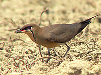
. The lagoons are also an important site for shorebirds
Wader
Waders, called shorebirds in North America , are members of the order Charadriiformes, excluding the more marine web-footed seabird groups. The latter are the skuas , gulls , terns , skimmers , and auks...
: several thousand Little Curlew
Little Curlew
The Little Curlew, Numenius minutus, is a wader in the large bird family Scolopacidae. It is a very small curlew, which breeds in the far north of Siberia. It is closely related to the North American Eskimo Curlew....
s and Oriental Pratincole
Oriental Pratincole
The Oriental Pratincole , also known as the Grasshopper-Bird or Swallow-Plover is a wader in the pratincole family, Glareolidae....
s, and hundreds of Wood Sandpiper
Wood Sandpiper
The Wood Sandpiper, Tringa glareola, is a small wader. This Eurasian species is the smallest of the shanks, which are mid-sized long-legged waders of the family Scolopacidae.- Description and systematics :...
s have been counted. The Parry Lagoons are probably the most important site in Australia for both Wood and Marsh Sandpiper
Marsh Sandpiper
The Marsh Sandpiper, Tringa stagnatilis, is a small wader. It is a rather small shank, and breeds in open grassy steppe and taiga wetlands from easternmost Europe to central Asia....
s. When local rainfall is high the lagoons and other seasonal wetlands are major breeding areas for waterbirds in the Kimberley, with up to 77 species recorded in habitats associated with Parry Creek. The grasslands are the only place in Western Australia where Zitting Cisticola
Zitting Cisticola
The Zitting Cisticola or Streaked Fantail Warbler , is widely distributed Old World warbler whose breeding range includes southern Europe, Africa outside the deserts and rainforest, and southern Asia down to northern Australia...
s occur naturally. The mangroves contain 12 of the 13 species of terrestrial bird restricted to such habitat, or to rainforest, in Western Australia, including the Black Butcherbird
Black Butcherbird
The Black Butcherbird is a species of bird in the Cracticidae family.It is found in Australia, Indonesia, and Papua New Guinea....
. About 200 bird species have been recorded from the site.
Other fauna
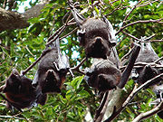
The lower Ord River contains a high density of Salt water Crocodiles. The mangroves support at least six species of microbatMicrobat
The microbats constitute the suborder Microchiroptera within the order Chiroptera . They are most often referred to by their scientific name...
, the Black Flying-fox
Black Flying-fox
The Black Flying-Fox, Pteropus alecto, is a megabat in the family Pteropodidae. Members of the genus Pteropus include the largest bats in the world. The Pteropus genus has currently about 57 recognised species...
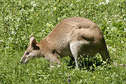
and Grassland Melomys. Other mammals known from the site include: the Northern Nail-tail Wallaby
Northern Nail-tail Wallaby
The Northern Nail-tail Wallaby , also known as the Sandy Nail-tail Wallaby, is a species of macropod found in Queensland, Western Australia and Northern Territory. Unlike the Bridled Nail-tail Wallaby , the Northern Nail-tail Wallaby is not a threatened species. The only other member of the genus,...
, Agile Wallaby
Agile Wallaby
The Agile Wallaby , also known as the Sandy Wallaby, is a species of wallaby found in northern Australia and New Guinea. It is the most common wallaby in Australia's north....
, Long-haired Rat
Long-Haired Rat
Rattus villosissimus, the Australian Long-haired Rat, is a species of rodent in the family Muridae. It is endemic to Australia, where its core range is "the Barkly lake system of the Barkly Tableland of the Northern Territory and the Channel Country in Southwest Queensland and north-eastern South...
and Kimberley Rock Rat. The critically endangered
Critically endangered
Version 2010.3 of the IUCN Red List of Threatened Species identified 3744 Critically Endangered species, subspecies and varieties, stocks and subpopulations.Critically Endangered by kingdom:*1993 Animalia*2 Fungi*1745 Plantae*4 Protista-References:...
Largetooth Sawfish
Largetooth sawfish
The largetooth sawfish , also known as the Leichhardt's sawfish or freshwater sawfish, is a sawfish of the family Pristidae, found in shallow Indo-West Pacific oceans between latitudes 11° N and 39° S. As its relatives, it also enters freshwater. This critically endangered species reaches a length...
has been collected from the lower Ord River.
Human activity
Aboriginal peopleIndigenous Australians
Indigenous Australians are the original inhabitants of the Australian continent and nearby islands. The Aboriginal Indigenous Australians migrated from the Indian continent around 75,000 to 100,000 years ago....
have a complex and spiritual relationship with the land and waters of the Ord River. The site lies within the traditional lands of the Miriuwung
Miriwoong language
Miriwoong is an Australian Indigenous language which today has about 20 speakers, most of whom live in or near Kununurra in Western Australia....
and Gajerrong
Gajirrabeng language
Gajirrabeng is an Australian Aboriginal language of the Kimberley region, today known by only three or four fluent speakers....
language groups, and there are many cultural heritage sites, including those concerned with ceremonial, mythological and burial activities, associated with the river.
The area is a regular tourist
Tourism
Tourism is travel for recreational, leisure or business purposes. The World Tourism Organization defines tourists as people "traveling to and staying in places outside their usual environment for not more than one consecutive year for leisure, business and other purposes".Tourism has become a...
destination. Some exploration for alluvial diamond
Diamond
In mineralogy, diamond is an allotrope of carbon, where the carbon atoms are arranged in a variation of the face-centered cubic crystal structure called a diamond lattice. Diamond is less stable than graphite, but the conversion rate from diamond to graphite is negligible at ambient conditions...
s takes place. The surrounding land is used for cattle grazing
Cattle station
Cattle station is an Australian term for a large farm , whose main activity is the rearing of cattle. In Australia, the owner of a cattle station is called a grazier...
.