

Novaya Chara
Encyclopedia
Novaya Chara is an urban locality (an urban-type settlement
) in Kalarsky District
of Zabaykalsky Krai, Russia
. Population:
, in the eastern Stanovoy Range, approximately 600 kilometres (372.8 mi) in a straight line northeast of the krai's administrative center of Chita, and 16 kilometres (9.9 mi) from the district's administrative center of Chara
.
; as part of the BAM project, sections of the route were placed under the patronage of Komsomol
brigades from different parts of the Soviet Union
.
Regular rail traffic from Tynda
in Amur Oblast
to Novaya Chara began in 1988; traffic from the west of the settlement on the section from Severobaykalsk
started in 1989. The completion of the BAM did not bring the expected economic development to the area, and with the economic crisis of the late 1980s, around half the population left. Nearby are the Udokan copper mines and the Chineysky vanadium deposit.
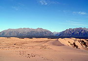 Novaya Chara is the starting point for trekking
tours in the Kodar Mountains, as well as the Chara Sands, a 37 square kilometres (14.3 sq mi) area of sand dunes northwest of the settlement, across the river.
, vanadium
, and iron ore mine Chineyskoye.
The Chineyskoye mine contains both Russia's largest titanium deposit, and the world's largest recorded vanadium deposit. Due to financing problems with the mines, located at an altitude of over 2000 metres (6,561.7 ft), the branch line has been poorly maintained and damaged by landslides, meaning that in 2008 only 26 kilometres (16.2 mi) were in use; with trucks being used to transport ore to the railhead. Repair and reconstruction of the line is currently being undertaken.
Also on this branch line are the rare earth metal mine Katuginskoye, iron ore mine Sulumatskoye, and large anthracite deposits at Chitkanda.
The settlement is also serviced by a small airport.
Urban-type settlement
Urban-type settlement ; , selyshche mis'koho typu ) is an official designation for a type of locality used in some of the countries of the former Soviet Union...
) in Kalarsky District
Kalarsky District
Kalarsky District is an administrative and municipal district , one of the 31 in Zabaykalsky Krai, Russia. The area of the district is . Its administrative center is the rural locality of Chara. Population: 9,785 ; Population of Chara accounts for 21.1% of the district's population.The...
of Zabaykalsky Krai, Russia
Russia
Russia or , officially known as both Russia and the Russian Federation , is a country in northern Eurasia. It is a federal semi-presidential republic, comprising 83 federal subjects...
. Population:
Geography
The settlement lies in the basin of the Chara RiverChara River
The Chara River is an long tributary of the Olyokma in Eastern Siberia, Russia.-Course:The Chara begains as an outflow of the Bolshoye Leprindo lake in the Kodar Mountains, in the northern Zabaykalsky Krai. It flows through the Chara Basin between the Kodar and Kalar Mountains, passing the Chara...
, in the eastern Stanovoy Range, approximately 600 kilometres (372.8 mi) in a straight line northeast of the krai's administrative center of Chita, and 16 kilometres (9.9 mi) from the district's administrative center of Chara
Chara
-Geography:*Chara , a rural locality in Zabaykalsky Krai, Russia*Chara Airport located there*Chara River, a river in Russia-Science:*Chara , a genus of algae in the family Characeae...
.
History
It was founded in connection to the construction of the Baikal Amur Mainline in the 1980s, near the older village of Chara, named for the river on which it stood. The station and settlement were built by workers from the Kazakh SSRKazakh SSR
The Kazakh Soviet Socialist Republic , also known as the Kazakh SSR for short, was one of republics that made up the Soviet Union.At in area, it was the second largest constituent republic in the USSR, after the Russian SFSR. Its capital was Alma-Ata . Today it is the independent state of...
; as part of the BAM project, sections of the route were placed under the patronage of Komsomol
Komsomol
The Communist Union of Youth , usually known as Komsomol , was the youth division of the Communist Party of the Soviet Union. The Komsomol in its earliest form was established in urban centers in 1918. During the early years, it was a Russian organization, known as the Russian Communist Union of...
brigades from different parts of the Soviet Union
Soviet Union
The Soviet Union , officially the Union of Soviet Socialist Republics , was a constitutionally socialist state that existed in Eurasia between 1922 and 1991....
.
Regular rail traffic from Tynda
Tynda
Tynda is a town in Amur Oblast, Russia. It is an important railway junction, often referred to as the capital of the BAM. The name is of Evenk origin, tendy translating roughly as on the river bank. Population: -Geography:...
in Amur Oblast
Amur Oblast
Amur Oblast is a federal subject of Russia , situated about east of Moscow on the banks of the Amur and Zeya Rivers. It shares its border with the Sakha Republic in the north, Khabarovsk Krai and the Jewish Autonomous Oblast in the east, People's Republic of China in the south, and Zabaykalsky...
to Novaya Chara began in 1988; traffic from the west of the settlement on the section from Severobaykalsk
Severobaykalsk
Severobaykalsk is a town in the Republic of Buryatia, Russia, located on the northern end of Lake Baikal at the mouth of the Tyya River, northwest of Ulan-Ude and northeast of Irkutsk...
started in 1989. The completion of the BAM did not bring the expected economic development to the area, and with the economic crisis of the late 1980s, around half the population left. Nearby are the Udokan copper mines and the Chineysky vanadium deposit.
Tourism
Backpacking (wilderness)
Backpacking combines the activities of hiking and camping for an overnight stay in backcountry wilderness...
tours in the Kodar Mountains, as well as the Chara Sands, a 37 square kilometres (14.3 sq mi) area of sand dunes northwest of the settlement, across the river.
Economy and infrastructure
Novaya Chara's only real economic activity centers around its situation as an important station on the BAM. However, there is potential for the settlement to become the center for a mining region currently under development, with a 66 kilometres (41 mi) branch line built between 1998 and 2002 from Novaya Chara to the titaniumTitanium
Titanium is a chemical element with the symbol Ti and atomic number 22. It has a low density and is a strong, lustrous, corrosion-resistant transition metal with a silver color....
, vanadium
Vanadium
Vanadium is a chemical element with the symbol V and atomic number 23. It is a hard, silvery gray, ductile and malleable transition metal. The formation of an oxide layer stabilizes the metal against oxidation. The element is found only in chemically combined form in nature...
, and iron ore mine Chineyskoye.
The Chineyskoye mine contains both Russia's largest titanium deposit, and the world's largest recorded vanadium deposit. Due to financing problems with the mines, located at an altitude of over 2000 metres (6,561.7 ft), the branch line has been poorly maintained and damaged by landslides, meaning that in 2008 only 26 kilometres (16.2 mi) were in use; with trucks being used to transport ore to the railhead. Repair and reconstruction of the line is currently being undertaken.
Also on this branch line are the rare earth metal mine Katuginskoye, iron ore mine Sulumatskoye, and large anthracite deposits at Chitkanda.
The settlement is also serviced by a small airport.