
North Industrial, Saskatoon
Encyclopedia
| City of Saskatoon Neighbourhoods | |
|---|---|
| North Industrial | |
| North West Industrial Suburban Development Area | |
 |
|
| Industrial land Selling Price: | $170,000-$260,000 / acre |
| Average Building Selling Price: | $55/Square Foot |
| Total Land Area | 639.9 acres (2.6 km²) |
| Occupancy | 93% |
| Vacant Lots | 44.5 acres (180,085.3 m²) |
| Serviced undeveloped | 98% |
| IH zoned | 248.08 acres (1 km²) |
| IH Occupancy | 44% |
| IL1 zoned | 347.3 acres (1.4 km²) |
| IL1 Occupancy | 56% |
| c2006 | |
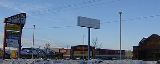
North Industrial is a thriving industrial community in the city of Saskatoon
Saskatoon
Saskatoon is a city in central Saskatchewan, Canada, on the South Saskatchewan River. Residents of the city of Saskatoon are called Saskatonians. The city is surrounded by the Rural Municipality of Corman Park No. 344....
, Saskatchewan
Saskatchewan
Saskatchewan is a prairie province in Canada, which has an area of . Saskatchewan is bordered on the west by Alberta, on the north by the Northwest Territories, on the east by Manitoba, and on the south by the U.S. states of Montana and North Dakota....
, which consists primarily of industrial and retail development.
Industrial characteristics
Undeveloped land, office space, and existing industrial facilities are available in Saskatoon albeit considering Saskatoon's economic growth over the past years has been exponential. Industrial footage can be rented between $4.00 and $7.00, whereas Office square footage runs about $6.00. North Industrial contains Suburban Office Housing by providing 20.9% of Saskatoon's office real estate or 451607 square feet (41,955.7 m²). The north industrial fully serviced premium location industrial lots sell for about $190,000 an acre.Layout
51st Street is the northern edge of this industrial area. Idylwyld DriveIdylwyld Drive
Idylwyld Drive is an arterial road in Saskatoon, Saskatchewan. It is one of the main roads in and out of the downtown area of the city.On the south side of the Senator Sid Buckwold Bridge, it is a freeway and is known as the Idylwyld Freeway. It eventually turns into Circle Drive, just east of...
runs concurrent with Highway 11
Saskatchewan Highway 11
Highway 11 is a major north-south highway in Saskatchewan, Canada that connects the province's three largest cities: Regina, Saskatoon and Prince Albert. It is a structural pavement major arterial highway which is approximately long. It is also known as the Louis Riel Trail after the 19th century...
or Louis Riel Trail
Saskatchewan Highway 11
Highway 11 is a major north-south highway in Saskatchewan, Canada that connects the province's three largest cities: Regina, Saskatoon and Prince Albert. It is a structural pavement major arterial highway which is approximately long. It is also known as the Louis Riel Trail after the 19th century...
which runs concurrent with the Yellowhead Highway
Yellowhead Highway
The Yellowhead Highway is a major east-west highway connecting the four western Canadian provinces of British Columbia, Alberta, Saskatchewan, and Manitoba. Although part of the Trans-Canada Highway system, the highway should not be confused with the more southerly, originally-designated...
and Highway 16
Saskatchewan Highway 16
Highway 16 is a provincial paved highway in the Canadian province of Saskatchewan. It is the Saskatchewan section of the Yellowhead Highway, and also the Trans-Canada Highway Yellowhead section. The main purpose of this highway is to connect Saskatchewan with Canadian cities such as Edmonton and...
marks the western boundary. Whereas Railway tracks which are parallel to Millar Avenue mark the eastern. To the south Circle Drive
Circle Drive
Circle Drive is a major road constructed as a ring road in Saskatoon, Saskatchewan, Canada. The northeastern portion of the road is part of the Yellowhead Highway.-History:...
which is concurrent with the Yellowhead Highway
Yellowhead Highway
The Yellowhead Highway is a major east-west highway connecting the four western Canadian provinces of British Columbia, Alberta, Saskatchewan, and Manitoba. Although part of the Trans-Canada Highway system, the highway should not be confused with the more southerly, originally-designated...
, Trans-Canada Highway
Trans-Canada Highway
The Trans-Canada Highway is a federal-provincial highway system that joins the ten provinces of Canada. It is, along with the Trans-Siberian Highway and Australia's Highway 1, one of the world's longest national highways, with the main route spanning 8,030 km...
, and Highway 16
Saskatchewan Highway 16
Highway 16 is a provincial paved highway in the Canadian province of Saskatchewan. It is the Saskatchewan section of the Yellowhead Highway, and also the Trans-Canada Highway Yellowhead section. The main purpose of this highway is to connect Saskatchewan with Canadian cities such as Edmonton and...
is included. At the southern perimeter all properties which extend from Venture Crescent and 40A Street East.
Until the late 1990s, North Industrial also included the industrial lands north of 51st Street, west of the rail line, and east of Idylwyld Drive up to 60th Street, but a reorganization of community boundaries resulted in the area north of 51st Street being redesignated Hudson Bay Industrial.
History
The Skyway Drive-In remained open until the mid 1970's and was located north of Circle Drive or 42nd Street or at the SE quarter of Section 34, Twp. 28, Range 24, Meridian W3. Presently if it was still existing it would be just north of 44th Street between Faithfull Avenue and Northridge Drive.River City Centre Mall
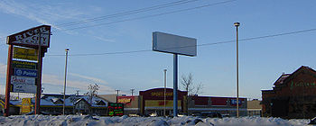
River City Centre MallRiver City Centre (Saskatoon)
River City Centre is a type of a "big box" shopping centre or power centre in the north industrial area of Saskatoon. Some of the anchors are Sport Mart , Sears Home , Scott's Parable Christian Stores, Dollarama, and Staples Business Depot...
is Saskatoon's first big box venture, which seems to be the new layout for developers. This River City Centre Mall located at Circle Drive and Millar Avenue sold for $22 Million in April 2006.
Bridges
42nd Street BridgeCircle Drive Bridge (Saskatoon)
Circle Drive Bridge spans the South Saskatchewan River in Saskatoon, Saskatchewan Canada. It is a steel girder bridge, built in 1983 as part of the Circle Drive freeway system in northeast Saskatoon. At the time of construction, it cost $11.8 million to build...
connects the North Industrial conveniently with many major highways and cities for trucking route of the industrial sector and trading economics. The bridge also services connection between the eastern side of the City of Saskatoon enabling consumer and employee transportation.
Location
Coordinates: 52°9'42"N 106°40'2"W| North: Hudson Bay Industrial | ||
| West: Airport Business Area | North Industrial | East: Lawson Heights Suburban Centre River Heights |
| South: Kelsey-Woodlawn |