

New York State Route 318
Encyclopedia
New York State Route 318 (NY 318) is an east–west state highway
in the Finger Lakes
region of New York
, United States
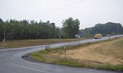
. The western terminus of the route is at an intersection with NY 14
at New York State Thruway
(Interstate 90 or I-90) exit 42 in the town of Phelps
. The eastern terminus is at an intersection that includes U.S. Route 20 (US 20), NY 5
and NY 89
northeast of the village of Seneca Falls
. All but 0.7 miles (1.13 km) of the 10.9 miles (17.54 km) route is located in Seneca County
.
The origins of NY 318 date back to the 19th century when the highway was part of a road connecting the village of Phelps
to a bridge over the Seneca River
near Cayuga Lake
. It was mostly designated as Route 6-a, an unsigned legislative route
, by the New York State Legislature in 1911. The section of Route 6-a from West Junius to Halsey Corners was designated as New York State Route 291 (west of Magee) and part of NY 89
(east of Magee) as part of the 1930 renumbering of state highways in New York. NY 291 was removed in the 1940s.
The alignments of NY 89 and NY 414
north of Seneca Falls were largely flipped in the 1950s, placing both highways on their modern alignments. Part of NY 89's former routing became a short-lived extension of New York State Route 390. All of NY 89's former routing from Magee to Halsey Corners was designated as NY 318 ca. 1963. NY 318 was extended west to NY 14 in the 1970s over former NY 291.
in an area of the Ontario County
town of Phelps
known as West Junius. West of the intersection, the right-of-way for NY 318 leads to the toll barrier for New York State Thruway
(I-90) exit 42. The route heads eastward, crossing the Norfolk Southern Railway
Corning Secondary line before passing into Seneca County
a mere 0.7 miles (1.13 km) from NY 14.
 Now in the town of Junius
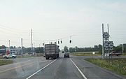
, the route follows an alignment parallel to that of the Thruway as it passes south of a large housing development and by a series of small lakes collectively known as Junius Ponds. NY 318 continues on, passing through a mixture of forested areas and cultivated fields as it heads eastward through the town. Just past an intersection with Nine Foot Road (County Route 108 or CR 108), NY 318 serves the Waterloo Premium Outlets, a large collection of outlet stores situated between NY 318 and the Thruway. Past the outlet mall, the route continues through largely rural surroundings to the community of Stone Church Corner, where it briefly curves to the northeast before veering back to the east as it enters the town of Tyre
.
 Roughly 0.5 mile (0.80467 km) from the town line, NY 318 enters the hamlet of Magee, a small community centered around NY 318's junction with NY 414
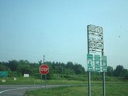
(Ridge Road). East of Magee, NY 318 turns to the southeast and begins to separate from the Thruway as it passes through vast, open fields. At the community of Nichols Corners, located at the intersection of NY 318 and Gravel Road (CR 101), the route curves back to the east and begins to straddle the Tyre – Seneca Falls
town line. NY 318 ends 1.35 miles (2.17 km) later at an intersection with US 20, NY 5
, and NY 89
at Halsey Corners just west of the Montezuma National Wildlife Refuge
and northwest of Cayuga Lake
.
. The bridge was ultimately constructed just north of Cayuga Lake
near the site of the modern US 20 / NY 5
crossing over the river. A road was later built to connect the bridge to the village of Phelps
by way of West Junius and Magee. The highway became known as the "free bridge state road". In 1908, the portion of the road from the free bridge to Halsey Corners was included as part of Route 6, an unsigned legislative route
defined by the New York State Legislature as beginning in Buffalo
and ending in Albany
. The remainder of the old free bridge highway was designated as Route 6-a in 1911.
 When the first set of posted routes in New York
were assigned in 1924, the portion of Route 6-a from Phelps to West Junius was incorporated into NY 15 (modern NY 96
), a route extending from Owego
to Rochester
. Farther east, the Route 6 segment of the old free bridge road was co-designated
as part of NY 5
and NY 5A (now US 20 and NY 5), two cross-state highways linking Western New York
to the Capital District
. The remainder of the old highway—namely Route 6-a from West Junius to Halsey Corners—did not initially receive a designation.
, which originally continued north from Magee to North Rose on what is now NY 414
. At the same time, Black Brook Road, a connector between the village of Seneca Falls
and NY 89 east of Magee, was assigned NY 390. In the mid-1930s, the portion of Gravel Road between US 20 and NY 5 and NY 89 was designated as NY 390A. The route was a spur route of NY 390 in name only as NY 390A never connected to NY 390. The NY 291 designation was deleted in the early 1940s.
The alignments of NY 89 and NY 414 north of US 20 and NY 5
were mostly swapped in the late 1950s; however, NY 414 continued south of Magee along its current alignment instead. At the same time, NY 390 was extended westward to Magee along the former routing of NY 89 while the NY 390A designation was deleted. The entirety of NY 89's former routing from Magee to Halsey Corners was redesignated as NY 318 ca. 1963, resulting in the truncation of NY 390 back to its previous northern terminus before being removed altogether in the mid-1960s. NY 318 was extended west to its current terminus at NY 14
in West Junius in the mid-1970s. The former routings of NY 390 and NY 390A between NY 318 and the Seneca Falls village line are now maintained by Seneca County
as CR 102 (Black Brook Road) and part of CR 101 (Gravel Road), respectively.
State highway
State highway, state road or state route can refer to one of three related concepts, two of them related to a state or provincial government in a country that is divided into states or provinces :#A...
in the Finger Lakes
Finger Lakes
The Finger Lakes are a pattern of lakes in the west-central section of Upstate New York in the United States. They are a popular tourist destination. The lakes are long and thin , each oriented roughly on a north-south axis. The two longest, Cayuga Lake and Seneca Lake, are among the deepest in...
region of New York
New York
New York is a state in the Northeastern region of the United States. It is the nation's third most populous state. New York is bordered by New Jersey and Pennsylvania to the south, and by Connecticut, Massachusetts and Vermont to the east...
, United States
United States
The United States of America is a federal constitutional republic comprising fifty states and a federal district...
. The western terminus of the route is at an intersection with NY 14
New York State Route 14
New York State Route 14 is a state highway located in western New York in the United States. Along with NY 19, it is one of two routes to transect the state in a north–south fashion between the Pennsylvania border and Lake Ontario...
at New York State Thruway
New York State Thruway
The New York State Thruway is a system of limited-access highways located within the state of New York in the United States. The system, known officially as the Governor Thomas E. Dewey Thruway for former New York Governor Thomas E. Dewey, is operated by the New York State Thruway Authority and...
(Interstate 90 or I-90) exit 42 in the town of Phelps
Phelps (town), New York
Phelps is a town in Ontario County, New York, USA. The population was 7,017 at the 2000 census. The town is named after one of the original proprietors.The Town of Phelps contains a village called Phelps. Both are north of Geneva, New York....
. The eastern terminus is at an intersection that includes U.S. Route 20 (US 20), NY 5
New York State Route 5
New York State Route 5 is a state highway that extends for across the state of New York in the United States. It begins at the Pennsylvania state line in the Chautauqua County town of Ripley and passes through Buffalo, Syracuse, Utica, Schenectady, and several other smaller cities and...
and NY 89
New York State Route 89
New York State Route 89 is a north–south state highway in central New York in the United States. It extends for from an intersection with NY 13, NY 34, and NY 96 in the Tompkins County city of Ithaca to an interchange with NY 104 in the Wayne County town of town of Wolcott...
northeast of the village of Seneca Falls
Seneca Falls (village), New York
Seneca Falls is a village in Seneca County, New York, United States. The population was 6,861 at the 2000 census. The village is in the Town of Seneca Falls, east of Geneva, New York. On March 16, 2010, village residents voted to dissolve the village, a move that would take effect at the end of 2011...
. All but 0.7 miles (1.13 km) of the 10.9 miles (17.54 km) route is located in Seneca County
Seneca County, New York
As of the census of 2000, there were 33,342 people, 12,630 households, and 8,626 families residing in the county. The population density was 103 people per square mile . There were 14,794 housing units at an average density of 46 per square mile...
.
The origins of NY 318 date back to the 19th century when the highway was part of a road connecting the village of Phelps
Phelps (village), New York
Phelps is a village in Ontario County, New York, USA. The population was 1,969 at the 2000 census. The village is named after an original proprietor, Oliver Phelps....
to a bridge over the Seneca River
Seneca River (New York)
The Seneca River in central New York flows from west to east, from Seneca Lake, through the Montezuma Marsh at the north end of Cayuga Lake to the Seneca's confluence with the Oneida and Oswego rivers at the Three Rivers area north of Syracuse. Much of the river has been channelized to form part...
near Cayuga Lake
Cayuga Lake
Cayuga Lake is the longest of central New York's glacial Finger Lakes, and is the second largest in surface area and second largest in volume. It is just under 40 miles long. Its average width is 1.7 miles , and it is at its widest point near Aurora...
. It was mostly designated as Route 6-a, an unsigned legislative route
Legislative route
In United States, a legislative route or legislative highway is a highway defined by laws passed in a state legislature. The numbering of such highways may or may not correspond to the numbers familiar to the public as part of the state, U.S. highway, and Interstate highway systems...
, by the New York State Legislature in 1911. The section of Route 6-a from West Junius to Halsey Corners was designated as New York State Route 291 (west of Magee) and part of NY 89
New York State Route 89
New York State Route 89 is a north–south state highway in central New York in the United States. It extends for from an intersection with NY 13, NY 34, and NY 96 in the Tompkins County city of Ithaca to an interchange with NY 104 in the Wayne County town of town of Wolcott...
(east of Magee) as part of the 1930 renumbering of state highways in New York. NY 291 was removed in the 1940s.
The alignments of NY 89 and NY 414
New York State Route 414
New York State Route 414 is a north–south state highway in the Southern Tier and Finger Lakes regions of New York in the United States. It extends for from an intersection with NY 352 in the Steuben County city of Corning to a junction with NY 104 in the Wayne County town of Huron...
north of Seneca Falls were largely flipped in the 1950s, placing both highways on their modern alignments. Part of NY 89's former routing became a short-lived extension of New York State Route 390. All of NY 89's former routing from Magee to Halsey Corners was designated as NY 318 ca. 1963. NY 318 was extended west to NY 14 in the 1970s over former NY 291.
Route description
NY 318 begins at an intersection with NY 14New York State Route 14
New York State Route 14 is a state highway located in western New York in the United States. Along with NY 19, it is one of two routes to transect the state in a north–south fashion between the Pennsylvania border and Lake Ontario...
in an area of the Ontario County
Ontario County, New York
As of the census of 2000, there were 100,224 people, 38,370 households, and 26,360 families residing in the county. The population density was 156 people per square mile . There were 42,647 housing units at an average density of 66 per square mile...
town of Phelps
Phelps (town), New York
Phelps is a town in Ontario County, New York, USA. The population was 7,017 at the 2000 census. The town is named after one of the original proprietors.The Town of Phelps contains a village called Phelps. Both are north of Geneva, New York....
known as West Junius. West of the intersection, the right-of-way for NY 318 leads to the toll barrier for New York State Thruway
New York State Thruway
The New York State Thruway is a system of limited-access highways located within the state of New York in the United States. The system, known officially as the Governor Thomas E. Dewey Thruway for former New York Governor Thomas E. Dewey, is operated by the New York State Thruway Authority and...
(I-90) exit 42. The route heads eastward, crossing the Norfolk Southern Railway
Norfolk Southern Railway
The Norfolk Southern Railway is a Class I railroad in the United States, owned by the Norfolk Southern Corporation. With headquarters in Norfolk, Virginia, the company operates 21,500 route miles in 22 eastern states, the District of Columbia and the province of Ontario, Canada...
Corning Secondary line before passing into Seneca County
Seneca County, New York
As of the census of 2000, there were 33,342 people, 12,630 households, and 8,626 families residing in the county. The population density was 103 people per square mile . There were 14,794 housing units at an average density of 46 per square mile...
a mere 0.7 miles (1.13 km) from NY 14.
Junius, New York
Junius is a town in Seneca County, New York, United States. The population was 1,362 at the 2000 census.The Town of Junius is in the northwest corner of the county and is east of Geneva, New York.- History :...
, the route follows an alignment parallel to that of the Thruway as it passes south of a large housing development and by a series of small lakes collectively known as Junius Ponds. NY 318 continues on, passing through a mixture of forested areas and cultivated fields as it heads eastward through the town. Just past an intersection with Nine Foot Road (County Route 108 or CR 108), NY 318 serves the Waterloo Premium Outlets, a large collection of outlet stores situated between NY 318 and the Thruway. Past the outlet mall, the route continues through largely rural surroundings to the community of Stone Church Corner, where it briefly curves to the northeast before veering back to the east as it enters the town of Tyre
Tyre, New York
Tyre is a town in Seneca County, New York, United States. The population was 899 at the 2000 census. The town is named after the Lebanese city of Tyre.The Town of Tyre is located in the northeastern part of the county, northeast of Geneva, New York....
.
New York State Route 414
New York State Route 414 is a north–south state highway in the Southern Tier and Finger Lakes regions of New York in the United States. It extends for from an intersection with NY 352 in the Steuben County city of Corning to a junction with NY 104 in the Wayne County town of Huron...
(Ridge Road). East of Magee, NY 318 turns to the southeast and begins to separate from the Thruway as it passes through vast, open fields. At the community of Nichols Corners, located at the intersection of NY 318 and Gravel Road (CR 101), the route curves back to the east and begins to straddle the Tyre – Seneca Falls
Seneca Falls (town), New York
Seneca Falls is a town in Seneca County, New York, United States. The population was 9,347 at the 2000 census.The Town of Seneca Falls contains a village also called Seneca Falls...
town line. NY 318 ends 1.35 miles (2.17 km) later at an intersection with US 20, NY 5
New York State Route 5
New York State Route 5 is a state highway that extends for across the state of New York in the United States. It begins at the Pennsylvania state line in the Chautauqua County town of Ripley and passes through Buffalo, Syracuse, Utica, Schenectady, and several other smaller cities and...
, and NY 89
New York State Route 89
New York State Route 89 is a north–south state highway in central New York in the United States. It extends for from an intersection with NY 13, NY 34, and NY 96 in the Tompkins County city of Ithaca to an interchange with NY 104 in the Wayne County town of town of Wolcott...
at Halsey Corners just west of the Montezuma National Wildlife Refuge
Montezuma National Wildlife Refuge
Montezuma National Wildlife Refuge is a wildlife preserve operated by the United States Fish and Wildlife Service, encompassing part of the Montezuma Swamp at the north end of Cayuga Lake...
and northwest of Cayuga Lake
Cayuga Lake
Cayuga Lake is the longest of central New York's glacial Finger Lakes, and is the second largest in surface area and second largest in volume. It is just under 40 miles long. Its average width is 1.7 miles , and it is at its widest point near Aurora...
.
Origins
On April 16, 1825, the New York State Legislature passed an act permitting the construction of a "free bridge" over the Seneca RiverSeneca River (New York)
The Seneca River in central New York flows from west to east, from Seneca Lake, through the Montezuma Marsh at the north end of Cayuga Lake to the Seneca's confluence with the Oneida and Oswego rivers at the Three Rivers area north of Syracuse. Much of the river has been channelized to form part...
. The bridge was ultimately constructed just north of Cayuga Lake
Cayuga Lake
Cayuga Lake is the longest of central New York's glacial Finger Lakes, and is the second largest in surface area and second largest in volume. It is just under 40 miles long. Its average width is 1.7 miles , and it is at its widest point near Aurora...
near the site of the modern US 20 / NY 5
New York State Route 5
New York State Route 5 is a state highway that extends for across the state of New York in the United States. It begins at the Pennsylvania state line in the Chautauqua County town of Ripley and passes through Buffalo, Syracuse, Utica, Schenectady, and several other smaller cities and...
crossing over the river. A road was later built to connect the bridge to the village of Phelps
Phelps (village), New York
Phelps is a village in Ontario County, New York, USA. The population was 1,969 at the 2000 census. The village is named after an original proprietor, Oliver Phelps....
by way of West Junius and Magee. The highway became known as the "free bridge state road". In 1908, the portion of the road from the free bridge to Halsey Corners was included as part of Route 6, an unsigned legislative route
Legislative route
In United States, a legislative route or legislative highway is a highway defined by laws passed in a state legislature. The numbering of such highways may or may not correspond to the numbers familiar to the public as part of the state, U.S. highway, and Interstate highway systems...
defined by the New York State Legislature as beginning in Buffalo
Buffalo, New York
Buffalo is the second most populous city in the state of New York, after New York City. Located in Western New York on the eastern shores of Lake Erie and at the head of the Niagara River across from Fort Erie, Ontario, Buffalo is the seat of Erie County and the principal city of the...
and ending in Albany
Albany, New York
Albany is the capital city of the U.S. state of New York, the seat of Albany County, and the central city of New York's Capital District. Roughly north of New York City, Albany sits on the west bank of the Hudson River, about south of its confluence with the Mohawk River...
. The remainder of the old free bridge highway was designated as Route 6-a in 1911.
New York
New York is a state in the Northeastern region of the United States. It is the nation's third most populous state. New York is bordered by New Jersey and Pennsylvania to the south, and by Connecticut, Massachusetts and Vermont to the east...
were assigned in 1924, the portion of Route 6-a from Phelps to West Junius was incorporated into NY 15 (modern NY 96
New York State Route 96
New York State Route 96 is a northwest–southeast state highway in the Finger Lakes region of New York in the United States. The southern terminus of the route is at an interchange with NY 17 in the Southern Tier village of Owego, Tioga County. Its northern terminus is at a junction with...
), a route extending from Owego
Owego (village), New York
Owego is a village in and the county seat of Tioga County, New York, USA. The population was 3,911 at the 2000 census. It is part of the Binghamton Metropolitan Statistical Area...
to Rochester
Rochester, New York
Rochester is a city in Monroe County, New York, south of Lake Ontario in the United States. Known as The World's Image Centre, it was also once known as The Flour City, and more recently as The Flower City...
. Farther east, the Route 6 segment of the old free bridge road was co-designated
Concurrency (road)
A concurrency, overlap, or coincidence in a road network is an instance of one physical road bearing two or more different highway, motorway, or other route numbers...
as part of NY 5
New York State Route 5
New York State Route 5 is a state highway that extends for across the state of New York in the United States. It begins at the Pennsylvania state line in the Chautauqua County town of Ripley and passes through Buffalo, Syracuse, Utica, Schenectady, and several other smaller cities and...
and NY 5A (now US 20 and NY 5), two cross-state highways linking Western New York
Western New York
Western New York is the westernmost region of the state of New York. It includes the cities of Buffalo, Rochester, Niagara Falls, the surrounding suburbs, as well as the outlying rural areas of the Great Lakes lowlands, the Genesee Valley, and the Southern Tier. Some historians, scholars and others...
to the Capital District
Capital District
New York's Capital District, also known as the Capital Region, is a region in upstate New York that generally refers to the four counties surrounding Albany, the capital of the state: Albany County, Schenectady County, Rensselaer County, and Saratoga County...
. The remainder of the old highway—namely Route 6-a from West Junius to Halsey Corners—did not initially receive a designation.
Designations
The entirety of old Route 6-a between West Junius and Halsey Corners was assigned a designation as part of the 1930 renumbering of state highways in New York. From West Junius to Magee, the highway was designated as NY 291; meanwhile, the section from Magee to Halsey Corners became part of NY 89New York State Route 89
New York State Route 89 is a north–south state highway in central New York in the United States. It extends for from an intersection with NY 13, NY 34, and NY 96 in the Tompkins County city of Ithaca to an interchange with NY 104 in the Wayne County town of town of Wolcott...
, which originally continued north from Magee to North Rose on what is now NY 414
New York State Route 414
New York State Route 414 is a north–south state highway in the Southern Tier and Finger Lakes regions of New York in the United States. It extends for from an intersection with NY 352 in the Steuben County city of Corning to a junction with NY 104 in the Wayne County town of Huron...
. At the same time, Black Brook Road, a connector between the village of Seneca Falls
Seneca Falls (village), New York
Seneca Falls is a village in Seneca County, New York, United States. The population was 6,861 at the 2000 census. The village is in the Town of Seneca Falls, east of Geneva, New York. On March 16, 2010, village residents voted to dissolve the village, a move that would take effect at the end of 2011...
and NY 89 east of Magee, was assigned NY 390. In the mid-1930s, the portion of Gravel Road between US 20 and NY 5 and NY 89 was designated as NY 390A. The route was a spur route of NY 390 in name only as NY 390A never connected to NY 390. The NY 291 designation was deleted in the early 1940s.
The alignments of NY 89 and NY 414 north of US 20 and NY 5
New York State Route 5
New York State Route 5 is a state highway that extends for across the state of New York in the United States. It begins at the Pennsylvania state line in the Chautauqua County town of Ripley and passes through Buffalo, Syracuse, Utica, Schenectady, and several other smaller cities and...
were mostly swapped in the late 1950s; however, NY 414 continued south of Magee along its current alignment instead. At the same time, NY 390 was extended westward to Magee along the former routing of NY 89 while the NY 390A designation was deleted. The entirety of NY 89's former routing from Magee to Halsey Corners was redesignated as NY 318 ca. 1963, resulting in the truncation of NY 390 back to its previous northern terminus before being removed altogether in the mid-1960s. NY 318 was extended west to its current terminus at NY 14
New York State Route 14
New York State Route 14 is a state highway located in western New York in the United States. Along with NY 19, it is one of two routes to transect the state in a north–south fashion between the Pennsylvania border and Lake Ontario...
in West Junius in the mid-1970s. The former routings of NY 390 and NY 390A between NY 318 and the Seneca Falls village line are now maintained by Seneca County
Seneca County, New York
As of the census of 2000, there were 33,342 people, 12,630 households, and 8,626 families residing in the county. The population density was 103 people per square mile . There were 14,794 housing units at an average density of 46 per square mile...
as CR 102 (Black Brook Road) and part of CR 101 (Gravel Road), respectively.