

New York State Route 284
Encyclopedia
New York State Route 284 (NY 284) is a short state highway located entirely in Orange County
in New York
, United States
. It is the continuation of New Jersey Route 284 northbound from the state line at Minisink
(just south of Unionville) to U.S. Route 6
(US 6) in Wawayanda
. The route heads through rural parts of Orange County for 9 miles (14 km), intersecting with several local and county routes along the way.
Route 284 was originally designated as part of New York State Route 8 in 1924. It became part of New York State Route 84 when the portion of NY 8 south of Montgomery
was renumbered to NY 84 in the 1930 renumbering. When Interstate 84
(I-84) was built nearby in May 1966, the route was partially redesignated as NY 284 to prevent confusion.
, Orange County
, as a continuation of New Jersey Route 284. The route heads northwest to the village of Unionville, where it intersects with County Route 36 (CR 36), a route that becomes CR 651 upon entering Sussex County
in New Jersey
. Outside the village, Route 284 curves to the northeast and proceeds through farmlands, paralleling the Middletown and New Jersey Railway
for a short distance.
 The local road then passes Lockhurst Pond and intersects with CR 1 in the hamlet
of Westtown
. Route 284 passes to the southeast of Green Ridge Golf Course as it heads to the northeast. Some local and county routes intersect NY 284 as it heads northeastward into the town of Wawayanda
; however, no state-maintained routes do. Route 284 passes Shannen Park on its way to the hamlet of Slate Hill, where it comes to an end at US 6.
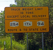
Trucks using NY 284 (along with NY 17A
and NY 94
between US 6 and the state line) are limited to 10 tons (9 tonnes) gross vehicular weight, to better protect the highways' status as key transport routes between I-84
and northwestern New Jersey
.
were assigned in 1924. North of Slate Hill, NY 8 continued northeast to Newburgh
by way of modern US 6, NY 211
and NY 17K
. In the 1930 renumbering, all of NY 8 south of Montgomery
was renumbered to NY 84. The portion of NY 8 east of the village became NY 215. When I-84
was built in May 1966, the NY 84 designation was eliminated to prevent confusion between the two nearby roads. The section of Route 84 south of Slate Hill was renumbered to NY 284, while the remainder of the route became part of US 6 (which NY 84 overlapped) and NY 211.
Orange County, New York
Orange County is a county located in the U.S. state of New York. It is part of the Poughkeepsie–Newburgh–Middletown, NY Metropolitan Statistical Area and is located at the northern reaches of the New York metropolitan area. The county sits in the state's scenic Mid-Hudson Region of the Hudson Valley...
in New York
New York
New York is a state in the Northeastern region of the United States. It is the nation's third most populous state. New York is bordered by New Jersey and Pennsylvania to the south, and by Connecticut, Massachusetts and Vermont to the east...
, United States
United States
The United States of America is a federal constitutional republic comprising fifty states and a federal district...
. It is the continuation of New Jersey Route 284 northbound from the state line at Minisink
Minisink, New York
Minisink is a town located in southwest Orange County, New York northeast of the New Jersey border between the Town of Greenville and the Town of Warwick...
(just south of Unionville) to U.S. Route 6
U.S. Route 6 in New York
U.S. Route 6 is a part of the U.S. Highway System that runs from Bishop, California, to Provincetown, Massachusetts. In New York, US 6 extends from the Pennsylvania state line at Port Jervis to the Connecticut state line east of Brewster...
(US 6) in Wawayanda
Wawayanda, New York
Wawayanda is a town in Orange County, New York, United States. The population was 7,024 as recorded by the 2006 census.The Town of Wawayanda is in the western part of the county, south of Middletown.-History:...
. The route heads through rural parts of Orange County for 9 miles (14 km), intersecting with several local and county routes along the way.
Route 284 was originally designated as part of New York State Route 8 in 1924. It became part of New York State Route 84 when the portion of NY 8 south of Montgomery
Montgomery (village), New York
Montgomery is a village located in Orange County, New York, United States, 60 miles northwest of New York City, and 90 miles southwest of Albany. The population was 3,636 at the 2000 census...
was renumbered to NY 84 in the 1930 renumbering. When Interstate 84
Interstate 84 (east)
Interstate 84 is an Interstate Highway extending from Dunmore, Pennsylvania at an interchange with Interstate 81 to Sturbridge, Massachusetts, at an interchange with the Massachusetts Turnpike . I-84 has mile-log junction numbering in Pennsylvania; otherwise, exit numbers are roughly sequential...
(I-84) was built nearby in May 1966, the route was partially redesignated as NY 284 to prevent confusion.
Route description
NY 284 begins at the state line in MinisinkMinisink, New York
Minisink is a town located in southwest Orange County, New York northeast of the New Jersey border between the Town of Greenville and the Town of Warwick...
, Orange County
Orange County, New York
Orange County is a county located in the U.S. state of New York. It is part of the Poughkeepsie–Newburgh–Middletown, NY Metropolitan Statistical Area and is located at the northern reaches of the New York metropolitan area. The county sits in the state's scenic Mid-Hudson Region of the Hudson Valley...
, as a continuation of New Jersey Route 284. The route heads northwest to the village of Unionville, where it intersects with County Route 36 (CR 36), a route that becomes CR 651 upon entering Sussex County
Sussex County, New Jersey
The County of Sussex is the northernmost county in the State of New Jersey. It is part of the New York City Metropolitan Area. As of the 2010 Federal decennial census, 149,265 persons resided in Sussex County...
in New Jersey
New Jersey
New Jersey is a state in the Northeastern and Middle Atlantic regions of the United States. , its population was 8,791,894. It is bordered on the north and east by the state of New York, on the southeast and south by the Atlantic Ocean, on the west by Pennsylvania and on the southwest by Delaware...
. Outside the village, Route 284 curves to the northeast and proceeds through farmlands, paralleling the Middletown and New Jersey Railway
Middletown and New Jersey Railway
The Middletown and New Jersey Railroad is one of two railroads in the city of Middletown, New York; the other being its interchange partner, Norfolk Southern Railway. The railroad operates one diesel-electric locomotive along 7 miles of track, delivering polystyrene pellets to its sole customer,...
for a short distance.
Hamlet (place)
A hamlet is usually a rural settlement which is too small to be considered a village, though sometimes the word is used for a different sort of community. Historically, when a hamlet became large enough to justify building a church, it was then classified as a village...
of Westtown
Westtown, New York
Westtown is a hamlet in Orange County in the U.S. state of New York. It is located along New York State Route 284 north of Unionville and Minisink, and north of the New Jersey state border. The town is intersected mainly by Orange County Rt. 1. Westtown is a community or populated place located...
. Route 284 passes to the southeast of Green Ridge Golf Course as it heads to the northeast. Some local and county routes intersect NY 284 as it heads northeastward into the town of Wawayanda
Wawayanda, New York
Wawayanda is a town in Orange County, New York, United States. The population was 7,024 as recorded by the 2006 census.The Town of Wawayanda is in the western part of the county, south of Middletown.-History:...
; however, no state-maintained routes do. Route 284 passes Shannen Park on its way to the hamlet of Slate Hill, where it comes to an end at US 6.
Trucks using NY 284 (along with NY 17A
New York State Route 17A
New York State Route 17A is a state highway in southern New York, United States, entirely within Orange County. Its western terminus is located at Goshen at a junction with NY 17, and its eastern terminus is at another intersection with NY 17 located in Southfields. It runs...
and NY 94
New York State Route 94
New York State Route 94 is a state highway entirely within Orange County in southern New York. The western terminus is at the New York-New Jersey state line, where it continues as NJ 94 for another to Columbia, New Jersey. Its eastern terminus is located at U.S. Route 9W in New Windsor....
between US 6 and the state line) are limited to 10 tons (9 tonnes) gross vehicular weight, to better protect the highways' status as key transport routes between I-84
Interstate 84 in New York
Interstate 84 is a part of the Interstate Highway System that runs from Dunmore, Pennsylvania, to Sturbridge, Massachusetts, in the Eastern United States. In New York, I-84 extends from the Pennsylvania state line at Port Jervis to the Connecticut state line east of Brewster...
and northwestern New Jersey
New Jersey
New Jersey is a state in the Northeastern and Middle Atlantic regions of the United States. , its population was 8,791,894. It is bordered on the north and east by the state of New York, on the southeast and south by the Atlantic Ocean, on the west by Pennsylvania and on the southwest by Delaware...
.
History
Route 284 was originally designated as part of NY 8 when the first set of posted routes in New YorkNew York
New York is a state in the Northeastern region of the United States. It is the nation's third most populous state. New York is bordered by New Jersey and Pennsylvania to the south, and by Connecticut, Massachusetts and Vermont to the east...
were assigned in 1924. North of Slate Hill, NY 8 continued northeast to Newburgh
Newburgh (city), New York
Newburgh is a city located in Orange County, New York, United States, north of New York City, and south of Albany, on the Hudson River. Newburgh is a principal city of the Poughkeepsie-Newburgh-Middletown metropolitan area, which includes all of Dutchess and Orange counties. The Newburgh area was...
by way of modern US 6, NY 211
New York State Route 211
New York State Route 211 is a state highway located entirely within Orange County, New York, in the United States. The western terminus is at the intersection with US 209 located in Cuddebackville, and the eastern terminus is located at Montgomery at NY 17K, where it becomes the...
and NY 17K
New York State Route 17K
New York State Route 17K is an east–west state highway located within Orange County, New York, in the United States. It extends for from an intersection with County Route 76 east of Bloomingburg to a junction with U.S. Route 9W midway across the city of Newburgh...
. In the 1930 renumbering, all of NY 8 south of Montgomery
Montgomery (village), New York
Montgomery is a village located in Orange County, New York, United States, 60 miles northwest of New York City, and 90 miles southwest of Albany. The population was 3,636 at the 2000 census...
was renumbered to NY 84. The portion of NY 8 east of the village became NY 215. When I-84
Interstate 84 in New York
Interstate 84 is a part of the Interstate Highway System that runs from Dunmore, Pennsylvania, to Sturbridge, Massachusetts, in the Eastern United States. In New York, I-84 extends from the Pennsylvania state line at Port Jervis to the Connecticut state line east of Brewster...
was built in May 1966, the NY 84 designation was eliminated to prevent confusion between the two nearby roads. The section of Route 84 south of Slate Hill was renumbered to NY 284, while the remainder of the route became part of US 6 (which NY 84 overlapped) and NY 211.