

New York State Route 17M
Encyclopedia
New York State Route 17M (NY 17M) is an east–west state highway
in Orange County
, New York
, in the United States. It extends for 26.63 miles (42.86 km) from west of the city of Middletown
to what is currently the north–south section of NY 17
just southeast of the village of Harriman
. It is a busy main street in Middletown and the village of Monroe
; in the former, it divides into a parkway for several blocks and forms the city's major commercial strip, located between the downtown district and an interchange with Interstate 84
(I-84). The rest of the road is a two-lane rural route. Between New Hampton
and Goshen
, the highway overlaps
with U.S. Route 6
(US 6). The easternmost section of that overlap near Goshen is routed on the Quickway, making a three-route concurrency with NY 17.
Most of NY 17M follows the course used by NY 17 prior to the construction of the Quickway through the Catskill Mountains
. The first section of the Quickway opened in 1951 and extended from Fair Oaks to Goshen. NY 17M was initially assigned to NY 17's old surface routing between Fair Oaks and Middletown; however, it was extended east to Harriman and, for a brief time, northwest to Wurtsboro
as more sections of the freeway were completed.
are maintained by the New York State Department of Transportation
(NYSDOT). Within the Middletown city limits, NY 17M is city-maintained.
(once exit 118A) with the nearby Quickway (NY 17
) in the town of Wallkill
, located in northern Orange County
. The junction was just north of the former right-of-way of the New York, Ontario and Western Railway
, which NY 17M crosses as it makes its way southward over some gentle, lightly developed hills. After 0.5 mile (0.80467 km), the road reaches a signalized intersection with NY 302
, its first junction with another state highway. The junction currently serves as NY 302's southern terminus; however, NY 302 once continued south to Middletown
by way of an overlap with NY 17M. Continuing on, NY 17M traverses increasingly developed areas, passing through the hamlet of Rockville on its way to the densely populated neighborhood of Washington Heights
, situated just outside of Middletown.
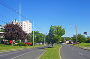 The route seamlessly passes from Washington Heights to Middletown, where it becomes known as North Street. The street is initially fairly wide—featuring shoulders on each side—but it narrows in the residential neighborhoods closer to the city's center. Upon reaching the northern edge of Middletown's central business district, the route turns right onto Wickham Avenue, which carries NY 211
through northern Middletown. The resulting overlap between NY 17M and NY 211 is a wrong-way concurrency: NY 17M eastbound is concurrent with NY 211 westbound and vice versa. Routes 17M and 211 head west along the fringe of downtown, climbing slightly in elevation as the street passes through mostly residential areas. After seven blocks, Wickham Avenue merges into West Main Street; however, the road's surroundings remain unchanged.
NY 17M and NY 211 continue along West Main Street for another four blocks, traversing a slight westerly turn in the street prior to intersecting Monhagen Avenue in the western part of the city. Both routes leave Main Street here: NY 211 turns right, following the road northwest toward Otisville
while NY 17M heads left, proceeding southeastward toward downtown. It continues through a six-block commercial and residential area to Mill Street, at which point Monhagen Avenue becomes Fulton Street and expands to become a parkway
with a tree-lined median strip
. This stretch continues for five blocks along the southern edge of downtown Middletown to Academy Avenue, where NY 17M turns right and heads southward. After just two blocks, the route changes streets for the final time in Middletown, veering left onto Dolson Avenue.
 As Dolson Avenue, NY 17M passes by a single residential block before entering a linear commercial district that follows the highway to an interchange with I-84
roughly 1.5 miles (2.4 km) to the south. The route initially remains two lanes wide, but widens to four lanes after crossing the Middletown and New Jersey Railway
at-grade. This stretch of NY 17M also features a center left-turn lane to accommodate the traffic turning into the many commercial plazas on either side. The road remains within the Middletown city limits until a block before the intersection where US 6
comes in from the west and joins NY 17M. Together, they cross over I-84 at exit 3, providing access to the cities of Port Jervis
and Newburgh
in the western and eastern parts of the county, respectively.
Just past I-84, the Wawayanda
hamlet of New Hampton
begins, with car dealerships and other commercial establishments on either side. The road narrows to two lanes as the combined highways begin a slow, gentle descent through less developed areas to the bridge over the Wallkill River
, situated at the northern tip of the county's Black Dirt Region
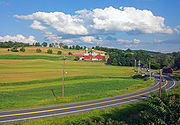
. Short sections of the approach on either side add a passing lane in the uphill direction. The river marks the Goshen town
line, and the slight climb out of the river depression is accompanied again with some extra lanes. Past the climb, development aside the road picks up slightly, although most of the land around the highway remains undeveloped as open fields or forests. US 6 and NY 17M continue to the western outskirts of the village of Goshen
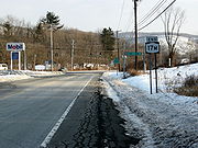
, where they merge into NY 17 at exit 123.
 NY 17M follows the Quickway for about 1 miles (1.6 km), meeting NY 17A
and NY 207
at an interchange (exit 124) in a commercialized area southwest of the center of Goshen. It ultimately leaves the Quickway before US 6 does, splitting from the highway at exit 125. From here to the village of Chester
, NY 17M closely follows the NY 17 freeway, serving a handful of homes in an otherwise undeveloped area adjacent to the Quickway. In Chester, NY 17M becomes Brookside Avenue and intersects with NY 94
in the commercial center of the community. It continues on, passing through the rural areas of the southern portion of the town of Blooming Grove
prior to becoming heavily developed as it passes into the town of Monroe
.
Just inside the town line, NY 17M turns southward, leaving the vicinity of the Quickway and entering the village of Monroe
. It bypasses the downtown portion of the village and its historic district
to the west and south. Despite this fact, it still serves as one of the community's major commercial strips, intersecting NY 208
in a built-up area due west of downtown. The route continues to the east, serving commercial and residential areas on its way to the nearby village of Harriman
. Development abates slightly past Harriman as NY 17M continues with a slight southward bent towards its final junction with NY 17 just outside of the Harriman village limits in the town and village of Woodbury
.
extended across the Southern Tier
of New York, beginning near the shores of Lake Erie
in Westfield
and ending at the Hudson River
in Highland Falls
. The first set of posted routes in New York were assigned in 1924, at which time most of legislative Route 4 was designated as NY 17
. While Route 4 went northeast from Harriman
, NY 17 continued south from the village toward the New Jersey
state line.
In the late 1940s, construction began on the Quickway, a limited-access highway connecting Binghamton to Harriman by way of the NY 17 corridor. The first portion to be built was the section between exit 118A in Fair Oaks and exit 123 near Goshen
, which opened to traffic in July 1951. NY 17 was subsequently realigned to bypass Middletown
to the northeast on the new freeway while the former routing of NY 17 between US 6
south of Middletown and the new Fair Oaks interchange was redesignated as NY 17M. The remainder of old NY 17 from Middletown to Goshen remained part of US 6, which had overlapped with NY 17 between Middletown and Goshen.
 The Goshen–Chester
and Chester–Harriman
segments of the Quickway were completed in October 1954 and August 1955, respectively, creating a continuous limited-access highway between Fair Oaks and the New York State Thruway
. US 6 and NY 17 were moved onto the highway as sections opened to traffic, while NY 17M was extended eastward along NY 17's old routing to Harriman following the completion of the Quickway between Chester and the Thruway. On October 23, 1958, the portion of the Quickway between Fair Oaks and Wurtsboro
(exit 114) was completed as part of a realigned NY 17. The former surface routing of NY 17 between the two locations initially became part of NY 17M; however, this extension was eliminated in the late 1960s.
. The street was closed in early 1970, forcing NY 17M to be realigned onto Wickham Avenue, West Main Street, and Monhagen Avenue. The pedestrian mall project faced opposition from business owners, leading to its cancellation on February 9, 1970. North Street was reopened one day later; however, the rerouting of NY 17M proved to be permanent.
When the Quickway was first built, exit 118A was made up of two ramps, one leading from NY 17 eastbound to NY 17M and another connecting NY 17M westbound to NY 17 westbound. The exit was eliminated at some point after 1996. The westbound on-ramp was converted into a residential street known as Sands Road West while the eastbound half of the exit was completely removed. As a result, NY 17M's western terminus is no longer at an intersecting road. Instead, the highway simply changes from a state highway to a county road at the former site of the exit.
State highway
State highway, state road or state route can refer to one of three related concepts, two of them related to a state or provincial government in a country that is divided into states or provinces :#A...
in Orange County
Orange County, New York
Orange County is a county located in the U.S. state of New York. It is part of the Poughkeepsie–Newburgh–Middletown, NY Metropolitan Statistical Area and is located at the northern reaches of the New York metropolitan area. The county sits in the state's scenic Mid-Hudson Region of the Hudson Valley...
, New York
New York
New York is a state in the Northeastern region of the United States. It is the nation's third most populous state. New York is bordered by New Jersey and Pennsylvania to the south, and by Connecticut, Massachusetts and Vermont to the east...
, in the United States. It extends for 26.63 miles (42.86 km) from west of the city of Middletown
Middletown, Orange County, New York
Middletown is a city in Orange County, New York, United States. It lies in New York's Hudson Valley region, near the Wallkill River and the foothills of the Shawangunk Mountains. Middletown is situated between Port Jervis and Newburgh, New York. The city's population was 25,388 at the 2000 census...
to what is currently the north–south section of NY 17
New York State Route 17
New York State Route 17 is a state highway that extends for through the Southern Tier and Downstate regions of New York in the United States...
just southeast of the village of Harriman
Harriman, New York
Harriman is a village in Orange County, New York, United States. The population was 2,252 at the 2000 census. It is part of the Poughkeepsie–Newburgh–Middletown, NY Metropolitan Statistical Area as well as the larger New York–Newark–Bridgeport, NY-NJ-CT-PA Combined...
. It is a busy main street in Middletown and the village of Monroe
Monroe (village), New York
Monroe is a village in Orange County, New York, United States. The population was 7,780 at the 2000 census. It is part of the Poughkeepsie–Newburgh–Middletown, NY Metropolitan Statistical Area as well as the larger New York–Newark–Bridgeport, NY-NJ-CT-PA Combined Statistical...
; in the former, it divides into a parkway for several blocks and forms the city's major commercial strip, located between the downtown district and an interchange with Interstate 84
Interstate 84 in New York
Interstate 84 is a part of the Interstate Highway System that runs from Dunmore, Pennsylvania, to Sturbridge, Massachusetts, in the Eastern United States. In New York, I-84 extends from the Pennsylvania state line at Port Jervis to the Connecticut state line east of Brewster...
(I-84). The rest of the road is a two-lane rural route. Between New Hampton
New Hampton, New York
New Hampton is a small hamlet in the Town of Wawayanda in Orange County, New York, USA. It is just outside the city of Middletown, across Interstate 84 along US 6 and NY 17M. It has the ZIP Code 10958....
and Goshen
Goshen (village), New York
Goshen is a village in and the county seat of Orange County, New York, United States. The population was 5,676 at the 2000 census. It is part of the Poughkeepsie–Newburgh–Middletown, NY Metropolitan Statistical Area as well as the larger New York–Newark–Bridgeport,...
, the highway overlaps
Concurrency (road)
A concurrency, overlap, or coincidence in a road network is an instance of one physical road bearing two or more different highway, motorway, or other route numbers...
with U.S. Route 6
U.S. Route 6 in New York
U.S. Route 6 is a part of the U.S. Highway System that runs from Bishop, California, to Provincetown, Massachusetts. In New York, US 6 extends from the Pennsylvania state line at Port Jervis to the Connecticut state line east of Brewster...
(US 6). The easternmost section of that overlap near Goshen is routed on the Quickway, making a three-route concurrency with NY 17.
Most of NY 17M follows the course used by NY 17 prior to the construction of the Quickway through the Catskill Mountains
Catskill Mountains
The Catskill Mountains, an area in New York State northwest of New York City and southwest of Albany, are a mature dissected plateau, an uplifted region that was subsequently eroded into sharp relief. They are an eastward continuation, and the highest representation, of the Allegheny Plateau...
. The first section of the Quickway opened in 1951 and extended from Fair Oaks to Goshen. NY 17M was initially assigned to NY 17's old surface routing between Fair Oaks and Middletown; however, it was extended east to Harriman and, for a brief time, northwest to Wurtsboro
Wurtsboro, New York
Wurtsboro is a village located on U.S. Route 209 in the town of Mamakating in Sullivan County, New York, United States, near its junction with New York State Route 17...
as more sections of the freeway were completed.
Route description
The portions of NY 17M that lie north and east of the city of MiddletownMiddletown, Orange County, New York
Middletown is a city in Orange County, New York, United States. It lies in New York's Hudson Valley region, near the Wallkill River and the foothills of the Shawangunk Mountains. Middletown is situated between Port Jervis and Newburgh, New York. The city's population was 25,388 at the 2000 census...
are maintained by the New York State Department of Transportation
New York State Department of Transportation
The New York State Department of Transportation is responsible for the development and operation of highways, railroads, mass transit systems, ports, waterways and aviation facilities in the U.S...
(NYSDOT). Within the Middletown city limits, NY 17M is city-maintained.
Wallkill and Middletown
County Route 76 (CR 76) becomes NY 17M when the highway passes through the site of a former interchangeInterchange (road)
In the field of road transport, an interchange is a road junction that typically uses grade separation, and one or more ramps, to permit traffic on at least one highway to pass through the junction without directly crossing any other traffic stream. It differs from a standard intersection, at which...
(once exit 118A) with the nearby Quickway (NY 17
New York State Route 17
New York State Route 17 is a state highway that extends for through the Southern Tier and Downstate regions of New York in the United States...
) in the town of Wallkill
Wallkill, Orange County, New York
Wallkill is a town in Orange County, New York, United States. The population was 24,659 at the 2000 census.The Town of Wallkill is centrally located in the county. Interstate 84 crosses New York State Route 17 in the southern part of the town. U.S...
, located in northern Orange County
Orange County, New York
Orange County is a county located in the U.S. state of New York. It is part of the Poughkeepsie–Newburgh–Middletown, NY Metropolitan Statistical Area and is located at the northern reaches of the New York metropolitan area. The county sits in the state's scenic Mid-Hudson Region of the Hudson Valley...
. The junction was just north of the former right-of-way of the New York, Ontario and Western Railway
New York, Ontario and Western Railway
The New York, Ontario and Western Railway, more commonly known as the O&W or NYO&W, was a regional railroad with origins in 1868, lasting until March 29, 1957 when it was ordered liquidated by a US bankruptcy judge. The O&W holds the distinction of being the first major U.S...
, which NY 17M crosses as it makes its way southward over some gentle, lightly developed hills. After 0.5 mile (0.80467 km), the road reaches a signalized intersection with NY 302
New York State Route 302
New York State Route 302 is a state highway in northern Orange County, New York, United States. The southern terminus of the route is at an intersection with NY 17M north of the city of Middletown...
, its first junction with another state highway. The junction currently serves as NY 302's southern terminus; however, NY 302 once continued south to Middletown
Middletown, Orange County, New York
Middletown is a city in Orange County, New York, United States. It lies in New York's Hudson Valley region, near the Wallkill River and the foothills of the Shawangunk Mountains. Middletown is situated between Port Jervis and Newburgh, New York. The city's population was 25,388 at the 2000 census...
by way of an overlap with NY 17M. Continuing on, NY 17M traverses increasingly developed areas, passing through the hamlet of Rockville on its way to the densely populated neighborhood of Washington Heights
Washington Heights, New York
Washington Heights is a census-designated place in Orange County, New York, United States. The population was 1,318 at the 2000 census.Washington heights is a contiguous suburb of City of Middletown...
, situated just outside of Middletown.
New York State Route 211
New York State Route 211 is a state highway located entirely within Orange County, New York, in the United States. The western terminus is at the intersection with US 209 located in Cuddebackville, and the eastern terminus is located at Montgomery at NY 17K, where it becomes the...
through northern Middletown. The resulting overlap between NY 17M and NY 211 is a wrong-way concurrency: NY 17M eastbound is concurrent with NY 211 westbound and vice versa. Routes 17M and 211 head west along the fringe of downtown, climbing slightly in elevation as the street passes through mostly residential areas. After seven blocks, Wickham Avenue merges into West Main Street; however, the road's surroundings remain unchanged.
NY 17M and NY 211 continue along West Main Street for another four blocks, traversing a slight westerly turn in the street prior to intersecting Monhagen Avenue in the western part of the city. Both routes leave Main Street here: NY 211 turns right, following the road northwest toward Otisville
Otisville, New York
Otisville is a village in Orange County, New York, United States. The population was 989 at the 2000 census. It is part of the Poughkeepsie–Newburgh–Middletown, NY Metropolitan Statistical Area as well as the larger New York–Newark–Bridgeport, NY-NJ-CT-PA Combined...
while NY 17M heads left, proceeding southeastward toward downtown. It continues through a six-block commercial and residential area to Mill Street, at which point Monhagen Avenue becomes Fulton Street and expands to become a parkway
Parkway
The term parkway has several distinct principal meanings and numerous synonyms around the world, for either a type of landscaped area or a type of road.Type of landscaped area:...
with a tree-lined median strip
Central reservation
On divided roads, such as divided highways or freeways/motorways, the central reservation , median, parkway , median strip or central nature strip is the area which separates opposing lanes of traffic...
. This stretch continues for five blocks along the southern edge of downtown Middletown to Academy Avenue, where NY 17M turns right and heads southward. After just two blocks, the route changes streets for the final time in Middletown, veering left onto Dolson Avenue.
East of Middletown
Interstate 84 in New York
Interstate 84 is a part of the Interstate Highway System that runs from Dunmore, Pennsylvania, to Sturbridge, Massachusetts, in the Eastern United States. In New York, I-84 extends from the Pennsylvania state line at Port Jervis to the Connecticut state line east of Brewster...
roughly 1.5 miles (2.4 km) to the south. The route initially remains two lanes wide, but widens to four lanes after crossing the Middletown and New Jersey Railway
Middletown and New Jersey Railway
The Middletown and New Jersey Railroad is one of two railroads in the city of Middletown, New York; the other being its interchange partner, Norfolk Southern Railway. The railroad operates one diesel-electric locomotive along 7 miles of track, delivering polystyrene pellets to its sole customer,...
at-grade. This stretch of NY 17M also features a center left-turn lane to accommodate the traffic turning into the many commercial plazas on either side. The road remains within the Middletown city limits until a block before the intersection where US 6
U.S. Route 6 in New York
U.S. Route 6 is a part of the U.S. Highway System that runs from Bishop, California, to Provincetown, Massachusetts. In New York, US 6 extends from the Pennsylvania state line at Port Jervis to the Connecticut state line east of Brewster...
comes in from the west and joins NY 17M. Together, they cross over I-84 at exit 3, providing access to the cities of Port Jervis
Port Jervis, New York
Port Jervis is a city on the Delaware River in western Orange County, New York, with a population of 8,860 at the 2000 census. The communities of Deerpark, Huguenot, Sparrowbush, and Greenville are adjacent to Port Jervis, and the towns of Montague, New Jersey and Matamoras, Pennsylvania face the...
and Newburgh
Newburgh (city), New York
Newburgh is a city located in Orange County, New York, United States, north of New York City, and south of Albany, on the Hudson River. Newburgh is a principal city of the Poughkeepsie-Newburgh-Middletown metropolitan area, which includes all of Dutchess and Orange counties. The Newburgh area was...
in the western and eastern parts of the county, respectively.
Just past I-84, the Wawayanda
Wawayanda, New York
Wawayanda is a town in Orange County, New York, United States. The population was 7,024 as recorded by the 2006 census.The Town of Wawayanda is in the western part of the county, south of Middletown.-History:...
hamlet of New Hampton
New Hampton, New York
New Hampton is a small hamlet in the Town of Wawayanda in Orange County, New York, USA. It is just outside the city of Middletown, across Interstate 84 along US 6 and NY 17M. It has the ZIP Code 10958....
begins, with car dealerships and other commercial establishments on either side. The road narrows to two lanes as the combined highways begin a slow, gentle descent through less developed areas to the bridge over the Wallkill River
Wallkill River
The Wallkill River, a tributary of the Hudson, drains Lake Mohawk in Sparta, New Jersey, flowing from there generally northeasterly to Rondout Creek in New York, near Rosendale, with the combined flows reaching the Hudson at Kingston....
, situated at the northern tip of the county's Black Dirt Region
Black Dirt Region
The Black Dirt Region is located in southern Orange County, New York, USA and northern Sussex County, New Jersey. It is mostly located in the western section of the Town of Warwick, centered around the hamlet of Pine Island...
. Short sections of the approach on either side add a passing lane in the uphill direction. The river marks the Goshen town
Goshen (town), New York
Goshen is a town in Orange County, New York, United States. The population was 12,913 at the 2000 census.The Town of Goshen contains a village also called Goshen, the county seat of Orange County. The town is centrally located in the county....
line, and the slight climb out of the river depression is accompanied again with some extra lanes. Past the climb, development aside the road picks up slightly, although most of the land around the highway remains undeveloped as open fields or forests. US 6 and NY 17M continue to the western outskirts of the village of Goshen
Goshen (village), New York
Goshen is a village in and the county seat of Orange County, New York, United States. The population was 5,676 at the 2000 census. It is part of the Poughkeepsie–Newburgh–Middletown, NY Metropolitan Statistical Area as well as the larger New York–Newark–Bridgeport,...
, where they merge into NY 17 at exit 123.
New York State Route 17A
New York State Route 17A is a state highway in southern New York, United States, entirely within Orange County. Its western terminus is located at Goshen at a junction with NY 17, and its eastern terminus is at another intersection with NY 17 located in Southfields. It runs...
and NY 207
New York State Route 207
New York State Route 207 is a state highway located entirely within Orange County, New York, in the United States. It serves as a connector between the village of Goshen and the city of Newburgh. It has for a long time provided the main access to Stewart International Airport...
at an interchange (exit 124) in a commercialized area southwest of the center of Goshen. It ultimately leaves the Quickway before US 6 does, splitting from the highway at exit 125. From here to the village of Chester
Chester (village), New York
Chester is a village in Orange County, New York, United States. The population was 3,445 at the 2000 census. It was named after the City of Chester in England...
, NY 17M closely follows the NY 17 freeway, serving a handful of homes in an otherwise undeveloped area adjacent to the Quickway. In Chester, NY 17M becomes Brookside Avenue and intersects with NY 94
New York State Route 94
New York State Route 94 is a state highway entirely within Orange County in southern New York. The western terminus is at the New York-New Jersey state line, where it continues as NJ 94 for another to Columbia, New Jersey. Its eastern terminus is located at U.S. Route 9W in New Windsor....
in the commercial center of the community. It continues on, passing through the rural areas of the southern portion of the town of Blooming Grove
Blooming Grove, New York
Blooming Grove is a town in Orange County, New York, USA. The population was 17,351 at the 2000 census.The Town of Blooming Grove is in the central part of the county, located southwest of Newburgh.- History :...
prior to becoming heavily developed as it passes into the town of Monroe
Monroe (town), New York
Monroe is a town in Orange County, New York, United States. The population was 31,407 at the 2000 census. The town is named after President James Monroe....
.
Just inside the town line, NY 17M turns southward, leaving the vicinity of the Quickway and entering the village of Monroe
Monroe (village), New York
Monroe is a village in Orange County, New York, United States. The population was 7,780 at the 2000 census. It is part of the Poughkeepsie–Newburgh–Middletown, NY Metropolitan Statistical Area as well as the larger New York–Newark–Bridgeport, NY-NJ-CT-PA Combined Statistical...
. It bypasses the downtown portion of the village and its historic district
Village of Monroe Historic District
The Village of Monroe Historic District, also known as the Smith's Mill Historic District, is located in Monroe, New York, United States. It is an irregularly shaped area containing 36 properties, primarily residential but with some churches and commercial buildings, in the center of the village,...
to the west and south. Despite this fact, it still serves as one of the community's major commercial strips, intersecting NY 208
New York State Route 208
New York State Route 208 is a state highway located in southern New York in the United States. The southern terminus is at an intersection with NY 17M in the Orange County village of Monroe...
in a built-up area due west of downtown. The route continues to the east, serving commercial and residential areas on its way to the nearby village of Harriman
Harriman, New York
Harriman is a village in Orange County, New York, United States. The population was 2,252 at the 2000 census. It is part of the Poughkeepsie–Newburgh–Middletown, NY Metropolitan Statistical Area as well as the larger New York–Newark–Bridgeport, NY-NJ-CT-PA Combined...
. Development abates slightly past Harriman as NY 17M continues with a slight southward bent towards its final junction with NY 17 just outside of the Harriman village limits in the town and village of Woodbury
Woodbury, Orange County, New York
Woodbury is a town and village in Orange County, New York, United States. The town population was 9,460 at the 2000 census. The village was incorporated in 2006 and comprises all of the town that is not part of the village of Harriman. The region was once called Woodbury Clove...
.
Origins and designation
What is now NY 17M was originally designated as part of Route 4 by the New York State Legislature in 1908. The unsigned legislative routeLegislative route
In United States, a legislative route or legislative highway is a highway defined by laws passed in a state legislature. The numbering of such highways may or may not correspond to the numbers familiar to the public as part of the state, U.S. highway, and Interstate highway systems...
extended across the Southern Tier
Southern Tier
The Southern Tier is a geographical term that refers to the counties of New York State west of the Catskill Mountains along the northern border of Pennsylvania. It is a loosely defined term that generally includes the counties that border Pennsylvania west of Delaware County inclusive...
of New York, beginning near the shores of Lake Erie
Lake Erie
Lake Erie is the fourth largest lake of the five Great Lakes in North America, and the tenth largest globally. It is the southernmost, shallowest, and smallest by volume of the Great Lakes and therefore also has the shortest average water residence time. It is bounded on the north by the...
in Westfield
Westfield (village), New York
Westfield is a village in Chautauqua County, New York, United States. USA. The population was 3,481 at the 2010 census.The Village of Westfield lies within the Town of Westfield in the northern part of the county...
and ending at the Hudson River
Hudson River
The Hudson is a river that flows from north to south through eastern New York. The highest official source is at Lake Tear of the Clouds, on the slopes of Mount Marcy in the Adirondack Mountains. The river itself officially begins in Henderson Lake in Newcomb, New York...
in Highland Falls
Highland Falls, New York
Highland Falls, formerly named Buttermilk Falls, is a village in Orange County, New York, United States. The population was 3,678 at the 2000 census. The village was founded in 1906...
. The first set of posted routes in New York were assigned in 1924, at which time most of legislative Route 4 was designated as NY 17
New York State Route 17
New York State Route 17 is a state highway that extends for through the Southern Tier and Downstate regions of New York in the United States...
. While Route 4 went northeast from Harriman
Harriman, New York
Harriman is a village in Orange County, New York, United States. The population was 2,252 at the 2000 census. It is part of the Poughkeepsie–Newburgh–Middletown, NY Metropolitan Statistical Area as well as the larger New York–Newark–Bridgeport, NY-NJ-CT-PA Combined...
, NY 17 continued south from the village toward the New Jersey
New Jersey
New Jersey is a state in the Northeastern and Middle Atlantic regions of the United States. , its population was 8,791,894. It is bordered on the north and east by the state of New York, on the southeast and south by the Atlantic Ocean, on the west by Pennsylvania and on the southwest by Delaware...
state line.
In the late 1940s, construction began on the Quickway, a limited-access highway connecting Binghamton to Harriman by way of the NY 17 corridor. The first portion to be built was the section between exit 118A in Fair Oaks and exit 123 near Goshen
Goshen (village), New York
Goshen is a village in and the county seat of Orange County, New York, United States. The population was 5,676 at the 2000 census. It is part of the Poughkeepsie–Newburgh–Middletown, NY Metropolitan Statistical Area as well as the larger New York–Newark–Bridgeport,...
, which opened to traffic in July 1951. NY 17 was subsequently realigned to bypass Middletown
Middletown, Orange County, New York
Middletown is a city in Orange County, New York, United States. It lies in New York's Hudson Valley region, near the Wallkill River and the foothills of the Shawangunk Mountains. Middletown is situated between Port Jervis and Newburgh, New York. The city's population was 25,388 at the 2000 census...
to the northeast on the new freeway while the former routing of NY 17 between US 6
U.S. Route 6 in New York
U.S. Route 6 is a part of the U.S. Highway System that runs from Bishop, California, to Provincetown, Massachusetts. In New York, US 6 extends from the Pennsylvania state line at Port Jervis to the Connecticut state line east of Brewster...
south of Middletown and the new Fair Oaks interchange was redesignated as NY 17M. The remainder of old NY 17 from Middletown to Goshen remained part of US 6, which had overlapped with NY 17 between Middletown and Goshen.
Chester (village), New York
Chester is a village in Orange County, New York, United States. The population was 3,445 at the 2000 census. It was named after the City of Chester in England...
and Chester–Harriman
Harriman, New York
Harriman is a village in Orange County, New York, United States. The population was 2,252 at the 2000 census. It is part of the Poughkeepsie–Newburgh–Middletown, NY Metropolitan Statistical Area as well as the larger New York–Newark–Bridgeport, NY-NJ-CT-PA Combined...
segments of the Quickway were completed in October 1954 and August 1955, respectively, creating a continuous limited-access highway between Fair Oaks and the New York State Thruway
New York State Thruway
The New York State Thruway is a system of limited-access highways located within the state of New York in the United States. The system, known officially as the Governor Thomas E. Dewey Thruway for former New York Governor Thomas E. Dewey, is operated by the New York State Thruway Authority and...
. US 6 and NY 17 were moved onto the highway as sections opened to traffic, while NY 17M was extended eastward along NY 17's old routing to Harriman following the completion of the Quickway between Chester and the Thruway. On October 23, 1958, the portion of the Quickway between Fair Oaks and Wurtsboro
Wurtsboro, New York
Wurtsboro is a village located on U.S. Route 209 in the town of Mamakating in Sullivan County, New York, United States, near its junction with New York State Route 17...
(exit 114) was completed as part of a realigned NY 17. The former surface routing of NY 17 between the two locations initially became part of NY 17M; however, this extension was eliminated in the late 1960s.
Realignment and ramp closure
NY 17M originally followed a slightly different alignment through downtown Middletown. When the route was first assigned, it continued south from Wickham Avenue on North Street, proceeding into what was then the main commercial hub of the city. The highway rejoined its modern alignment at the intersection of South Street and Fulton Street south of downtown. In 1969, the city of Middletown began planning a project that would rehabilitate part of North Street. As part of the project, the section of North Street between Orchard Street and Main Street would be closed to traffic and converted into a pedestrian mallPedestrian mall
Pedestrian malls in the United States are also known as pedestrian streets and are the most common form of pedestrian zone in large cities in the United States. It is a street lined with storefronts and closed off to most automobile traffic...
. The street was closed in early 1970, forcing NY 17M to be realigned onto Wickham Avenue, West Main Street, and Monhagen Avenue. The pedestrian mall project faced opposition from business owners, leading to its cancellation on February 9, 1970. North Street was reopened one day later; however, the rerouting of NY 17M proved to be permanent.
When the Quickway was first built, exit 118A was made up of two ramps, one leading from NY 17 eastbound to NY 17M and another connecting NY 17M westbound to NY 17 westbound. The exit was eliminated at some point after 1996. The westbound on-ramp was converted into a residential street known as Sands Road West while the eastbound half of the exit was completely removed. As a result, NY 17M's western terminus is no longer at an intersecting road. Instead, the highway simply changes from a state highway to a county road at the former site of the exit.