
New Quebec crater
Encyclopedia
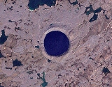
The Pingualuit Crater (French
: cratère des Pingualuit; Inuktitut
, "where the land rises"), formerly called Chubb Crater and later New Quebec Crater (cratère du Nouveau-Québec), is a young impact crater
, by geological standards, located in the Ungava Peninsula
of Quebec
, Canada. It is 3.44 km (2.1 mi) in diameter, and is estimated to be 1.4 ± 0.1 million years old (Pleistocene
).
The crater is exposed to the surface, rising 160 m (524.9 ft) above the surrounding tundra
and is 400 m (1,312.3 ft) deep. A 252 m (826.8 ft) deep Pingualuk Lake fills the depression, and is one of the deepest lakes in North America. The lake also holds some of the purest fresh water in the world, with a salinity level of less than 3 ppm (the salinity level of the Great Lakes
is 500 ppm). The lake has no inlets or apparent outlets, so the water accumulates solely from rain and snow and is only lost through evaporation. In terms of transparency, it is second only to Lake Mashū
in Japan.
who knew it as the "Crystal Eye of Nunavik" for its clear water. World War II pilots often used the perfectly circular landmark as a navigational tool.
On June 20, 1943, a United States Army Air Force
plane on a meteorological flight over the Ungava region of Quebec Province took a photograph which showed the wide crater rim rising up above the landscape. In 1948 the Royal Canadian Air Force
covered the same remote area as part of its program of photomapping Canada, however these photographs were not made publicly available until 1950.
In 1950 Ontario diamond prospector Frederick W. Chubb became interested by the strange terrain shown in the photographs and sought the opinion of geologist V. Ben Meen of the Royal Ontario Museum
. Chubb hoped that the crater was that of an extinct volcano, in which case the area might contain diamond deposits similar to those of South Africa. However, Meen's knowledge of Canadian geology tentatively ruled out a volcanic origin. Meen subsequently made a brief trip by air to the crater with Chubb in 1950; it was on this trip that Meen proposed the name "Chubb Crater" for the circular feature and "Museum Lake" for the irregular body of water about 2 mi (3.2 km) north of the crater (curr. Laflamme Lake).
Following his return, Meen organized a proper expedition with the cooperation of the National Geographic Society
and the Royal Ontario Museum, which travelled to the site in a PBY Catalina
flying boat
in July 1951, which enabled them to land on nearby Museum Lake. Attempts to find fragments of nickel-iron from the meteorite using mine detectors loaned by the US Army were unsuccessful, due to the area's granite containing high levels of magnetite
. However, a magnetometer
survey found a magnetic anomaly under the crater's northern rim, indicating that a large mass of metal-bearing material was buried below the surface.
Meen led a second expedition to the crater in 1954. That same year its name was changed to "Cratère du Nouveau-Quebec" ("New Quebec Crater") at the request of the Quebec Geographic Board. In 1999, the name was again changed, to "Pingualuit". The crater and the surrounding area are now part of Pingualuit National Park
.
, algae
, and insect larvae. It was hoped that these finds would yield information about climate change dating back to the last interglacial period
120,000 years ago.
French language
French is a Romance language spoken as a first language in France, the Romandy region in Switzerland, Wallonia and Brussels in Belgium, Monaco, the regions of Quebec and Acadia in Canada, and by various communities elsewhere. Second-language speakers of French are distributed throughout many parts...
: cratère des Pingualuit; Inuktitut
Inuktitut
Inuktitut or Eastern Canadian Inuktitut, Eastern Canadian Inuit language is the name of some of the Inuit languages spoken in Canada...
, "where the land rises"), formerly called Chubb Crater and later New Quebec Crater (cratère du Nouveau-Québec), is a young impact crater
Impact crater
In the broadest sense, the term impact crater can be applied to any depression, natural or manmade, resulting from the high velocity impact of a projectile with a larger body...
, by geological standards, located in the Ungava Peninsula
Ungava Peninsula
The Ungava Peninsula of Nunavik, Quebec, Canada, is bounded by Hudson Bay to the west, Hudson Strait to the north, and Ungava Bay to the east. The Ungava Peninsula is part of the Labrador Peninsula and covers about 252,000 km²...
of Quebec
Quebec
Quebec or is a province in east-central Canada. It is the only Canadian province with a predominantly French-speaking population and the only one whose sole official language is French at the provincial level....
, Canada. It is 3.44 km (2.1 mi) in diameter, and is estimated to be 1.4 ± 0.1 million years old (Pleistocene
Pleistocene
The Pleistocene is the epoch from 2,588,000 to 11,700 years BP that spans the world's recent period of repeated glaciations. The name pleistocene is derived from the Greek and ....
).
The crater is exposed to the surface, rising 160 m (524.9 ft) above the surrounding tundra
Tundra
In physical geography, tundra is a biome where the tree growth is hindered by low temperatures and short growing seasons. The term tundra comes through Russian тундра from the Kildin Sami word tūndâr "uplands," "treeless mountain tract." There are three types of tundra: Arctic tundra, alpine...
and is 400 m (1,312.3 ft) deep. A 252 m (826.8 ft) deep Pingualuk Lake fills the depression, and is one of the deepest lakes in North America. The lake also holds some of the purest fresh water in the world, with a salinity level of less than 3 ppm (the salinity level of the Great Lakes
Great Lakes
The Great Lakes are a collection of freshwater lakes located in northeastern North America, on the Canada – United States border. Consisting of Lakes Superior, Michigan, Huron, Erie, and Ontario, they form the largest group of freshwater lakes on Earth by total surface, coming in second by volume...
is 500 ppm). The lake has no inlets or apparent outlets, so the water accumulates solely from rain and snow and is only lost through evaporation. In terms of transparency, it is second only to Lake Mashū
Lake Mashu
is a landlocked endorheic crater lake formed in the caldera of a potentially active volcano. It is located in Akan National Park on the island of Hokkaidō, Japan. The lake has been called the clearest lake in the world.-Hydrology:...
in Japan.
Discovery
Largely unknown to the outside world, the lake-filled crater had long been known to local InuitInuit
The Inuit are a group of culturally similar indigenous peoples inhabiting the Arctic regions of Canada , Denmark , Russia and the United States . Inuit means “the people” in the Inuktitut language...
who knew it as the "Crystal Eye of Nunavik" for its clear water. World War II pilots often used the perfectly circular landmark as a navigational tool.
On June 20, 1943, a United States Army Air Force
United States Army Air Forces
The United States Army Air Forces was the military aviation arm of the United States of America during and immediately after World War II, and the direct predecessor of the United States Air Force....
plane on a meteorological flight over the Ungava region of Quebec Province took a photograph which showed the wide crater rim rising up above the landscape. In 1948 the Royal Canadian Air Force
Royal Canadian Air Force
The history of the Royal Canadian Air Force begins in 1920, when the air force was created as the Canadian Air Force . In 1924 the CAF was renamed the Royal Canadian Air Force and granted royal sanction by King George V. The RCAF existed as an independent service until 1968...
covered the same remote area as part of its program of photomapping Canada, however these photographs were not made publicly available until 1950.
In 1950 Ontario diamond prospector Frederick W. Chubb became interested by the strange terrain shown in the photographs and sought the opinion of geologist V. Ben Meen of the Royal Ontario Museum
Royal Ontario Museum
The Royal Ontario Museum is a museum of world culture and natural history in Toronto, Ontario, Canada. With its main entrance facing Bloor Street in Downtown Toronto, the museum is situated north of Queen's Park and east of Philosopher's Walk in the University of Toronto...
. Chubb hoped that the crater was that of an extinct volcano, in which case the area might contain diamond deposits similar to those of South Africa. However, Meen's knowledge of Canadian geology tentatively ruled out a volcanic origin. Meen subsequently made a brief trip by air to the crater with Chubb in 1950; it was on this trip that Meen proposed the name "Chubb Crater" for the circular feature and "Museum Lake" for the irregular body of water about 2 mi (3.2 km) north of the crater (curr. Laflamme Lake).
Following his return, Meen organized a proper expedition with the cooperation of the National Geographic Society
National Geographic Society
The National Geographic Society , headquartered in Washington, D.C. in the United States, is one of the largest non-profit scientific and educational institutions in the world. Its interests include geography, archaeology and natural science, the promotion of environmental and historical...
and the Royal Ontario Museum, which travelled to the site in a PBY Catalina
PBY Catalina
The Consolidated PBY Catalina was an American flying boat of the 1930s and 1940s produced by Consolidated Aircraft. It was one of the most widely used multi-role aircraft of World War II. PBYs served with every branch of the United States Armed Forces and in the air forces and navies of many other...
flying boat
Flying boat
A flying boat is a fixed-winged seaplane with a hull, allowing it to land on water. It differs from a float plane as it uses a purpose-designed fuselage which can float, granting the aircraft buoyancy. Flying boats may be stabilized by under-wing floats or by wing-like projections from the fuselage...
in July 1951, which enabled them to land on nearby Museum Lake. Attempts to find fragments of nickel-iron from the meteorite using mine detectors loaned by the US Army were unsuccessful, due to the area's granite containing high levels of magnetite
Magnetite
Magnetite is a ferrimagnetic mineral with chemical formula Fe3O4, one of several iron oxides and a member of the spinel group. The chemical IUPAC name is iron oxide and the common chemical name is ferrous-ferric oxide. The formula for magnetite may also be written as FeO·Fe2O3, which is one part...
. However, a magnetometer
Magnetometer
A magnetometer is a measuring instrument used to measure the strength or direction of a magnetic field either produced in the laboratory or existing in nature...
survey found a magnetic anomaly under the crater's northern rim, indicating that a large mass of metal-bearing material was buried below the surface.
Meen led a second expedition to the crater in 1954. That same year its name was changed to "Cratère du Nouveau-Quebec" ("New Quebec Crater") at the request of the Quebec Geographic Board. In 1999, the name was again changed, to "Pingualuit". The crater and the surrounding area are now part of Pingualuit National Park
Pingualuit National Park
Pingualuit National Park is a 1,133.90 km² provincial park located in the Ungava Peninsula south-east of the inuit village of Kangiqsujuaq. The park protects the Pingualuit crater, a young meteorite crater....
.
2007 expedition
Professor Reinhard Pienitz of Laval University led a 2007 expedition to the crater which extracted sediment cores from the bottom of the lake which were filled with fossil pollenPollen
Pollen is a fine to coarse powder containing the microgametophytes of seed plants, which produce the male gametes . Pollen grains have a hard coat that protects the sperm cells during the process of their movement from the stamens to the pistil of flowering plants or from the male cone to the...
, algae
Algae
Algae are a large and diverse group of simple, typically autotrophic organisms, ranging from unicellular to multicellular forms, such as the giant kelps that grow to 65 meters in length. They are photosynthetic like plants, and "simple" because their tissues are not organized into the many...
, and insect larvae. It was hoped that these finds would yield information about climate change dating back to the last interglacial period
Interglacial
An Interglacial period is a geological interval of warmer global average temperature lasting thousands of years that separates consecutive glacial periods within an ice age...
120,000 years ago.