
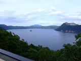
Lake Mashu
Encyclopedia
is a landlocked
endorheic
crater lake
formed in the caldera
of a potentially active volcano. It is located in Akan National Park
on the island of Hokkaidō
, Japan
. The lake has been called the clearest lake in the world.
was measured around the same time measured 40.5 metres (132.9 ft). This is the lake's claim to clearest in the world. Since the 1950s the transparency has tended to range between 20 and 30 m (65.6 and 98.4 ft). The loss in transparency is probably due to the introduction of sockeye salmon
and rainbow trout
into the lake. At the same time, the clarity of Lake Baikal has not been measured.
In summer, the surface of Lake Mashū is often obscured by fog. This have given the lake a reputation for mysteriousness. Local legend says that if you can see the surface of the lake, you will have bad luck.
. This was rendered as by the Japanese. Over time, however, the Japanese began to refer to the lake by the Japanese reading for the neighboring peak, . The kanji
for this peak translate roughly as scrubbed area mountain. The Ainu name for this peak, by which it is commonly known today, is Kamuinupuri or mountain of the gods. The lake also retains its Ainu name, Kamuito or lake of the gods.
, which is actually a parasitic cone of the larger Lake Kussharo
caldera. The eruption that created the current caldera occurred around 7,000 years ago. The last eruption was a plinian eruption
about 2,000 years ago that dropped pumice
over the region.
Mashū volcano is rated with a Volcanic Explosivity Index
of 6, the second highest among large volcanoes.
Two volcanoes have grown out of the Mashū caldera. Kamuishu Island, a lava dome
which rises from the middle of the lake, is one. The other is Mount Kamui
, a stratovolcano with lava dome
, which forms the highest point on the eastern shore. A third volcano neighbors Kamuinupuri. It is Mount Nishibetsu. Mount Nishibetsu probably predates the caldera.
The main rock type of the volcanoes is andesite
and dacite
. The rock is non-alkali pyroclastic flow
or mafic rock, dating from the Late Pleistocene
to the Holocene
. Some rock around the Mashū crater and Mount Nishibetsu is older still, dating from the Middle Pleistocene
.
The following table lists the eruptions of the Mashū volcano and Kamuinupuri.
Sockeye salmon
and rainbow trout
have been introduced to the lake.
On the slopes around and above the lake grow a mixture of evergreen forest with Picea jezoensis and Abies sachalinensis
and birch forest with Betula ermanii
.
. Visitors may only view the lake from the designated observation towers.
Landlocked
A landlocked country is a country entirely enclosed by land, or whose only coastlines lie on closed seas. There are 48 landlocked countries in the world, including partially recognized states...
endorheic
Endorheic
An endorheic basin is a closed drainage basin that retains water and allows no outflow to other bodies of water such as rivers or oceans...
crater lake
Crater lake
A crater lake is a lake that forms in a volcanic crater or caldera, such as a maar; less commonly and with lower association to the term a lake may form in an impact crater caused by a meteorite. Sometimes lakes which form inside calderas are called caldera lakes, but often this distinction is not...
formed in the caldera
Caldera
A caldera is a cauldron-like volcanic feature usually formed by the collapse of land following a volcanic eruption, such as the one at Yellowstone National Park in the US. They are sometimes confused with volcanic craters...
of a potentially active volcano. It is located in Akan National Park
Akan National Park
is a national park located on the island of Hokkaidō, Japan. Along with Daisetsuzan National Park, these are the two oldest national parks in Hokkaidō. The park was established December 4, 1934....
on the island of Hokkaidō
Hokkaido
, formerly known as Ezo, Yezo, Yeso, or Yesso, is Japan's second largest island; it is also the largest and northernmost of Japan's 47 prefectural-level subdivisions. The Tsugaru Strait separates Hokkaido from Honshu, although the two islands are connected by the underwater railway Seikan Tunnel...
, Japan
Japan
Japan is an island nation in East Asia. Located in the Pacific Ocean, it lies to the east of the Sea of Japan, China, North Korea, South Korea and Russia, stretching from the Sea of Okhotsk in the north to the East China Sea and Taiwan in the south...
. The lake has been called the clearest lake in the world.
Hydrology
Lake Mashū is surrounded by steep crater walls 200 metres (656.2 ft) high. It has no significant inlets and no outlet. The lake is one of the clearest in the world and one of the deepest in Japan. On August 1, 1931 the transparency of the water was measured at 41.6 metres (136.5 ft). Lake BaikalLake Baikal
Lake Baikal is the world's oldest at 30 million years old and deepest lake with an average depth of 744.4 metres.Located in the south of the Russian region of Siberia, between Irkutsk Oblast to the northwest and the Buryat Republic to the southeast, it is the most voluminous freshwater lake in the...
was measured around the same time measured 40.5 metres (132.9 ft). This is the lake's claim to clearest in the world. Since the 1950s the transparency has tended to range between 20 and 30 m (65.6 and 98.4 ft). The loss in transparency is probably due to the introduction of sockeye salmon
Sockeye salmon
Sockeye salmon , also called red salmon or blueback salmon in the USA, is an anadromous species of salmon found in the Northern Pacific Ocean and rivers discharging into it...
and rainbow trout
Rainbow trout
The rainbow trout is a species of salmonid native to tributaries of the Pacific Ocean in Asia and North America. The steelhead is a sea run rainbow trout usually returning to freshwater to spawn after 2 to 3 years at sea. In other words, rainbow trout and steelhead trout are the same species....
into the lake. At the same time, the clarity of Lake Baikal has not been measured.
In summer, the surface of Lake Mashū is often obscured by fog. This have given the lake a reputation for mysteriousness. Local legend says that if you can see the surface of the lake, you will have bad luck.
Origin of the name
Lake Mashū was originally named Lake of the Devil by the AinuAinu people
The , also called Aynu, Aino , and in historical texts Ezo , are indigenous people or groups in Japan and Russia. Historically they spoke the Ainu language and related varieties and lived in Hokkaidō, the Kuril Islands, and much of Sakhalin...
. This was rendered as by the Japanese. Over time, however, the Japanese began to refer to the lake by the Japanese reading for the neighboring peak, . The kanji
Kanji
Kanji are the adopted logographic Chinese characters hanzi that are used in the modern Japanese writing system along with hiragana , katakana , Indo Arabic numerals, and the occasional use of the Latin alphabet...
for this peak translate roughly as scrubbed area mountain. The Ainu name for this peak, by which it is commonly known today, is Kamuinupuri or mountain of the gods. The lake also retains its Ainu name, Kamuito or lake of the gods.
Volcanic caldera
Mashū formed less than 32,000 years ago. The caldera is the remains of a stratovolcanoStratovolcano
A stratovolcano, also known as a composite volcano, is a tall, conical volcano built up by many layers of hardened lava, tephra, pumice, and volcanic ash. Unlike shield volcanoes, stratovolcanoes are characterized by a steep profile and periodic, explosive eruptions...
, which is actually a parasitic cone of the larger Lake Kussharo
Lake Kussharo
is a caldera lake in Akan National Park, eastern Hokkaidō, Japan. As with many geographic names in Hokkaidō, the name derives from the Ainu language. It is the largest caldera lake in Japan in terms of surface area, and sixth largest lake in Japan. It is also the largest lake in Japan to freeze...
caldera. The eruption that created the current caldera occurred around 7,000 years ago. The last eruption was a plinian eruption
Plinian eruption
Plinian eruptions, also known as 'Vesuvian eruptions', are volcanic eruptions marked by their similarity to the eruption of Mount Vesuvius in AD 79 ....
about 2,000 years ago that dropped pumice
Pumice
Pumice is a textural term for a volcanic rock that is a solidified frothy lava typically created when super-heated, highly pressurized rock is violently ejected from a volcano. It can be formed when lava and water are mixed. This unusual formation is due to the simultaneous actions of rapid...
over the region.
Mashū volcano is rated with a Volcanic Explosivity Index
Volcanic Explosivity Index
The Volcanic Explosivity Index was devised by Chris Newhall of the U.S. Geological Survey and Stephen Self at the University of Hawaii in 1982 to provide a relative measure of the explosiveness of volcanic eruptions....
of 6, the second highest among large volcanoes.
Two volcanoes have grown out of the Mashū caldera. Kamuishu Island, a lava dome
Lava dome
|250px|thumb|right|Image of the [[rhyolitic]] lava dome of [[Chaitén Volcano]] during its 2008–2009 eruption.In volcanology, a lava dome is a roughly circular mound-shaped protrusion resulting from the slow extrusion of viscous lava from a volcano...
which rises from the middle of the lake, is one. The other is Mount Kamui
Mount Kamui (Lake Mashu caldera)
, also Kamuinupuri or Mount Mashū, a potentially active volcano, is a parasitic stratovolcano of the Mashū caldera located in the Akan National Park of Hokkaido, Japan.-Volcanism:...
, a stratovolcano with lava dome
Lava dome
|250px|thumb|right|Image of the [[rhyolitic]] lava dome of [[Chaitén Volcano]] during its 2008–2009 eruption.In volcanology, a lava dome is a roughly circular mound-shaped protrusion resulting from the slow extrusion of viscous lava from a volcano...
, which forms the highest point on the eastern shore. A third volcano neighbors Kamuinupuri. It is Mount Nishibetsu. Mount Nishibetsu probably predates the caldera.
The main rock type of the volcanoes is andesite
Andesite
Andesite is an extrusive igneous, volcanic rock, of intermediate composition, with aphanitic to porphyritic texture. In a general sense, it is the intermediate type between basalt and dacite. The mineral assemblage is typically dominated by plagioclase plus pyroxene and/or hornblende. Magnetite,...
and dacite
Dacite
Dacite is an igneous, volcanic rock. It has an aphanitic to porphyritic texture and is intermediate in composition between andesite and rhyolite. The relative proportions of feldspars and quartz in dacite, and in many other volcanic rocks, are illustrated in the QAPF diagram...
. The rock is non-alkali pyroclastic flow
Pyroclastic flow
A pyroclastic flow is a fast-moving current of superheated gas and rock , which reaches speeds moving away from a volcano of up to 700 km/h . The flows normally hug the ground and travel downhill, or spread laterally under gravity...
or mafic rock, dating from the Late Pleistocene
Late Pleistocene
The Late Pleistocene is a stage of the Pleistocene Epoch. The beginning of the stage is defined by the base of the Eemian interglacial phase before the final glacial episode of the Pleistocene 126,000 ± 5,000 years ago. The end of the stage is defined exactly at 10,000 Carbon-14 years BP...
to the Holocene
Holocene
The Holocene is a geological epoch which began at the end of the Pleistocene and continues to the present. The Holocene is part of the Quaternary period. Its name comes from the Greek words and , meaning "entirely recent"...
. Some rock around the Mashū crater and Mount Nishibetsu is older still, dating from the Middle Pleistocene
Middle Pleistocene
The Middle Pleistocene, more specifically referred to as the Ionian stage, is a period of geologic time from ca. 781 to 126 thousand years ago....
.
The following table lists the eruptions of the Mashū volcano and Kamuinupuri.
| Volcano | Date of eruption | Dating technique | VEI | Tephra volume | Type |
|---|---|---|---|---|---|
| Mashū | 7400 BC ± 200 years | Corrected radiocarbon | 4 | 440000000 cubic metre (0.105561613785886 cu mi) | Explosive eruption |
| Mashū | 6600 BC ± 50 years | Corrected radiocarbon | 6 | 11000000000 cubic metres (2.6 cu mi) | Explosive eruption of the central vent with pyroclastic flow and caldera collapse |
| Mount Kamui | 2750 BC ± 100 years | Corrected radiocarbon | Explosive eruption of a flank vent | ||
| Mount Kamui | 1400 BC ± 100 years | Corrected radiocarbon | Explosive eruption of a flank vent | ||
| Mount Kamui | 100 BC ± 500 years | Tephrochronology Tephrochronology 250px|thumb|right|Tephra horizons in south-central [[Iceland]]. The thick and light coloured layer at the height of the [[volcanologists]] hands is [[rhyolitic]] [[tephra]] from [[Hekla]].... |
Explosive eruption | ||
| Mount Kamui | 300 AD ± 75 years | Corrected radiocarbon | Explosive eruption | ||
| Mount Kamui | 970 AD ± 100 years | Uncorrected radiocarbon | 5 | 1000000000 cubic metre (0.239912758604287 cu mi) | Explosive eruption of a flank vent and caldera collapse |
Flora and fauna
The lake is inhabited by phytoplankton and zooplankton.- Melosira spp.CentralesCoscinodiscophyceae is a class of diatom.Coscinodiscophyceae is similar to Centrales. Order Centrales is a traditional, paraphyletic subdivision of the heterokont algae known as diatoms. The order is named for the shape of the cell walls of centric diatoms, which are circular or ellipsoid in...
- Synedra sp.PennalesOrder Pennales is a traditional subdivision of the heterokont algae known as diatoms. The order is named for the shape of the cell walls of pennate diatoms, which are elongated in valve view. The valves may be linear or oval in shape, and usually bear bilaterally symmetrical ornamental patterns...
- Daphnia longispinaDaphniaDaphnia are small, planktonic crustaceans, between 0.2 and 5 mm in length. Daphnia are members of the order Cladocera, and are one of the several small aquatic crustaceans commonly called water fleas because of their saltatory swimming style...
- Bosmina coregoniBosminaBosmina is a genus in the order Cladocera. Its members can be distinguished from those of Bosminopsis by the separation of the antennae; in Bosminopsis, the antennae are fused at their bases....
Sockeye salmon
Sockeye salmon
Sockeye salmon , also called red salmon or blueback salmon in the USA, is an anadromous species of salmon found in the Northern Pacific Ocean and rivers discharging into it...
and rainbow trout
Rainbow trout
The rainbow trout is a species of salmonid native to tributaries of the Pacific Ocean in Asia and North America. The steelhead is a sea run rainbow trout usually returning to freshwater to spawn after 2 to 3 years at sea. In other words, rainbow trout and steelhead trout are the same species....
have been introduced to the lake.
On the slopes around and above the lake grow a mixture of evergreen forest with Picea jezoensis and Abies sachalinensis
Abies sachalinensis
Abies sachalinensis is a species of conifer in the family Pinaceae. It is found in Sakhalin island and southern Kurils , and also in northern Hokkaido ....
and birch forest with Betula ermanii
Betula ermanii
Betula ermanii, or Erman's Birch, is a tree species belonging to the family Betulaceae. It is an extremely variable species and can be found in Japan, Kuriles, Sakhalin, Kamchatka, and Korea. It can grow to be 20 m tall...
.
Economy
The Mashu-dake Hiking Course is a trail that goes along the crater rim and to the top of Mount Mashū. There are no settlements along the shores of the lake. Access to the lakeshore itself is prohibited by the Ministry of the Environment (Japan)Ministry of the Environment (Japan)
The ' of Japan was formed in 2001 from the sub-cabinet level Environmental Agency established in 1971. The minister is a member of the Cabinet and is chosen by the Prime Minister, usually from the Diet., the current is Goshi Hosono...
. Visitors may only view the lake from the designated observation towers.
External links
- 摩周湖, Teshikaga Town (In Japanese)
- GEMS/Water 摩周湖モニタリングデータブック, Center for Global Environmental Research (In Japanese)