

New Point Comfort
Encyclopedia
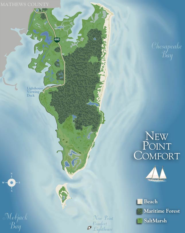
New Point Comfort is a point of land located in Mathews County
at the tip of Virginia
's Middle Peninsula
in the lower Chesapeake Bay
in the United States
. It is the site of the New Point Comfort Natural Area Preserve
and the New Point Comfort Light
.
at the mouth of Mobjack Bay
. It is 21 miles (34 km) north of Old Point Comfort
in Phoebus
, Hampton
. The peninsula
to the north of the point, from Peppers Creek and Horn Harbor southward, is also called New Point Comfort.
explorer
John Smith
passed by New Point Comfort in 1608 when returning to Jamestown
from the northern Chesapeake Bay. The New Point Comfort Light
was built from 1802-1805 and, by 1852, it was partially cut off by the sea and formed a new island. In 1904, the New Point Comfort Development Company was formed to build a resort
on the peninsula by reclaiming
the marsh
that separated the lighthouse from the mainland and building beach
es. However, the prohibitive cost doomed the project and the business went bankrupt
. In 1933, the Chesapeake Potomac Hurricane
and the Outer Banks Hurricane definitively severed the lighthouse from the mainland and it now is about one half mile (0.8 km) from shore on a small riprap
island.
Mathews County, Virginia
As of the census of 2010, there were 8,978 people, 3,932 households, and 2,823 families residing in the county. The population density was 108 people per square mile . There were 5,333 housing units at an average density of 62 per square mile...
at the tip of Virginia
Virginia
The Commonwealth of Virginia , is a U.S. state on the Atlantic Coast of the Southern United States. Virginia is nicknamed the "Old Dominion" and sometimes the "Mother of Presidents" after the eight U.S. presidents born there...
's Middle Peninsula
Middle Peninsula
The Middle Peninsula is the second of three large peninsulas on the western shore of Chesapeake Bay in Virginia, in the United States. It lies between the Northern Neck and the Virginia Peninsula. This peninsula is bounded by the Rappahannock River on the north and the York River on the south...
in the lower Chesapeake Bay
Chesapeake Bay
The Chesapeake Bay is the largest estuary in the United States. It lies off the Atlantic Ocean, surrounded by Maryland and Virginia. The Chesapeake Bay's drainage basin covers in the District of Columbia and parts of six states: New York, Pennsylvania, Delaware, Maryland, Virginia, and West...
in the United States
United States
The United States of America is a federal constitutional republic comprising fifty states and a federal district...
. It is the site of the New Point Comfort Natural Area Preserve
New Point Comfort Natural Area Preserve
New Point Comfort Natural Area Preserve is a Natural Area Preserve located in Mathews County, Virginia. It is located along the Atlantic Flyway, and consequently provides habitat for nesting and breeding, both during the migration season and at other times throughout the year; among the birds that...
and the New Point Comfort Light
New Point Comfort Light
New Point Comfort Light is a lighthouse in the Virginia portion of the Chesapeake Bay. It is the third oldest surviving light in the bay, and the tenth oldest in the United states.-History:...
.
Geography
The tip New Point Comfort is now on an island separated from the mainland of Mathews County south of the unincorporated town of BavonBavon, Virginia
Bavon is an unincorporated community in Mathews County, Virginia, United States. Bavon is located on Virginia Route 14 south-southeast of Mathews....
at the mouth of Mobjack Bay
Mobjack Bay
Mobjack Bay is a bay on the western shore of Chesapeake Bay in Virginia in the United States. It lies between the York River on the south and the Rappahannock River on the north....
. It is 21 miles (34 km) north of Old Point Comfort
Old Point Comfort
Old Point Comfort is a point of land located in the independent city of Hampton. It lies at the extreme tip of the Virginia Peninsula at the mouth of Hampton Roads in the United States....
in Phoebus
Phoebus, Virginia
Phoebus was an incorporated town located in Elizabeth City County on the Virginia Peninsula in eastern Virginia. Upon incorporation in 1900, it was named in honor of local businessman Harrison Phoebus , who is credited with convincing the Chesapeake and Ohio Railway to extend its tracks to the...
, Hampton
Hampton, Virginia
Hampton is an independent city that is not part of any county in Southeast Virginia. Its population is 137,436. As one of the seven major cities that compose the Hampton Roads metropolitan area, it is on the southeastern end of the Virginia Peninsula. Located on the Hampton Roads Beltway, it hosts...
. The peninsula
Peninsula
A peninsula is a piece of land that is bordered by water on three sides but connected to mainland. In many Germanic and Celtic languages and also in Baltic, Slavic and Hungarian, peninsulas are called "half-islands"....
to the north of the point, from Peppers Creek and Horn Harbor southward, is also called New Point Comfort.
History
EnglishEngland
England is a country that is part of the United Kingdom. It shares land borders with Scotland to the north and Wales to the west; the Irish Sea is to the north west, the Celtic Sea to the south west, with the North Sea to the east and the English Channel to the south separating it from continental...
explorer
Exploration
Exploration is the act of searching or traveling around a terrain for the purpose of discovery of resources or information. Exploration occurs in all non-sessile animal species, including humans...
John Smith
John Smith of Jamestown
Captain John Smith Admiral of New England was an English soldier, explorer, and author. He was knighted for his services to Sigismund Bathory, Prince of Transylvania and friend Mózes Székely...
passed by New Point Comfort in 1608 when returning to Jamestown
Jamestown, Virginia
Jamestown was a settlement in the Colony of Virginia. Established by the Virginia Company of London as "James Fort" on May 14, 1607 , it was the first permanent English settlement in what is now the United States, following several earlier failed attempts, including the Lost Colony of Roanoke...
from the northern Chesapeake Bay. The New Point Comfort Light
New Point Comfort Light
New Point Comfort Light is a lighthouse in the Virginia portion of the Chesapeake Bay. It is the third oldest surviving light in the bay, and the tenth oldest in the United states.-History:...
was built from 1802-1805 and, by 1852, it was partially cut off by the sea and formed a new island. In 1904, the New Point Comfort Development Company was formed to build a resort
Resort
A resort is a place used for relaxation or recreation, attracting visitors for holidays or vacations. Resorts are places, towns or sometimes commercial establishment operated by a single company....
on the peninsula by reclaiming
Land reclamation
Land reclamation, usually known as reclamation, is the process to create new land from sea or riverbeds. The land reclaimed is known as reclamation ground or landfill.- Habitation :...
the marsh
Marsh
In geography, a marsh, or morass, is a type of wetland that is subject to frequent or continuous flood. Typically the water is shallow and features grasses, rushes, reeds, typhas, sedges, other herbaceous plants, and moss....
that separated the lighthouse from the mainland and building beach
Beach
A beach is a geological landform along the shoreline of an ocean, sea, lake or river. It usually consists of loose particles which are often composed of rock, such as sand, gravel, shingle, pebbles or cobblestones...
es. However, the prohibitive cost doomed the project and the business went bankrupt
Bankruptcy
Bankruptcy is a legal status of an insolvent person or an organisation, that is, one that cannot repay the debts owed to creditors. In most jurisdictions bankruptcy is imposed by a court order, often initiated by the debtor....
. In 1933, the Chesapeake Potomac Hurricane
1933 Chesapeake Potomac Hurricane
The 1933 Chesapeake-Potomac Hurricane was the eighth storm and third hurricane of the very active 1933 Atlantic hurricane season. The August storm formed in the central Atlantic, where it moved west-northwest...
and the Outer Banks Hurricane definitively severed the lighthouse from the mainland and it now is about one half mile (0.8 km) from shore on a small riprap
Riprap
Riprap — also known as rip rap, rubble, shot rock or rock armour or "Rip-rap" — is rock or other material used to armor shorelines, streambeds, bridge abutments, pilings and other shoreline structures against scour, water or ice erosion.It is made from a variety of rock types, commonly granite or...
island.