
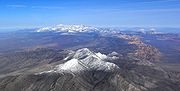
Spring Mountains
Encyclopedia
Mountain range
A mountain range is a single, large mass consisting of a succession of mountains or narrowly spaced mountain ridges, with or without peaks, closely related in position, direction, formation, and age; a component part of a mountain system or of a mountain chain...
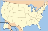
of southern Nevada
Nevada
Nevada is a state in the western, mountain west, and southwestern regions of the United States. With an area of and a population of about 2.7 million, it is the 7th-largest and 35th-most populous state. Over two-thirds of Nevada's people live in the Las Vegas metropolitan area, which contains its...
in the United States
United States
The United States of America is a federal constitutional republic comprising fifty states and a federal district...
, running generally northwest-southeast along the west side of Las Vegas
Las Vegas, Nevada
Las Vegas is the most populous city in the U.S. state of Nevada and is also the county seat of Clark County, Nevada. Las Vegas is an internationally renowned major resort city for gambling, shopping, and fine dining. The city bills itself as The Entertainment Capital of the World, and is famous...
and down to the border with California
California
California is a state located on the West Coast of the United States. It is by far the most populous U.S. state, and the third-largest by land area...
. Most land in the mountains is owned by the United States Forest Service
United States Forest Service
The United States Forest Service is an agency of the United States Department of Agriculture that administers the nation's 155 national forests and 20 national grasslands, which encompass...
and the Bureau of Land Management
Bureau of Land Management
The Bureau of Land Management is an agency within the United States Department of the Interior which administers America's public lands, totaling approximately , or one-eighth of the landmass of the country. The BLM also manages of subsurface mineral estate underlying federal, state and private...
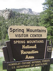
and managed as the Spring Mountains National Recreation Area
Spring Mountains National Recreation Area
The Spring Mountains National Recreation Area is a U.S. National Recreation Area, administered by the U.S. Forest Service, and lies west of Las Vegas, Nevada. It covers over 316,000 acres of land. The area runs from low meadows at around 3,000 feet of elevation to Mount Charleston at 11,918...
and Red Rock Canyon National Conservation Area
Red Rock Canyon National Conservation Area
Red Rock Canyon National Conservation Area in Nevada is an area managed by the Bureau of Land Management as part of its National Landscape Conservation System, and protected as a National Conservation Area. It is located about west of Las Vegas, and easily seen from the Las Vegas Strip...
within the Humboldt-Toiyabe National Forest
Humboldt-Toiyabe National Forest
The Humboldt-Toiyabe National Forest is the principal U.S. National Forest located in the U.S. state of Nevada. With an area of , it is the largest National Forest of the United States outside of Alaska...
.
Geography
The Spring Mountains range is named for the number of springSpring (hydrosphere)
A spring—also known as a rising or resurgence—is a component of the hydrosphere. Specifically, it is any natural situation where water flows to the surface of the earth from underground...
s to be found, many of them in the recesses of Red Rock
Red Rock Canyon National Conservation Area
Red Rock Canyon National Conservation Area in Nevada is an area managed by the Bureau of Land Management as part of its National Landscape Conservation System, and protected as a National Conservation Area. It is located about west of Las Vegas, and easily seen from the Las Vegas Strip...
, which is on the eastern side of the mountains. The Spring Mountains divide the Pahrump Valley
Pahrump Valley
Pahrump Valley is a Mojave Desert valley west of Las Vegas and the Spring Mountains massif in southern Nye County, Nevada, and eastern San Bernardino County, California. Pahrump, Nevada, is in the valley's center and the Tecopa and Chicago Valleys are immediately to the west...
and Amargosa River
Amargosa River
The Amargosa River is an intermittent waterway, long, in southern Nevada and eastern California in the United States. It drains a high desert region, the Amargosa Valley in the Amargosa Desert northwest of Las Vegas, into the Mojave Desert, and finally into Death Valley where it disappears into...
basins from the Las Vegas Valley
Las Vegas metropolitan area
The Las Vegas Valley is the heart of the Las Vegas-Paradise, NV MSA also known as the Las Vegas–Paradise–Henderson MSA which includes all of Clark County, Nevada, and is a metropolitan area in the southern part of the U.S. state of Nevada. The Valley is defined by the Las Vegas Valley landform, a ...
watershed, which drains into the Colorado River watershed, by way of Las Vegas Wash
Las Vegas Wash
Las Vegas Wash is a 12 mile-long channel which feeds most of Las Vegas Valley's excess water into Lake Mead. The wash is sometimes called an urban river, and it exists in its present capacity because of an urban population. The wash also works in a systemic conjunction with the pre-existing...
into Lake Mead
Lake Mead
Lake Mead is the largest reservoir in the United States. It is located on the Colorado River about southeast of Las Vegas, Nevada, in the states of Nevada and Arizona. Formed by water impounded by the Hoover Dam, it extends behind the dam, holding approximately of water.-History:The lake was...
, thus the mountains define part of the boundary of the Great Basin
Great Basin
The Great Basin is the largest area of contiguous endorheic watersheds in North America and is noted for its arid conditions and Basin and Range topography that varies from the North American low point at Badwater Basin to the highest point of the contiguous United States, less than away at the...
. The Great Basin Divide
Great Basin Divide
The Great Basin Divide is the western continental divide that separates the Great Basin from the Pacific Ocean watershed. The water divide is the perimeter of the largest set of contiguous endorheic watersheds of North America, including six entire USGS watershed subregions...
, (one of the Great Basin region borders) continues north through the Indian Springs Pass
Indian Springs Pass
Indian Springs Pass, is a mountain pass 40-mi northwest of Las Vegas in northwest Clark County, Nevada.The pass is in a region of converging landforms of various watersheds, valleys, and mountain ranges; specifically it lies on the north perimeter of the Ivanpah-Pahrump Watershed-...
region then turns due east at the perimeter mountain ranges north of Las Vegas.
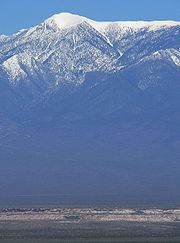
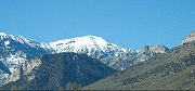
Mount Charleston
The highest point is Mount CharlestonMount Charleston
Mount Charleston, officially named Charleston Peak, at , is the highest of the Spring Mountains of southern Nevada and the state's eighth highest mountain peak. It is about northwest of Las Vegas and is within the Humboldt-Toiyabe National Forest, the Mount Charleston Wilderness and the Spring...
, at 11918 ft (3,632.6 m). The area around Mt. Charleston is protected in the Mount Charleston Wilderness. Typically 20-30 degrees Fahrenheit (11-17 degrees Celsius) cooler than the valleys below, the area is a popular getaway for Las Vegas residents and visitors; the Las Vegas Ski and Snowboard Resort
Las Vegas Ski and Snowboard Resort
The Las Vegas Ski and Snowboard Resort, also known to locals as Lee Canyon, is located in the Spring Mountains National Recreation Area, about 45 minutes' drive northwest of Las Vegas, Nevada via US 95. It is owned and operated by Powdr Corporation...
lies in Lee Canyon on State Highway 156.
Other Peaks
In addition to Mount Charleston, other major summits in the Spring Mountains range include Bonanza Peak, McFarland PeakMcFarland Peak
McFarland Peak is a limestone peak in the northern portion of the Spring Mountains in Clark County of southern Nevada. It is in the Toiyabe National Forest and the Mount Charleston Wilderness.McFarland Peak is located north of Mount Charleston....
, Mummy Mountain
Mummy Mountain (Nevada)
Mummy Mountain is the second highest peak of the Spring Mountains in Clark County of southern Nevada.It takes its name from its vague resemblance to a mummy, or perhaps more accurately an Egyptian sarcophagus seen in profile, with the "head" to the north formed by outcropping above Lee Canyon, the...
, Griffith Peak
Griffith Peak
Griffith Peak is located in the Spring Mountains in Clark County of southern Nevada. It is approximately northwest of the Las Vegas Strip and southeast of Mount Charleston.Griffith Peak is southern Nevada's third highest, Nevada's 43rd highest peak...
, Bridge Mountain
Bridge Mountain
Bridge Mountain is one of the mountains surrounding Red Rock Canyon in the Spring Mountains in Clark County of southern Nevada.Bridge Mountain is named for the natural feature of a bridge-like natural arch of sandstone near the summit. Bridge Mountain is highest peak in the Red Rock Canyon National...
, Mount Wilson
Mount Wilson (Nevada)
Mount Wilson is the second highest peak in the Red Rock Canyon National Conservation Area, in the Spring Mountains.Mount Wilson in Clark County of southern Nevada.- External links :...
, and Mount Potosi.
Biological diversity
The Spring Mountains are a sky islandSky island
Sky islands are mountains that are isolated by surrounding lowlands of a dramatically different environment, a situation which, in combination with the altitudinal zonation of ecosystems, has significant implications for natural habitats. Endemism, vertical migration, and relict populations are...
ecosystem
Ecosystem
An ecosystem is a biological environment consisting of all the organisms living in a particular area, as well as all the nonliving , physical components of the environment with which the organisms interact, such as air, soil, water and sunlight....
. With an area of about 860 square miles (2,227.4 km²), and a vertical range of nearly 2 miles (3.2 km), the mountains encompass a wide variety of habitats
Habitat (ecology)
A habitat is an ecological or environmental area that is inhabited by a particular species of animal, plant or other type of organism...
, and the biological diversity is probably greater than anywhere else in Nevada. 37 species of tree
Tree
A tree is a perennial woody plant. It is most often defined as a woody plant that has many secondary branches supported clear of the ground on a single main stem or trunk with clear apical dominance. A minimum height specification at maturity is cited by some authors, varying from 3 m to...
s are known (more than any other Nevadan range), and 600 species of vascular plant
Vascular plant
Vascular plants are those plants that have lignified tissues for conducting water, minerals, and photosynthetic products through the plant. Vascular plants include the clubmosses, Equisetum, ferns, gymnosperms and angiosperms...
s have been reported from the Red Rock Canyon National Conservation Area
Red Rock Canyon National Conservation Area
Red Rock Canyon National Conservation Area in Nevada is an area managed by the Bureau of Land Management as part of its National Landscape Conservation System, and protected as a National Conservation Area. It is located about west of Las Vegas, and easily seen from the Las Vegas Strip...
alone.
The bases of the mountains are part of the Mojave Zone
Mojave
Mojave or Mohave most often refers to:*Mojave Desert*Mojave River*Mohave peopleIt can also refer to:-Population Centers:* Mojave, California* Fort Mojave Indian Reservation* Mohave County, Arizona...
dominated by creosote bush
Creosote bush
Larrea tridentata is known as Creosote bush as a plant, chaparral as a medicinal herb, and as "gobernadora" in Mexico, Spanish for "governess," due to its ability for inhibiting the growth of nearby plants to have more water. In Sonora, it is more commonly called "hediondilla." It is a flowering...
and white bursage, then rising to a Blackbrush Zone, followed by a Pygmy Conifer Zone with juniper
Juniper
Junipers are coniferous plants in the genus Juniperus of the cypress family Cupressaceae. Depending on taxonomic viewpoint, there are between 50-67 species of juniper, widely distributed throughout the northern hemisphere, from the Arctic, south to tropical Africa in the Old World, and to the...
, pinyon pine
Pinyon pine
The pinyon pine group grows in the southwestern United States and in Mexico. The trees yield edible pinyon nuts, which were a staple of the Native Americans, and are still widely eaten...
and mountain-mahogany
Mountain-mahogany
Cercocarpus, commonly known as mountain mahogany, is a small genus of five or six species of deciduous shrubs or small trees in the rose family , native to the western United States and northern Mexico, where they grow in chaparral and semi-desert habitats and climates, often at high altitudes...
, and topped by a montane zone with many species of conifers around Mt. Charleston and its connecting ridges.
 |
 |