
Dollywaggon Pike
Encyclopedia
Dollywaggon Pike is a fell
in the English
Lake District
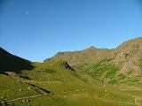
. It stands on the main spine of the Helvellyn range
in the Eastern Fells
, between Thirlmere
and the Ullswater
catchment.
1:25,000 maps but "Dollywagon" on 1:50,000 maps. The Ordnance Survey gazeteer, nominally based on the 1:50,000 maps, lists only "Dollywaggon Pike". As of 2005, the "Dollywagon" spelling is slightly more common in online references. Alfred Wainwright
used "Dollywaggon Pike" in his Pictorial Guide, a position supported by other writers.
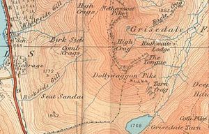 The Helvellyn range runs broadly north-south for about 7 miles, remaining above 2,000 ft (600 m) throughout its length. Dollywaggon Pike is the southernmost fell of the ridge proper, with Nethermost Pike
immediately to the north. There is a subsidiary top between Nethermost and Dollywaggon Pikes named High Crag (2,900 ft). Due to the very limited depression between the two, most guidebooks follow Wainwright in counting High Crag as a part of Nethermost Pike. To the south of Dollywaggon Pike is the complex depression containing Grisedale Tarn, with Seat Sandal
and Fairfield
rising beyond.
In common with much of the Helvellyn range there is a marked contrast between the western and eastern slopes of Dollywaggon Pike. In Wainwright's words "To the west, uninteresting grass slopes descend to Dunmail Raise
almost unrelieved by rock and scarred only by the wide stony track gouged across the breast of the fell by the boots of generations of pilgrims to Helvellyn
. But the eastern side is a desolation of crag and boulder and scree."
 The western flank is named Willie Wife Moor for reasons lost to antiquity. It is bounded by Birkside Gill to the north and Raise Beck to the south, Reggle Knott being the only area of rough ground. At the base of the slope Raise Beck flows north to Thirlmere, having been diverted as a part of the 1884 reservoir project. It previously turned south down the other side of Dunmail Raise pass to feed Grasmere. Prior to this diversion, Dollywaggon Pike was distinctive in that its drainage reached the sea at more widely spread points than any other Lakeland Fell, with Raise Beck going through Grasmere
and Windermere
to reach Morecambe Bay
, Birkside Gill going through Thirlmere
and Derwent Water
to reach the Irish Sea
at Workington
and Grisedale Beck draining into Ullswater
and then to the sea at the Solway Firth
. This is still the case today when there is enough water in Raise Beck for it to flow both north and south, but normally Seat Sandal now has this distinction.
Birkside Gill contains the remains of a number of levels driven for copper
between 1840 and 1866.
On the east, the first impression is all of rock. The long strath of Grisedale runs north eastward to Ullswater, cutting off a series of hanging valleys which fall from the Helvellyn range. To the north east of Dollywaggon Pike, below the summit of High Crag, is Ruthwaite Cove, a corrie
surrounded on three sides by crag. Ruthwaite Cove is now the site of Ruthwaite Lodge, a climbing hut. It was formerly the setting for more industrious activity, with the remains of several levels and some shallow open mineworking being visible near the Lodge. These excavations were made for lead
bearing galena
, and are believed to have been worked in the sixteenth century. Further leases were taken out in 1784 and 1862, the last known operation being in 1880. To the east of Dollywaggon Pike is a second corrie, Cock Cove with Falcon Crag and the deeply gullied Tarn Crag providing the impressive headwall.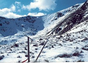 Between the two coves, Dollywaggon Pike sends out a fine rocky ridge, The Tongue. This arête
ascends by a series of rocky steps making straight for the summit. At the bottom of The Tongue is Spout Crag, standing above Grisedale Beck and forcing walkers to take a detour from the ridgeline.
North of Dollywaggon Pike the ridge narrows and then steps up over High Crag to the plateau top of Nethermost Pike. In the other direction the high ground curves south east around Cock Cove before a long slope falls to Grisedale Tarn
at around 1,770 ft. This sizeable tarn
has a depth of around 110 ft and holds brown trout, perch and eels. The outflow is to Ullswater to the north east, picking up all of the rainfall from the eastern face of Dollywaggon Pike. To the west of the tarn is the unnamed col between Dollywaggon Pike and Seat Sandal and immediately to the south is Grisedale Hause, the depression between Seat Sandal and Fairfield. Thus Seat Sandal stands topographically on the ridge between the two higher fells, but so out on a limb that many walkers proceed directly from Dollywaggon Pike to Fairfield.
with a larger one a few yards to the west. The view is extensive with the eastern foreground particularly fine
and the fell can also be reached from the Grasmere area via Grisedale Tarn. Ascents up the western slopes are unimpeded but uninteresting.
Fell
“Fell” is a word used to refer to mountains, or certain types of mountainous landscape, in Scandinavia, the Isle of Man, and parts of northern England.- Etymology :...
in the English
England
England is a country that is part of the United Kingdom. It shares land borders with Scotland to the north and Wales to the west; the Irish Sea is to the north west, the Celtic Sea to the south west, with the North Sea to the east and the English Channel to the south separating it from continental...
Lake District
Lake District
The Lake District, also commonly known as The Lakes or Lakeland, is a mountainous region in North West England. A popular holiday destination, it is famous not only for its lakes and its mountains but also for its associations with the early 19th century poetry and writings of William Wordsworth...
. It stands on the main spine of the Helvellyn range
Helvellyn range
Helvellyn range is the name given to a part of the Eastern Fells in the English Lake District, fell being the local word for hill. The name comes from Helvellyn, the highest point of the group....
in the Eastern Fells
Eastern Fells
The Eastern Fells are a group of hills in the English Lake District. Centred on Helvellyn they primarily comprise a north south ridge running between Ullswater and Lakeland's Central Valley.-Partition of the Lakeland Fells:...
, between Thirlmere
Thirlmere
Thirlmere is a reservoir in the Borough of Allerdale in Cumbria and the English Lake District. It runs roughly south to north, with a dam at the northern end, and is bordered on the eastern side by the A591 road and on the western side by a minor road....
and the Ullswater
Ullswater
Ullswater is the second largest lake in the English Lake District, being approximately nine miles long and 0.75 miles wide with a maximum depth of slightly more than ....
catchment.
Name
The spelling "Dollywaggon" is used on Ordnance SurveyOrdnance Survey
Ordnance Survey , an executive agency and non-ministerial government department of the Government of the United Kingdom, is the national mapping agency for Great Britain, producing maps of Great Britain , and one of the world's largest producers of maps.The name reflects its creation together with...
1:25,000 maps but "Dollywagon" on 1:50,000 maps. The Ordnance Survey gazeteer, nominally based on the 1:50,000 maps, lists only "Dollywaggon Pike". As of 2005, the "Dollywagon" spelling is slightly more common in online references. Alfred Wainwright
Alfred Wainwright
Alfred Wainwright MBE was a British fellwalker, guidebook author and illustrator. His seven-volume Pictorial Guide to the Lakeland Fells, published between 1955 and 1966 and consisting entirely of reproductions of his manuscript, has become the standard reference work to 214 of the fells of the...
used "Dollywaggon Pike" in his Pictorial Guide, a position supported by other writers.
Topography
Nethermost Pike
Nethermost Pike is a fell in Cumbria, England, and a part of the Lake District. At it is the second highest Wainwright in the Helvellyn range, the tallest of which is Helvellyn itself. It is located close to the southern end of the ridge, with Helvellyn to the north, and High Crag and Dollywaggon...
immediately to the north. There is a subsidiary top between Nethermost and Dollywaggon Pikes named High Crag (2,900 ft). Due to the very limited depression between the two, most guidebooks follow Wainwright in counting High Crag as a part of Nethermost Pike. To the south of Dollywaggon Pike is the complex depression containing Grisedale Tarn, with Seat Sandal
Seat Sandal
Seat Sandal is a fell in the English Lake District, it is situated four kilometers north of the village of Grasmere from where it is very well seen...
and Fairfield
Fairfield (Lake District)
Fairfield is a fell in the English Lake District. It is the highest of a group of hills in the Eastern Fells, standing to the south of the Helvellyn range.-Topography:...
rising beyond.
In common with much of the Helvellyn range there is a marked contrast between the western and eastern slopes of Dollywaggon Pike. In Wainwright's words "To the west, uninteresting grass slopes descend to Dunmail Raise
Dunmail Raise
Dunmail Raise is a hill in the English Lake District, the highest point of a pass on the Keswick-Kendal road, the A591, to the south of Thirlmere reservoir on the way to Grasmere, in the Lake District National Park...
almost unrelieved by rock and scarred only by the wide stony track gouged across the breast of the fell by the boots of generations of pilgrims to Helvellyn
Helvellyn
Helvellyn is a mountain in the English Lake District, the apex of the Eastern Fells. At above sea level, it is the third highest peak in both the Lake District and England...
. But the eastern side is a desolation of crag and boulder and scree."
Grasmere (lake)
Grasmere is one of the smaller lakes of the English Lake District, in the county of Cumbria. It gives its name to the village of Grasmere, famously associated with the poet William Wordsworth, which lies immediately to the north of the lake....
and Windermere
Windermere (lake)
Windermere is the largest natural lake in England. It is a ribbon lake formed in a glacial trough after the retreat of ice at the start of the current interglacial. It has been one of the country’s most popular places for holidays and summer homes since the arrival of the Kendal and Windermere...
to reach Morecambe Bay
Morecambe Bay
Morecambe Bay is a large bay in northwest England, nearly due east of the Isle of Man and just to the south of the Lake District National Park. It is the largest expanse of intertidal mudflats and sand in the United Kingdom, covering a total area of 310 km².-Natural features:The rivers Leven,...
, Birkside Gill going through Thirlmere
Thirlmere
Thirlmere is a reservoir in the Borough of Allerdale in Cumbria and the English Lake District. It runs roughly south to north, with a dam at the northern end, and is bordered on the eastern side by the A591 road and on the western side by a minor road....
and Derwent Water
Derwent Water
Derwentwater is one of the principal bodies of water in the Lake District National Park in north west England. It lies wholly within the Borough of Allerdale, in the county of Cumbria....
to reach the Irish Sea
Irish Sea
The Irish Sea separates the islands of Ireland and Great Britain. It is connected to the Celtic Sea in the south by St George's Channel, and to the Atlantic Ocean in the north by the North Channel. Anglesey is the largest island within the Irish Sea, followed by the Isle of Man...
at Workington
Workington
Workington is a town, civil parish and port on the west coast of Cumbria, England, at the mouth of the River Derwent. Lying within the Borough of Allerdale, Workington is southwest of Carlisle, west of Cockermouth, and southwest of Maryport...
and Grisedale Beck draining into Ullswater
Ullswater
Ullswater is the second largest lake in the English Lake District, being approximately nine miles long and 0.75 miles wide with a maximum depth of slightly more than ....
and then to the sea at the Solway Firth
Solway Firth
The Solway Firth is a firth that forms part of the border between England and Scotland, between Cumbria and Dumfries and Galloway. It stretches from St Bees Head, just south of Whitehaven in Cumbria, to the Mull of Galloway, on the western end of Dumfries and Galloway. The Isle of Man is also very...
. This is still the case today when there is enough water in Raise Beck for it to flow both north and south, but normally Seat Sandal now has this distinction.
Birkside Gill contains the remains of a number of levels driven for copper
Copper
Copper is a chemical element with the symbol Cu and atomic number 29. It is a ductile metal with very high thermal and electrical conductivity. Pure copper is soft and malleable; an exposed surface has a reddish-orange tarnish...
between 1840 and 1866.
On the east, the first impression is all of rock. The long strath of Grisedale runs north eastward to Ullswater, cutting off a series of hanging valleys which fall from the Helvellyn range. To the north east of Dollywaggon Pike, below the summit of High Crag, is Ruthwaite Cove, a corrie
Cirque
Cirque may refer to:* Cirque, a geological formation* Makhtesh, an erosional landform found in the Negev desert of Israel and Sinai of Egypt*Cirque , an album by Biosphere* Cirque Corporation, a company that makes touchpads...
surrounded on three sides by crag. Ruthwaite Cove is now the site of Ruthwaite Lodge, a climbing hut. It was formerly the setting for more industrious activity, with the remains of several levels and some shallow open mineworking being visible near the Lodge. These excavations were made for lead
Lead
Lead is a main-group element in the carbon group with the symbol Pb and atomic number 82. Lead is a soft, malleable poor metal. It is also counted as one of the heavy metals. Metallic lead has a bluish-white color after being freshly cut, but it soon tarnishes to a dull grayish color when exposed...
bearing galena
Galena
Galena is the natural mineral form of lead sulfide. It is the most important lead ore mineral.Galena is one of the most abundant and widely distributed sulfide minerals. It crystallizes in the cubic crystal system often showing octahedral forms...
, and are believed to have been worked in the sixteenth century. Further leases were taken out in 1784 and 1862, the last known operation being in 1880. To the east of Dollywaggon Pike is a second corrie, Cock Cove with Falcon Crag and the deeply gullied Tarn Crag providing the impressive headwall.
Arete
Areté is the term meaning "virtue" or "excellence", from Greek ἈρετήArete may also be used:*as a given name of persons or things:**Queen Arete , a character in Homer's Odyssey.***197 Arete, an asteroid....
ascends by a series of rocky steps making straight for the summit. At the bottom of The Tongue is Spout Crag, standing above Grisedale Beck and forcing walkers to take a detour from the ridgeline.
North of Dollywaggon Pike the ridge narrows and then steps up over High Crag to the plateau top of Nethermost Pike. In the other direction the high ground curves south east around Cock Cove before a long slope falls to Grisedale Tarn
Grisedale Tarn
Grisedale Tarn is a tarn in the Lake District between Fairfield and Dollywagon Pike.It is the legendary resting place of the crown of the kingdom of Cumbria, after the crown was conveyed there in 945 by soldiers of the last king, Dunmail, after he was slain in battle with the combined forces of the...
at around 1,770 ft. This sizeable tarn
Tarn (lake)
A tarn is a mountain lake or pool, formed in a cirque excavated by a glacier. A moraine may form a natural dam below a tarn. A corrie may be called a cirque.The word is derived from the Old Norse word tjörn meaning pond...
has a depth of around 110 ft and holds brown trout, perch and eels. The outflow is to Ullswater to the north east, picking up all of the rainfall from the eastern face of Dollywaggon Pike. To the west of the tarn is the unnamed col between Dollywaggon Pike and Seat Sandal and immediately to the south is Grisedale Hause, the depression between Seat Sandal and Fairfield. Thus Seat Sandal stands topographically on the ridge between the two higher fells, but so out on a limb that many walkers proceed directly from Dollywaggon Pike to Fairfield.
Geology
Geologically the summit of the fell forms part of the Deepdale Formation, (principally volcaniclastic sandstone) underlain by the dacitic lapilli-tuff of the Helvellyn Formation.Summit and View
The summit is a small grassy rise directly at the head of The Tongue. It carries a small cairnCairn
Cairn is a term used mainly in the English-speaking world for a man-made pile of stones. It comes from the or . Cairns are found all over the world in uplands, on moorland, on mountaintops, near waterways and on sea cliffs, and also in barren desert and tundra areas...
with a larger one a few yards to the west. The view is extensive with the eastern foreground particularly fine
Ascents
The Tongue provides a fine route of ascent, though a long one, from PatterdalePatterdale
Patterdale is a small village and civil parish in the eastern part of the English Lake District in the Eden District of Cumbria, and the long valley in which they are found, also called the Ullswater Valley....
and the fell can also be reached from the Grasmere area via Grisedale Tarn. Ascents up the western slopes are unimpeded but uninteresting.