

Neighborhoods of Portland, Maine
Encyclopedia
Arts District
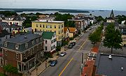
Portland's Arts District is based around Congress Street
Congress Street (Portland, Maine)
Congress Street is the main street in Portland, Maine. Congress stretches from Portland's southwestern border with South Portland through a number of neighborhoods before ending overlooking the Eastern Promenade on Munjoy Hill...
in downtown Portland. The District includes the Portland Museum of Art
Portland Museum of Art
The Portland Museum of Art is an art museum in Portland, Maine. Founded as the Portland Society of Art in 1882, it is located in the downtown area known as The Arts District, and is the largest and oldest public art institution in the U.S...
, the Children's Museum of Maine
Children's Museum of Maine
Children's Museum & Theatre of Maine is located in the Arts District of downtown Portland, Maine and features a wide variety of interactive exhibits and activities for children and families. Children's Museum & Theatre of Maine exists to inspire discovery and imagination through exploration and play...
, the Maine College of Art
Maine College of Art
The Maine College of Art is a fully accredited, degree-granting art college in the city of Portland, Maine. It should not be confused with the Art Institute of Portland which is located in Portland, Oregon. Founded in 1882, the Maine College of Art is the oldest arts educational institution in Maine...
(MECA) and the State Theatre
State Theatre (Portland, Maine)
The State Theatre is a historic theater located at 609 Congress Street in downtown Portland, Maine. It features a combination of Moorish and Art Deco architecture. It reopened as a performing arts venue in 2010.-History of the State Theatre:...
. It is a mixed use neighborhood with both apartments and commercial establishments.
Back Cove
Back Cove is a neighborhood off of Portland's peninsula and downtown areas. With views of the Portland skyline across Back CoveBack Cove, Portland, Maine
Back Cove is an estuary basin on the northern side of the City of Portland, Maine's downtown district. It is nearly circular and about one mile in diameter. A popular loop trail runs around the circumference of the cove. Being tidal, Back Cove dries out to mud flats at low tide and is not...
, it borders the neighborhoods of Deering Center
Deering Center, Maine
Deering Center is a neighborhood in the residential area of Portland, Maine, United States.Deering Center runs from Brighton Avenue to Forest Avenue to Catherine McAuley High School near Wayside Street on Ludlow Street.-History:...
, North Deering, East Deering, Rosemont, and Oakdale.
Neighborhood boundaries are: Washington Avenue (North), Baxter Boulevard (East), Forest Avenue (South), and Canco Road (West).
Within the boundaries of the Back Cove neighborhood are Woodford's Corner, Ocean Avenue, Payson Park, Cheverus High School
Cheverus High School
Cheverus High School is a private, Jesuit, college-preparatory school in Portland, Maine. It is located in the Roman Catholic Diocese of Portland. Cheverus High School was founded in 1917 as a Diocesan school and was named after French Roman Catholic Cardinal Jean-Louis Lefebvre de Cheverus...
(private Jesuit school), and Ocean Avenue School (Portland Public Schools).
External links
Downtown
East Deering
East Deering is the easternmost neighborhood of the city of Portland, Maine
Portland, Maine
Portland is the largest city in Maine and is the county seat of Cumberland County. The 2010 city population was 66,194, growing 3 percent since the census of 2000...
. The suburban neighborhood is situated between the Munjoy Hill
Munjoy Hill
Munjoy Hill is an historically Irish-American neighborhood and prominent geographical feature of Portland, Maine. It is located east of downtown, and south of East Deering, the neighborhood it is connected to by Tukey's Bridge.-Geography:...
and North Deering neighborhoods of the city, as well as the town of Falmouth
Falmouth, Maine
Falmouth is a town in Cumberland County, Maine, United States. The population was 11,185 at the 2010 census. It is part of the Portland–South Portland–Biddeford, Maine metropolitan statistical area....
. East Deering is an economically diverse place, featuring both public housing
Public housing
Public housing is a form of housing tenure in which the property is owned by a government authority, which may be central or local. Social housing is an umbrella term referring to rental housing which may be owned and managed by the state, by non-profit organizations, or by a combination of the...
and more expensive single family homes. Much of the neighborhood has views of Casco Bay
Casco Bay
Casco Bay is an inlet of the Gulf of Maine on the southern coast of Maine, New England, United States. Its easternmost approach is Cape Small and its westernmost approach is Two Lights in Cape Elizabeth...
and nearby Mackworth Island
Mackworth Island
Mackworth Island is an approximately island on the border line of Falmouth, Maine and Portland, Maine. In 1631, Sir Ferdinando Gorges gave the island to Arthur Mackworth, his deputy in Casco Bay, and the island has retained his name. There is a causeway connecting the island to the mainland in...
East Deering was bisected by 295 in the 1960s. Major landmarks in this neighborhood include the Burnham and Morrill Co. (B&M) Baked Bean manufacturing plant, Martin's Point, Presumpscot School, Payson Park, and Lunts Corner.
Payson Park, Presumpscot Elementary School and Martin's Point are also in the neighborhood.
The major throughways in East Deering are Washington Avenue and Veranda Street.
East Bayside
East Bayside is a neighborhood in Portland
Portland, Maine
Portland is the largest city in Maine and is the county seat of Cumberland County. The 2010 city population was 66,194, growing 3 percent since the census of 2000...
, Maine
Maine
Maine is a state in the New England region of the northeastern United States, bordered by the Atlantic Ocean to the east and south, New Hampshire to the west, and the Canadian provinces of Quebec to the northwest and New Brunswick to the northeast. Maine is both the northernmost and easternmost...
. It is bordered by Franklin Street
Franklin Street (Portland)
Franklin Street is a four-lane street in Portland, Maine. It began as Essex Street in the 18th century, but changed to Franklin Street by 1823. It is a major corridor for traffic from Interstate 295 to Portland's downtown, and to other neighborhoods located on the Portland peninsula.- History...
on the west, Washington Avenue on the east, to the north by Marginal Way, and the south by Congress Street. It was first developed a street network
Street network
A street network is a system of interconnecting lines and points that represent a system of streets for a given area. A street network provides the foundation for network analysis; for example, finding the best route or creating service areas. They greatly affect in-town movement and traffic....
in the early 19th century. By the 1820’s the area was Portland’s second seaport via the Back Cove
Back Cove
- Canada :* Back Cove, Burgeo, Newfoundland and Labrador* Back Cove, Fogo, Newfoundland and Labrador* Back Cove, hamlet, Newfoundland and Labrador* Back Cove, St. Barbe, Newfoundland and Labrador...
’s ship channel. In 1840 the Union Railroad
Union Railroad
The following railroads have been named Union Railroad or Union Railway, usually because they connected or merged several other railroads. See joint railway for the concept of a railroad owned by more than one company.Freight carriers...
ran along the then shoreline of Back Cove, following approximately where Oxford Street is today. Much of the debris from the great Portland fire of 1866 was deposited into Back Cove, significantly increasing the size of East Bayside. Maps produced around 1900 show an extension of the shoreline out to Marginal Way. The shoreline would not change again until the construction of the Interstate in 1974.
East End
Munjoy Hill
Munjoy Hill is an historically Irish-American neighborhood and prominent geographical feature of Portland, Maine. It is located east of downtown, and south of East Deering, the neighborhood it is connected to by Tukey's Bridge.-Geography:...
and the Eastern Promenade
Eastern Promenade
The Eastern Promenade is an historic promenade, public park and recreation area in Portland, Maine. Construction of the Promenade began in 1836 and continued periodically until 1934. The park was designed by the Olmstead Brothers design firm and experienced its greatest expansion from the 1880s...
. The East End Community School, located on North Street, serves the area. The East End Beach
East End Beach
The East End Beach is a small beach on the North Atlantic Ocean in Portland, Maine. It is located in the East End/Eastern Promenade neighborhood on Portland's peninsula.-External links:* Geographic Names Information System...
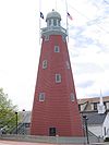
is also located there. Notable buildings include the Portland Observatory
Portland Observatory
The Portland Observatory, built in 1807 at Portland, Maine, is the last surviving maritime signal tower in the United States. Using both a telescope and signal flags, two-way communication between ship and shore was possible several hours before an incoming vessel reached the...
at the top of Munjoy Hill.
Libbytown
Libbytown is a neighborhood in southern and western Portland, wedged between the Stroudwater, Rosemont, Oakdale, and Parkside neighborhoods, and separated from the city of South PortlandSouth Portland, Maine
South Portland is a city in Cumberland County, Maine, United States, and is the fourth-largest city in the state. Founded in 1895, as of the 2010 census, the city population was 25,002. Known for its working waterfront, South Portland is situated on Portland Harbor and overlooks the skyline of...
by the Fore River. Maine's busiest public transit hub, the Portland Transportation Center, is in Libbytown.
It was originally settled by Irish Catholic immigrants. Described as cohesive, it began to decline following the 1961 destruction of Union Station on St. John Street. It is named after the Libby family, who immigrated from Ireland in the mid-ninteenth century and set up three business between Park Avenue and outer Congress Street
Congress Street (Portland, Maine)
Congress Street is the main street in Portland, Maine. Congress stretches from Portland's southwestern border with South Portland through a number of neighborhoods before ending overlooking the Eastern Promenade on Munjoy Hill...
. It extends to the intersection of Stevens Avenue and Congress Street. Tony's Donuts, a donut shop, was established in the neighborhood in 1965.
North Deering
North Deering is the northernmost neighborhood of the city of Portland, MainePortland, Maine
Portland is the largest city in Maine and is the county seat of Cumberland County. The 2010 city population was 66,194, growing 3 percent since the census of 2000...
. It is situated next to the Riverton and East Deering neighborhoods of the city, as well as the town of Falmouth
Falmouth, Maine
Falmouth is a town in Cumberland County, Maine, United States. The population was 11,185 at the 2010 census. It is part of the Portland–South Portland–Biddeford, Maine metropolitan statistical area....
. It is home to some of the oldest surviving houses in the city, because the neighborhood was spared all of the four fires that plagued much of the rest of the city in the past. In North Deering's early history it had an agriculture
Agriculture
Agriculture is the cultivation of animals, plants, fungi and other life forms for food, fiber, and other products used to sustain life. Agriculture was the key implement in the rise of sedentary human civilization, whereby farming of domesticated species created food surpluses that nurtured the...
and lumber
Lumber
Lumber or timber is wood in any of its stages from felling through readiness for use as structural material for construction, or wood pulp for paper production....
based economy, but with the spread of the automobile
Automobile
An automobile, autocar, motor car or car is a wheeled motor vehicle used for transporting passengers, which also carries its own engine or motor...
, North Deering became more economically connected to the rest of the city. Today it has become a suburban neighborhood with some retail
Retail
Retail consists of the sale of physical goods or merchandise from a fixed location, such as a department store, boutique or kiosk, or by mail, in small or individual lots for direct consumption by the purchaser. Retailing may include subordinated services, such as delivery. Purchasers may be...
activity. It is home to WGME, Portland's local CBS
CBS
CBS Broadcasting Inc. is a major US commercial broadcasting television network, which started as a radio network. The name is derived from the initials of the network's former name, Columbia Broadcasting System. The network is sometimes referred to as the "Eye Network" in reference to the shape of...
affiliate.
It is served by Harrison Lyseth Elementary School, and Lyman Moore Middle School (which also serves the East Deering and Munjoy Hill
Munjoy Hill
Munjoy Hill is an historically Irish-American neighborhood and prominent geographical feature of Portland, Maine. It is located east of downtown, and south of East Deering, the neighborhood it is connected to by Tukey's Bridge.-Geography:...
neighborhoods). North Deering high school aged students choose between attending Portland High School
Portland High School, Portland, Maine
Portland High School is a public high school in Portland, Maine which educates grades 9–12. The school is part of the Portland Public Schools district....
, Deering High School
Deering High School
Deering High School is a public high school in Portland, Maine which educates grades 9–12. The school is part of the Portland Public Schools district. It is named after the Deering Center neighborhood it serves...
, or Casco Bay High School
Casco Bay High School
Casco Bay High School is a public Expeditionary Learning school in Portland, Maine, USA. Since the 2005–06 school year, the school has been housed on the site of the Portland Arts and Technology High School on Allen Avenue, in the city's North Deering neighborhood...
, all three of which serve the entire city.
Parkside
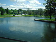
Deering Oaks
Deering Oaks is a public park in Portland, Maine, which has a baseball diamond, tennis courts, a playground, and a pond. It is located west of downtown Portland and is bordered by Deering Avenue on the west, Forest Avenue on the east, Park Avenue to the south and Interstate 295 to the north. State...
, an historic park officially established in 1879. Called "Maine’s most notorious neighborhood" by The Bollard
The Bollard
The Bollard is a monthly local magazine in Portland, Maine. Covering local news and arts, the first issue was published in 2005. From 2005 to June 2008, it printed quarterly and thereafter switched to monthly publications. It is a free publication available in public places across southern Maine...
in 2009, Parkside is bordered to the north by Deering Oaks. Hadlock Field
Hadlock Field
Hadlock Field is a Minor League baseball stadium in Portland, Maine. It is primarily home to the Portland Sea Dogs of the Eastern League. It is also the home of the Portland Bulldogs and Deering Rams baseball teams. The stadium is named for Edson J...
, home of the Portland Seadogs, roughly forms the southern border of the neighborhood. Herb Adams
Herbert Adams (politician)
Herbert Adams is a Maine politician and historian. A Democrat, Adams was a member of the Portland School Committee from 1997-2004. He represented the Portland neighborhoods of East Bayside and Parkside]] in the Maine House of Representatives. He is also a noted historian of local history, having...
resides in and represented the district in the Maine House of Representatives
Maine House of Representatives
The Maine House of Representatives is the lower house of the Maine Legislature. The House consists of 151 members representing an equal amount of districts across the state. Each voting member of the House represents around 8,450 citizens of the state...
. The neighborhood began following the 1866 Great Fire of Portland, Maine
1866 Great Fire of Portland, Maine
The Great Fire of Portland, Maine occurred on July 4, 1866 — the first Independence Day after the end of the American Civil War. Five years before the Great Chicago Fire, this was the greatest fire yet seen in an American city. It started in a boat house on Commercial Street, likely caused by...
when most of Portland's waterfront and downtown were burned. Residents moved south across the peninsula and laid out Sherman Ave. and Grant Ave. (now streets), named after Civil War generals William Tecumseh Sherman
William Tecumseh Sherman
William Tecumseh Sherman was an American soldier, businessman, educator and author. He served as a General in the Union Army during the American Civil War , for which he received recognition for his outstanding command of military strategy as well as criticism for the harshness of the "scorched...
and future President Ulysses S. Grant
Ulysses S. Grant
Ulysses S. Grant was the 18th President of the United States as well as military commander during the Civil War and post-war Reconstruction periods. Under Grant's command, the Union Army defeated the Confederate military and ended the Confederate States of America...
. The homes in the neighborhood are primarily Triple decker
Triple decker
A triple-decker is a three-story apartment building, typically of light-framed, wood construction, where each floor usually consists of a single apartment; although two apartments per floor is not uncommon....
buildings and soon after its founding became home to much of Portland's Italian
Italian diaspora
The term Italian diaspora refers to the large-scale migration of Italians away from Italy in the period roughly beginning with the unification of Italy in 1861 and ending with the Italian economic miracle in the 1960s...
and Irish
Irish diaspora
thumb|Night Train with Reaper by London Irish artist [[Brian Whelan]] from the book Myth of Return, 2007The Irish diaspora consists of Irish emigrants and their descendants in countries such as the United Kingdom, the United States, Canada, Australia, Argentina, New Zealand, Mexico, South Africa,...
immigrant populations. The neighborhood was previously known for rampant drug use and prostitution.
Riverton
Riverton neighborhood is located in northwestern Portland. The Riverton Trolley Park, established in 1896, was located in the neighborhood. The park closed in 1929. At the time, it was a premier leisure destination. A trolley brought people from Monument SquareMonument Square (Portland, Maine)
Monument Square is a town square in Portland, Maine. The Time and Temperature Building and the Portland Public Library are on Congress Street across from the square, while One Monument Square and One City Center are located on the square....
to the area. A branch of the Portland Public Library is located there as well. Riverton Elementary School serves as the neighborhood school. The University of New England merged with Westbrook College
Westbrook College
Westbrook College was a liberal arts college in Portland, Maine founded 1831 as Westbrook Seminary in Westbrook, Maine. It closed in 1996 and merged with the University of New England, which uses its old campus.-History:...
in 1996, with Westbrook College's campus in Riverton becoming UNE's Portland Campus. It is home of the Westbrook College Historic District
Westbrook College Historic District
Westbrook College Historic District is an historic district in the Riverton neighborhood of Portland, Maine. It is centered on the campus of the former Westbrook College, which merged with the University of New England in 1996. The district was added to the National Register of Historic Places in...
.
Rosemont
Rosemont is a neighborhood in Portland located close to Deering Center and other off-peninsula neighborhoods. In 2008, it was home to a number of former city councilors.Stroudwater
Stroudwater is located in the southwest corner of Portland, bordered by the Nasons Corner and Libbytown neighborhoods to the north and east, the city of WestbrookWestbrook, Maine
Westbrook is a city in Cumberland County, Maine, United States and a suburb of Portland. The population was 17,494 at the 2010 census. It is part of the Portland–South Portland–Biddeford, Maine metropolitan statistical area.-History:...
to the west, and the city of South Portland
South Portland, Maine
South Portland is a city in Cumberland County, Maine, United States, and is the fourth-largest city in the state. Founded in 1895, as of the 2010 census, the city population was 25,002. Known for its working waterfront, South Portland is situated on Portland Harbor and overlooks the skyline of...
to the south. Maine's busiest airport, the Portland International Jetport
Portland International Jetport
Portland International Jetport is a public airport located two miles west of the central business district of Portland, in Cumberland County, Maine, United States. It is owned by the city of Portland...
, originally known as Stroudwater Field, is located here. Stroudwater is home to a number of historic structures, including the oldest standing building in Portland, the Tate House and Museum, which was built in 1755. The Stroudwater Historic District
Stroudwater Historic District
Stroudwater Historic District is a historic district in the Stroudwater neighborhood of Portland, Maine. The district was added to the National Register of Historic Places in 1973. The Tate House, a historic house built in 1755, is located in the district....
is also located here. It is home to the mouth of the Stroudwater River
Stroudwater River
The Stroudwater River is a river located mostly in Cumberland County, Maine. The river begins as a small stream at Duck Pond in Buxton and grows as it flows through Buxton, Gorham, Westbrook, and finally Portland before emptying into the Fore River near Portland's Stroudwater neighborhood...
.
History
Stroudwater was founded as a hamletHamlet
The Tragical History of Hamlet, Prince of Denmark, or more simply Hamlet, is a tragedy by William Shakespeare, believed to have been written between 1599 and 1601...
which, with power generated by the Stroudwater River and Fore Rivers, was an important producer of masts for the Royal Navy
Royal Navy
The Royal Navy is the naval warfare service branch of the British Armed Forces. Founded in the 16th century, it is the oldest service branch and is known as the Senior Service...
. In the 2000s, Stroudwater was considered a quiet suburb of Downtown Portland, though it is still officially within the city boundaries.
West End
The West End is a neighborhood in Portland, Maine
Portland, Maine
Portland is the largest city in Maine and is the county seat of Cumberland County. The 2010 city population was 66,194, growing 3 percent since the census of 2000...
. Located on the western side of Portland's peninsula, it includes a number of historical and well-preserved architecture.
Noted for its architecture, the West End is home to a number of historical homes and the Western Promenade Historic District
Western Promenade Historic District
The Western Promenade Historic District is an historic district listed on the National Register of Historic Places. It is bounded by the Western Promenade and Bramhall, Brackett, Emery, and Danforth Streets. It includes a number of homes dating from the late nineteenth and early twentieth...
. In 2010, it was called "one of the best preserved Victorian neighborhoods in the country". The Western Promenade
Western Promenade
The Western Promenade is an historic promenade, public park and recreation area in Portland, Maine's West End neighborhood. It is listed on the National Register of Historic Places and includes a number of historic properties, including the Adam P. Leighton House. Maine Medical Center is also...
features prominently in the neighborhood. Other historical buildings include The Gothic House
The Gothic House
The Gothic House also known as the John J. Brown House is an historic house in Portland, Maine. Located in the West End, it was built in 1845 and listed on the National Register of Historic Places in 1974....
, Harrison B. Brown House
Harrison B. Brown House
Harrison Bird Brown House is an historic house in Portland, Maine. Located in the West End, it was built in 1861 and listed on the National Register of Historic Places in 1980....
, A.B. Butler House
A.B. Butler House
A.B. Butler House is an historic house in Portland, Maine. Located in the West End, it was listed on the National Register of Historic Places in 1974....
, Joseph Holt Ingraham House
Joseph Holt Ingraham House
Joseph Holt Ingraham House or Churchill House is an historic house in Portland, Maine. Located in the Portland's West End, it was listed on the National Register of Historic Places in 1973....
, Morrill Mansion, William Minott House
William Minott House
William Minott House is an historic house in Portland, Maine. Located in the Portland's West End, it was listed on the National Register of Historic Places in 1979.-References:...
and Waynflete School
Waynflete School
Waynflete School is a private, coeducational, college preparatory day school for early childhood education to twelfth grade, in Portland, Maine. Established in 1898, it is one of three independent private schools in the greater Portland area....
. The Western Cemetery
Western Cemetery (Portland, Maine)
The Western Cemetery is an urban cemetery in Portland, Maine. At one time Portland's home for the "poor and indigent", the cemetery is named after for its location in Portland's West End neighborhood and proximity to the Western Promenade. Founded in the 18th century, the land was acquired by the...
, Portland's primary cemetery from 1829-1852, is located in the neighborhood as well. Maine Medical Center
Maine Medical Center
Maine Medical Center is a 637 licensed-bed teaching hospital located in Portland, Maine, United States with a staff of over 6,000 people. Founded in 1874, it is the largest hospital in northern New England with 27,000 inpatients, more than 500,000 outpatient visits and over 16,000 surgeries...
, Maine's largest hospital and Portland's largest employer, is also located in the West End.