

Neighborhoods of Minneapolis
Encyclopedia
City
A city is a relatively large and permanent settlement. Although there is no agreement on how a city is distinguished from a town within general English language meanings, many cities have a particular administrative, legal, or historical status based on local law.For example, in the U.S...
of Minneapolis, Minnesota
Minneapolis, Minnesota
Minneapolis , nicknamed "City of Lakes" and the "Mill City," is the county seat of Hennepin County, the largest city in the U.S. state of Minnesota, and the 48th largest in the United States...
is officially defined by the Minneapolis City Council
Minneapolis City Council
The Minneapolis City Council is the governing body of the City of Minneapolis. The City Council is composed of 13 single member districts, called wards. Barbara Johnson is president of the council. The council is dominated by members of the DFL Party with 12 members. The Green Party has one member...
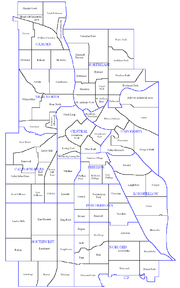
as divided into eleven communities, each containing multiple official neighborhoods. Informally, there are city areas with colloquial labels. Residents may also group themselves by city street suffixes South, North, Southeast, and Northeast.
The Council has authority to define neighborhood boundaries by the State Legislature, but these are separate from Council Ward boundaries, which are adjusted after each decennial census
United States Census
The United States Census is a decennial census mandated by the United States Constitution. The population is enumerated every 10 years and the results are used to allocate Congressional seats , electoral votes, and government program funding. The United States Census Bureau The United States Census...
.
Common conceptions of Minneapolis neighborhoods do not always align with official city map
City map
A city map is a large-scale thematic map of a city created to enable the fastest possible orientation in an urban space. The graphic representation of objects on a city map is therefore usually greatly simplified, and reduced to generally understood symbology.Depending upon its target group or...
s, especially since much of the Minneapolis-St. Paul metropolitan area
Metropolitan area
The term metropolitan area refers to a region consisting of a densely populated urban core and its less-populated surrounding territories, sharing industry, infrastructure, and housing. A metropolitan area usually encompasses multiple jurisdictions and municipalities: neighborhoods, townships,...
's population now lives outside of the two major cities. Generalized names such as "North Minneapolis" are actually a combination of the Near North
Near North, Minneapolis
Near North is a community on the north side of Minneapolis. Contained within it are six smaller neighborhoods. Near North is the primary area represented in the North Minneapolis Encyclopedia, InsideNorthside....
and Camden
Camden, Minneapolis
Camden is a community in Minneapolis, covering the upper half of the north side. Its boundaries are 53rd Avenue North to the north, the Mississippi River to the east, Lowry Avenue North to the south, and Xerxes Avenue North to the west. The community is composed of seven smaller neighborhoods...
communities with each of these communities made up of several neighborhoods.
General areas
The local communityLocal community
A local community is a group of interacting people sharing an environment. In human communities, intent, belief, resources, preferences, needs, risks, and a number of other conditions may be present and common, affecting the identity of the participants and their degree of cohesiveness.- Overview...
defines several general areas based on the directional suffixes added to streets in the city. These city areas do not necessarily correlate with official community or neighborhood definitions.
Downtown Minneapolis refers to the street grid area aligned on a diagonal with the Mississippi River bend as opposed to the true north grid orientation. South of this grid begins South Minneapolis. Southwest Minneapolis is not as clearly defined within South Minneapolis. The core is considered the official community of Southwest
Southwest, Minneapolis
The Southwest community consists of the following neighborhoods: Linden Hills, East Harriet, Kingfield, Fulton, Lynnhurst, Tangletown, Armatage, Kenny, and Windom. This portion of Minneapolis contains many parks and trails along Lake Harriet and Minnehaha Creek....
is bounded on the north by the line of 36th St W, extending west from where it ends at Lake Calhoun, and on the east by I-35W
Interstate 35W (Minnesota)
Interstate 35W , is an Interstate Highway in the U.S. state of Minnesota, passing through downtown Minneapolis. It is one of two through routes for Interstate 35 through the Twin Cities of Minneapolis and Saint Paul, the other being Interstate 35E through downtown Saint Paul...
.
The part of Minneapolis on the east bank of the Mississippi River
Mississippi River
The Mississippi River is the largest river system in North America. Flowing entirely in the United States, this river rises in western Minnesota and meanders slowly southwards for to the Mississippi River Delta at the Gulf of Mexico. With its many tributaries, the Mississippi's watershed drains...
is divided into Northeast and Southeast street suffixes by East Hennepin Avenue. These suffixes approximately align with the communities of Northeast
Northeast, Minneapolis
Northeast is a defined community in the U.S. city of Minneapolis, Minnesota, composed of 13 smaller neighborhoods whose street addresses end in "NE". Unofficially it also includes the neighborhoods of the University community which have "NE" addresses, and the entirety of the Old Saint Anthony...
and University
University, Minneapolis
University is a community in Minneapolis. It is composed of six smaller neighborhoods. It also contains the University of Minnesota campus and the Mid-City Industrial Area, which isn't assigned to an official neighborhood....
respectively. The Old St. Anthony business district along Main Street Southeast tends to orientate toward Northeast.
The University of Minnesota
University of Minnesota
The University of Minnesota, Twin Cities is a public research university located in Minneapolis and St. Paul, Minnesota, United States. It is the oldest and largest part of the University of Minnesota system and has the fourth-largest main campus student body in the United States, with 52,557...
-oriented University community and the traditionally working-class Northeast community have quite distinct identities.
Official communities and neighborhoods
Minneapolis consists of 11 communities, each of which are subdivided into anywhere between 4 to 13 neighborhoods. The official neighborhoods have a variety of origins; some were formed out of the attendance areas for elementary schools, while others are the areas of coverage of neighborhood associations formed by activists between 1901 and the 1980s. The division of the city into official neighborhoods and communities occurred as part of the Neighborhood Revitalization Program (NRP) in the early 1990s. They remain associated with this community-based funding program, and are also used for statistical purposes. For purposes of the NRP, some of the 81 official neighborhoods have combined forces, leading to a total of 67 NRP Neighborhood action plans.Neighborhoods historically defined themselves around schools and commercial hubs, and many trace neighborhood identity back into community organizations formed in the early part of the 20th Century. The oldest, the Prospect Park
Prospect Park, Minneapolis
Prospect Park is an historic neighborhood within the University community of the U.S. city of Minneapolis, Minnesota. The area is bounded by the Mississippi River to the south, the City of Saint Paul, Minnesota to the east, the Burlington Northern railroad yard to the north, and the Stadium...
East River Road Association formed in 1901 to oppose city plans to level Tower Hill. In other neighborhoods, the current official neighborhood association was formed in the 1970s and 1980s; in Linden Hills
Linden Hills, Minneapolis
Linden Hills is a neighborhood in the Southwest community of Minneapolis. It is bordered to the north by Lake Calhoun, to the east by Lake Harriet, to the south by West 47th Street, and to the west by France Avenue.According to the 2000 U.S...
, the organization was formed in 1972 in response to proposed changes in the park, although there were several social and commercial organizations in the neighborhood dating back to the neighborhood's development at the turn of the 20th Century.
Calhoun-IslesCalhoun Isles, MinneapolisCalhoun-Isles is one of the official communities of Minneapolis, Minnesota. It contains the Uptown business district and the name "Uptown" is frequently used to refer to the entire community...
|
|
|
|
|
|
|
|
|
West Calhoun, Minneapolis West Calhoun is a neighborhood in Minneapolis, Minnesota. It is the southwesternmost neighborhood of the Calhoun Isles community, an affluent region in the western part of the city. West Calhoun is bordered on the east by East Calhoun, or "ECCO", the north by Cedar-Isles-Dean, the south by Linden... |
CamdenCamden, MinneapolisCamden is a community in Minneapolis, covering the upper half of the north side. Its boundaries are 53rd Avenue North to the north, the Mississippi River to the east, Lowry Avenue North to the south, and Xerxes Avenue North to the west. The community is composed of seven smaller neighborhoods...
|
|
|
|
|
Victory, Minneapolis The Victory neighborhood is located within the Camden community of Minneapolis. It is bordered by the Humboldt Industrial Area on the north, Penn Avenue on the east, Dowling Avenue on the south, and the town of Robbinsdale on the west... |
Webber-Camden, Minneapolis The Webber-Camden neighborhood is located in the Camden community of Minneapolis, Minnesota. Its boundaries are Penn and Newton Avenues to the west, the Canadian Pacific Railway tracks to the north, Interstate 94 to the east, and Dowling Avenue to the south. The neighborhood was just known as... |
CentralCentral, MinneapolisThe Central community in Minneapolis is located in the central part of the city, consisting of 6 smaller official neighborhoods, and includes Downtown Minneapolis, the central business district...
|
Downtown West, Minneapolis Downtown West is an official neighborhood in Minneapolis, part of the larger Central community. It is the heart of downtown Minneapolis , containing the bulk of high-rise office buildings in the city, and is what comes to mind when most Minneapolitans think of "downtown"... |
|
Loring Park Loring Park is the largest park in the Central Community of Minneapolis, Minnesota on the southwest corner of downtown Minneapolis. It also lends its name to the surrounding neighborhood.- Park :... |
North Loop, Minneapolis The North Loop is a neighborhood of the Central community of Minneapolis, Minnesota. The neighborhood is commonly known as the Warehouse District from the city's shipping hub years. It includes the Minneapolis Warehouse Historic District which is listed on the National Register of Historic Places... |
Stevens Square, Minneapolis Stevens Square is a neighborhood within the Central community in Minneapolis. It extends from Lyndale Avenue in the west to Interstate 35W in the east, and from Interstate 94 in the north to Franklin Avenue in the south... |
LongfellowLongfellow, MinneapolisLongfellow is a defined community in Minneapolis, Minnesota which includes five smaller neighborhoods inside of it: Cooper, Hiawatha, Howe, Longfellow, and Seward. Grouped with South Minneapolis along the city's eastern border with the Mississippi River, Longfellow takes its name from Longfellow...
|
Hiawatha, Minneapolis Hiawatha is a neighborhood within the larger Longfellow community in Minneapolis. It is bordered by Howe to the North, the Mississippi River to the East, Minnehaha Park and Minnehaha neighborhood to the South, and Ericsson and Standish to the West.... |
Howe, Minneapolis Howe is a neighborhood within the larger Longfellow community in Minneapolis. It is bordered by the Cooper and Longfellow neighborhoods to the North, Corcoran and Standish to the West, Hiawatha to the South, and the Mississippi River to the East. The neighborhood and its elementary school are named... |
|
Seward, Minneapolis The Seward neighborhood in Minneapolis, Minnesota, U.S., is geographically southeast of downtown and defined by the triangle of land bordered by Hiawatha Avenue to the west, Minneapolis Midtown Greenway to the south, the Mississippi River to the east, and Interstate 94 to the north... |
Near NorthNear North, MinneapolisNear North is a community on the north side of Minneapolis. Contained within it are six smaller neighborhoods. Near North is the primary area represented in the North Minneapolis Encyclopedia, InsideNorthside....
|
|
Jordan, Minneapolis Jordan is a neighborhood in the Near North community in Minneapolis. Its boundaries are Lowry Avenue North to the north, Emerson Avenue North to the east, and West Broadway to the south and west.-External links:* *... |
|
Sumner-Glenwood, Minneapolis Sumner-Glenwood is the name of a small neighborhood in the Near North community of Minneapolis, MN. It is roughly contained by 15 city blocks bordered to the north by 11th Avenue N., to the south by Glenwood Avenue, to the east by I-94, and to the west by both Girard Terrace and Emerson Avenue N... |
|
NokomisNokomis, MinneapolisNokomis is a community in Minneapolis, Minnesota. It takes its name from Lake Nokomis. It is composed of 11 smaller neighborhoods.-Official neighborhoods in the Nokomis community:* Diamond Lake* Ericsson* Field* Hale* Keewaydin* Minnehaha...
|
|
|
|
|
|
|
|
|
Regina, Minneapolis Regina is a neighborhood within the Nokomis community in Minneapolis, Minnesota. Its boundaries are 42nd Street to the north, Chicago Avenue to the east, 46th Street to the south, and Interstate 35W to the west. It shares a neighborhood organization with the Field and Northrop... |
|
NortheastNortheast, MinneapolisNortheast is a defined community in the U.S. city of Minneapolis, Minnesota, composed of 13 smaller neighborhoods whose street addresses end in "NE". Unofficially it also includes the neighborhoods of the University community which have "NE" addresses, and the entirety of the Old Saint Anthony...
|
Beltrami, Minneapolis *... |
Bottineau, Minneapolis Bottineau is a neighborhood in the Northeast community in Minneapolis. Its boundaries are Lowry Avenue NE to the north, University Avenue NE to the east, 16th and 17th Avenues NE to the south, and the Mississippi River to the west.-External links:**... |
|
|
|
|
|
|
|
|
|
|
|
PhillipsPhillips, MinneapolisPhillips is a community in Minneapolis, just south of downtown. It is one of the most diverse and culturally-rich communities in Minnesota. Traditionally, it was both a community and a neighborhood . In other words, the Phillips community only contained one neighborhood, also called Phillips...
|
|
|
Ventura Village, Minneapolis Ventura Village is a neighborhood within the Phillips community in Minneapolis. Its boundaries are Interstate 35W to the west, Interstate 94 to the north, and Hiawatha Avenue to the east... |
PowderhornPowderhorn, MinneapolisPowderhorn is a community in Minneapolis, which consists of eight different neighborhoods.-Official neighborhoods in the Powderhorn community:*Bancroft*Bryant*Corcoran*Lyndale*Powderhorn Park*Standish*Whittier*Central-External links:****...
|
Bryant, Minneapolis Bryant Neighborhood's boundaries are East 38th Street to the north, Chicago Avenue to the east, East 42nd Street to the south, and Interstate 35W to the west.The neighborhood was named for William Cullen Bryant, an American poet who lived from 1794 to 1878.... |
|
|
Lyndale, Minneapolis Lyndale is a neighborhood within south Minneapolis. Its boundaries are Lake Street to the north, Interstate 35W to the east, 36th Street to the south and Lyndale Avenue South to the west.- Schools :... |
Powderhorn Park, Minneapolis Minneapolis, Minnesota's Powderhorn Park neighborhood is located approximately three miles south of downtown and is bordered by East Lake Street to the north, Cedar Avenue to the east, East 38th Street to the south, and Chicago Avenue to the west... |
|
Whittier, Minneapolis Whittier is a neighborhood in the U.S. city of Minneapolis, Minnesota, bounded by Franklin Avenue on the north, Interstate 35W on the east, Lake Street on the south, and Lyndale Avenue on the west. It is known for many diverse restaurants, coffee shops and Asian markets, especially along Nicollet... |
SouthwestSouthwest, MinneapolisThe Southwest community consists of the following neighborhoods: Linden Hills, East Harriet, Kingfield, Fulton, Lynnhurst, Tangletown, Armatage, Kenny, and Windom. This portion of Minneapolis contains many parks and trails along Lake Harriet and Minnehaha Creek....
|
East Harriet, Minneapolis East Harriet is a neighborhood in the Southwest community in Minneapolis. Its boundaries are West 36th Street to the north, Lyndale Avenue South to the east, West 46th Street to the south, and Lake Harriet and Lakewood Cemetery to the west.... |
|
|
|
Linden Hills, Minneapolis Linden Hills is a neighborhood in the Southwest community of Minneapolis. It is bordered to the north by Lake Calhoun, to the east by Lake Harriet, to the south by West 47th Street, and to the west by France Avenue.According to the 2000 U.S... |
|
Tangletown, Minneapolis Tangletown is a neighborhood in the Southwest community of Minneapolis. The neighborhood was officially known as Fuller until 1996 when it was changed to the present name, which reflects the winding streets in the neighborhood that do not conform to the regular street grid of South Minneapolis... |
|
UniversityUniversity, MinneapolisUniversity is a community in Minneapolis. It is composed of six smaller neighborhoods. It also contains the University of Minnesota campus and the Mid-City Industrial Area, which isn't assigned to an official neighborhood....
|
|
|
|
Prospect Park, Minneapolis Prospect Park is an historic neighborhood within the University community of the U.S. city of Minneapolis, Minnesota. The area is bounded by the Mississippi River to the south, the City of Saint Paul, Minnesota to the east, the Burlington Northern railroad yard to the north, and the Stadium... |
|
Unofficial districts
Many of the major business districts of the city sit on major thoroughfares, and since these thoroughfares also form the boundaries of official neighborhoods, local identity may not correspond with these official neighborhoods. Lake Street, running the entire length of the city in south Minneapolis is a string of commercial districts which includes UptownUptown, Minneapolis
Uptown is a popular commercial district in southwestern Minneapolis, Minnesota, centered at the Uptown Theater at the intersection of Hennepin Avenue and Lagoon Avenue. It has traditionally spanned the corners of four neighborhoods, Lowry Hill East, ECCO, CARAG and East Isles neighborhoods, within...
, Lyn-Lake
Lyn-Lake
Lyn-Lake is a commercial district in south Minneapolis. At the core is the intersection of Lake Street and Lyndale Avenue from which Lyn-Lake takes its name. This is also at the intersection of four Minneapolis neighborhoods: Whittier on the northeast, Lyndale on the southeast, Calhoun Area on...
and Midtown
Midtown, Minneapolis
Midtown is a loosely-defined region in south Minneapolis, Minnesota. There are no hard-set boundaries to the midtown area, but it is generally agreed to include the area in the vicinity of Lake Street between Interstate 35W and Hiawatha Avenue...
, while forming the border of 12 neighborhoods. Other streets with similar linking and bordering qualities include Nicollet Avenue
Nicollet Avenue
Nicollet Avenue is a major street in Minneapolis, Minnesota, and three of its suburbs. It passes through a number of locally well-known neighborhoods and districts, notably Eat Street in south Minneapolis and the traffic-restricted Nicollet Mall in the city's downtown.It began as a military road...
, stringing together Nicollet Mall
Nicollet Mall
Nicollet Mall is a portion of Nicollet Avenue running through downtown Minneapolis, Minnesota, United States. Working as a pedestrian and transit mall, it is also an upscale shopping and dining district...
, Eat Street south of Franklin Avenue, and smaller districts south of Lake Street; Central Avenue, which links downtown to Old St Anthony Village via the Third Avenue Bridge and then continues on to form a core commercial district of Northeast around Lowry Avenue; and University Avenue, which joins Old St Anthony to Dinkytown, and then continues into Midway and the State Capitol
Minnesota State Capitol
The Minnesota State Capitol is located in Minnesota's capital city, Saint Paul, and houses the Minnesota Senate, Minnesota House of Representatives, the Office of the Attorney General and the Office of the Governor...
in Saint Paul
Saint Paul, Minnesota
Saint Paul is the capital and second-most populous city of the U.S. state of Minnesota. The city lies mostly on the east bank of the Mississippi River in the area surrounding its point of confluence with the Minnesota River, and adjoins Minneapolis, the state's largest city...
.
Uptown
Uptown, Minneapolis
Uptown is a popular commercial district in southwestern Minneapolis, Minnesota, centered at the Uptown Theater at the intersection of Hennepin Avenue and Lagoon Avenue. It has traditionally spanned the corners of four neighborhoods, Lowry Hill East, ECCO, CARAG and East Isles neighborhoods, within...
is probably the most well-known business district in Minneapolis besides downtown, centered at the intersection of West Lake Street and Hennepin Avenue South, but it is not officially recognized as it includes parts of four neighborhoods: CARAG, ECCO, East Isles, and Lowry Hill East. The Uptown Business Association is focused on the area within a few blocks of Lake and Hennepin, but the "Uptown" identity can stretch as far north as Franklin Avenue, and as far east as Lyndale Avenue, where it now merges into Lyn-Lake
Lyn-Lake
Lyn-Lake is a commercial district in south Minneapolis. At the core is the intersection of Lake Street and Lyndale Avenue from which Lyn-Lake takes its name. This is also at the intersection of four Minneapolis neighborhoods: Whittier on the northeast, Lyndale on the southeast, Calhoun Area on...
.
Eat Street is the newest of Minneapolis's commercial district, formed in the late 1990s to promote the international variety of restaurants along Nicollet Avenue South within three blocks of 26th Street. Nicollet was historically the "Main Street" of the Whittier
Whittier, Minneapolis
Whittier is a neighborhood in the U.S. city of Minneapolis, Minnesota, bounded by Franklin Avenue on the north, Interstate 35W on the east, Lake Street on the south, and Lyndale Avenue on the west. It is known for many diverse restaurants, coffee shops and Asian markets, especially along Nicollet...
neighborhood, but was cut off from Lake Street by construction of a K-Mart. The named district was an effort to give the neighborhood a fresh identity.
The Old St. Anthony district, commonly known as Northeast, straddles the neighborhoods of Marcy-Holmes, and Nicollet Island/East Bank, both of which are part of the University
University, Minneapolis
University is a community in Minneapolis. It is composed of six smaller neighborhoods. It also contains the University of Minnesota campus and the Mid-City Industrial Area, which isn't assigned to an official neighborhood....
community, rather than Northeast
Northeast, Minneapolis
Northeast is a defined community in the U.S. city of Minneapolis, Minnesota, composed of 13 smaller neighborhoods whose street addresses end in "NE". Unofficially it also includes the neighborhoods of the University community which have "NE" addresses, and the entirety of the Old Saint Anthony...
. It was the downtown for the city of St. Anthony before it joined Minneapolis in 1872.
Dinkytown is the coined name for an area just north of the University of Minnesota within the official Marcy-Holmes neighborhood, heavily populated by students. A row of historic fraternity
Fraternity and sorority houses
North American fraternity and sorority housing refers largely to the houses or housing areas that fraternity and sorority members live and work together in...
houses along University Avenue is referred to as "frat row." Similarly, Stadium Village
Stadium Village, Minneapolis
Stadium Village is an area of Minneapolis, Minnesota near the East Bank campus of the University of Minnesota. While not an official neighborhood of Minneapolis, the area is an important commercial district that serves university students with many bars and restaurants. There are plans to...
on the east end of campus is named for the now-demolished Memorial Stadium
Memorial Stadium (University of Minnesota)
Memorial Stadium, also known as the "Brick House," was an outdoor athletic stadium on the campus of the University of Minnesota in Minneapolis. It was the home of the Minnesota Golden Gophers football team for 58 seasons, from 1924 until 1981. Before moving to Memorial Stadium in 1924, the Gophers...
and is officially part of Prospect Park
Prospect Park, Minneapolis
Prospect Park is an historic neighborhood within the University community of the U.S. city of Minneapolis, Minnesota. The area is bounded by the Mississippi River to the south, the City of Saint Paul, Minnesota to the east, the Burlington Northern railroad yard to the north, and the Stadium...
neighborhood (the name makes sense again now that nearby TCF Bank Stadium
TCF Bank Stadium
TCF Bank Stadium, sometimes referred to as either "The Bank" or "The Gopher Hole," is the football stadium for the Minnesota Golden Gophers college football team at the University of Minnesota in Minneapolis, Minnesota...
was completed in 2009).
The Warehouse District was a 19th and early 20th-century rail and truck shipping center for the region. In the 1970s and 1980s it became an artists quarter, and then a nightlife and entertainment district, which the southern portion (between I-394 and Hennepin Ave) remains. The district is largely within the North Loop
North Loop, Minneapolis
The North Loop is a neighborhood of the Central community of Minneapolis, Minnesota. The neighborhood is commonly known as the Warehouse District from the city's shipping hub years. It includes the Minneapolis Warehouse Historic District which is listed on the National Register of Historic Places...
neighborhood, but the heart of the entertainment district lies in the Downtown West
Downtown West, Minneapolis
Downtown West is an official neighborhood in Minneapolis, part of the larger Central community. It is the heart of downtown Minneapolis , containing the bulk of high-rise office buildings in the city, and is what comes to mind when most Minneapolitans think of "downtown"...
neighborhood.
As the Mississippi riverfront downtown has been redeveloped since the 1980s, there have been several attempts at "rebranding" it. The "Mississippi Mile" spanned both sides of the river, but never really caught on locally. Saint Anthony Main
Saint Anthony Main
Saint Anthony Main is a shopping and office complex located on Main Street in the Nicollet Island/East Bank neighborhood of Southeast Minneapolis in the U.S. state of Minnesota. Commonly the area is associated with Northeast, Minneapolis as it is actually northeast of downtown on the east side of...
, the name of the commercial development, came to refer to the section of the East Bank around it. More recently, people have come to refer to the West Bank between 3rd Avenue and the University as "The Mills District
Mills District, Minneapolis
The Mill District is a neighborhood within Minneapolis, Minnesota, United States, and a part of the larger Downtown East neighborhood. Its approximate boundaries are the Mississippi River to the north, the I-35W Mississippi River Bridge to the east, Washington Avenue to the south, and 5th Avenue...
", though the name more properly applies to both sides of the river
Some neighborhoods enjoy nicknames such as Lowry Hill East which known as "The Wedge" because of its shape. However the Wedge Co-op on Lyndale Avenue S is actually in the Whittier
Whittier, Minneapolis
Whittier is a neighborhood in the U.S. city of Minneapolis, Minnesota, bounded by Franklin Avenue on the north, Interstate 35W on the east, Lake Street on the south, and Lyndale Avenue on the west. It is known for many diverse restaurants, coffee shops and Asian markets, especially along Nicollet...
neighborhood. Local amenities are also taken on as nicknames. Minnehaha refers to the businesses by Minnehaha Falls rather than along Minnehaha Avenue, and Tower (Hill) which is located along University Avenue SE in Prospect Park refers to the Witch's Hat Tower.