

National Three Peaks Challenge
Encyclopedia
Great Britain
Great Britain or Britain is an island situated to the northwest of Continental Europe. It is the ninth largest island in the world, and the largest European island, as well as the largest of the British Isles...
, with a history of over 40 years, in which participants attempt to climb the highest peaks of each of the island's three countries. Whilst the challenge has no official rules or time restrictions, many participants try to complete it within 24 hours, or more leisurely over a weekend, using motorised transport to travel between the mountains. Some participants choose to start and finish the challenge at sea level, whilst the majority simply start and end at the foot of the first and last mountains.
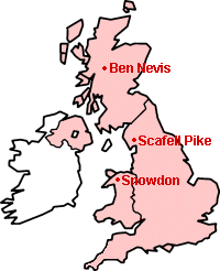
The mountains climbed, in order of elevation, are Ben Nevis
Ben Nevis
Ben Nevis is the highest mountain in the British Isles. It is located at the western end of the Grampian Mountains in the Lochaber area of the Scottish Highlands, close to the town of Fort William....
in Western Scotland
Scotland
Scotland is a country that is part of the United Kingdom. Occupying the northern third of the island of Great Britain, it shares a border with England to the south and is bounded by the North Sea to the east, the Atlantic Ocean to the north and west, and the North Channel and Irish Sea to the...
, 1344 metres (4,409 ft), Snowdon
Snowdon
Snowdon is the highest mountain in Wales, at an altitude of above sea level, and the highest point in the British Isles outside Scotland. It is located in Snowdonia National Park in Gwynedd, and has been described as "probably the busiest mountain in Britain"...
in North Wales
Wales
Wales is a country that is part of the United Kingdom and the island of Great Britain, bordered by England to its east and the Atlantic Ocean and Irish Sea to its west. It has a population of three million, and a total area of 20,779 km²...
, 1085 metres (3,560 ft), and Scafell Pike
Scafell Pike
Scafell Pike is the highest mountain in England at . It is located in Lake District National Park sometimes confused with the neighbouring Sca Fell, to which it is connected by the col of Mickledore...
in North-Western England
England
England is a country that is part of the United Kingdom. It shares land borders with Scotland to the north and Wales to the west; the Irish Sea is to the north west, the Celtic Sea to the south west, with the North Sea to the east and the English Channel to the south separating it from continental...
, 978 metres (3,209 ft). In all the challenge involves some 42 kilometres (26 mi) of ascent and descent, with total travel approaching 765 kilometres (475 mi). The challenge is usually undertaken starting with Ben Nevis, the highest, and for many the most distant.
There is no formal governing body of the National Three Peaks Challenge. Each year many organised attempts are made at the challenge with the aim of fundraising for charity, in which sponsorship is sought by participants, but many people are purely interested in the physical challenge and make attempts in small groups, usually with non-walkers performing a supporting function by doing the driving and having food ready.
Standard route
To take advantage of the good weather and long hours of daylight, most attempts are made in the summer months, and follow a common pattern, employed because it has proven to be the easiest way of achieving success. According to this method (times used here are very approximate and offer only a rough indication of the timescales involved), the challenge begins with the start of the climb up Ben Nevis at 17:00, with the summit being reached via the Pony Track at 20:00, and arrival at the bottom at 22:00. The Pony Track features approximately 1320 metres (4,331 ft) of vertical climb. The time of year is important because if Ben Nevis has to be climbed earlier to avoid nightfall on the way down, less time is available the next day unless Scafell Pike is begun in darkness prior to daybreak. Care must be taken to minimise turnaround time at the base of mountains; the usual practice is for food to be prepared by others in anticipation of the return of the climbers, and then eaten on the road after immediate departure for Scafell Pike.The trip down through Scotland to the Lake District
Lake District
The Lake District, also commonly known as The Lakes or Lakeland, is a mountainous region in North West England. A popular holiday destination, it is famous not only for its lakes and its mountains but also for its associations with the early 19th century poetry and writings of William Wordsworth...
is the longer of the two road journeys, taking perhaps six to seven hours depending on driving speeds. Walkers are strongly advised to get some sleep during this period. If Scafell Pike is reached at 04:30 it can be climbed via a choice of routes, arriving at the summit at 07:00. Walkers generally start at Wasdale Head
Wasdale Head
Wasdale Head is a small agricultural village in the Lake District National Park in Cumbria, England. The village claims to be home of the highest mountain , deepest lake , smallest church and biggest liar in England...
, although the route from Seathwaite may also be done in the time. While it may be the lowest peak of the three, Scafell Pike is often considered to be the hardest, possibly because it has to be climbed first thing in the morning after having rushed-up Ben Nevis the previous evening and having had little sleep in between, and possibly because the usual Wasdale route provides the steepest climb of all three mountains, with 900 metres (2,953 ft) of ascent over only 4 kilometres (2.5 mi). If care is taken to keep to the correct route it should be possible to depart by 08:30.
There follows a journey of several hours to Snowdonia
Snowdonia
Snowdonia is a region in north Wales and a national park of in area. It was the first to be designated of the three National Parks in Wales, in 1951.-Name and extent:...
, during which walkers are likely to feel tired, stiff and hungry, and all the while worrying that the time they have available for completing the third peak is slipping away. This is especially true of the last few miles to Snowdon, which are the slowest of them all due to the nature of the smaller A-roads approaching Llanberis
Llanberis
Llanberis is a village in Gwynedd, North Wales, lying on the southern banks of Llyn Padarn in Snowdonia. It takes its name from Saint Peris, an early Welsh saint.According to the United Kingdom Census 2001, the population of Llanberis was 1,954...
and the possibility of traffic bottlenecks from summer tourists. If Snowdon is reached at 13:30 the summit can be reached by the Pyg or Miners' tracks by 15:30, leaving an hour and a half to return to base within the time limit. The route from Pen-y-Pass features approximately 720 metres (2,362 ft) of vertical climb, totalling around 3000 metres (9,843 ft) of vertical climb on the challenge. Teams who for some reason lose time on an earlier stage may find themselves pushed to the limit of their abilities on Snowdon, particularly if they have picked up injuries or fatigue in particular areas over the course of the first two mountains. Being confined in a car or minibus between mountains does not help matters.
While participants do need to be reasonably fit to stand a realistic chance of success in the challenge, most active people, and particularly those who are young or used to hillwalking
Hillwalking
In the British Isles, the terms hillwalking or fellwalking are commonly used to describe the recreational outdoor activity of walking on hills and mountains, often with the intention of visiting their summits...
, should not be put off by the daunting prospect of climbing three famously high mountains in succession. British mountains are relatively small by international standards, and as long as the weather is conducive to walking (the conditions on Ben Nevis in particular are notoriously changeable) then 24 hours need not be an impossible time. In fact, doing the large amount of driving required, especially when combined with preparing food and other matters, is quite a challenge in itself. The great flaw in the Three Peaks Challenge is that success is to a great extent dependent on the speed of driving and the state of traffic. One major delay on, say the M6 or the A55, could seriously compromise well-laid plans.
Criticisms
As the popularity of the challenge has grown in recent years, it has been increasingly criticised by local residents and conservation bodies in the areas around the peaks. It has been blamed for an increase in traffic at unsociable hours in rural areas. Participants have also been accused of dumping litter, causing erosion by using short-cuts in an attempt to save time, and inconveniencing residents and other visitors by illegal or inconsiderate driving and parking of vehicles.A particular problem in Wasdale Head
Wasdale Head
Wasdale Head is a small agricultural village in the Lake District National Park in Cumbria, England. The village claims to be home of the highest mountain , deepest lake , smallest church and biggest liar in England...
, the usual starting point for Scafell Pike, is the lack of mains water; on occasion the influx of challengers has meant the limited water supply has been exhausted.
Another criticism is that, although money is raised for the charity of choice (with a proportion sometimes going to an organising company), these and similar challenges stretch the resources of other charities such as local mountain rescue teams. The event also presents road safety hazards due to driver tiredness, although these can be mitigated by using drivers who are not themselves walking.
A set of guidelines has been drawn up by the Institute of Fundraising
Institute of Fundraising
The Institute of Fundraising is a registered charity founded in 1983, and is the professional membership body for UK fundraising. The IoF's mission is to support fundraisers, through leadership, representation, standards-setting and education, to deliver excellent fundraising.- History :The IoF...
.
Amongst other things, this asks participants to:
- avoid weekends
- avoid the period from late June to mid July
- avoid arriving or departing settled areas between midnight and 5 am.
- limit events to 200 participants or fewer
Supporters of the events maintain that it is only a minority of badly behaved participants who cause problems, and that the benefits of the challenge to their charity outweigh the costs.
Three Peaks relay team run
In 1977, a team from Vauxhall Motors Athletic Club set a record for the Three Peaks run with a team of five runners. This followed the traditional Three Peaks run by starting and finishing at sea level and they ran around the clock as a relay team. The five runners covered the 470 miles (756.4 km) route in 54 hours, 57 minutes and 47 seconds. The record was broken in August 1981 by a five-man team of runners from the Territorial Army, also all members of Vauxhall Motors A.C. They took 18 minutes 33 seconds off the original record (i.e. 54 hours, 39 minutes and 14 seconds), starting with one foot in the sea at Fort William and ending with one foot in the sea at Caernarfon. As far as is known, this record still stands.Related challenges
- Three Peaks yacht raceThree peaks yacht raceThe Three Peaks Yacht Race is held each year in June in the United Kingdom since 1977. It is based on an idea of the late Bill Tilman, who had advocated a Three Peaks Challenge route without using motorised transport...
- Four Peaks Challenge, by including Northern IrelandNorthern IrelandNorthern Ireland is one of the four countries of the United Kingdom. Situated in the north-east of the island of Ireland, it shares a border with the Republic of Ireland to the south and west...
's Slieve DonardSlieve DonardSlieve Donard is a 850 m mountain in County Down, Northern Ireland. It is part of the Mourne Mountains and the highest peak in Northern Ireland and in the wider province of Ulster. It is the 19th highest peak on the island of Ireland...
, 849 metres (2,785 ft). - Five Peaks Challenge, aiming to climb the highest peak in each of England, Northern Ireland, Republic of Ireland, Scotland and Wales within 48 hours, by adding Slieve Donard and CarrantuohillCarrauntoohillCarrauntoohil or Carrantuohill is the highest peak in Ireland. Located in County Kerry, it is tall and is the central peak of the Macgillycuddy's Reeks range. There are two other peaks in this range higher than 1,000 m—Beenkeragh and Caher...
1038 metres (3,406 ft) in the Republic of IrelandRepublic of IrelandIreland , described as the Republic of Ireland , is a sovereign state in Europe occupying approximately five-sixths of the island of the same name. Its capital is Dublin. Ireland, which had a population of 4.58 million in 2011, is a constitutional republic governed as a parliamentary democracy,...
. In June 2002 the record for completing the challenge was set at 19 hours and 52 minutes. - 6 Peaks Challenge, by including SnaefellSnaefellSnaefell is the highest mountain and the only summit higher than on the Isle of Man, at above sea level. The summit is crowned by a train station, cafe, and several communications masts.- Views :...
in the Isle of ManIsle of ManThe Isle of Man , otherwise known simply as Mann , is a self-governing British Crown Dependency, located in the Irish Sea between the islands of Great Britain and Ireland, within the British Isles. The head of state is Queen Elizabeth II, who holds the title of Lord of Mann. The Lord of Mann is...
.
Further reading
- Marathon Runner (magazine), March / April 1982, Page 41, Three Peaks Relay by P. Ford