

National Register of Historic Places listings in Wayne County, Pennsylvania
Encyclopedia
This is intended to be a complete list of the properties and districts on the National Register of Historic Places
National Register of Historic Places
The National Register of Historic Places is the United States government's official list of districts, sites, buildings, structures, and objects deemed worthy of preservation...
in Wayne County
Wayne County, Pennsylvania
As of the census of 2000, there were 47,722 people, 18,350 households, and 12,936 families residing in the county. The population density was 65 people per square mile . There were 30,593 housing units at an average density of 42 per square mile...
, Pennsylvania
Pennsylvania
The Commonwealth of Pennsylvania is a U.S. state that is located in the Northeastern and Mid-Atlantic regions of the United States. The state borders Delaware and Maryland to the south, West Virginia to the southwest, Ohio to the west, New York and Ontario, Canada, to the north, and New Jersey to...
, United States
United States
The United States of America is a federal constitutional republic comprising fifty states and a federal district...
. The locations of National Register properties and districts for which the latitude and longitude coordinates are included below, may be seen in a Google map.
There are 17 properties and districts listed on the National Register in the county. One site is further designated as a National Historic Landmark
National Historic Landmark
A National Historic Landmark is a building, site, structure, object, or district, that is officially recognized by the United States government for its historical significance...
.
Current listings
| Landmark name | Image | Date listed | Location | City or Town | Summary | |
|---|---|---|---|---|---|---|
| 1 | Bellemonte Silk Mill | 230 Welwood Ave. 41°28′19"N 75°10′20"W |
Hawley Hawley, Pennsylvania Hawley is a borough in Wayne County, Pennsylvania, United States. The population was 1,211 at the 2010 census.- History :The borough was named for Irad Hawley, first president of the Pennsylvania Coal Company. Early industry centered around the transportation and support of nearby coal mining... |
New listing; refnum 10000407 | ||
| 2 | Bridge in Dreher Township | Legislative Route 171 over Haags Mill Creek 41°17′17"N 75°19′52"W |
Dreher Township | |||
| 3 | Damascus Historic District | Roughly Pennsylvania Route 371 Pennsylvania Route 371 Pennsylvania Route 371 is a 23.45-mile long state highway located in Susquehanna and Wayne Counties. The western terminus is at Route 171 / Route 374 near the community of Union Dale in Herrick Center... from Galilee Road to the Delaware River Delaware River The Delaware River is a major river on the Atlantic coast of the United States.A Dutch expedition led by Henry Hudson in 1609 first mapped the river. The river was christened the South River in the New Netherland colony that followed, in contrast to the North River, as the Hudson River was then... and adjacent part of Route 63027 south of Pennsylvania Route 371 41°42′37"N 75°4′15"W |
Damascus Township | |||
| 4 | Delaware and Hudson Canal Delaware and Hudson Canal The Delaware and Hudson Canal was the first venture of the Delaware and Hudson Canal Company, which later developed the Delaware and Hudson Railway... |
Delaware and Hudson Canal | Honesdale Honesdale, Pennsylvania Honesdale is a borough in and the county seat of Wayne County, Pennsylvania, United States. It is located northeast of Scranton. The population was 4,874 at the 2000 census.... |
Extends into Pike County National Register of Historic Places listings in Pike County, Pennsylvania This is a list of the National Register of Historic Places listings in Pike County, Pennsylvania.This is intended to be a complete list of the properties and districts on the National Register of Historic Places in Pike County, Pennsylvania, United States... |
||
| 5 | Eugene Dorflinger Estate | U.S. Route 6 U.S. Route 6 U.S. Route 6 , also called the Grand Army of the Republic Highway, a name that honors an American Civil War veterans association, is a main route of the U.S. Highway system, running east-northeast from Bishop, California to Provincetown, Massachusetts. Until 1964, it continued south from Bishop to... and Charles Street in White Mills 41°31′32"N 75°12′12"W |
Texas Township | |||
| 6 | Equinunk Historic District | Generally following Pennsylvania Route 191 Pennsylvania Route 191 Pennsylvania Route 191 is a -long state highway in the U.S. state of Pennsylvania. The route, a major non-freeway corridor connecting the Lehigh Valley to The Poconos in eastern Pennsylvania, is designated from U.S... , Pine Mill, Lordville, and Grocery Hill Roads in Equinunk 41°51′18"N 75°13′37"W |
Buckingham Buckingham Township, Wayne County, Pennsylvania Buckingham Township is a township in Wayne County, Pennsylvania, United States. The population was 656 at the 2000 census.-Geography:According to the United States Census Bureau, the township has a total area of , of which, of it is land and of it is water.-Demographics:As of the census of 2000,... and Manchester Manchester Township, Wayne County, Pennsylvania Manchester Township is a township in Wayne County, Pennsylvania, United States. The population was 888 at the 2000 census.-Geography:According to the United States Census Bureau, the township has a total area of 45.0 square miles , of which, 44.2 square miles of it is land and... Townships |
|||
| 7 | Hill's Sawmill | South of Equinunk off Pennsylvania Route 191 Pennsylvania Route 191 Pennsylvania Route 191 is a -long state highway in the U.S. state of Pennsylvania. The route, a major non-freeway corridor connecting the Lehigh Valley to The Poconos in eastern Pennsylvania, is designated from U.S... 41°45′9"N 75°11′36"W |
Damascus Township | |||
| 8 | Honesdale Residential Historic District | Roughly bounded by the Lackawaxen River Lackawaxen River The Lackawaxen River is a tributary of the Delaware River in northeastern Pennsylvania in the United States. The river flows through a largely rural area in the northern Pocono Mountains, draining an area of approximately .... , Dyberry Creek Dyberry Creek Dyberry Creek is a tributary of the Lackawaxen River in Wayne County, Pennsylvania, in the United States.Dyberry Creek joins the Lackawaxen River at Honesdale. The creek is formed by the confluence of two branches: the east and west. The creek and its branches are often stocked with... , the Dyberry Cemetery, and Overlook and 18th Streets 41°34′51"N 75°15′35"W |
Honesdale Honesdale, Pennsylvania Honesdale is a borough in and the county seat of Wayne County, Pennsylvania, United States. It is located northeast of Scranton. The population was 4,874 at the 2000 census.... |
|||
| 9 | Lacawac | East of Ledgedale 41°22′43"N 75°17′40"W |
Paupack and Salem Salem Township, Wayne County, Pennsylvania Salem Township is a township in Wayne County, Pennsylvania, United States. The population was 4,271 at the 2010 census.-Geography:According to the United States Census Bureau, the township has a total area of 31.5 square miles , of which, 30.6 square miles of it is land and... Townships |
|||
| 10 | Milanville Historic District | Roughly Legislative Route 63027 from the junction with Legislative Route 63029 east to Skinner's Falls Bridge via Bridge Approach Road, in Milanville 41°40′16"N 75°3′48"W |
Damascus Township | |||
| 11 | Milanville-Skinners Falls Bridge | 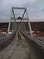 |
Legislative Route 63027 over the Delaware River Delaware River The Delaware River is a major river on the Atlantic coast of the United States.A Dutch expedition led by Henry Hudson in 1609 first mapped the river. The river was christened the South River in the New Netherland colony that followed, in contrast to the North River, as the Hudson River was then... at Milanville 41°40′10"N 75°3′31"W |
Damascus Township | Extends into Cochecton Cochecton, New York Cochecton is a town located in west-central Sullivan County, New York, USA. The population was 1,328 at the 2000 census. The name is an aboriginal word for "low land."... in Sullivan County, New York |
|
| 12 | J.S. O'Connor American Rich Cut Glassware Factory | 120 Falls Avenue 41°28′31"N 75°10′17"W |
Hawley Hawley, Pennsylvania Hawley is a borough in Wayne County, Pennsylvania, United States. The population was 1,211 at the 2010 census.- History :The borough was named for Irad Hawley, first president of the Pennsylvania Coal Company. Early industry centered around the transportation and support of nearby coal mining... |
|||
| 13 | Octagon Stone Schoolhouse | 1 miles (1.6 km) southwest of South Canaan 41°29′42"N 75°25′53"W |
South Canaan Township | |||
| 14 | Patriotic Order Sons of America Washington Camp 422 | 465 South Sterling Road 41°16′27.7"N 75°20′11"W |
Dreher Township | |||
| 15 | Starlight Station, New York, Ontario, and Western Railway | O&W Road northeast of Depot Hill Road, Starlight 41°54′14"N 75°19′46"W |
Buckingham Township Buckingham Township, Wayne County, Pennsylvania Buckingham Township is a township in Wayne County, Pennsylvania, United States. The population was 656 at the 2000 census.-Geography:According to the United States Census Bureau, the township has a total area of , of which, of it is land and of it is water.-Demographics:As of the census of 2000,... |
|||
| 16 | Wilmot House | 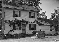 |
Wayne Street 41°36′46"N 75°17′3"W |
Bethany Bethany, Pennsylvania Bethany is a borough in Wayne County, Pennsylvania, United States. The population was 246 at the 2010 census.-Geography:Bethany is located at .... |
||
| 17 | Wilmot Mansion | Wayne and Sugar Streets 41°36′47"N 75°17′6"W |
Bethany Bethany, Pennsylvania Bethany is a borough in Wayne County, Pennsylvania, United States. The population was 246 at the 2010 census.-Geography:Bethany is located at .... |
Former listing
| Landmark name | Image | Date listed | Location | City or Town | Summary | |
|---|---|---|---|---|---|---|
| 1 | Stone Arch Bridge | Starrucca Creek Starrucca Creek Starrucca Creek is an tributary of the Susquehanna River in Susquehanna and Wayne counties, Pennsylvania, in the United States.The tributary Shadigee Creek joins Starrucca Creek just downstream of the borough of Starrucca.... |
Starrucca Starrucca, Pennsylvania Starrucca is a borough in Wayne County, Pennsylvania, United States. The population was 173 at the 2010 census.-Geography:Starrucca is located at .... |
See also
- List of National Historic Landmarks in Pennsylvania
- National Register of Historic Places listings in Pennsylvania
- List of Pennsylvania state historical markers in Wayne County