

List of Pennsylvania state historical markers in Wayne County
Encyclopedia
This is intended to be a complete list of the official state historical markers placed in Wayne County, Pennsylvania
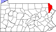
Wayne County, Pennsylvania
As of the census of 2000, there were 47,722 people, 18,350 households, and 12,936 families residing in the county. The population density was 65 people per square mile . There were 30,593 housing units at an average density of 42 per square mile...
by the Pennsylvania Historical and Museum Commission
Pennsylvania Historical and Museum Commission
The Pennsylvania Historical and Museum Commission is the governmental agency of the Commonwealth of Pennsylvania responsible for the collection, conservation and interpretation of Pennsylvania's historic heritage...
(PHMC). The locations of the historical markers, as well as the latitude and longitude coordinates as provided by the PHMC's database, are included below when available. There are 15 historical markers located in Wayne County.
Historical markers
| Marker title | Image | Date dedicated | Location | Marker type | Topics |
|---|---|---|---|---|---|
| Cushetunk | SR 1004 N of Milanville (MISSING) °N °W |
Roadside | American Revolution, Early Settlement, Government & Politics, Government & Politics 18th Century, Native American | ||
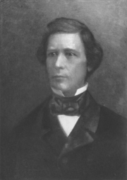
| David Wilmot David Wilmot David Wilmot was a U.S. political figure. He was a sponsor and eponym of the Wilmot Proviso which aimed to ban slavery in land gained from Mexico in the Mexican-American War of 1846–1848. Wilmot was a Democrat, a Free Soiler, and a Republican during his political career... |
 |
PA 670 1.6 mi. NW of PA 90, Honesdale (Missing) 41.61265°N 75.28388°W |
Roadside | Government & Politics, Government & Politics 19th Century, Writers | |
| David Wilmot David Wilmot David Wilmot was a U.S. political figure. He was a sponsor and eponym of the Wilmot Proviso which aimed to ban slavery in land gained from Mexico in the Mexican-American War of 1846–1848. Wilmot was a Democrat, a Free Soiler, and a Republican during his political career... |
|
395 Old Wayne St., S of Sugar St., off Pa. 670 at Bethany, not accessible from "new" Wayne St. (a private drive) °N °W |
Roadside | African American, Government & Politics, Government & Politics 19th Century | |
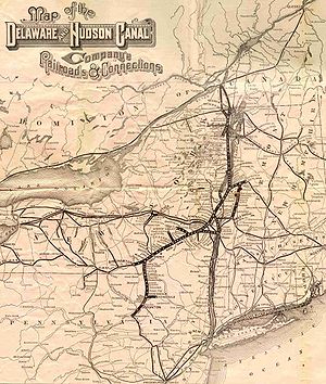
| Delaware & Hudson Canal Delaware and Hudson Railway The Delaware and Hudson Railway is a railroad that operates in the northeastern United States. Since 1991 it has been a subsidiary of the Canadian Pacific Railway, although CPR has assumed all operations and the D&H does not maintain any locomotives or rolling stock.It was formerly an important... |
 |
Main St. (US 6) & 8th St., at historical society, Honesdale 41.57222°N 75.25555°W |
Roadside | Canals, Coal, Navigation, Railroads, Transportation | |
| Dorflinger Glass Works | Main St. (US 6 - Texas Palmyra Hwy.) & Elizabeth St. at S end of White Mills 41.52642°N 75.20353°W |
Roadside | Business & Industry, Glass | ||
| Honesdale Honesdale, Pennsylvania Honesdale is a borough in and the county seat of Wayne County, Pennsylvania, United States. It is located northeast of Scranton. The population was 4,874 at the 2000 census.... |
Grandview Ave. (US 6) near #20, at billboard, SE of Honesdale 41.55642°N 75.24068°W |
Roadside | Canals, Cities & Towns, Coal, Professions & Vocations, Transportation | ||
| Honesdale Honesdale, Pennsylvania Honesdale is a borough in and the county seat of Wayne County, Pennsylvania, United States. It is located northeast of Scranton. The population was 4,874 at the 2000 census.... |
W Park St. (US 6) & Meadow Ln. west of Honesdale (on left heading west) 41.57756°N 75.27254°W |
Roadside | Cities & Towns | ||
| Lincoln Nomination | 115 9th St., Honesdale 41.57336°N 75.25586°W |
Roadside | Abraham Lincoln, Government & Politics, Government & Politics 19th Century | ||
| Pennsylvania Pennsylvania The Commonwealth of Pennsylvania is a U.S. state that is located in the Northeastern and Mid-Atlantic regions of the United States. The state borders Delaware and Maryland to the south, West Virginia to the southwest, Ohio to the west, New York and Ontario, Canada, to the north, and New Jersey to... |
 |
n/a | PA 191 between PA 370 and the state line (Missing) °N °W |
Roadside | Government & Politics, Government & Politics 17th Century, William Penn |
| Samuel Meredith Samuel Meredith Samuel Meredith was an American merchant from Philadelphia, Pennsylvania. He was a delegate for Pennsylvania to the Continental Congress from 1786 to 1788... |
Great Bend Turnpk. (PA 371) & Bethany Turnpk. (PA 670) at fork, Pleasant Mount (near Welcome sign) 41.74°N 75.43433°W |
Roadside | American Revolution, Government & Politics, Government & Politics 18th Century | ||
| Samuel Meredith Samuel Meredith Samuel Meredith was an American merchant from Philadelphia, Pennsylvania. He was a delegate for Pennsylvania to the Continental Congress from 1786 to 1788... |
PA 371/670 (Great Bend Trnpk.) & Belmont and Easton Trnpk. at Belmont Corner W of Pleasant Mount 41.74051°N 75.45615°W |
Roadside | Government & Politics, Government & Politics 18th Century | ||
| Sarah Mary Benjamin | Old Newburgh Trnpk. / Great Bend Trnpk. (PA 371) at Brannigan Rd., just S of Pleasant Mount (West Hill), near N-E PA Phone Co. 41.73999°N 75.43925°W |
Roadside | American Revolution, Military, Women | ||
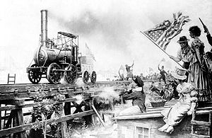
| Stourbridge Lion Stourbridge Lion The Stourbridge Lion was a railroad steam locomotive. It was not only the first locomotive to be operated in the United States, it was also one of the first locomotives to operate outside of England, where it was manufactured in 1828.... |
 |
US 6 / PA 191 (Main St.) at Park St., Honesdale, by bridge 41.57693°N 75.25835°W |
Roadside | Railroads, Transportation | |
| Stourbridge Lion Stourbridge Lion The Stourbridge Lion was a railroad steam locomotive. It was not only the first locomotive to be operated in the United States, it was also one of the first locomotives to operate outside of England, where it was manufactured in 1828.... |
n/a | Main St. (US 6) & 8th St., at historical soc., Honesdale 41.57223°N 75.25554°W |
Roadside | Railroads, Transportation | |
| Wayne County Wayne County, Pennsylvania As of the census of 2000, there were 47,722 people, 18,350 households, and 12,936 families residing in the county. The population density was 65 people per square mile . There were 30,593 housing units at an average density of 42 per square mile... |
 |
County Courthouse, 925 Court St., Honesdale 41.57455°N 75.25407°W |
City | Government & Politics, Government & Politics 18th Century |
See also
- List of Pennsylvania state historical markers
- National Register of Historic Places listings in Wayne County, PennsylvaniaNational Register of Historic Places listings in Wayne County, PennsylvaniaThis is a list of the National Register of Historic Places listings in Wayne County, Pennsylvania.This is intended to be a complete list of the properties and districts on the National Register of Historic Places in Wayne County, Pennsylvania, United States...