
National Register of Historic Places listings in Greenville County, South Carolina
Encyclopedia

This is intended to be a complete list of the properties and districts on the National Register of Historic Places
National Register of Historic Places
The National Register of Historic Places is the United States government's official list of districts, sites, buildings, structures, and objects deemed worthy of preservation...
in Greenville County
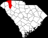
Greenville County, South Carolina
- External Links :*...
, South Carolina
South Carolina
South Carolina is a state in the Deep South of the United States that borders Georgia to the south, North Carolina to the north, and the Atlantic Ocean to the east. Originally part of the Province of Carolina, the Province of South Carolina was one of the 13 colonies that declared independence...
, United States
United States
The United States of America is a federal constitutional republic comprising fifty states and a federal district...
. The locations of National Register properties and districts for which the latitude and longitude coordinates are included below, may be seen in a map.
There are 69 properties and districts listed on the National Register in the county. The city of Greenville
Greenville, South Carolina
-Law and government:The city of Greenville adopted the Council-Manager form of municipal government in 1976.-History:The area was part of the Cherokee Nation's protected grounds after the Treaty of 1763, which ended the French and Indian War. No White man was allowed to enter, though some families...
is the location of 39 of these properties and districts; they are listed separately
National Register of Historic Places listings in Greenville, South Carolina
This is a list of the National Register of Historic Places listings in Greenville, South Carolina.This is intended to be a complete list of the properties and districts on the National Register of Historic Places in Greenville, South Carolina, United States...
, while the 30 properties and districts in the remaining parts of the county are listed here. Another property in Greenville County outside of Greenville was once listed but has been removed.
Current listings
| Landmark name | Image | Date listed | Location | City or Town | Summary | |
|---|---|---|---|---|---|---|
| 1 | South of Greer on South Carolina Highway 14 South Carolina Highway 14 Highway 14 is a state highway located in the U.S. state of South Carolina. It begins at an intersection with U.S. 76 in Laurens, South Carolina, and ends at I-26 near Landrum.-History:... 34°51′18"N 82°13′41"W |
Greer Greer, South Carolina Greer is a city in Greenville and Spartanburg counties in the U.S. state of South Carolina, between the cities of Greenville and Spartanburg. The population was 25,515 at the 2010 census. It is projected to hit 30,000 within 4 years. Each day, more than three times that number of people pass... |
||||
| 2 | East of Greenville on South Carolina Highway 14 South Carolina Highway 14 Highway 14 is a state highway located in the U.S. state of South Carolina. It begins at an intersection with U.S. 76 in Laurens, South Carolina, and ends at I-26 near Landrum.-History:... 34°50′53"N 82°14′4"W |
Greenville Greenville, South Carolina -Law and government:The city of Greenville adopted the Council-Manager form of municipal government in 1976.-History:The area was part of the Cherokee Nation's protected grounds after the Treaty of 1763, which ended the French and Indian War. No White man was allowed to enter, though some families... |
||||
| 3 | Burdette Building Burdette Building The Burdette Building, also known as Burdette Hardware Building or B.W. Burdette Building, in Simpsonville, South Carolina, was listed on the U.S. National Register of Historic Places in 2003.... |
104 E. Curtis St. 34°44′14"N 82°15′19"W |
Simpsonville Simpsonville, South Carolina Simpsonville is a city in Greenville County, South Carolina, United States. It is part of the Greenville–Mauldin–Easley Metropolitan Statistical Area. The population was 14,352 at the 2000 census, and estimated at 17,778 in 2009... |
|||
| 4 | Campbell's Covered Bridge Campbell's Covered Bridge Campbell's Covered Bridge is a wooden covered bridge in northeastern Greenville County, South Carolina, near the small town of Gowensville.It is the last remaining covered bridge in South Carolina. It is located off Pleasant Hill Road, crossing Beaverdam Creek.It is owned by Greenville County which... |
123 Campbell Covered Bridge Rd. 35°5′9"N 82°15′51"W |
Gowensville | |||
| 5 | Cannon Building Cannon Building (Fountain Inn, South Carolina) Cannon Building in Fountain Inn, South Carolina is a building built in 1880. It was listed on the National Register of Historic Places in 2005.... |
100 N. Main St. 34°41′37"N 82°11′59"W |
Fountain Inn Fountain Inn, South Carolina Fountain Inn is a city in Greenville and Laurens counties in the U.S. state of South Carolina. The population was 6,017 at the 2000 census. It is part of the Greenville–Mauldin–Easley Metropolitan Statistical Area.-Geography:... |
|||
| 6 | Cureton-Huff House | Southwest of Simpsonville off South Carolina Highway 176 34°41′34"N 82°20′2"W |
Simpsonville Simpsonville, South Carolina Simpsonville is a city in Greenville County, South Carolina, United States. It is part of the Greenville–Mauldin–Easley Metropolitan Statistical Area. The population was 14,352 at the 2000 census, and estimated at 17,778 in 2009... |
|||
| 7 | Davenport House | 100 Randall St. 34°56′10"N 82°13′37"W |
Greer Greer, South Carolina Greer is a city in Greenville and Spartanburg counties in the U.S. state of South Carolina, between the cities of Greenville and Spartanburg. The population was 25,515 at the 2010 census. It is projected to hit 30,000 within 4 years. Each day, more than three times that number of people pass... |
|||
| 8 | Fairview Presbyterian Church Fairview Presbyterian Church (Fountain Inn, South Carolina) Fairview Presbyterian Church is a historic church in Fountain Inn, South Carolina.It was built in 1858 and added to the National Register in 1977.... |
West of Fountain Inn off South Carolina Highway 418 South Carolina Highway 418 South Carolina Highway 418 is a 24.6 mile, east-west route between US 25 in southern Greenville and SC 101/SC 146 in southern Spartanburg counties, and running through northern Laurens, in upstate South Carolina.-Route description:... 34°38′37"N 82°15′5"W |
Fountain Inn Fountain Inn, South Carolina Fountain Inn is a city in Greenville and Laurens counties in the U.S. state of South Carolina. The population was 6,017 at the 2000 census. It is part of the Greenville–Mauldin–Easley Metropolitan Statistical Area.-Geography:... |
|||
| 9 | Fountain Inn High School | 34°41′43.83"N 82°12′5.91"W | ||||
| 10 | Fountain Inn Principal's House and Teacherage | 34°41′47"N 82°11′33"W | ||||
| 11 | Gilreath's Mill | 4 miles northwest of Greer on South Carolina Highway 101 South Carolina Highway 101 South Carolina Highway 101 is a state route in Greenville, Spartanburg, and Laurens counties. Its northern terminus is at a junction with SC 11 near Landrum, SC, and its southern terminus is at a junction with US 76 in Hickory Tavern, SC.-Route description:The north terminus of South Carolina... 34°58′23"N 82°16′44"W |
Greer Greer, South Carolina Greer is a city in Greenville and Spartanburg counties in the U.S. state of South Carolina, between the cities of Greenville and Spartanburg. The population was 25,515 at the 2010 census. It is projected to hit 30,000 within 4 years. Each day, more than three times that number of people pass... |
|||
| 12 | South Carolina Highway 11 South Carolina Highway 11 The Cherokee Foothills National Scenic Highway winds its way through Upstate South Carolina. Following the southernmost peaks of the Blue Ridge Mountains, the route is surrounded with peach orchards, quaint villages, and parks... at U.S. Route 25 U.S. Route 25 U.S. Route 25 is a north–south United States highway that runs for from Brunswick, Georgia to the Ohio state line in Covington, Kentucky.-Georgia:... 35°5′19"N 82°27′8"W |
Travelers Rest Travelers Rest, South Carolina Travelers Rest is a city in Greenville County, South Carolina, United States. The population was 4,099 at the 2000 census. It is part of the Greenville–Mauldin–Easley Metropolitan Statistical Area. "TR", as the city is known around the area, is just north of Greenville... |
||||
| 13 | Greer Depot | 311 Trade St. 34°56′10"N 82°13′33"W |
Greer Greer, South Carolina Greer is a city in Greenville and Spartanburg counties in the U.S. state of South Carolina, between the cities of Greenville and Spartanburg. The population was 25,515 at the 2010 census. It is projected to hit 30,000 within 4 years. Each day, more than three times that number of people pass... |
|||
| 14 | Greer Downtown Historic District | Roughly bounded by Trade, E. Poinsett, Randall, Victoria, and N. Main Sts. 34°56′16"N 82°13′43"W |
Greer Greer, South Carolina Greer is a city in Greenville and Spartanburg counties in the U.S. state of South Carolina, between the cities of Greenville and Spartanburg. The population was 25,515 at the 2010 census. It is projected to hit 30,000 within 4 years. Each day, more than three times that number of people pass... |
|||
| 15 | Greer Post Office | 106 S Main St. 34°56′18.7"N 82°13′37.6"W |
Greer Greer, South Carolina Greer is a city in Greenville and Spartanburg counties in the U.S. state of South Carolina, between the cities of Greenville and Spartanburg. The population was 25,515 at the 2010 census. It is projected to hit 30,000 within 4 years. Each day, more than three times that number of people pass... |
|||
| 16 | Hopkins Farm | 3717 Fork Shoals Rd. 34°38′53.05"N 82°18′29.62"W |
Simpsonville Simpsonville, South Carolina Simpsonville is a city in Greenville County, South Carolina, United States. It is part of the Greenville–Mauldin–Easley Metropolitan Statistical Area. The population was 14,352 at the 2000 census, and estimated at 17,778 in 2009... |
|||
| 17 | 401 W. Poinsett St. 34°56′25"N 82°14′5"W |
Greer Greer, South Carolina Greer is a city in Greenville and Spartanburg counties in the U.S. state of South Carolina, between the cities of Greenville and Spartanburg. The population was 25,515 at the 2010 census. It is projected to hit 30,000 within 4 years. Each day, more than three times that number of people pass... |
||||
| 18 | McBee Methodist Church | Main St. 34°46′0"N 82°21′10"W |
Conestee | |||
| 19 | McDowell House | 500 N Main St. 34°41′53"N 82°12′17"W |
Fountain Inn Fountain Inn, South Carolina Fountain Inn is a city in Greenville and Laurens counties in the U.S. state of South Carolina. The population was 6,017 at the 2000 census. It is part of the Greenville–Mauldin–Easley Metropolitan Statistical Area.-Geography:... |
|||
| 20 | Monaghan Mill | 201 Smythe St. 34°52′0"N 82°25′27"W |
City View City View, South Carolina City View is a census-designated place in Greenville County, South Carolina, United States. The population was 1,254 at the 2000 census. It is part of the Greenville–Mauldin–Easley Metropolitan Statistical Area.-Geography:... |
|||
| 21 | Paris Mountain State Park Historic District | 2401 State Park Rd. 34°56′25"N 82°23′39"W |
Greenville Greenville, South Carolina -Law and government:The city of Greenville adopted the Council-Manager form of municipal government in 1976.-History:The area was part of the Cherokee Nation's protected grounds after the Treaty of 1763, which ended the French and Indian War. No White man was allowed to enter, though some families... |
|||
| 22 | Pelham Mills Site (38GR165) | Address Restricted | Pelham | |||
| 23 | Poinsett Bridge Poinsett Bridge Poinsett Bridge, which is named for Joel Roberts Poinsett, was built in 1820 as part of a road from Columbia, South Carolina to Saluda Mountain. It is a stone bridge. It is no longer in use, but it is still largely intact. It is part of the Poinsett Bridge Heritage Preserve. In the future, a... |
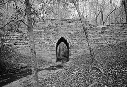 |
About 4 miles north of Tigerville on County Road 42 35°7′47"N 82°23′6"W |
Tigerville Tigerville, South Carolina Tigerville is a Census-designated place in Greenville County, South Carolina, United States. According to the 2010 United States Census the population is 1,312. It lies north of Taylors, northeast of Travelers Rest, and northwest of Greer... |
||
| 24 | South Carolina Highway 414, 1.8 miles west of U.S. Route 25 U.S. Route 25 U.S. Route 25 is a north–south United States highway that runs for from Brunswick, Georgia to the Ohio state line in Covington, Kentucky.-Georgia:... 35°2′7"N 82°27′31"W |
Travelers Rest Travelers Rest, South Carolina Travelers Rest is a city in Greenville County, South Carolina, United States. The population was 4,099 at the 2000 census. It is part of the Greenville–Mauldin–Easley Metropolitan Statistical Area. "TR", as the city is known around the area, is just north of Greenville... |
||||
| 25 | Simpsonville Baptist Church Simpsonville Baptist Church Simpsonville Baptist Church is a historic church at 106 Church Street in Simpsonville, South Carolina.It was built in 1913 and added to the National Register in 1992.... |
106 Church St. 34°44′21"N 82°15′10"W |
Simpsonville Simpsonville, South Carolina Simpsonville is a city in Greenville County, South Carolina, United States. It is part of the Greenville–Mauldin–Easley Metropolitan Statistical Area. The population was 14,352 at the 2000 census, and estimated at 17,778 in 2009... |
|||
| 26 | Tullyton | 606 Hickory Tavern Rd. 34°36′24"N 82°13′57"W |
Fountain Inn Fountain Inn, South Carolina Fountain Inn is a city in Greenville and Laurens counties in the U.S. state of South Carolina. The population was 6,017 at the 2000 census. It is part of the Greenville–Mauldin–Easley Metropolitan Statistical Area.-Geography:... |
|||
| 27 | 211 N. Main St. 34°56′29"N 82°13′31"W |
Greer Greer, South Carolina Greer is a city in Greenville and Spartanburg counties in the U.S. state of South Carolina, between the cities of Greenville and Spartanburg. The population was 25,515 at the 2010 census. It is projected to hit 30,000 within 4 years. Each day, more than three times that number of people pass... |
||||
| 28 | 305 N. Main St. 34°56′34"N 82°13′30"W |
Greer Greer, South Carolina Greer is a city in Greenville and Spartanburg counties in the U.S. state of South Carolina, between the cities of Greenville and Spartanburg. The population was 25,515 at the 2010 census. It is projected to hit 30,000 within 4 years. Each day, more than three times that number of people pass... |
||||
| 29 | 405 N. Weston St. 34°41′51"N 82°12′9"W |
Fountain Inn Fountain Inn, South Carolina Fountain Inn is a city in Greenville and Laurens counties in the U.S. state of South Carolina. The population was 6,017 at the 2000 census. It is part of the Greenville–Mauldin–Easley Metropolitan Statistical Area.-Geography:... |
||||
| 30 | Woodside Cotton Mill Village Historic District | Woodside Ave. and E. Main St. 34°51′12"N 82°25′47"W |
Woodside |
Former listing
| Landmark name | Image | Dates | Location | City or Town | Summary | |
|---|---|---|---|---|---|---|
| 1 | Piedmont Number One Piedmont Number One Piedmont Number One is a former textile plant and former National Historic Landmark in Piedmont, Greenville County, South Carolina. It burned in 1983.-Piedmont Manufacturing Company:... |
.jpg) |
(delisted) | Main Street | Piedmont Piedmont, South Carolina Piedmont is a census-designated place along the Saluda River in Anderson and Greenville counties in the U.S. state of South Carolina. The population was 4,684 at the 2000 census.... |
Burned in 1983. |
See also
- List of National Historic Landmarks in South Carolina
- National Register of Historic Places listings in South Carolina