
South Carolina Highway 11
Encyclopedia
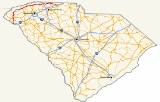
The Cherokee Foothills National Scenic Highway (S.C. 11) winds its way through Upstate South Carolina. Following the southernmost peaks of the Blue Ridge Mountains
, the route is surrounded with peach orchards, quaint villages, and parks. It is an alternative to Interstate 85
and has been featured by such publications as National Geographic, Rand McNally
and Southern Living
.
" or "Keowee Path," this road was the route used by the Cherokee Indians and the English and French fur traders and stretched from Tennessee to Charleston, South Carolina. This National Scenic Byway
winds its way through The Upstate and passes through some towns, such as Walhalla
, Marietta, Campobello
, Chesnee
, and Gaffney
. Echoes of the area's Cherokee heritage can still be heard in places and river names like Seneca, Savannah
, Keowee
, Jocassee
, Enoree
, Toxaway
, Tugaloo
, Tokena, and Eastatoee.
In the city of Gaffney
, east of I-85
, S.C. 11 is known as "Floyd Baker Boulevard," which is a well-known street name in The Upstate. This section of Highway 11 is a vast contrast to the rest of the route. At this point the highway becomes heavily congested and developed. Gaffney is also the biggest town along the route.
in southern Oconee County, 0.6 mi (1 km) from the South Carolina
and Georgia
border.
(EXIT 1;Southern terminus) near Oakway (short multiplex) near Westminster
near Walhalla
outside of West Union
in Salem
outside of Nine Times near Pickens
near Cleveland near Tigerville
outside of Tigerville
in Gowensville in Campobello
near Campobello
(EXIT 5) in New Prospect in Chesnee
near Gaffney
(EXIT 92) in Gaffney
(Northern terminus)
Blue Ridge Mountains
The Blue Ridge Mountains are a physiographic province of the larger Appalachian Mountains range. This province consists of northern and southern physiographic regions, which divide near the Roanoke River gap. The mountain range is located in the eastern United States, starting at its southern-most...
, the route is surrounded with peach orchards, quaint villages, and parks. It is an alternative to Interstate 85
Interstate 85
Interstate 85 is a major interstate highway in the Southeastern United States. Its current southern terminus is at an interchange with Interstate 65 in Montgomery, Alabama; its northern terminus interchanges with Interstate 95 in Petersburg, Virginia, near Richmond...
and has been featured by such publications as National Geographic, Rand McNally
Rand McNally
Rand McNally is an American publisher of maps, atlases, textbooks, and globes for travel, reference, commercial, and educational uses. It also provides online consumer street maps and directions, as well as commercial transportation routing software and mileage data...
and Southern Living
Southern Living
Southern Living is a widely read lifestyle magazine aimed at readers in the Southern United States featuring recipes, house plans, and information about Southern culture and travel...
.
History
The current highway was once part of the "Cherokee PathCherokee Path
The Cherokee Path was the primary route from Charleston to Columbia, South Carolina in Colonial America, connecting all of the Cherokee territories.-History:In the 17th century the Cherokee Path was used by English and French fur traders....
" or "Keowee Path," this road was the route used by the Cherokee Indians and the English and French fur traders and stretched from Tennessee to Charleston, South Carolina. This National Scenic Byway
National Scenic Byway
A National Scenic Byway is a road recognized by the United States Department of Transportation for its archeological, cultural, historic, natural, recreational, and/or scenic qualities. The program was established by Congress in 1991 to preserve and protect the nation's scenic but often...
winds its way through The Upstate and passes through some towns, such as Walhalla
Walhalla, South Carolina
Walhalla is a mountain city in Oconee County, South Carolina, United States. It is located from Clemson University in Clemson, South Carolina and is also located in the Appalachian Mountains of South Carolina. The population was 3,801 at the 2000 census. It is the county seat of Oconee County...
, Marietta, Campobello
Campobello, South Carolina
Campobello is a town in Spartanburg County, South Carolina, along the South Pacolet River. The population was 502 at the 2010 census.-Geography:Campobello is located at ....
, Chesnee
Chesnee, South Carolina
Chesnee is a city in Cherokee and Spartanburg counties in the U.S. state of South Carolina. The population was 868 as of the 2010 census.-Geography:Chesnee is located at ....
, and Gaffney
Gaffney, South Carolina
Gaffney is a city in and the county seat of Cherokee County, South Carolina, United States, in the upstate region of South Carolina. Gaffney is also sometimes referred to as the Peach capital of South Carolina. The population was 12,414 at the 2010 census...
. Echoes of the area's Cherokee heritage can still be heard in places and river names like Seneca, Savannah
Savannah River
The Savannah River is a major river in the southeastern United States, forming most of the border between the states of South Carolina and Georgia. Two tributaries of the Savannah, the Tugaloo River and the Chattooga River, form the northernmost part of the border...
, Keowee
Lake Keowee
Lake Keowee is a man–made reservoir in the United States in the state of South Carolina shaped somewhat like a Christmas tree. It is notable for having been created to serve the needs of a power utility called the Duke Energy company as well as public recreational purposes...
, Jocassee
Lake Jocassee
Lake Jocassee is a , deep reservoir located in northwest South Carolina created by the state in partnership with Duke Power in 1973. The lake is commonly known for the clean and cold Appalachian mountain rivers that feed the lake to keep its waters cool and clear water visibilities year-round. ...
, Enoree
Enoree River
The Enoree River is a tributary of the Broad River, 85 mi long, in northwestern South Carolina in the United States . Via the Broad and Congaree Rivers, it is part of the watershed of the Santee River, which flows to the Atlantic Ocean ....
, Toxaway
Toxaway River
The Toxaway River is a waterway that flows south from headwaters in Transylvania County, North Carolina, into Lake Toxaway and over Toxaway Falls, after which it crosses into South Carolina and enters Lake Jocassee, the reservoir behind Lake Jocassee Dam....
, Tugaloo
Tugaloo River
The Tugaloo River is a river bordering the U.S. states of Georgia and South Carolina. It is fed by the Tallulah River and the Chattooga River, which each form an arm of Lake Tugalo, on the edge of Georgia's Tallulah Gorge State Park. The Tugaloo then flows out of the lake via Tugaloo Dam,...
, Tokena, and Eastatoee.
In the city of Gaffney
Gaffney, South Carolina
Gaffney is a city in and the county seat of Cherokee County, South Carolina, United States, in the upstate region of South Carolina. Gaffney is also sometimes referred to as the Peach capital of South Carolina. The population was 12,414 at the 2010 census...
, east of I-85
Interstate 85 in South Carolina
In the U.S. state of South Carolina, Interstate 85 runs northeast-southwest through Greenville and Spartanburg. It follows the general corridor of U.S. Route 29...
, S.C. 11 is known as "Floyd Baker Boulevard," which is a well-known street name in The Upstate. This section of Highway 11 is a vast contrast to the rest of the route. At this point the highway becomes heavily congested and developed. Gaffney is also the biggest town along the route.
Route description
Highway 11 begins as an intersection off Interstate 85Interstate 85
Interstate 85 is a major interstate highway in the Southeastern United States. Its current southern terminus is at an interchange with Interstate 65 in Montgomery, Alabama; its northern terminus interchanges with Interstate 95 in Petersburg, Virginia, near Richmond...
in southern Oconee County, 0.6 mi (1 km) from the South Carolina
South Carolina
South Carolina is a state in the Deep South of the United States that borders Georgia to the south, North Carolina to the north, and the Atlantic Ocean to the east. Originally part of the Province of Carolina, the Province of South Carolina was one of the 13 colonies that declared independence...
and Georgia
Georgia (U.S. state)
Georgia is a state located in the southeastern United States. It was established in 1732, the last of the original Thirteen Colonies. The state is named after King George II of Great Britain. Georgia was the fourth state to ratify the United States Constitution, on January 2, 1788...
border.
Major Intersections
outside of Fair PlayFair Play, South Carolina
Fair Play is a Census-designated place located in the Northwestern corner of the U.S. State of South Carolina. The CDP is located mostly in southern Oconee County, but with a portion located in Anderson County. According to the 2010 United States Census, the population was 687. The community is...
(EXIT 1;Southern terminus) near Oakway (short multiplex) near Westminster
Westminster, South Carolina
Westminster is a city in Oconee County, South Carolina, United States. It was started mostly as a station on the Southern Railway. Then as stores, shops and factories started to set up around the train stop, it bloomed into a decent-sized town. Its peak of expansion came in the 1920s. The...
near Walhalla
Walhalla, South Carolina
Walhalla is a mountain city in Oconee County, South Carolina, United States. It is located from Clemson University in Clemson, South Carolina and is also located in the Appalachian Mountains of South Carolina. The population was 3,801 at the 2000 census. It is the county seat of Oconee County...
outside of West Union
West Union, South Carolina
West Union is a town in Oconee County, South Carolina, United States, Even though its name suggests that it is near Union, they are about four counties apart...
in Salem
Salem, South Carolina
Salem is a town in Oconee County, South Carolina, United States. The population was 135 at the 2010 United States Census..-Geography:Salem is located at ....
outside of Nine Times near Pickens
Pickens, South Carolina
Pickens, formerly called Pickens Courthouse, is a city in Pickens County, South Carolina, United States. The population was 3,012 at the 2000 census, at which time it was listed as a town; the change to a city was made in 1998, but not reported to the Census Bureau until 2001. It is the county seat...
near Cleveland near Tigerville
Tigerville, South Carolina
Tigerville is a Census-designated place in Greenville County, South Carolina, United States. According to the 2010 United States Census the population is 1,312. It lies north of Taylors, northeast of Travelers Rest, and northwest of Greer...
outside of Tigerville
Tigerville, South Carolina
Tigerville is a Census-designated place in Greenville County, South Carolina, United States. According to the 2010 United States Census the population is 1,312. It lies north of Taylors, northeast of Travelers Rest, and northwest of Greer...
in Gowensville in Campobello
Campobello, South Carolina
Campobello is a town in Spartanburg County, South Carolina, along the South Pacolet River. The population was 502 at the 2010 census.-Geography:Campobello is located at ....
near Campobello
Campobello, South Carolina
Campobello is a town in Spartanburg County, South Carolina, along the South Pacolet River. The population was 502 at the 2010 census.-Geography:Campobello is located at ....
(EXIT 5) in New Prospect in Chesnee
Chesnee, South Carolina
Chesnee is a city in Cherokee and Spartanburg counties in the U.S. state of South Carolina. The population was 868 as of the 2010 census.-Geography:Chesnee is located at ....
near Gaffney
Gaffney, South Carolina
Gaffney is a city in and the county seat of Cherokee County, South Carolina, United States, in the upstate region of South Carolina. Gaffney is also sometimes referred to as the Peach capital of South Carolina. The population was 12,414 at the 2010 census...
(EXIT 92) in Gaffney
Gaffney, South Carolina
Gaffney is a city in and the county seat of Cherokee County, South Carolina, United States, in the upstate region of South Carolina. Gaffney is also sometimes referred to as the Peach capital of South Carolina. The population was 12,414 at the 2010 census...
(Northern terminus)