

Namkhana
Encyclopedia
Namkhana is an administrative division in Kakdwip subdivision of South 24 Parganas district
in the India
n state
of West Bengal
. Kakdwip and Namkhana police stations serve this block. Headquarters of this block is at Namkhana.
Namkhana community development block
has an area of 227.14 km2.
s of Namkhana block/panchayat samiti
are: Budgakhali, Fraserganj, Haripur, Mousuni, Namkhana, Narayanpur and Shibrampur.
Scheduled castes at 43,591 formed around one-fourth the population. Scheduled tribes numbered 1,466.
 National Highway 117 passes through Namkhana. Namkhana is located at a distance of about 80 km from Kolkata. It is also very close to Bakkhali
which also happens to be a quaint little town by the sea like Digha
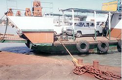
There is no bridge across the Hatania Doania creek at Namkhana. Four-wheelers are driven on to a ferry, which carries them across the creek.
Namkhana is linked to Sealdah by train, via Lakshmikantapur and Kakdwip.
South 24 Parganas district
South 24 Parganas district is an important district of West Bengal State with its district headquarters in Alipore. It has the urban fringe of Calcutta on one side and the remote riverine villages in the Sundarbans....
in the India
India
India , officially the Republic of India , is a country in South Asia. It is the seventh-largest country by geographical area, the second-most populous country with over 1.2 billion people, and the most populous democracy in the world...
n state
States and territories of India
India is a federal union of states comprising twenty-eight states and seven union territories. The states and territories are further subdivided into districts and so on.-List of states and territories:...
of West Bengal
West Bengal
West Bengal is a state in the eastern region of India and is the nation's fourth-most populous. It is also the seventh-most populous sub-national entity in the world, with over 91 million inhabitants. A major agricultural producer, West Bengal is the sixth-largest contributor to India's GDP...
. Kakdwip and Namkhana police stations serve this block. Headquarters of this block is at Namkhana.
Geography
Namkhana is located at 21.766667°N 88.233333°E.Namkhana community development block
Community Development Block in India
The Community development block is a rural area earmarked for administration and development in India. The area is administered by a Block Development Officer...
has an area of 227.14 km2.
Gram panchayats
Gram panchayatGram panchayat
Gram panchayats are local self-governments at the village or small town level in India. As of 2002 there were about 265,000 gram panchayats in India. The gram panchayat is the foundation of the Panchayat System. A gram panchayat can be set up in villages with minimum population of 300...
s of Namkhana block/panchayat samiti
Panchayat samiti
Panchayat samiti is a local government body at the tehsil or Taluka level in India. It works for the villages of the Tehsil or Taluka that together are called a Development Block. The Panchayat Samiti is the link between the Gram Panchayat and the district administration. There are a number of...
are: Budgakhali, Fraserganj, Haripur, Mousuni, Namkhana, Narayanpur and Shibrampur.
Demographics
As per 2001 census, Namkhana block had a total population of 160,630, out of which 82,234 were males and 78,396 were females. Namkhana block registered a population growth of 19,56 per cent during the 1991-2001 decade. Decadal growth for South 24 Parganas district was 20.89 per cent.Decadal growth in West Bengal was 17.84 per cent.Scheduled castes at 43,591 formed around one-fourth the population. Scheduled tribes numbered 1,466.
Literacy
As per 2001 census, Namkhana block had a total literacy of 78.40 per cent for the 6+ age group. While male literacy was 88.64 per cent female literacy was 67.63 per cent. South 24 Parganas district had a total literacy of 69.45 per cent, male literacy being 79.19 per cent and female literacy being 59.01 per cent.Transport
Bakkhali
Bakkhali is seaside resort in South 24 Parganas district of West Bengal, India. It is located on one of the many deltaic islands spread across southern Bengal. Most of the islands are part of the Sunderbans, barring a few at the fringes. Some of these are joined together with bridges over narrow...
which also happens to be a quaint little town by the sea like Digha
Digha
Digha is a seaside resort town in the state of West Bengal, India. It lies in East Midnapore district and at the northern end of the Bay of Bengal. It is the most popular sea resort in the West Bengal....
There is no bridge across the Hatania Doania creek at Namkhana. Four-wheelers are driven on to a ferry, which carries them across the creek.
Namkhana is linked to Sealdah by train, via Lakshmikantapur and Kakdwip.