

N59 road (Ireland)
Encyclopedia
The N59 road is a national secondary road
in Ireland
. It commences in County Sligo, south of Sligo
Town at the Belladrehid interchange with the N4 north of Ballysadare
. The route circles around the west of Ireland, passing west from Sligo into County Mayo
and through Ballina
. The N59 continues around Mayo, proceeding indirectly to Westport
. Continuing south through Mayo into County Galway
, the road passes through the village of Leenaun
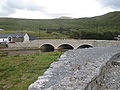
. The 182 year-old bridge in the centre of the village, carrying the road across the River Lahill, collapsed in floods on 18 July 2007. Due to the local terrain and road network, the diversionary route for getting from the south of the village to Westport was 110 km long. A temporary bridge was opened eight days after the floods, on 27 July. It has since been replaced by a new bridge.
 South of Leenaun, the N59 proceeds southwest through Connemara
to Clifden
. From there, it returns east through Maam Cross
and to Oughterard
, from which it proceeds southeast to Galway
city. The N59 ends at a junction with the N6 at Quincentenary Bridge. Top Gear Magazine has called this road one of "the world's greatest roads".
Source NRA
Ballina Orbital Route Project
The objective of the Ballina Orbital Route Project is to provide an orbital link around the town connecting all existing and future National Primary and National Secondary Roads, all existing Regional Roads and all existing Local Roads radiating from the town. The consequent benefit will be a reduction in traffic congestion due to traffic having the opportunity of avoiding the town centre. It will also serve to open up lands on the periphery of Ballina for future development.
Project webpage
Ballina to Crossmolina
This scheme will provide either an up-grade of the existing road or an off-line new route that will serve to bypass the town of Crossmolina on its western terminus, will link the towns of Crossmolina and Ballina and finally integrate with the preferred route for the Ballina Orbital Route on its eastern terminus. The project will be approximately 13 km long with at-grade junctions where necessary providing opportunities to interact with the existing road network.
Co. Galway
Moycullen Bypass Project
National secondary road
A national secondary road is a category of road in Ireland. These roads form an important part of the national route network, but are secondary to the main arterial routes which are classified as national primary roads. National secondary roads are designated with route numbers higher than those...
in Ireland
Republic of Ireland
Ireland , described as the Republic of Ireland , is a sovereign state in Europe occupying approximately five-sixths of the island of the same name. Its capital is Dublin. Ireland, which had a population of 4.58 million in 2011, is a constitutional republic governed as a parliamentary democracy,...
. It commences in County Sligo, south of Sligo
Sligo
Sligo is the county town of County Sligo in Ireland. The town is a borough and has a charter and a town mayor. It is sometimes referred to as a city, and sometimes as a town, and is the second largest urban area in Connacht...
Town at the Belladrehid interchange with the N4 north of Ballysadare
Ballysadare
Ballysadare is a village about 7 kilometres from Sligo town Centre. Built on the Ballysadare river, the area experienced rapid growth during the 'Celtic Tiger' boom, with many new housing developments, many of which now lie empty, creating phantom estates. The village was once choked with heavy...
. The route circles around the west of Ireland, passing west from Sligo into County Mayo
County Mayo
County Mayo is a county in Ireland. It is located in the West Region and is also part of the province of Connacht. It is named after the village of Mayo, which is now generally known as Mayo Abbey. Mayo County Council is the local authority for the county. The population of the county is 130,552...
and through Ballina
Ballina, County Mayo
Ballina is a large town in north County Mayo in Ireland. It lies at the mouth of the River Moy near Killala Bay, in the Moy valley and Parish of Kilmoremoy, with the Ox Mountain range to the east and the Nephin Beg mountains to the west...
. The N59 continues around Mayo, proceeding indirectly to Westport
Westport, County Mayo
Westport is a town in County Mayo, Ireland. It is situated on the west coast at the south-east corner of Clew Bay, an inlet of the Atlantic Ocean....
. Continuing south through Mayo into County Galway
County Galway
County Galway is a county in Ireland. It is located in the West Region and is also part of the province of Connacht. It is named after the city of Galway. Galway County Council is the local authority for the county. There are several strongly Irish-speaking areas in the west of the county...
, the road passes through the village of Leenaun
Leenaun
Leenaun , also Leenane, is a village and 1,845 acre townland in County Galway, Ireland. It is on the shore of Killary Harbour , on the northern edge of Connemara and is on the route of the Western Way long-distance trail...
. The 182 year-old bridge in the centre of the village, carrying the road across the River Lahill, collapsed in floods on 18 July 2007. Due to the local terrain and road network, the diversionary route for getting from the south of the village to Westport was 110 km long. A temporary bridge was opened eight days after the floods, on 27 July. It has since been replaced by a new bridge.
Connemara
Connemara is a district in the west of Ireland consisting of a broad peninsula between Killary Harbour and Kilkieran Bay in the west of County Galway.-Overview:...
to Clifden
Clifden
Clifden is a town on the coast of County Galway, Ireland and being Connemara's largest town, it is often referred to as "the Capital of Connemara". It is located on the Owenglen River where it flows into Clifden Bay...
. From there, it returns east through Maam Cross
Maam Cross
Maam Cross is a crossroads in Connemara, County Galway, Ireland. It lies within the townland of Shindilla.-Transport:*Maam Cross railway station opened on 1 January 1896 and finally closed on 29 April 1935.-See also:...
and to Oughterard
Oughterard
Oughterard is a small town on the banks of the Owenriff River close to the western shore of Lough Corrib in County Galway, Ireland. The population of the town in 2006 was 1,305...
, from which it proceeds southeast to Galway
Galway
Galway or City of Galway is a city in County Galway, Republic of Ireland. It is the sixth largest and the fastest-growing city in Ireland. It is also the third largest city within the Republic and the only city in the Province of Connacht. Located on the west coast of Ireland, it sits on the...
city. The N59 ends at a junction with the N6 at Quincentenary Bridge. Top Gear Magazine has called this road one of "the world's greatest roads".
Road Length (2006)
| Local Authority | Route Lengths By LA (km) | Total Route Lengths (km) |
|---|---|---|
| Sligo | 47.641 | |
| Mayo | 137.346 | |
| Galway | 109.399 | |
| Galway (City) | 2.669 | 297.055 |
Source NRA
Infrastructural Upgrades
Co. MayoBallina Orbital Route Project
The objective of the Ballina Orbital Route Project is to provide an orbital link around the town connecting all existing and future National Primary and National Secondary Roads, all existing Regional Roads and all existing Local Roads radiating from the town. The consequent benefit will be a reduction in traffic congestion due to traffic having the opportunity of avoiding the town centre. It will also serve to open up lands on the periphery of Ballina for future development.
Project webpage
Ballina to Crossmolina
This scheme will provide either an up-grade of the existing road or an off-line new route that will serve to bypass the town of Crossmolina on its western terminus, will link the towns of Crossmolina and Ballina and finally integrate with the preferred route for the Ballina Orbital Route on its eastern terminus. The project will be approximately 13 km long with at-grade junctions where necessary providing opportunities to interact with the existing road network.
Co. Galway
Moycullen Bypass Project
- Galway Route Selection and Preliminary Design Complete 2001, but as of May 2009 the project is in review with a view to canceling. It is no longer on NRA website as a programmed project.
See also
- Roads in IrelandRoads in IrelandThe island of Ireland, comprising Northern Ireland and the Republic of Ireland, has an extensive network of tens of thousands of kilometres of public roads, usually surfaced. These roads have been developed and modernised over centuries, from trackways suitable only for walkers and horses, to...
- Motorways in Ireland
- National primary roadNational primary roadA national primary road is a road classification in the Republic of Ireland. National primary roads form the major routes between the major urban centres. There are over 2,700km of national primary roads. This category of road has the prefix "N" followed by one or two digits...
- National secondary roadNational secondary roadA national secondary road is a category of road in Ireland. These roads form an important part of the national route network, but are secondary to the main arterial routes which are classified as national primary roads. National secondary roads are designated with route numbers higher than those...
- Regional roadRegional roadA regional road in Ireland is a class of road not forming a major route , but nevertheless forming a link in the national route network. There are over 11,600 kilometres of regional roads. Regional roads are numbered with three digit route numbers, prefixed by "R" A regional road in Ireland is a...