
Connemara
Encyclopedia


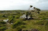
Ireland
Ireland is an island to the northwest of continental Europe. It is the third-largest island in Europe and the twentieth-largest island on Earth...
consisting of a broad peninsula between Killary Harbour
Killary Harbour
Killary Harbour/An Caoláire Rua is a fjord located in the West of Ireland in the heart of Connemara which forms a natural border between counties Galway and Mayo. It is 16 kilometres long and in the centre over 45 metres deep...
and Kilkieran
Kilkieran
Cill Chiaráin is a village in County Galway, Ireland. The R340 road along the coast from Galway city passes through Cill Chiaráin.Cill Chiaráin is a Gaeltacht area of Ireland...
Bay in the west of County Galway
County Galway
County Galway is a county in Ireland. It is located in the West Region and is also part of the province of Connacht. It is named after the city of Galway. Galway County Council is the local authority for the county. There are several strongly Irish-speaking areas in the west of the county...
.
Overview
The term Connemara is frequently used (although incorrectly) to describe all of County Galway west of Lough Corrib. It is also used to describe the GaeltachtGaeltacht
is the Irish language word meaning an Irish-speaking region. In Ireland, the Gaeltacht, or an Ghaeltacht, refers individually to any, or collectively to all, of the districts where the government recognises that the Irish language is the predominant language, that is, the vernacular spoken at home...
(Irish-speaking areas) of western County Galway; however, this is inaccurate as some of these areas are outside of the traditional boundary of Connemara. Another misconception is that Connemara's eastern boundary ends around Barna
Barna
Bearna is a Gaeltacht village west of Galway city in County Galway, Ireland, on the R336 regional road. Once a satellite of Galway city, the village is now rapidly becoming one of its suburbs. Officially the village is regarded as Irish speaking and is therefore a constituent part of the regions...
just on the outskirts of Galway City and Maam Cross
Maam Cross
Maam Cross is a crossroads in Connemara, County Galway, Ireland. It lies within the townland of Shindilla.-Transport:*Maam Cross railway station opened on 1 January 1896 and finally closed on 29 April 1935.-See also:...
.
Etymology
"Connemara" derives from the tribal name Conmacne Mara, which designated a branch of the Conmacne, an early tribal grouping that had a number of branches located in different parts of ConnachtConnacht
Connacht , formerly anglicised as Connaught, is one of the Provinces of Ireland situated in the west of Ireland. In Ancient Ireland, it was one of the fifths ruled by a "king of over-kings" . Following the Norman invasion of Ireland, the ancient kingdoms were shired into a number of counties for...
. Since this particular branch of the Conmacne lived by the sea, they became known as the Conmacne Mara. (Sea in Irish
Irish language
Irish , also known as Irish Gaelic, is a Goidelic language of the Indo-European language family, originating in Ireland and historically spoken by the Irish people. Irish is now spoken as a first language by a minority of Irish people, as well as being a second language of a larger proportion of...
is muir, genitive mara, hence "of the sea".) The area in the east of what is now Connemara was called Delbhna Tír Dhá Locha
Delbhna Tir Dha Locha
Dealbhne Thíre Dhá Loch was a tuath of Gaelic Ireland, located in the west of what is now Co. Galway, Ireland. It is now called Connemara-Overview:It was ruled by the Mac Conraoi clann...
.
Geography
Connemara lies in the territory of Iar ConnachtIar Connacht
Iar Chonnachta , was a region covering all of County Galway west of the river Corrib and Lough Corrib; Maigh Seola; and part of the barony of Ross in County Mayo.-Description:The area of Co...
, "West Connacht", which is the portion of County Galway west of Lough Corrib
Lough Corrib
Lough Corrib is a lake in the west of Ireland. The River Corrib or Galway river connects the lake to the sea at Galway. It is the second largest lough in Ireland . It covers 178 km² and lies mostly in County Galway with a small area of its northeast corner in County Mayo.The first canal in...
. Connemara was traditionally divided into North Connemara and South Connemara. The mountains of the Twelve Bens
Twelve Bens
The Twelve Bens, or Twelve Pins , is a mountain range of sharp-peaked quartzite ranges located northeast of Roundstone in Connemara in the west of Ireland. Dedicated fell runners attempt to hike all twelve peaks in a single day...
and the Owenglin River, which flows into the sea at An Clochán/Clifden
Clifden
Clifden is a town on the coast of County Galway, Ireland and being Connemara's largest town, it is often referred to as "the Capital of Connemara". It is located on the Owenglen River where it flows into Clifden Bay...
, marked the boundary between the two parts. Connemara is bounded on the west, south and north by the Atlantic Ocean
Atlantic Ocean
The Atlantic Ocean is the second-largest of the world's oceanic divisions. With a total area of about , it covers approximately 20% of the Earth's surface and about 26% of its water surface area...
. Connemara's land boundary with the rest of County Galway is marked by the Invermore River (which flows into the north of Kilkieran
Kilkieran
Cill Chiaráin is a village in County Galway, Ireland. The R340 road along the coast from Galway city passes through Cill Chiaráin.Cill Chiaráin is a Gaeltacht area of Ireland...
Bay), Loch Oorid, (which lies a few miles west of Maam Cross), and the western spine of the Maumturks
Maumturks
Na Sléibhte Mhám Toirc are a picturesque mountain range in Connemara in the west of Ireland. They are less well known than their more famous neighbours, the Twelve Bens on the other side of the Inagh Valley...
mountains. In the north of the mountains, the boundary meets the sea at Killary
Killary Harbour
Killary Harbour/An Caoláire Rua is a fjord located in the West of Ireland in the heart of Connemara which forms a natural border between counties Galway and Mayo. It is 16 kilometres long and in the centre over 45 metres deep...
, a few miles west of Leenaun
Leenaun
Leenaun , also Leenane, is a village and 1,845 acre townland in County Galway, Ireland. It is on the shore of Killary Harbour , on the northern edge of Connemara and is on the route of the Western Way long-distance trail...
.
Connemara is composed of the Catholic
Catholic
The word catholic comes from the Greek phrase , meaning "on the whole," "according to the whole" or "in general", and is a combination of the Greek words meaning "about" and meaning "whole"...
parishes of Carna, Clifden (Omey and Ballindoon), Ballynakill
Ballinakill, County Galway
Ballinakill is the name of a harbour near the town of Letterfrack in County Galway in Ireland.The harbour includes a number of islands such as Roeillaun . Fish in this harbour include salmon, pollock and mackerel. A trip on a glass bottomed boat allows visitors to view the wildlife and scenery...
, Roundstone
Roundstone
Roundstone may refer to:*Roundstone, County Galway, a village in the Republic of Ireland.*Roundstone, West Sussex, a village in England.*Roundstone Music, an English rock band....
and Inishbofin
Inishbofin, Galway
Inishbofin is an island lying about off the coast of Connemara, County Galway, Ireland. It is about 5.5 km long and wide, and has around 200 inhabitants. The island is popular with artists. Inishbofin can be reached by ferry from the pier in Cleggan...
. The territory contains the civil parishes of Moyrus, Ballynakill, Omey, Ballindoon and Inishbofin
Inishbofin
Inishbofin may refer to:* Inishbofin, County Galway, Ireland* Inishbofin, County Donegal, Ireland...
(the last parish was for a time part of the territory of the Clann Uí Mháille, the O Malleys of the territory of Umhall, County Mayo.)
History
The Ó CadhlaÓ Cadhla
Ó Cadhla is a masculine surname in the Irish language. The name translates into English as "descendant of Cadhla". The surname originated as a patronym, however it no longer refers to the actual name of the bearer's father. The form of the surname for unmarried females is Ní Chadhla. The forms for...
(Kealy) clan were the rulers of Connemara up until the 13th century, when they were displaced by the Ó Flaithbertaighs. The latter had fled into Iar Connacht
Iar Connacht
Iar Chonnachta , was a region covering all of County Galway west of the river Corrib and Lough Corrib; Maigh Seola; and part of the barony of Ross in County Mayo.-Description:The area of Co...
from Maigh Seola
Maigh Seola
Maigh Seola was a term used to describe the land along the east shore of Lough Corrib in County Galway, Ireland. It was bounded by the Uí Maine vassal kingdom of Soghain. Its rulers up to the 1220s were the Muintir Murchada, who took the surname O'Flaherty...
during the English invasion of Connacht in the early 13th century.
Like the Ó Cadhla clan, the Mac Conghaile (Conneely) clan was also a branch of the Conmhaicne Mara.
The coast of Connemara consists of a number of peninsulas. The peninsula of Iorras Ainbhtheach (sometimes corrupted to Iorras Aithneach) in the south is the largest and contains the villages of Carna and Kilkieran
Kilkieran
Cill Chiaráin is a village in County Galway, Ireland. The R340 road along the coast from Galway city passes through Cill Chiaráin.Cill Chiaráin is a Gaeltacht area of Ireland...
. The peninsula of Errismore consists of the area west of the village of Ballyconneely
Ballyconneely
Ballyconneely is a small ribbon development in west Connemara, County Galway, Ireland.Settlements are spread out north on the road to Clifden and south on the road to Roundstone...
. Errisbeg peninsula lies to the south of the village of Roundstone. The Errislannan peninsula lies just south of the town of Clifden
Clifden
Clifden is a town on the coast of County Galway, Ireland and being Connemara's largest town, it is often referred to as "the Capital of Connemara". It is located on the Owenglen River where it flows into Clifden Bay...
. The peninsulas of Kingstown, Aughris, Cleggan
Cleggan
Cleggan is a picturesque fishing village in County Galway, Ireland. The village lies 10 km northwest of Clifden and is situated at the head of Cleggan Bay....
and Renvyle are found in the north-west of Connemara. Of the numerous islands off the coast of Connemara, Inishbofin is the largest; other islands include Omey
Omey Island
Omey Island is a tidal island situated near Claddaghduff on the western edge of Connemara in County Galway, Ireland. From the mainland the island is inconspicuous and almost hidden. It is possible to drive or walk across a large sandy strand to the island by following the arrowed signs...
, Inishark, High Island, Friars Island, Feenish and Maínis
Maínis
Maínis is an island off the Conamara coast in the heart of the Conamara Gaeltacht. The island is close to Carna and linked to the mainland by a bridge. It is noted for its isolation and rugged beauty....
.
The main town of Connemara is Clifden. The area around the town is rich with megalithic tombs. The famous "Connemara Green marble" is found outcropping along a line between Streamstown and Lissoughter. It was a trade treasure used by the inhabitants of the prehistoric time. It continues to be of great value today. It is available in large dimensional slabs suitable for buildings as well as for smaller pieces of jewellery. It is used for the pendant for the Scouting Ireland Chief Scout's Award
Scouting Ireland Chief Scout's Award
The Chief Scout's Award is the highest award for Scouts in Scouting Ireland. The precise criteria for the Chief Scout's Award in Scouting Ireland as a result of the merger of CSI and SAI are unclear at present . It is the final step in the personal progressive scheme of the former CSI...
, the highest award in Irish Scouting
Scouting Ireland
Scouting Ireland is the World Organization of the Scout Movement-recognised Scouting association in the Republic of Ireland, although it also has Scout Groups in Northern Ireland. Scouting Ireland is a voluntary, non-formal educational movement for young people...
.
Notable towns and villages
- BallyconneelyBallyconneelyBallyconneely is a small ribbon development in west Connemara, County Galway, Ireland.Settlements are spread out north on the road to Clifden and south on the road to Roundstone...
- (Baile Conaola / Baile Mhic Chonghaile) - BallynahinchBallynahinchBallynahinch is the name of a number of towns in Ireland:*Ballynahinch, County Down, a town in Northern Ireland*Ballynahinch, County Armagh, a townland in County Armagh, Northern Ireland*Ballynahinch, County Galway in the Republic of Ireland...
- (Baile na hInse) - Carna - (Cárna)
- CarraroeCarraroeAn Cheathrú Rua is a village in County Galway, Ireland. The village is within the Irish-speaking region of Connemara, and is famous for its traditional fishing boats known as Galway Hookers. Its population is widely dispersed over Carraroe peninsula between Greatman's Bay and Casla Bay...
- (An Cheathrú Rua) - CladdaghduffCladdaghduffCladdaghduff is a village in County Galway, in the province of Connacht, Ireland. It is located northwest of Clifden, the gateway to Omey Island, and like much of Connemara is noted for its beautiful seascapes.-History:The village, now sparsely populated, offers much history...
- (An Cladach Dubh) - ClegganClegganCleggan is a picturesque fishing village in County Galway, Ireland. The village lies 10 km northwest of Clifden and is situated at the head of Cleggan Bay....
- (An Cloigeann) - ClifdenClifdenClifden is a town on the coast of County Galway, Ireland and being Connemara's largest town, it is often referred to as "the Capital of Connemara". It is located on the Owenglen River where it flows into Clifden Bay...
- (An Clochán) - InverinInverinIndreabhán is a Gaeltacht village between Spiddal and Casla in County Galway, Ireland. Inverin is more strongly Irish-speaking than Spiddal, partly due to fewer commuters from Galway living there. There are a number of Irish-language summer colleges in the area, most notably Coláiste Lurgan and...
- (Indreabhán) - KilkieranKilkieranCill Chiaráin is a village in County Galway, Ireland. The R340 road along the coast from Galway city passes through Cill Chiaráin.Cill Chiaráin is a Gaeltacht area of Ireland...
- (Cill Chiaráin) - LeenaunLeenaunLeenaun , also Leenane, is a village and 1,845 acre townland in County Galway, Ireland. It is on the shore of Killary Harbour , on the northern edge of Connemara and is on the route of the Western Way long-distance trail...
- (An Lionán / Leenane) - LetterfrackLetterfrackLetterfrack or Letterfrac is a small village in the Connemara area of County Galway, Ireland. It was founded by the Quakers in the mid-19th century. The village is 15 km north-east of Clifden on Barnaderg Bay and lies at the head of Ballinakill harbour...
- (Leitir Fraic) - LettermoreLettermoreLeitir Móir is a Gaeltacht village in County Galway, Ireland. It is also the name of an island, linked by road to the mainland, in which the village of Lettermore is situated. The name derives from the Irish Leitir Móir meaning great rough hillside . The main spoken language of the area is Irish...
- (Leitir Móir) - LettermullenLettermullenLettermullen is a small island on the west coast of Ireland in Connemara, County Galway situated approximately 36 miles from Galway city...
- (Leitir Mealláin) - MaumMaumAn Mám is a village in County Galway, Ireland. Its name is Irish for "the pass".-See also:* List of towns and villages in Ireland...
- (An Mám , also 'Maam') - RecessRecess, County GalwayRecess is a village in County Galway, Ireland. Its official name is in Irish, Sraith Saileach, and translates as "stream of the willow tree".-Transport:*Recess railway station opened on 1 July 1895 and was closed on 29 April 1935....
- (Sraith Salach) - Renvyle - (Rinn Mhaoile)
- RosmuckRosmuckRosmuc or Ros Muc is a village in the heart of the Conamara Gaeltacht of County Galway, Ireland. It lies halfway between the town of Clifden and the city of Galway. It is estimated that people first settled in Rosmuc in 400, one hundred years before Naomh Briocán brought Christianity to the area...
- (Ros Muc) - RoundstoneRoundstone, County GalwayRoundstone is a village in Connemara, County Galway, Ireland, located on the west coast of Ireland. The town of Clifden is nearby to the north....
- (Cloch na Rón)
Notable islands
- InishbofinInishbofin, GalwayInishbofin is an island lying about off the coast of Connemara, County Galway, Ireland. It is about 5.5 km long and wide, and has around 200 inhabitants. The island is popular with artists. Inishbofin can be reached by ferry from the pier in Cleggan...
- (Inis Bó Finne) - Omey IslandOmey IslandOmey Island is a tidal island situated near Claddaghduff on the western edge of Connemara in County Galway, Ireland. From the mainland the island is inconspicuous and almost hidden. It is possible to drive or walk across a large sandy strand to the island by following the arrowed signs...
- (Iomaidh)
Other uses
- French singer Michel SardouMichel SardouMichel Sardou is a French singer.He was born in Paris, the son of Fernand Sardou and Jackie Rollin . Contrary to claims common towards the beginning of his career, he is not the grandson of the dramatist Victorien Sardou...
had an international hit with the song "Les Lacs du Connemara" in 1981. - The Irish drinking song "The Hills of Connemara" has been recorded and performed by a number of Irish and Celtic-themed bands.
- Poet Carl SandburgCarl SandburgCarl Sandburg was an American writer and editor, best known for his poetry. He won three Pulitzer Prizes, two for his poetry and another for a biography of Abraham Lincoln. H. L. Mencken called Carl Sandburg "indubitably an American in every pulse-beat."-Biography:Sandburg was born in Galesburg,...
's home of 22 years in Flat Rock, North Carolina, which is now a national monumentCarl Sandburg Home National Historic SiteCarl Sandburg Home National Historic Site, located near Hendersonville in Flat Rock, North Carolina, preserves Connemara Farms, the home of Pulitzer Prize-winning poet and writer Carl Sandburg...
, is named after the Connemara region. - Conamara ChaosConamara ChaosConamara Chaos is a region of chaotic terrain on Jupiter's moon Europa. It is named after Connemara, in Ireland.Conamara Chaos is a landscape produced by the disruption of the icy crust of Europa. The region consists of rafts of ice that have moved around and rotated...
is a region of chaotic terrainChaos terrainChaos terrain is an astrogeological term used to denote planetary surface areas where features such as ridges, cracks, and plains appear jumbled and enmeshed with one another. Chaos terrain is a notable feature of the planet Mars and Jupiter's moon Europa...
on JupiterJupiterJupiter is the fifth planet from the Sun and the largest planet within the Solar System. It is a gas giant with mass one-thousandth that of the Sun but is two and a half times the mass of all the other planets in our Solar System combined. Jupiter is classified as a gas giant along with Saturn,...
's moon EuropaEuropa (moon)Europa Slightly smaller than Earth's Moon, Europa is primarily made of silicate rock and probably has an iron core. It has a tenuous atmosphere composed primarily of oxygen. Its surface is composed of ice and is one of the smoothest in the Solar System. This surface is striated by cracks and...
.
Notable people associated with Connemara
Indian prince and cricketing superstar Maharaja Jam Sahib of Nawanagar, the first head of state to make an official visit to the newly-founded Irish Free StateIrish Free State
The Irish Free State was the state established as a Dominion on 6 December 1922 under the Anglo-Irish Treaty, signed by the British government and Irish representatives exactly twelve months beforehand...
, bought Ballynahinch Castle estate and visited the area every year till his death in 1932.
Austrian philosopher Ludwig Wittgenstein
Ludwig Wittgenstein
Ludwig Josef Johann Wittgenstein was an Austrian philosopher who worked primarily in logic, the philosophy of mathematics, the philosophy of mind, and the philosophy of language. He was professor in philosophy at the University of Cambridge from 1939 until 1947...
was a temporary resident, for some months in 1948, at Rosroe on Killary Harbour
Killary Harbour
Killary Harbour/An Caoláire Rua is a fjord located in the West of Ireland in the heart of Connemara which forms a natural border between counties Galway and Mayo. It is 16 kilometres long and in the centre over 45 metres deep...
.
Cartographer Tim Robinson has lived many years in Connemara and published books on the area.
See also
- Alcock and BrownAlcock and BrownBritish aviators Alcock and Brown made the first non-stop transatlantic flight in June 1919. They flew a modified World War I Vickers Vimy bomber from St. John's, Newfoundland, to Clifden, Connemara, County Galway, Ireland...
's first non-stop flight across the Atlantic crash landed near Clifden - Aran IslandsAran IslandsThe Aran Islands or The Arans are a group of three islands located at the mouth of Galway Bay, on the west coast of Ireland. They constitute the barony of Aran in County Galway, Ireland...
(day trips from RossavealRossavealRos an Mhíl or Ros a' Mhíl is a Gaeltacht village in the Connemara area of County Galway, Ireland. It is the main ferry port for the Aran Islands in Galway Bay...
) - Connacht IrishConnacht IrishConnacht Irish is the dialect of the Irish language spoken in the province of Connacht. Gaeltacht regions in Connacht are found in Counties Mayo and Galway...
- Connemara Heritage & History CentreConnemara Heritage & History CentreThe Connemara Heritage and History Centre is an open air museum in the village of Lettershea, near the town of Clifden, County Galway, in the Connemara region of western Ireland...
- Connemara National ParkConnemara National ParkConnemara National Park is one of six National Parks in the Republic of Ireland that are managed by the National Parks and Wildlife Service of the Department of the Environment, Heritage and Local Government. It is located in the west of Ireland within County Galway.-History:Connemara National...
- Lough CorribLough CorribLough Corrib is a lake in the west of Ireland. The River Corrib or Galway river connects the lake to the sea at Galway. It is the second largest lough in Ireland . It covers 178 km² and lies mostly in County Galway with a small area of its northeast corner in County Mayo.The first canal in...
- The Twelve Pins and MaumturksMaumturksNa Sléibhte Mhám Toirc are a picturesque mountain range in Connemara in the west of Ireland. They are less well known than their more famous neighbours, the Twelve Bens on the other side of the Inagh Valley...
mountains - The Western WayWestern WayThe Western Way is a long-distance trail in Ireland. It is long and begins in Oughterard, County Galway and ends in Ballycastle, County Mayo. It is typically completed in seven days...
(Long-distance trailLong-distance trailLong-distance trails are the longer recreational trails mainly through rural areas, used for non-motorised recreational travelling ....
) - The Connemara PonyConnemara ponyThe Connemara pony is a pony breed originating in Ireland. They are known for their athleticism, versatility and good disposition. The breed makes excellent show ponies.-History:...