
Musbury
Encyclopedia
Musbury is a village and civil parish in the East Devon
district of Devon
, England
. It lies approximately 2 miles away from Colyton
and 2.5 miles away from Axminster
, the nearest towns. Musbury is served by the A358 road and lies on the route of the East Devon Way
, a 40-mile footpath following the Axe Valley. The village is within the East Devon Area of Natural Beauty
. It has a post office, primary school, fuel station and church.
hill fort
of Musbury Castle
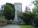
on the hill above it, from which there are excellent views of the Axe Valley. The parish church, which is dedicated to St. Michael, is a 15th century structure that was much rebuilt and restored
by the Victorians. It contains the Drake Memorial dating from 1611.
John Churchill, who became the Duke of Marlborough is thought to have been born about 1 mile north of the village at Trill, his parents having lived at Ashe House also to the north of the village.
East Devon
East Devon is a local government district in Devon, England. Its council is based in Sidmouth, and the largest town is Exmouth.The district was formed on 1 April 1974 by the merger of the borough of Honiton with the urban districts of Budleigh Salterton, Exmouth, Ottery St. Mary, Seaton, Sidmouth...
district of Devon
Devon
Devon is a large county in southwestern England. The county is sometimes referred to as Devonshire, although the term is rarely used inside the county itself as the county has never been officially "shired", it often indicates a traditional or historical context.The county shares borders with...
, England
England
England is a country that is part of the United Kingdom. It shares land borders with Scotland to the north and Wales to the west; the Irish Sea is to the north west, the Celtic Sea to the south west, with the North Sea to the east and the English Channel to the south separating it from continental...
. It lies approximately 2 miles away from Colyton
Colyton, Devon
Colyton is a small town in Devon, England. It is located within the East Devon local authority area. It is 3 miles away from Seaton and 6 miles away from Axminster. Its population in 1991 was 2,783.-History:...
and 2.5 miles away from Axminster
Axminster
Axminster is a market town and civil parish on the eastern border of Devon in England. The town is built on a hill overlooking the River Axe which heads towards the English Channel at Axmouth, and is in the East Devon local government district. It has a population of 5,626. The market is still...
, the nearest towns. Musbury is served by the A358 road and lies on the route of the East Devon Way
East Devon Way
The East Devon Way is a long distance footpath in England. It runs for 38 miles between Exmouth in East Devon and Lyme Regis in Dorset.Landscapes seen on the path include; estuary, high open commons, woodlands and river valleys. The route includes some fairly steep climbs but is generally not...
, a 40-mile footpath following the Axe Valley. The village is within the East Devon Area of Natural Beauty
East Devon AONB
East Devon Area of Outstanding Natural Beauty covers over of the East Devon countryside .This countryside includes eighteen miles of Heritage coastline...
. It has a post office, primary school, fuel station and church.
History
The village takes its name from the Iron AgeIron Age
The Iron Age is the archaeological period generally occurring after the Bronze Age, marked by the prevalent use of iron. The early period of the age is characterized by the widespread use of iron or steel. The adoption of such material coincided with other changes in society, including differing...
hill fort
Hill fort
A hill fort is a type of earthworks used as a fortified refuge or defended settlement, located to exploit a rise in elevation for defensive advantage. They are typically European and of the Bronze and Iron Ages. Some were used in the post-Roman period...
of Musbury Castle
Musbury Castle
Musbury Castle is an Iron Age Hill fort situated above the Village of Musbury in Devon. The fort occupies a commanding hill top approx 175 Metres above Sea Level overlooking the Axe valleyat Ordnance Survey ....
on the hill above it, from which there are excellent views of the Axe Valley. The parish church, which is dedicated to St. Michael, is a 15th century structure that was much rebuilt and restored
Victorian restoration
Victorian restoration is the term commonly used to refer to the widespread and extensive refurbishment and rebuilding of Church of England churches and cathedrals that took place in England and Wales during the 19th-century reign of Queen Victoria...
by the Victorians. It contains the Drake Memorial dating from 1611.
John Churchill, who became the Duke of Marlborough is thought to have been born about 1 mile north of the village at Trill, his parents having lived at Ashe House also to the north of the village.