
Murujuga
Encyclopedia
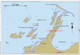
Murujuga is a peninsula
(20.581°S 116.808°E) often known as Burrup Peninsula in the Pilbara region
of Western Australia
, adjoining the Dampier Archipelago
and near the town of Dampier
. (The Dampier Archipelago is not to be confused with the Dampier Peninsula
, 800 km to the north-east.)
The peninsula is a unique ecological and archaeological area since it contains the world's largest and most important collection of petroglyph
s – ancient Aboriginal rock carvings some claim to date back as far as the last ice age
about 10,000 years ago. The collection of standing stones here is the largest in Australia with rock art petroglyphs numbering over one million, many depicting images of the now extinct Thylacine
("Tasmanian Tiger").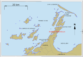 The Dampier Rock Art Precinct, which covers the entire Archipelago, is currently the subject of much debate due to a large supply of off-shore natural gas
in the area being sourced by Woodside Petroleum
.
commenced a campaign to preserve the remaining monument. Murujuga has been listed in the National Trust of Australia
Endangered Places Register and in the 2004, 2006, and 2008 World Monuments Watch by the World Monuments Fund
. No other sites in Australia have ever appeared in the World Monuments Watch.
Claims have been made that since 1963, 24.4 percent of the rock art on Murujuga has been destroyed to make way for industrial development. However, the Western Australian government, responding to a question in parliament, has argued for a much lower figure, suggesting that approximately 4 percent of sites, representing approximately 7.2 percent of petroglyphs, have been destroyed since 1972. However, as the Western Australian government has noted, there is no complete inventory of rock art in the region, making assessments of current and future impacts on the site a challenging task.
In 1996, a Burrup Peninsula Land Use Plan and Management Strategy, prepared by the Burrup Peninsula Management Advisory Board, presented an approach to multiple land use on the Burrup Peninsula. The primary purpose of the Burrup Peninsula Land Use Plan and Management Strategy was to allocate land for industry, conservation, heritage and recreation following on from an earlier multiple land use plan for the Burrup Peninsula The Pilbara 21, Final Strategy Report (1992). The 1996 Plan attempted to balance competing land uses through the division of the Burrup Peninsula into two broad land use areas: (a) Conservation, Heritage and Recreation Area; and (b) an Industrial Area. The Plan recommend allocating approximately 5,400 hectares (62%) of the Peninsula for conservation, heritage and recreation, and associated uses – leaving (it is assumed) 38% of the area for “the allocation of industrial land (in addition to existing industrial leases) with an emphasis on port sites and strategic industry”. While comment is provided in the plan on “the value of the Northern Burrup for preservation of its renowned Aboriginal heritage and environmental values” no comment is made on the amount of rock art affected by development and recreational activities.
Work commissioned by the West Australian National Trust led it to nominate the site for the National Trust Endangered Places list in 2002. In 2004, funding was provided by American Express
through the World Monuments Fund
for further research and advocacy to be undertaken, with the goal of achieving national heritage status for the site. In 2006 the Australian Heritage Council
advised the federal Environment and Heritage Minister that the site was suitable for National Heritage listing.
The West Australian State government
has continued to support development at the site, arguing a lack of cost-effective alternative sites and that geographical expansion of facility areas will be extremely limited. The campaign against development has blurred some traditional political boundaries, with former conservative party Resources Development Minister Mr Colin Barnett
now supporting campaigns to save rock art in this area.
The debate has placed the Australian national government in a difficult situation. On the one hand, national heritage bodies have supported protection for the area, and the governments at national and state level have been of opposing political parties, giving the federal government reason to support site protection. On the other hand, the Western Australian economy has been crucial to Australia's economic wealth generally, and its export earnings in particular, and the national government will be reluctant to appear to interfere with that economic prosperity.
The protest campaign against development has garnered popular support:
By June 2007, the debate continues, with the Australian government still to determine what if any intervention it may make in the case under federal heritage protection or other laws. The federal minister indicated support for National Heritage listing, however the question of site boundaries and management strategies was still under negotiation.
The site was heritage listed in 2007.
On 7 July 2008, the Australian Government placed 90% of the remaining rock art areas of the Dampier Archipelago on the National Heritage List. Campaigners are now demanding that the Australian Government includue all of the undisturbed areas of the Dampier Arciapelago on the World Heritage List.
The area remains on the World Monument Fund's list of 100 Most Endangered Places in the World - the only such site in Australia - because of continued mismanagement of the heritage and conservation values of the Burrup.
Peninsula
A peninsula is a piece of land that is bordered by water on three sides but connected to mainland. In many Germanic and Celtic languages and also in Baltic, Slavic and Hungarian, peninsulas are called "half-islands"....
(20.581°S 116.808°E) often known as Burrup Peninsula in the Pilbara region
Pilbara region of Western Australia
The Pilbara is a large, dry, thinly populated region in the north of Western Australia known for its vast mineral deposits, in particular iron ore...
of Western Australia
Western Australia
Western Australia is a state of Australia, occupying the entire western third of the Australian continent. It is bounded by the Indian Ocean to the north and west, the Great Australian Bight and Indian Ocean to the south, the Northern Territory to the north-east and South Australia to the south-east...
, adjoining the Dampier Archipelago
Dampier Archipelago
The Dampier Archipelago is a group of islands near Dampier, Western Australia. It is named after William Dampier, an English buccaneer and explorer who visited in 1699. Dampier named one of the islands, Rosemary Island.-History:...
and near the town of Dampier
Dampier, Western Australia
Dampier is a major industrial port in the north-west of Western Australia. The Dampier Port is part of the Dampier Archipelago. The port services petrochemical, salt, iron ore and natural gas export industries. Rio Tinto exports large volumes of iron ore through the port, and in September 2010...
. (The Dampier Archipelago is not to be confused with the Dampier Peninsula
Dampier Peninsula
The Dampier Peninsula is a peninsula located north of Broome and Roebuck Bay in Western Australia. It is surrounded by the Indian Ocean to the west and north, and King Sound to the east...
, 800 km to the north-east.)
The peninsula is a unique ecological and archaeological area since it contains the world's largest and most important collection of petroglyph
Petroglyph
Petroglyphs are pictogram and logogram images created by removing part of a rock surface by incising, picking, carving, and abrading. Outside North America, scholars often use terms such as "carving", "engraving", or other descriptions of the technique to refer to such images...
s – ancient Aboriginal rock carvings some claim to date back as far as the last ice age
Ice age
An ice age or, more precisely, glacial age, is a generic geological period of long-term reduction in the temperature of the Earth's surface and atmosphere, resulting in the presence or expansion of continental ice sheets, polar ice sheets and alpine glaciers...
about 10,000 years ago. The collection of standing stones here is the largest in Australia with rock art petroglyphs numbering over one million, many depicting images of the now extinct Thylacine
Thylacine
The thylacine or ,also ;binomial name: Thylacinus cynocephalus, Greek for "dog-headed pouched one") was the largest known carnivorous marsupial of modern times. It is commonly known as the Tasmanian tiger or the Tasmanian wolf...
("Tasmanian Tiger").
Natural gas
Natural gas is a naturally occurring gas mixture consisting primarily of methane, typically with 0–20% higher hydrocarbons . It is found associated with other hydrocarbon fuel, in coal beds, as methane clathrates, and is an important fuel source and a major feedstock for fertilizers.Most natural...
in the area being sourced by Woodside Petroleum
Woodside Petroleum
Woodside Petroleum Limited is an Australian petroleum exploration and production company. It is a public company listed on the Australian Securities Exchange and has its headquarters in Perth, Western Australia.-History:...
.
Development controversy
Concern around the ecological, historical, cultural and archaeological significance of the area has led to a campaign for its protection, causing conflict with industrial development on the site. The preservation of the Murujuga monument has been called for since 1969, and in 2002 the International Federation of Rock Art Organizations (IFRAO)International Federation of Rock Art Organizations (IFRAO)
The International Federation of Rock Art Organizations is a coordinating body of 44 organizations concerned with prehistoric rock art.-History:...
commenced a campaign to preserve the remaining monument. Murujuga has been listed in the National Trust of Australia
National Trust of Australia
The Australian Council of National Trusts is the peak body for community-based, non-government organisations committed to promoting and conserving Australia's indigenous, natural and historic heritage....
Endangered Places Register and in the 2004, 2006, and 2008 World Monuments Watch by the World Monuments Fund
World Monuments Fund
World Monuments Fund is a private, international, non-profit organization dedicated to the preservation of historic architecture and cultural heritage sites around the world through fieldwork, advocacy, grantmaking, education, and training....
. No other sites in Australia have ever appeared in the World Monuments Watch.
Claims have been made that since 1963, 24.4 percent of the rock art on Murujuga has been destroyed to make way for industrial development. However, the Western Australian government, responding to a question in parliament, has argued for a much lower figure, suggesting that approximately 4 percent of sites, representing approximately 7.2 percent of petroglyphs, have been destroyed since 1972. However, as the Western Australian government has noted, there is no complete inventory of rock art in the region, making assessments of current and future impacts on the site a challenging task.
In 1996, a Burrup Peninsula Land Use Plan and Management Strategy, prepared by the Burrup Peninsula Management Advisory Board, presented an approach to multiple land use on the Burrup Peninsula. The primary purpose of the Burrup Peninsula Land Use Plan and Management Strategy was to allocate land for industry, conservation, heritage and recreation following on from an earlier multiple land use plan for the Burrup Peninsula The Pilbara 21, Final Strategy Report (1992). The 1996 Plan attempted to balance competing land uses through the division of the Burrup Peninsula into two broad land use areas: (a) Conservation, Heritage and Recreation Area; and (b) an Industrial Area. The Plan recommend allocating approximately 5,400 hectares (62%) of the Peninsula for conservation, heritage and recreation, and associated uses – leaving (it is assumed) 38% of the area for “the allocation of industrial land (in addition to existing industrial leases) with an emphasis on port sites and strategic industry”. While comment is provided in the plan on “the value of the Northern Burrup for preservation of its renowned Aboriginal heritage and environmental values” no comment is made on the amount of rock art affected by development and recreational activities.
Work commissioned by the West Australian National Trust led it to nominate the site for the National Trust Endangered Places list in 2002. In 2004, funding was provided by American Express
American Express
American Express Company or AmEx, is an American multinational financial services corporation headquartered in Three World Financial Center, Manhattan, New York City, New York, United States. Founded in 1850, it is one of the 30 components of the Dow Jones Industrial Average. The company is best...
through the World Monuments Fund
World Monuments Fund
World Monuments Fund is a private, international, non-profit organization dedicated to the preservation of historic architecture and cultural heritage sites around the world through fieldwork, advocacy, grantmaking, education, and training....
for further research and advocacy to be undertaken, with the goal of achieving national heritage status for the site. In 2006 the Australian Heritage Council
Australian Heritage Council
Australian Heritage Council was established on 19 February, 2004 as the Australian body responsible for advising the Australian Government on cultural heritage matters...
advised the federal Environment and Heritage Minister that the site was suitable for National Heritage listing.
The West Australian State government
Government of Western Australia
The formation of the Government of Western Australia is prescribed in its Constitution, which dates from 1890, although it has been amended many times since then...
has continued to support development at the site, arguing a lack of cost-effective alternative sites and that geographical expansion of facility areas will be extremely limited. The campaign against development has blurred some traditional political boundaries, with former conservative party Resources Development Minister Mr Colin Barnett
Colin Barnett
Colin James Barnett , Australian politician, is the leader of the Western Australian Liberal Party, the 29th and current Premier of Western Australia since the 2008 election and served as the Treasurer of Western Australia in 2010. He was sworn into office by Governor Ken Michael on 23 September 2008...
now supporting campaigns to save rock art in this area.
The debate has placed the Australian national government in a difficult situation. On the one hand, national heritage bodies have supported protection for the area, and the governments at national and state level have been of opposing political parties, giving the federal government reason to support site protection. On the other hand, the Western Australian economy has been crucial to Australia's economic wealth generally, and its export earnings in particular, and the national government will be reluctant to appear to interfere with that economic prosperity.
The protest campaign against development has garnered popular support:
42,000 personal messages were lodged with Woodside's Directors at their Annual General Meeting. Following shareholders questions at the AGM, Director Don Voelte finally admitted that the State Government had directed them towards developing amidst the rock art and that they had accepted.
By June 2007, the debate continues, with the Australian government still to determine what if any intervention it may make in the case under federal heritage protection or other laws. The federal minister indicated support for National Heritage listing, however the question of site boundaries and management strategies was still under negotiation.
The site was heritage listed in 2007.
On 7 July 2008, the Australian Government placed 90% of the remaining rock art areas of the Dampier Archipelago on the National Heritage List. Campaigners are now demanding that the Australian Government includue all of the undisturbed areas of the Dampier Arciapelago on the World Heritage List.
The area remains on the World Monument Fund's list of 100 Most Endangered Places in the World - the only such site in Australia - because of continued mismanagement of the heritage and conservation values of the Burrup.
External links
- ABC Online Greens push for Burrup rock art heritage listing
- ABC Online Pilbara Rock Art not Affected by Mining Emissions: Study
- Save Dampier Rock Art home-page
- National Trust information on Dampier Rock Art
- IFRAO
- Department of Industry and Resources (WA)
- Friends of Australian Rock Art campaign website
- The World Monuments Fund's Watch Listing for the Dampier Rock Art
Further reading
- Vinnicombe, P. (2002), Petroglyphs of the Dampier Archipelago: Background to Development and Descriptive Analysis, Rock Art Research, Volume 19, No 1, pp 3–27