

Murton, York
Encyclopedia
Murton is a small village and a civil parish
in the unitary authority
of the City of York in North Yorkshire
, England
that is located on the outskirts of York
. To the west there is the A64
and the village of Osbaldwick
, to the south the A166 road to Bridlington
, to the north the village of Stockton-on-the-Forest
, and to the east the villages of Holtby
and Warthill
.
According to the 2001 census the parish had a population of 423. Prior to 1996 it had been part of the Ryedale
district.
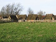
The village has around a hundred properties ranging from traditional large country houses to more modern buildings.
 The village is home to the Yorkshire Museum of Farming
at Murton Park. Here there is a small railway track which is the remains of the Derwent Valley Light Railway
. Trains are run on Sundays and bank holidays. The village has a local pub called the Bay Horse. The York Livestock Centre is also located in Murton.
The village has a small church named after St James, which is linked with St Thomas' Church in Osbaldwick.
Civil parish
In England, a civil parish is a territorial designation and, where they are found, the lowest tier of local government below districts and counties...
in the unitary authority
Unitary authority
A unitary authority is a type of local authority that has a single tier and is responsible for all local government functions within its area or performs additional functions which elsewhere in the relevant country are usually performed by national government or a higher level of sub-national...
of the City of York in North Yorkshire
North Yorkshire
North Yorkshire is a non-metropolitan or shire county located in the Yorkshire and the Humber region of England, and a ceremonial county primarily in that region but partly in North East England. Created in 1974 by the Local Government Act 1972 it covers an area of , making it the largest...
, England
England
England is a country that is part of the United Kingdom. It shares land borders with Scotland to the north and Wales to the west; the Irish Sea is to the north west, the Celtic Sea to the south west, with the North Sea to the east and the English Channel to the south separating it from continental...
that is located on the outskirts of York
York
York is a walled city, situated at the confluence of the Rivers Ouse and Foss in North Yorkshire, England. The city has a rich heritage and has provided the backdrop to major political events throughout much of its two millennia of existence...
. To the west there is the A64
A64 road
The A64 is a road in North and West Yorkshire, England which links Leeds, York and Scarborough. The A64 starts as the A64 ring road motorway in Leeds and then is a dual carriageway for the rest of its route, except parts of the road from Malton to Scarborough.The road approximates a section of the...
and the village of Osbaldwick
Osbaldwick
Osbaldwick is a village and civil parish in the unitary authority of the City of York in North Yorkshire, England. It has been in existence since at least the 11th century, and is now a conservation area. It is the burial place of the nun Mary Ward....
, to the south the A166 road to Bridlington
Bridlington
Bridlington is a seaside resort, minor sea fishing port and civil parish on the Holderness Coast of the North Sea, in the East Riding of Yorkshire, England. It has a static population of over 33,000, which rises considerably during the tourist season...
, to the north the village of Stockton-on-the-Forest
Stockton-on-the-Forest
Stockton-on-the-Forest is a village and civil parish in the unitary authority of the City of York in North Yorkshire, England. It is located to the east of the A64 road to Scarborough and the roundabout interchange of the A64 and the A1036...
, and to the east the villages of Holtby
Holtby
Holtby is a small village and civil parish in the unitary authority of the City of York in North Yorkshire, England. It lies on the A166 about east of York....
and Warthill
Warthill
Warthill is a village and civil parish in the Ryedale district of North Yorkshire, England, about six miles east of York. The village is part of Ryedale District Council....
.
According to the 2001 census the parish had a population of 423. Prior to 1996 it had been part of the Ryedale
Ryedale
Ryedale is a non-metropolitan district of the shire county of North Yorkshire in England. Settlements include Helmsley, Kirkbymoorside, Malton, Norton-on-Derwent, Pickering, and Terrington.-Derivation of name:...
district.
The village has around a hundred properties ranging from traditional large country houses to more modern buildings.
Yorkshire Museum of Farming
The Yorkshire Museum of Farming is located in Murton Park near York in England. It is housed on a grass field site of approximately , and is the only museum in the district specifically dedicated to the subject of farming. In the autumn of 2010, the museum was awarded full accreditation status by...
at Murton Park. Here there is a small railway track which is the remains of the Derwent Valley Light Railway
Derwent Valley Light Railway
The Derwent Valley Light Railway was a privately-owned standard-gauge railway running from Layerthorpe on the outskirts of York to Cliffe Common near Selby in North Yorkshire, England. It opened in 1913, and closed in sections between 1965 and 1981...
. Trains are run on Sundays and bank holidays. The village has a local pub called the Bay Horse. The York Livestock Centre is also located in Murton.
The village has a small church named after St James, which is linked with St Thomas' Church in Osbaldwick.