
Stockton-on-the-Forest
Encyclopedia
Stockton-on-the-Forest is a village and civil parish
in the unitary authority
of the City of York in North Yorkshire
, England
. It is located to the east of the A64 road
to Scarborough and the roundabout interchange
of the A64 and the A1036. To the east there are the villages of Upper Helmsley and Sand Hutton
and to the south the villages of Warthill
, Holtby
and Murton
.
 According to the 2001 census the parish had a population of 1,261. Prior to 1996, it had been part of the Ryedale
district.
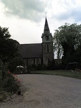
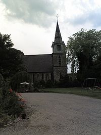
The village is home to Stockton Hall a secure unit for mentally ill patients. The village has a busy local pub, called The Fox. The village has one church, the Holy Trinity Church (rebuilt in 1843). The Methodist Chapel was closed in May 2010. Stockton on the Forest also has a primary school for local residents accommodating approximately 100 pupils.
Stockton on the Forest is a good example of a linear village
, as it follows only one main road (Stockon Lane/Sandy Lane) for approximately 1.5 miles (2.4 km), branching out only near the west end. The houses along the main road do not have house numbers but individual names (many with references to agriculture, local features or mysticism) of no particular order or logic, which can make orientation difficult, if not impossible, for people unfamiliar with the village.
Civil parish
In England, a civil parish is a territorial designation and, where they are found, the lowest tier of local government below districts and counties...
in the unitary authority
Unitary authority
A unitary authority is a type of local authority that has a single tier and is responsible for all local government functions within its area or performs additional functions which elsewhere in the relevant country are usually performed by national government or a higher level of sub-national...
of the City of York in North Yorkshire
North Yorkshire
North Yorkshire is a non-metropolitan or shire county located in the Yorkshire and the Humber region of England, and a ceremonial county primarily in that region but partly in North East England. Created in 1974 by the Local Government Act 1972 it covers an area of , making it the largest...
, England
England
England is a country that is part of the United Kingdom. It shares land borders with Scotland to the north and Wales to the west; the Irish Sea is to the north west, the Celtic Sea to the south west, with the North Sea to the east and the English Channel to the south separating it from continental...
. It is located to the east of the A64 road
A64 road
The A64 is a road in North and West Yorkshire, England which links Leeds, York and Scarborough. The A64 starts as the A64 ring road motorway in Leeds and then is a dual carriageway for the rest of its route, except parts of the road from Malton to Scarborough.The road approximates a section of the...
to Scarborough and the roundabout interchange
Roundabout interchange
A roundabout interchange is a type of interchange between a controlled access highway such as a motorway or freeway, and a minor road, in which the slip roads to and from the motorway carriageways converge at a single roundabout, which is grade-separated from the motorway lanes with bridges...
of the A64 and the A1036. To the east there are the villages of Upper Helmsley and Sand Hutton
Sand Hutton
Sand Hutton is a village and civil parish in the Ryedale district of North Yorkshire, England, about north-east of York.Part of the Department for Environment, Food and Rural Affairs's Food and Environment Research Agency is sited at Sand Hutton....
and to the south the villages of Warthill
Warthill
Warthill is a village and civil parish in the Ryedale district of North Yorkshire, England, about six miles east of York. The village is part of Ryedale District Council....
, Holtby
Holtby
Holtby is a small village and civil parish in the unitary authority of the City of York in North Yorkshire, England. It lies on the A166 about east of York....
and Murton
Murton, York
Murton is a small village and a civil parish in the unitary authority of the City of York in North Yorkshire, England that is located on the outskirts of York...
.
Ryedale
Ryedale is a non-metropolitan district of the shire county of North Yorkshire in England. Settlements include Helmsley, Kirkbymoorside, Malton, Norton-on-Derwent, Pickering, and Terrington.-Derivation of name:...
district.
The village is home to Stockton Hall a secure unit for mentally ill patients. The village has a busy local pub, called The Fox. The village has one church, the Holy Trinity Church (rebuilt in 1843). The Methodist Chapel was closed in May 2010. Stockton on the Forest also has a primary school for local residents accommodating approximately 100 pupils.
Stockton on the Forest is a good example of a linear village
Linear village
In geography, a linear village, or linear settlement, is a small to medium-sized settlement that is formed around a transport route, such as a road, river, or canal. Wraysbury, a village in Berkshire, is one of the longest villages in England....
, as it follows only one main road (Stockon Lane/Sandy Lane) for approximately 1.5 miles (2.4 km), branching out only near the west end. The houses along the main road do not have house numbers but individual names (many with references to agriculture, local features or mysticism) of no particular order or logic, which can make orientation difficult, if not impossible, for people unfamiliar with the village.