
Mount Taylor
Encyclopedia
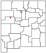
Mount Taylor is a stratovolcano
in northwest New Mexico
, northeast of the town of Grants
. It is the high point of the San Mateo Mountains
There are two small ranges in New Mexico called the San Mateo Mountains; this is the northern one. The other range
is near the Plains of San Agustin. and the highest point in the Cibola National Forest
. It was named in 1849 for then president
Zachary Taylor
. Prior to that, it was called Cebolleta (tender onion) by the Spanish; the name persists as one name for the northern portion of the San Mateo Mountains, a large mesa
. Mount Taylor is largely forested, rising like a blue cone above the desert below. Its slopes were an important source of lumber for neighboring pueblo
s.
, Mount Taylor is , the turquoise mountain, one of the four sacred mountains marking the cardinal directions and the boundaries of the Dinetah
, the traditional Navajo homeland. Mount Taylor marks the southern boundary, and is associated with the direction south and the color blue; it is gendered female. In Navajo mythology, First Man created the sacred mountains from soil from the Fourth World, together with sacred matter, as replicas of mountains from that world. He fastened Mount Taylor to the earth with a stone knife. The supernatural beings Black God, Turquoise Boy, and Turquoise Girl are said to reside on the mountain.
Mount Taylor is also sacred to the Acoma
, Laguna
and Zuni people.
during the Pliocene
, and is surrounded by a field of smaller inactive volcanoes. Repeated eruptions built lava dome
s and produced lava
flows, ash plumes, and mudflow
s. The mountain is surrounded by a great volume of volcanic debris, suggesting multiple major eruptions, possibly similar to that of Mount Saint Helens and the San Francisco Peaks
near Flagstaff, Arizona
.
Estimates vary about how high the mountain was at its highest. Conservative estimates place its maximum near a similar pre-explosion height for the San Francisco Peaks
of 16000 foot, and an extreme estimate places it near 25000 feet (7,620 m).
-vanadium
bearing mineral, and was mined extensively for it from 1979 to 1990. The Mount Taylor and the hundreds of other uranium mines on Pueblo lands have provided over thirteen million tons of uranium ore to the United States since 1945.
Concern has arisen regarding the impact of future mining activities on the site. In June 2008 the New Mexico Cultural Properties Review Committee voted in favor of a one year emergency listing of more than 422000 acres (170,777.5 ha) surrounding the mountain’s summit on the state Register of Cultural Properties. "The Navajo Nation, the Acoma, Laguna and Zuni pueblos, and the Hopi tribe of Arizona asked the state to approve the listing for a mountain they consider sacred to protect it from an anticipated uranium mining boom, according to the nomination report."
In April 2009, Mount Taylor was added to the National Trust for Historic Preservation
's list of America's Most Endangered Places
.
Stratovolcano
A stratovolcano, also known as a composite volcano, is a tall, conical volcano built up by many layers of hardened lava, tephra, pumice, and volcanic ash. Unlike shield volcanoes, stratovolcanoes are characterized by a steep profile and periodic, explosive eruptions...
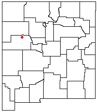
in northwest New Mexico
New Mexico
New Mexico is a state located in the southwest and western regions of the United States. New Mexico is also usually considered one of the Mountain States. With a population density of 16 per square mile, New Mexico is the sixth-most sparsely inhabited U.S...
, northeast of the town of Grants
Grants, New Mexico
Grants is a city in Cibola County, New Mexico, United States. The population was 9,182 at the 2010 Census. It is the county seat of Cibola County....
. It is the high point of the San Mateo Mountains
San Mateo Mountains (Cibola County, New Mexico)
The San Mateo Mountains are a small mountain range in Cibola and McKinley counties of New Mexico, in the southwestern United States. The highest point in the range is Mount Taylor, at 11,301 ft . The range lies just northeast of the community of Grants, and about 60 miles west of Albuquerque...
There are two small ranges in New Mexico called the San Mateo Mountains; this is the northern one. The other range
San Mateo Mountains (Socorro County, New Mexico)
The San Mateo Mountains are a small mountain range in Socorro County, in west-central New Mexico in the southwestern United States. The highest point in the range is West Blue Mountain, at 10,336 ft . The range runs roughly north-south and is about 40 miles long...
is near the Plains of San Agustin. and the highest point in the Cibola National Forest
Cibola National Forest
The Cibola National Forest is a United States National Forest in western and central New Mexico, USA. The forest also manages four National Grasslands that stretch from northeastern New Mexico eastward into the Texas Panhandle and western Oklahoma. It is administered by the United States Forest...
. It was named in 1849 for then president
President of the United States
The President of the United States of America is the head of state and head of government of the United States. The president leads the executive branch of the federal government and is the commander-in-chief of the United States Armed Forces....
Zachary Taylor
Zachary Taylor
Zachary Taylor was the 12th President of the United States and an American military leader. Initially uninterested in politics, Taylor nonetheless ran as a Whig in the 1848 presidential election, defeating Lewis Cass...
. Prior to that, it was called Cebolleta (tender onion) by the Spanish; the name persists as one name for the northern portion of the San Mateo Mountains, a large mesa
Mesa
A mesa or table mountain is an elevated area of land with a flat top and sides that are usually steep cliffs. It takes its name from its characteristic table-top shape....
. Mount Taylor is largely forested, rising like a blue cone above the desert below. Its slopes were an important source of lumber for neighboring pueblo
Pueblo
Pueblo is a term used to describe modern communities of Native Americans in the Southwestern United States of America. The first Spanish explorers of the Southwest used this term to describe the communities housed in apartment-like structures built of stone, adobe mud, and other local material...
s.
Native American traditions
To the Navajo peopleNavajo people
The Navajo of the Southwestern United States are the largest single federally recognized tribe of the United States of America. The Navajo Nation has 300,048 enrolled tribal members. The Navajo Nation constitutes an independent governmental body which manages the Navajo Indian reservation in the...
, Mount Taylor is , the turquoise mountain, one of the four sacred mountains marking the cardinal directions and the boundaries of the Dinetah
Dinetah
Dinétah is the traditional homeland of the Navajo tribe of Native Americans. In the Navajo language, the word means "among the people" or "among the Navajo"...
, the traditional Navajo homeland. Mount Taylor marks the southern boundary, and is associated with the direction south and the color blue; it is gendered female. In Navajo mythology, First Man created the sacred mountains from soil from the Fourth World, together with sacred matter, as replicas of mountains from that world. He fastened Mount Taylor to the earth with a stone knife. The supernatural beings Black God, Turquoise Boy, and Turquoise Girl are said to reside on the mountain.
Mount Taylor is also sacred to the Acoma
Acoma Pueblo
Acoma Pueblo is a Native American pueblo approximately 60 miles west of Albuquerque, New Mexico in the United States. Three reservations make up Acoma Pueblo: Sky City , Acomita, and McCartys. The Acoma Pueblo tribe is a federally recognized tribal entity...
, Laguna
Laguna Pueblo
Laguna is a Native American tribe of the Pueblo people in west-central New Mexico, USA. The name, Laguna, is Spanish and derives from the lake located on their reservation. The real Keresan name of the tribe is Kawaik. The population of the tribe exceeds 7,000 , making it the largest Keresan...
and Zuni people.
Volcanology
Mount Taylor was active from 3.3 to 1.5 million years agoduring the Pliocene
Pliocene
The Pliocene Epoch is the period in the geologic timescale that extends from 5.332 million to 2.588 million years before present. It is the second and youngest epoch of the Neogene Period in the Cenozoic Era. The Pliocene follows the Miocene Epoch and is followed by the Pleistocene Epoch...
, and is surrounded by a field of smaller inactive volcanoes. Repeated eruptions built lava dome
Lava dome
|250px|thumb|right|Image of the [[rhyolitic]] lava dome of [[Chaitén Volcano]] during its 2008–2009 eruption.In volcanology, a lava dome is a roughly circular mound-shaped protrusion resulting from the slow extrusion of viscous lava from a volcano...
s and produced lava
Lava
Lava refers both to molten rock expelled by a volcano during an eruption and the resulting rock after solidification and cooling. This molten rock is formed in the interior of some planets, including Earth, and some of their satellites. When first erupted from a volcanic vent, lava is a liquid at...
flows, ash plumes, and mudflow
Mudflow
A mudslide is the most rapid and fluid type of downhill mass wasting. It is a rapid movement of a large mass of mud formed from loose soil and water. Similar terms are mudflow, mud stream, debris flow A mudslide is the most rapid (up to 80 km/h, or 50 mph) and fluid type of downhill mass...
s. The mountain is surrounded by a great volume of volcanic debris, suggesting multiple major eruptions, possibly similar to that of Mount Saint Helens and the San Francisco Peaks
San Francisco Peaks
The San Francisco Peaks are a volcanic mountain range located in north central Arizona, just north of Flagstaff.The highest summit in the range, Humphreys Peak, is the highest point in the state of Arizona at in elevation. The San Francisco Peaks are the remains of an eroded stratovolcano...
near Flagstaff, Arizona
Flagstaff, Arizona
Flagstaff is a city located in northern Arizona, in the southwestern United States. In 2010, the city's population was 65,870. The population of the Metropolitan Statistical Area was at 134,421 in 2010. It is the county seat of Coconino County...
.
Estimates vary about how high the mountain was at its highest. Conservative estimates place its maximum near a similar pre-explosion height for the San Francisco Peaks
San Francisco Peaks
The San Francisco Peaks are a volcanic mountain range located in north central Arizona, just north of Flagstaff.The highest summit in the range, Humphreys Peak, is the highest point in the state of Arizona at in elevation. The San Francisco Peaks are the remains of an eroded stratovolcano...
of 16000 foot, and an extreme estimate places it near 25000 feet (7,620 m).
Mining
Mount Taylor is very rich in hot pockets a uraniumUranium
Uranium is a silvery-white metallic chemical element in the actinide series of the periodic table, with atomic number 92. It is assigned the chemical symbol U. A uranium atom has 92 protons and 92 electrons, of which 6 are valence electrons...
-vanadium
Vanadium
Vanadium is a chemical element with the symbol V and atomic number 23. It is a hard, silvery gray, ductile and malleable transition metal. The formation of an oxide layer stabilizes the metal against oxidation. The element is found only in chemically combined form in nature...
bearing mineral, and was mined extensively for it from 1979 to 1990. The Mount Taylor and the hundreds of other uranium mines on Pueblo lands have provided over thirteen million tons of uranium ore to the United States since 1945.
Concern has arisen regarding the impact of future mining activities on the site. In June 2008 the New Mexico Cultural Properties Review Committee voted in favor of a one year emergency listing of more than 422000 acres (170,777.5 ha) surrounding the mountain’s summit on the state Register of Cultural Properties. "The Navajo Nation, the Acoma, Laguna and Zuni pueblos, and the Hopi tribe of Arizona asked the state to approve the listing for a mountain they consider sacred to protect it from an anticipated uranium mining boom, according to the nomination report."
In April 2009, Mount Taylor was added to the National Trust for Historic Preservation
National Trust for Historic Preservation
The National Trust for Historic Preservation is an American member-supported organization that was founded in 1949 by congressional charter to support preservation of historic buildings and neighborhoods through a range of programs and activities, including the publication of Preservation...
's list of America's Most Endangered Places
America's Most Endangered Places
Each year since 1987, the National Trust for Historic Preservation has released a list of places they consider the most endangered in America. The number of sites included on the list has varied, with the most recent lists settling on 11...
.
See also
- Capulin Volcano National MonumentCapulin Volcano National MonumentCapulin Volcano National Monument, located in northeastern New Mexico, was designated a U.S. National Monument on August 9, 1916. It is an example of an extinct cinder cone volcano that is part of the Raton-Clayton Volcanic Field. A paved road spirals around the volcano and visitors can drive up...
- El Malpais National MonumentEl Malpais National MonumentEl Malpais National Monument is a National Monument located in western New Mexico, in the Southwestern United States. The name El Malpais is from the Spanish term Malpaís, meaning badlands, due to the extremely barren and dramatic volcanic field that covers much of the park's area.-Geography:The El...
- San Mateo Mountains (Cibola County, New Mexico)San Mateo Mountains (Cibola County, New Mexico)The San Mateo Mountains are a small mountain range in Cibola and McKinley counties of New Mexico, in the southwestern United States. The highest point in the range is Mount Taylor, at 11,301 ft . The range lies just northeast of the community of Grants, and about 60 miles west of Albuquerque...