

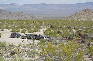
Mojave Road
Encyclopedia
Four-wheel drive
Four-wheel drive, 4WD, or 4×4 is a four-wheeled vehicle with a drivetrain that allows all four wheels to receive torque from the engine simultaneously...
road' across what is now the Mojave National Preserve
Mojave National Preserve
Mojave National Preserve is located in the Mojave Desert of San Bernardino County, California, USA, between Interstate 15 and Interstate 40. The preserve was established October 31, 1994 with the passage of the California Desert Protection Act by the US Congress...
in the Mojave Desert
Mojave Desert
The Mojave Desert occupies a significant portion of southeastern California and smaller parts of central California, southern Nevada, southwestern Utah and northwestern Arizona, in the United States...
of California
California
California is a state located on the West Coast of the United States. It is by far the most populous U.S. state, and the third-largest by land area...
, United States
United States
The United States of America is a federal constitutional republic comprising fifty states and a federal district...
.
History
A traditional thoroughfare of desert-dwelling Native AmericansNative Americans in the United States
Native Americans in the United States are the indigenous peoples in North America within the boundaries of the present-day continental United States, parts of Alaska, and the island state of Hawaii. They are composed of numerous, distinct tribes, states, and ethnic groups, many of which survive as...
, the road much later served Spanish missionaries, explorers, and foreign colonizers and settlers from the 18th to 19th centuries, and ran between watering holes across the Mojave Desert between the Colorado River
Colorado River
The Colorado River , is a river in the Southwestern United States and northwestern Mexico, approximately long, draining a part of the arid regions on the western slope of the Rocky Mountains. The watershed of the Colorado River covers in parts of seven U.S. states and two Mexican states...
and San Bernardino Mountains
San Bernardino Mountains
The San Bernardino Mountains are a short transverse mountain range north and east of San Bernardino in Southern California in the United States. The mountains run for approximately 60 miles east-west on the southern edge of the Mojave Desert in southwestern San Bernardino County, north of the...
in Southern California
Southern California
Southern California is a megaregion, or megapolitan area, in the southern area of the U.S. state of California. Large urban areas include Greater Los Angeles and Greater San Diego. The urban area stretches along the coast from Ventura through the Southland and Inland Empire to San Diego...
.. The watering holes recur at intervals of about 60 to 70 miles. The trail is 138 miles (222.1 km) long and usually requires 2 or 3 days to travel.
Francisco Garcés
Francisco Garcés
Francisco Hermenegildo Tomás Garcés was a Spanish Franciscan missionary who explored much of the southwestern part of North America, including what are now Arizona, southern California, and northeastern Baja California. Garcés was born April 12, 1738, in Morata de Jalón , Zaragoza province,...
, the Spanish Franciscan
Franciscan
Most Franciscans are members of Roman Catholic religious orders founded by Saint Francis of Assisi. Besides Roman Catholic communities, there are also Old Catholic, Anglican, Lutheran, ecumenical and Non-denominational Franciscan communities....
missionary
Missionary
A missionary is a member of a religious group sent into an area to do evangelism or ministries of service, such as education, literacy, social justice, health care and economic development. The word "mission" originates from 1598 when the Jesuits sent members abroad, derived from the Latin...
, traveled the trail with the expedition of Juan Bautista de Anza
Juan Bautista de Anza
Juan Bautista de Anza Bezerra Nieto was a Novo-Spanish explorer and Governor of New Mexico for the Spanish Empire.-Early life:...
in 1776. José María de Zalvidea, the zealous Franciscan administrator of Mission San Gabriel also crossed the trail in 1806, reportedly converting five indigenous Mohave
Mohave
Mohave or Mojave are a Native American people indigenous to the Colorado River in the Mojave Desert. The Fort Mojave Indian Reservation includes parts of California, Arizona, and Nevada...
Native Americans
Native Americans in the United States
Native Americans in the United States are the indigenous peoples in North America within the boundaries of the present-day continental United States, parts of Alaska, and the island state of Hawaii. They are composed of numerous, distinct tribes, states, and ethnic groups, many of which survive as...
near present-day Hesperia
Hesperia
Hesperia may refer to:Hesperia or Hesper is the Greek goddess of the evening star in Greek mythology,may refer to:* Hesperia, one of the Hesperides in Greek mythology...
. In 1826, Jedediah Smith
Jedediah Smith
Jedediah Strong Smith was a hunter, trapper, fur trader, trailblazer, author, cartographer, cattleman, and explorer of the Rocky Mountains, the American West Coast and the Southwest during the 19th century...
became the first American to travel the Mojave Road from Utah
Utah
Utah is a state in the Western United States. It was the 45th state to join the Union, on January 4, 1896. Approximately 80% of Utah's 2,763,885 people live along the Wasatch Front, centering on Salt Lake City. This leaves vast expanses of the state nearly uninhabited, making the population the...
to California.
The land passed to American hands in 1848, and the trail came under the purview of the U.S. government. Army posts were established at Fort Mojave
Fort Mojave
Fort Mohave was originally named Camp Colorado when it was established on April 19, 1859 by Lieutenant Colonel William Hoffman during the Mohave War...
in 1859 and at Camp Cady in 1860, with smaller outposts along the trail and regular patrols. The army protected the settlers and travelers from the territorial attacks of the resident Paiute, Mojave and Chemehuevi
Chemehuevi
The Chemehuevi are a federally recognized Native American tribe enrolled in the Chemehuevi Indian Tribe of the Chemehuevi Reservation. They are the southernmost branch of Paiutes.-Reservation:...
Native Americans
Native Americans in the United States
Native Americans in the United States are the indigenous peoples in North America within the boundaries of the present-day continental United States, parts of Alaska, and the island state of Hawaii. They are composed of numerous, distinct tribes, states, and ethnic groups, many of which survive as...
. This also opened the way for agricultural development in the Victor Valley area.
The eastern end of the Mojave Road begins at the edge of the Colorado River
Colorado River
The Colorado River , is a river in the Southwestern United States and northwestern Mexico, approximately long, draining a part of the arid regions on the western slope of the Rocky Mountains. The watershed of the Colorado River covers in parts of seven U.S. states and two Mexican states...
north of Needles, California
Needles, California
Needles is a city located in the Mojave Desert on the western banks of the Colorado River in San Bernardino County, California. It is located in the Mohave Valley, which straddles the California–Arizona border. The city is accessible via Interstate 40 and U.S. Route 95...
and the western terminus lies beyond the Rasor Off-Highway Vehicle Area
Rasor Off-Highway Vehicle Area
Rasor Off-Highway Vehicle Area is a remote public use area for the off-highway vehicle user located in the Mojave Desert about east of Barstow, California, administered by the Bureau of Land Management....
and the Afton Canyon Natural Area near the Manix Wash.
Traveling east to west
----- The Colorado RiverColorado RiverThe Colorado River , is a river in the Southwestern United States and northwestern Mexico, approximately long, draining a part of the arid regions on the western slope of the Rocky Mountains. The watershed of the Colorado River covers in parts of seven U.S. states and two Mexican states...
- Where the trail begins -mile 0 35.046280°N 114.627890°W - Piute Creek - Natural spring with trees and plants growing all year round. -mile 23 35.115020°N 114.985260°W
- Fort Piute - Next to the spring, this fort was built in 1867 by the US infantry -mile 23 35.115020°N 114.985260°W
- Lanfair Valley - Cattle ranches have been here since 1880. -mile 34 35.094780°N 115.019520°W
- Indian Hill, Indian Well - North of the Mojave Road at mile 40, there is an old well of debatable origin. -mile 40 35.143530°N 115.154260°W
- Joshua Tree Forest - The road gets very narrow in this thick forest in Lanfair Valley. -mile 47 35.143340°N 115.291460°W
- Rock Spring - The biggest watering hole along the Mojave Road. The stream flows down large boulders. There is an old cabin here. -mile 49 35.152830°N 115.327300°W
- Government Holes - Another water supply near Rock Spring, with an old concrete trough -mile 52 35.147490°N 115.359200°W
- Cedar Canyon - The highest point of the trip, crossing the Mid Hills you will reach 5000 ft (1,524 m) elevation -mile 56 35.152900°N 115.362000°W
- Kelso-Cima Road - In the middle of the trip, this is the last paved road you will see for a long time -mile 62 35.176210°N 115.509010°W
- Marl Springs - Another spring with a primitive concrete trough. -mile 70 35.170700°N 115.647590°W
- Mojave Road Mail Box - Sign your name at this solitary flagpole and continue on. -mile 74 35.185400°N 115.692840°W
- Willow Wash - Heavy sand alongside the Cinder Cones lava flow, parallels Kelbaker Rd. -mile 77 35.162850°N 115.842090°W
- Kelbaker Road - The paved road between Baker and Kelso Junction.35.2226°N 115.8789°W
- Soda Lake - A large dry lake; proceed with caution. You may have to drive around in the winter - mile 97 35.152410°N 116.052710°W
- Soda Springs (ZzyzxZzyzx, CaliforniaZzyzx, California , formerly Camp Soda and Soda Springs, is a settlement in San Bernardino County, California. It is the former site of the Zzyzx Mineral Springs and Health Spa and now the site of the Desert Studies Center...
) - Small private building on the edge of Soda Lake 35.142790°N 116.104740°W - Travelers Monument - Also known as Government Monument, travelers carry a rock across the dry lake and add it to the pile -mile 100 35.130840°N 116.095270°W
- Rasor OHV AreaRasor Off-Highway Vehicle AreaRasor Off-Highway Vehicle Area is a remote public use area for the off-highway vehicle user located in the Mojave Desert about east of Barstow, California, administered by the Bureau of Land Management....
- Open use area -mile 103 35.108780°N 116.143630°W - Sand Dunes - There are a few soft sand dunes along here that you can play on -mile 106 35.080507°N 116.193786°W
- Afton Canyon - Deep canyon with steep walls, riparian habitat]] restoration, and plenty of scenery -mile 116 35.042720°N 116.309500°W
- Mojave RiverMojave RiverThe Mojave River is an intermittent river in the eastern San Bernardino Mountains and Mojave Desert in San Bernardino County, California. The river is notable as most of its flow is underground, while its surface channels remain dry most of the time, with the exception of the headwaters and several...
crossing - The only water crossing on this trail -mile 121 35.037740°N 116.381120°W - Manix Wash - The exit point of the Mojave Road -mile 133 34.974380°N 116.540800°W
See also
Category: Mojave National PreserveCategory: Mountain ranges of the Mojave Desert
Category: Protected areas of the Mojave Desert
- Desert Region of CaliforniaDesert Region of CaliforniaThe Deserts of California have unique ecosystems and habitats, a sociocultural and historical "Old West" collection of legends, districts, and communities; and a popular tourism region of dramatic natural features and recreational development...