
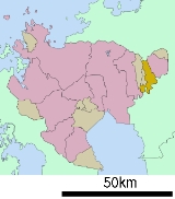
Miyaki, Saga
Encyclopedia
is a town
in Miyaki District
, Saga Prefecture
, Japan
. It is the first town in Saga to have its name spelled in hiragana
rather than kanji
. It is named after the district
it is located in.
and about 30 kilometres (18.6 mi) south of Fukuoka
. The northern part of Miyaki contains the Chikushi Mountains, and the southern part contains the Chikugo River
. It borders Fukuoka Prefecture
on the north and south.
Towns of Japan
A town is a local administrative unit in Japan. It is a local public body along with prefecture , city , and village...
in Miyaki District
Miyaki District, Saga
is a district located in Saga Prefecture, Japan.In February 2009, the district had an estimated population of 54,233 and a density of 625 per km²...
, Saga Prefecture
Saga Prefecture
is located in the northwest part of the island of Kyūshū, Japan. It touches both the Sea of Japan and the Ariake Sea. The western part of the prefecture is a region famous for producing ceramics and porcelain, particularly the towns of Karatsu, Imari, and Arita...
, Japan
Japan
Japan is an island nation in East Asia. Located in the Pacific Ocean, it lies to the east of the Sea of Japan, China, North Korea, South Korea and Russia, stretching from the Sea of Okhotsk in the north to the East China Sea and Taiwan in the south...
. It is the first town in Saga to have its name spelled in hiragana
Hiragana
is a Japanese syllabary, one basic component of the Japanese writing system, along with katakana, kanji, and the Latin alphabet . Hiragana and katakana are both kana systems, in which each character represents one mora...
rather than kanji
Kanji
Kanji are the adopted logographic Chinese characters hanzi that are used in the modern Japanese writing system along with hiragana , katakana , Indo Arabic numerals, and the occasional use of the Latin alphabet...
. It is named after the district
Districts of Japan
The was most recently used as an administrative unit in Japan between 1878 and 1921 and is roughly equivalent to the county of the United States, ranking at the level below prefecture and above city, town or village. As of 2008, cities belong directly to prefectures and are independent from...
it is located in.
Geography
Miyaki is located in the eastern part of Saga Prefecture, about 20 kilometres (12.4 mi) east of Saga CitySaga, Saga
is the capital of Saga Prefecture, located on the island of Kyūshū, Japan.Saga was the capital of Saga Domain in the Edo period, and largest city of former Hizen Province....
and about 30 kilometres (18.6 mi) south of Fukuoka
Fukuoka, Fukuoka
is the capital city of Fukuoka Prefecture and is situated on the northern shore of the island of Kyushu in Japan.Voted number 14 in a 2010 poll of the World's Most Livable Cities, Fukuoka is praised for its green spaces in a metropolitan setting. It is the most populous city in Kyushu, followed by...
. The northern part of Miyaki contains the Chikushi Mountains, and the southern part contains the Chikugo River
Chikugo River
The flows through Kumamoto, Ōita, Fukuoka and Saga prefectures in Japan. With a total length of , it is the longest river on Kyūshū. It flows from Mount Aso and empties into the Ariake Sea. It is also nicknamed "Chikushijirō"...
. It borders Fukuoka Prefecture
Fukuoka Prefecture
is a prefecture of Japan located on Kyūshū Island. The capital is the city of Fukuoka.- History :Fukuoka Prefecture includes the former provinces of Chikugo, Chikuzen, and Buzen....
on the north and south.
Adjoining municipalities
- Saga PrefectureSaga Prefectureis located in the northwest part of the island of Kyūshū, Japan. It touches both the Sea of Japan and the Ariake Sea. The western part of the prefecture is a region famous for producing ceramics and porcelain, particularly the towns of Karatsu, Imari, and Arita...
- KamimineKamimine, Sagais a town located in Miyaki District, Saga, Japan.-Geography:Kamimine is located in the eastern part of Saga Prefecture about east of central Saga, the capital city. It is also about west of Kurume, a major city in Fukuoka Prefecture. There is a lot of flat land in Kamimine as the town area...
- TosuTosu, Sagais a city located in the east part of Saga Prefecture on the island of Kyūshū, Japan.-Overview:Tosu is one of the major transportation hubs of Kyūshū. Its main train station is Tosu Station which connects the Nagasaki Main Line and the Kagoshima Main Line. There is also a junction connecting the...
- KanzakiKanzaki, Sagais a city located in Saga Prefecture, Japan. The city was created on March 20, 2006 by the merger of the towns of Kanzaki and Chiyoda, and the village of Sefuri, all from Kanzaki District...
- YoshinogariYoshinogari, Sagais a town located in Kanzaki District, Saga Prefecture, Japan. It is the result of a merger between the town of Mitagawa, and the village of Higashisefuri, both from Kanzaki District, on March 1, 2006.-Geography:...
- Kamimine
- Fukuoka PrefectureFukuoka Prefectureis a prefecture of Japan located on Kyūshū Island. The capital is the city of Fukuoka.- History :Fukuoka Prefecture includes the former provinces of Chikugo, Chikuzen, and Buzen....
- KurumeKurume, Fukuokais a city located in Fukuoka prefecture, Japan.The city has an estimated population of 303,277 and a population density of 1,319.51 persons per km²...
- NakagawaNakagawa, Fukuokais a town located in Chikushi District, Fukuoka, Japan.As of 2003, the town has an estimated population of 46,540 and a density of 620.62 persons per km². The total area is 74.99 km².-External links:*...
- Kurume
History
- April 1, 1889 - The present system of municipalities is established and the area occupied by Miyaki consists of the villages of Nakabaru, Kitashigeyasu, Minamishigeyasu, and Mikawa.
- April 1, 1955 - The villages Minamishigeyasu and Nakabaru merge to form Mine Village.
- May 5, 1962 - Mine Village becomes Mine Town.
- April 1 1965 - Kitashigeyasu Village becomes Kitashigeyasu Town.
- April 1, 1971 - Nakabaru Village becomes Nakabaru Town.
- March 1, 2005 - The towns of Mine, Kitashigeyasu and Nakabaru merge to form Miyaki Town.
Junior High Schools
- Nakabaru Junior High School
- Kitashigeyasu Junior High School
- Mine Junior High School
Elementary Schools
- Nakabaru Elementary School
- Kitashigeyasu Elementary School
- Mine Higashi Elementary School
- Mine Nishi Elementary School
Road
- ExpresswaysExpressways of JapanThe expressways of Japan make up a large network of freeway-standard toll roads.- History :Following World War II, Japan's economic revival led to a massive increase in personal automobile use...
:- There are no expressways in Miyaki. The closest interchangeInterchange (road)In the field of road transport, an interchange is a road junction that typically uses grade separation, and one or more ramps, to permit traffic on at least one highway to pass through the junction without directly crossing any other traffic stream. It differs from a standard intersection, at which...
is the Higashisefuri Interchange.
- There are no expressways in Miyaki. The closest interchange
- National highwaysNational highways of JapanJapan has a nationwide system of distinct from the expressways. The Ministry of Land, Infrastructure and Transport and other government agencies administer the national highways. Beginning in 1952, Japan classified these as Class 1 or Class 2. Class 1 highways had one- or two-digit numbers, while...
:- Route 34
- Route 264Route 264 (Japan)National Route 264 is a national highway of Japan connecting Saga, Saga and Kurume, Fukuoka in Japan, with a total length of 27.4 km ....
- Prefectural roads:
- Saga Prefectural Routes 19, 22 and 31