
Kamimine, Saga
Encyclopedia
is a town
located in Miyaki District
, Saga
, Japan
.
about 15 kilometres (9.3 mi) east of central Saga
, the capital city. It is also about 15 kilometres (9.3 mi) west of Kurume
, a major city in Fukuoka Prefecture
. There is a lot of flat land in Kamimine as the town area consists largely of the Saga Plain
s. However, the northern part of town contains Mt. Chinzei.
in neighboring Yoshinogari
.
Towns of Japan
A town is a local administrative unit in Japan. It is a local public body along with prefecture , city , and village...
located in Miyaki District
Miyaki District, Saga
is a district located in Saga Prefecture, Japan.In February 2009, the district had an estimated population of 54,233 and a density of 625 per km²...
, Saga
Saga Prefecture
is located in the northwest part of the island of Kyūshū, Japan. It touches both the Sea of Japan and the Ariake Sea. The western part of the prefecture is a region famous for producing ceramics and porcelain, particularly the towns of Karatsu, Imari, and Arita...
, Japan
Japan
Japan is an island nation in East Asia. Located in the Pacific Ocean, it lies to the east of the Sea of Japan, China, North Korea, South Korea and Russia, stretching from the Sea of Okhotsk in the north to the East China Sea and Taiwan in the south...
.
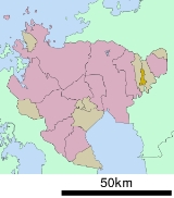
Geography
Kamimine is located in the eastern part of Saga PrefectureSaga Prefecture
is located in the northwest part of the island of Kyūshū, Japan. It touches both the Sea of Japan and the Ariake Sea. The western part of the prefecture is a region famous for producing ceramics and porcelain, particularly the towns of Karatsu, Imari, and Arita...
about 15 kilometres (9.3 mi) east of central Saga
Saga, Saga
is the capital of Saga Prefecture, located on the island of Kyūshū, Japan.Saga was the capital of Saga Domain in the Edo period, and largest city of former Hizen Province....
, the capital city. It is also about 15 kilometres (9.3 mi) west of Kurume
Kurume, Fukuoka
is a city located in Fukuoka prefecture, Japan.The city has an estimated population of 303,277 and a population density of 1,319.51 persons per km²...
, a major city in Fukuoka Prefecture
Fukuoka Prefecture
is a prefecture of Japan located on Kyūshū Island. The capital is the city of Fukuoka.- History :Fukuoka Prefecture includes the former provinces of Chikugo, Chikuzen, and Buzen....
. There is a lot of flat land in Kamimine as the town area consists largely of the Saga Plain
Plain
In geography, a plain is land with relatively low relief, that is flat or gently rolling. Prairies and steppes are types of plains, and the archetype for a plain is often thought of as a grassland, but plains in their natural state may also be covered in shrublands, woodland and forest, or...
s. However, the northern part of town contains Mt. Chinzei.
History
- April 1, 1889 - The modern municipal systemMunicipalities of JapanJapan has three levels of government: national, prefectural, and municipal. The nation is divided into 47 prefectures. Each prefecture consists of numerous municipalities. There are four types of municipalities in Japan: cities, towns, villages and special wards...
is established. The villages of Bōsho, Emukai, Maemuta and Tsutsumi merge to form Kamimine. - November 1, 1989 - Kamimine gains townTowns of JapanA town is a local administrative unit in Japan. It is a local public body along with prefecture , city , and village...
status.
Rail
The Nagasaki Main Line runs through Kamimine, but there are no stations within the town borders. The closest station is Yoshinogari-kōen StationYoshinogari-koen Station
is a train station in Yoshinogari, Kanzaki District, Saga Prefecture, Japan. It is operated by JR Kyushu and is on the Nagasaki Main Line.-Layout:...
in neighboring Yoshinogari
Yoshinogari, Saga
is a town located in Kanzaki District, Saga Prefecture, Japan. It is the result of a merger between the town of Mitagawa, and the village of Higashisefuri, both from Kanzaki District, on March 1, 2006.-Geography:...
.
Road
- ExpresswaysExpressways of JapanThe expressways of Japan make up a large network of freeway-standard toll roads.- History :Following World War II, Japan's economic revival led to a massive increase in personal automobile use...
: The Nagasaki ExpresswayNagasaki Expressway' is one of the Expressways of Japan from Tosu to Nagasaki. It runs through the prefecture of Saga, and the southern half of the Nagasaki prefecture...
runs through Kamimine, but there are no interchangeInterchange (road)In the field of road transport, an interchange is a road junction that typically uses grade separation, and one or more ramps, to permit traffic on at least one highway to pass through the junction without directly crossing any other traffic stream. It differs from a standard intersection, at which...
s within the town borders. The closest interchange is the Higashisefuri Interchange in neighboring Yoshinogari. - National highwaysNational highways of JapanJapan has a nationwide system of distinct from the expressways. The Ministry of Land, Infrastructure and Transport and other government agencies administer the national highways. Beginning in 1952, Japan classified these as Class 1 or Class 2. Class 1 highways had one- or two-digit numbers, while...
: Route 34 - Main prefectural roads: Kitashigeyasu-Mitagawa Route 22