

Districts of Japan
Encyclopedia
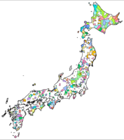
The was most recently used as an administrative unit in Japan
Japan
Japan is an island nation in East Asia. Located in the Pacific Ocean, it lies to the east of the Sea of Japan, China, North Korea, South Korea and Russia, stretching from the Sea of Okhotsk in the north to the East China Sea and Taiwan in the south...
between 1878 and 1921 and is roughly equivalent to the county
County
A county is a jurisdiction of local government in certain modern nations. Historically in mainland Europe, the original French term, comté, and its equivalents in other languages denoted a jurisdiction under the sovereignty of a count A county is a jurisdiction of local government in certain...
of the United States
United States
The United States of America is a federal constitutional republic comprising fifty states and a federal district...
, ranking at the level below prefecture
Prefectures of Japan
The prefectures of Japan are the country's 47 subnational jurisdictions: one "metropolis" , Tokyo; one "circuit" , Hokkaidō; two urban prefectures , Osaka and Kyoto; and 43 other prefectures . In Japanese, they are commonly referred to as...
and above city
Cities of Japan
||A is a local administrative unit in Japan. Cities are ranked on the same level as and , with the difference that they are not a component of...
, town
Towns of Japan
A town is a local administrative unit in Japan. It is a local public body along with prefecture , city , and village...
or village
Villages of Japan
A is a local administrative unit in Japan.It is a local public body along with , , and . Geographically, a village's extent is contained within a prefecture....
. As of 2008, cities belong directly to prefectures and are independent from districts. In Japan towns and villages belong to districts and the districts possess little to no administrative authority. The districts are used primarily in the Japanese addressing system
Japanese addressing system
The Japanese addressing system is used to identify a specific location in Japan. In Japanese, addresses are written using the opposite convention from Western addresses, starting with the biggest geographical entities down to the more specific ones....
and to identify the relevant geographical areas and collections of nearby towns and villages.
The district was initially called kōri and has ancient roots in Japan. Although the Nihon Shoki
Nihon Shoki
The , sometimes translated as The Chronicles of Japan, is the second oldest book of classical Japanese history. It is more elaborate and detailed than the Kojiki, the oldest, and has proven to be an important tool for historians and archaeologists as it includes the most complete extant historical...
says they were established during the Taika Reform
Taika Reform
The ' were a set of doctrines established by Emperor Kōtoku in the year 645. They were written shortly after the death of Prince Shōtoku, and the defeat of the Soga clan , uniting Japan. Crown Prince Naka no Ōe , Nakatomi no Kamatari, and Emperor Kōtoku jointly embarked on the details of the Reforms...
s, kōri was originally written 評. It was not until the Taihō Code
Taiho Code
The was an administrative reorganization enacted in 701 in Japan, at the end of the Asuka period. It was historically one of the . It was compiled at the direction of Prince Osakabe, Fujiwara no Fuhito and Awata no Mahito...
that kōri came to be written 郡. Under the Taihō Code, the administrative unit of province (国; kuni) was above district, and the village (里; sato or 郷; sato) was below.
Confusing cases in Hokkaidō
Because district names had been unique within a single provinceProvinces of Japan
Before the modern prefecture system was established, the land of Japan was divided into tens of kuni , usually known in English as provinces. Each province was divided into gun ....
and as of 2008 prefecture
Prefectures of Japan
The prefectures of Japan are the country's 47 subnational jurisdictions: one "metropolis" , Tokyo; one "circuit" , Hokkaidō; two urban prefectures , Osaka and Kyoto; and 43 other prefectures . In Japanese, they are commonly referred to as...
boundaries are roughly aligned to provincial boundaries, most district names are unique within their prefectures.
Hokkaidō Prefecture
Hokkaido
, formerly known as Ezo, Yezo, Yeso, or Yesso, is Japan's second largest island; it is also the largest and northernmost of Japan's 47 prefectural-level subdivisions. The Tsugaru Strait separates Hokkaido from Honshu, although the two islands are connected by the underwater railway Seikan Tunnel...
, however, came much later to the ritsuryō
Ritsuryo
is the historical law system based on the philosophies of Confucianism and Chinese Legalism in Japan. The political system in accord to Ritsuryō is called "Ritsuryō-sei"...
provincial system, only a few years before the prefectural system was introduced, thus its eleven province
Provinces of Japan
Before the modern prefecture system was established, the land of Japan was divided into tens of kuni , usually known in English as provinces. Each province was divided into gun ....
s included several districts with the same names:
- Three Kamikawa Districts and two Nakagawa Districts in the Hokkaidō PrefectureHokkaido, formerly known as Ezo, Yezo, Yeso, or Yesso, is Japan's second largest island; it is also the largest and northernmost of Japan's 47 prefectural-level subdivisions. The Tsugaru Strait separates Hokkaido from Honshu, although the two islands are connected by the underwater railway Seikan Tunnel...
. Each jurisdiction refers to its geographical position along the river from which the former province, and subsequent subprefecture, takes its name. "Kamikawa" means upper course of the river; "Nakagawa" means middle course.- Kamikawa Dist.Kamikawa (Ishikari) District, Hokkaidois a district located in Kamikawa Subprefecture, Hokkaidō, Japan. Confusingly, there is a district of the same name, Kamikawa District, in the same subprefecture. In 1869, Hokkaidō was divided into 11 provinces and 86 districts. Kamikawa district was placed under Ishikari Province...
(IshikariIshikari Provincewas a short-lived province located in Hokkaidō. It corresponded to modern-day Ishikari Subprefecture minus Chitose and Eniwa, all of Sorachi Subprefecture and the southern half of Kamikawa Subprefecture excluding Shimukappu-History:...
), managed by the Kamikawa SubprefectureKamikawa Subprefectureis a subprefecture of Hokkaidō, Japan. The name is derived from Kamikawa no hitobito no Shūraku , a translation of the Ainu Peni Unguri Kotan. Settlement began in 1867... - Kamikawa Dist.Kamikawa (Teshio) District, Hokkaidois a district located in Kamikawa Subprefecture, Hokkaidō, Japan. Confusingly, there is a district of the same name, Kamikawa District, in the same subprefecture. When Hokkaidō was divided into provinces and districts, this district was placed under Teshio Province...
(TeshioTeshio Provincewas a short-lived province located in Hokkaidō, corresponding to all of modern-day Rumoi Subprefecture and the northern half of Kamikawa Subprefecture.-History:...
), managed by the Kamikawa SubprefectureKamikawa Subprefectureis a subprefecture of Hokkaidō, Japan. The name is derived from Kamikawa no hitobito no Shūraku , a translation of the Ainu Peni Unguri Kotan. Settlement began in 1867... - Kamikawa Dist. (TokachiTokachi Provincewas a short-lived province in Hokkaidō. It corresponded to modern-day Tokachi Subprefecture.-History:After 1869, the northern Japanese island was known as Hokkaido; and regional administrative subdivisions were identified, including Tokachi Province....
), managed by the Tokachi SubprefectureTokachi Subprefectureis a subprefecture of Hokkaidō, Japan corresponding to the old province of Tokachi. As of 2004 its estimated population is 360,802 and its area is 10,830.99 km².Tokachi-Obihiro Airport is in the city of Obihiro.- Geography :-Towns and villages by district:... - Nakagawa Dist.Nakagawa (Teshio) District, Hokkaidois a district located in Kamikawa Subprefecture, Hokkaidō, Japan. A district with the same name exists in Tokachi Subprefecture.As of 2004, the district has an estimated population of 9,038 and a density of 5.86 persons per km². The total area is 1,542.65 km².-Towns and...
(TeshioTeshio Provincewas a short-lived province located in Hokkaidō, corresponding to all of modern-day Rumoi Subprefecture and the northern half of Kamikawa Subprefecture.-History:...
), managed by the Kamikawa SubprefectureKamikawa Subprefectureis a subprefecture of Hokkaidō, Japan. The name is derived from Kamikawa no hitobito no Shūraku , a translation of the Ainu Peni Unguri Kotan. Settlement began in 1867... - Nakagawa Dist.Nakagawa (Tokachi) District, Hokkaidois a district located in Tokachi Subprefecture, Hokkaidō, Japan. There is a district with the same name in Kamikawa Subprefecture, see Nakagawa District, Hokkaidō....
(TokachiTokachi Provincewas a short-lived province in Hokkaidō. It corresponded to modern-day Tokachi Subprefecture.-History:After 1869, the northern Japanese island was known as Hokkaido; and regional administrative subdivisions were identified, including Tokachi Province....
), managed by the Tokachi SubprefectureTokachi Subprefectureis a subprefecture of Hokkaidō, Japan corresponding to the old province of Tokachi. As of 2004 its estimated population is 360,802 and its area is 10,830.99 km².Tokachi-Obihiro Airport is in the city of Obihiro.- Geography :-Towns and villages by district:...
- Kamikawa Dist.
- Abuta District, Rumoi District, Sorachi District, and Yufutsu District are similar, but each of them is a single district allotted to two subprefecturesSubprefectures of JapanCertain prefectures of Japan are now, or once were, divided into subprefectures. The subprefecture is the jurisdiction surrounding a of the prefectural government. Normally, the area of a subprefecture consists of a few to a dozen cities, towns, and/or villages. Subprefectures are formed to...
.- Abuta DistrictAbuta District, Hokkaidois a district located in Iburi and Shiribeshi Subprefectures in Hokkaidō, Japan.As of 2004, the district has an estimated population of 31,526 and a density of 28.30 persons per km²...
, managed by IburiIburi Subprefectureis a subprefecture of Hokkaidō, Japan.- Geography :Located in south-central Hokkaido, Iburi stretches East-West and North-South. Iburi covers an area of . Iburi borders Oshima subprefecture to the West, Shiribeshi, Ishikari, and Sorachi subprefectures to the North, and Hidaka subprefecture to the...
and Shiribeshi SubprefectureShiribeshi Subprefectureis a subprefecture of Hokkaidō, Japan. The subprefecture's capital is Kutchan. As of July 31, 2004, the estimated population was 256,184 and the area was 4,305.65 km².- Towns and villages by district :* Abuta District** Kimobetsu...
s - Sorachi DistrictSorachi District, Hokkaidois a district divided between Sorachi and Kamikawa Subprefectures, Hokkaidō. As of 2004, the district has an estimated population of 53,011 and an area of 1,497.21 km², giving a population density of 35.41 persons per square kilometer.-Towns and Villages:...
, managed by KamikawaKamikawa Subprefectureis a subprefecture of Hokkaidō, Japan. The name is derived from Kamikawa no hitobito no Shūraku , a translation of the Ainu Peni Unguri Kotan. Settlement began in 1867...
and Sorachi SubprefectureSorachi Subprefectureis a subprefecture of Hokkaidō, Japan. As of 2004, its estimated population is 373,736 and its area is 6,558.26 km².-Cities:* Akabira* Ashibetsu* Bibai* Fukagawa* Iwamizawa * Mikasa* Sunagawa* Takikawa* Utashinai* Yūbari...
s - Teshio DistrictTeshio District, Hokkaidois a district divided between Rumoi Subprefecture and Sōya Subprefecture, Hokkaidō. At the end of 2009, the district has an estimated population of 13,937 and an area of 2039.11 km², giving a population density of 6.83 persons per square kilometer.-Towns:...
, managed by RumoiRumoi Subprefectureis a subprefecture of Hokkaidō, Japan. As of 2004, it had a population of 63,406 and an area of 4,019.97km².-Towns and villages by district:* Mashike District** Mashike* Rumoi District** Obira* Teshio District** Enbetsu** Horonobe** Teshio...
and Sōya SubprefectureSoya Subprefectureis a subprefecture of Hokkaidō, Japan. Its population is estimated to be 77,500 as of July 31, 2004 and its area is 4,050.84 km². It is the northernmost subprefecture of Japan.Wakkanai Airport is located in Wakkanai...
s - Yūfutsu DistrictYufutsu District, Hokkaidois a district divided between Iburi and Kamikawa Subprefectures.-Towns and villages:*Iburi**Abira **Atsuma**Mukawa*Kamikawa**Shimukappu-History:...
, managed by IburiIburi Subprefectureis a subprefecture of Hokkaidō, Japan.- Geography :Located in south-central Hokkaido, Iburi stretches East-West and North-South. Iburi covers an area of . Iburi borders Oshima subprefecture to the West, Shiribeshi, Ishikari, and Sorachi subprefectures to the North, and Hidaka subprefecture to the...
and Kamikawa SubprefectureKamikawa Subprefectureis a subprefecture of Hokkaidō, Japan. The name is derived from Kamikawa no hitobito no Shūraku , a translation of the Ainu Peni Unguri Kotan. Settlement began in 1867...
s
- Abuta District