
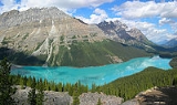
Peyto Lake
Encyclopedia
Peyto Lake is a glacier
-fed lake
located in Banff National Park
in the Canadian Rockies
. The lake itself is easily accessed from the Icefields Parkway
. It was named for Bill Peyto
, an early trail guide and trapper in the Banff area.
The lake is formed in a valley of the Waputik Range
, between Caldron Peak, Peyto Peak
and Mount Jimmy Simpson, at an elevation of 1860 m (6,102.4 ft).
During the summer, significant amounts of glacial rock flour
flow into the lake, and these suspended rock particles give the lake a bright, turquoise color. Because of its bright color, photos of the lake often appear in illustrated books, and area around the lake is a popular sightseeing spot for tourists in the park. The lake is best seen from Bow Summit, the highest point on the Icefield Parkway.
The lake is fed by the Peyto Creek, which drains water from the Caldron Lake and Peyto Glacier
(part of the Wapta Icefield
), and flows into the Mistaya River
.
Glacier
A glacier is a large persistent body of ice that forms where the accumulation of snow exceeds its ablation over many years, often centuries. At least 0.1 km² in area and 50 m thick, but often much larger, a glacier slowly deforms and flows due to stresses induced by its weight...
-fed lake
Lake
A lake is a body of relatively still fresh or salt water of considerable size, localized in a basin, that is surrounded by land. Lakes are inland and not part of the ocean and therefore are distinct from lagoons, and are larger and deeper than ponds. Lakes can be contrasted with rivers or streams,...
located in Banff National Park
Banff National Park
Banff National Park is Canada's oldest national park, established in 1885 in the Rocky Mountains. The park, located 110–180 kilometres west of Calgary in the province of Alberta, encompasses of mountainous terrain, with numerous glaciers and ice fields, dense coniferous forest, and alpine...
in the Canadian Rockies
Canadian Rockies
The Canadian Rockies comprise the Canadian segment of the North American Rocky Mountains range. They are the eastern part of the Canadian Cordillera, extending from the Interior Plains of Alberta to the Rocky Mountain Trench of British Columbia. The southern end borders Idaho and Montana of the USA...
. The lake itself is easily accessed from the Icefields Parkway
Icefields Parkway
The Icefields Parkway , also known as Highway 93 north, is a scenic road in Alberta, Canada. It parallels the Continental Divide, traversing the rugged landscape of the Canadian Rockies, travelling through Banff National Park and Jasper National Park. It links Lake Louise with Jasper to the north....
. It was named for Bill Peyto
Bill Peyto
Ebenezer William "Bill" Peyto was a pioneer, mountain guide, and early park warden of the Banff National Park. As a guide, Peyto was chosen to lead Edward Whymper to Vermilion Pass. His large photograph prominently marks the entrance to the town of Banff, Alberta...
, an early trail guide and trapper in the Banff area.
The lake is formed in a valley of the Waputik Range
Waputik Range
The Waputik Range lies West of the upper Bow Valley, East of Bath Creek, South of Balfour Creek in the Canadian Rockies."Waputik" means "white goat" in Stoney...
, between Caldron Peak, Peyto Peak
Peyto Peak
Peyto Peak is a mountain in the Waputik Range, part of the Canadian Rockies in Alberta, Canada.It lies at the north end of the Wapta Icefield, in Banff National Park, about one km east of the border with British Columbia and north of the town of Field. Five kilometres to the northeast lies Bow...
and Mount Jimmy Simpson, at an elevation of 1860 m (6,102.4 ft).
During the summer, significant amounts of glacial rock flour
Rock flour
Rock flour, or glacial flour, consists of fine-grained, silt-sized particles of rock, generated by mechanical grinding of bedrock by glacial erosion or by artificial grinding to a similar size...
flow into the lake, and these suspended rock particles give the lake a bright, turquoise color. Because of its bright color, photos of the lake often appear in illustrated books, and area around the lake is a popular sightseeing spot for tourists in the park. The lake is best seen from Bow Summit, the highest point on the Icefield Parkway.
The lake is fed by the Peyto Creek, which drains water from the Caldron Lake and Peyto Glacier
Peyto Glacier
Peyto Glacier is located in the Canadian Rockies in Banff National Park, Alberta, Canada, approximately northwest of the town of Banff, and can be accessed from the Icefields Parkway. Peyto Glacier is an outflow glacier from the Wapta Icefield, which rests along the Continental divide...
(part of the Wapta Icefield
Wapta Icefield
The Wapta Icefield is located on the Continental Divide in the Canadian Rockies, in the provinces of British Columbia and Alberta. The icefield is shared by Banff and Yoho National Parks and numerous outlet glaciers extend from the icefield, including the Vulture, Bow and Peyto Glaciers...
), and flows into the Mistaya River
Mistaya River
Mistaya River is a short river in western Alberta, Canada. It flows through the Canadian Rockies, and a section of the Icefield Parkway was built along its course....
.