
Milan, New York
Encyclopedia
Milan is a town
in Dutchess County
, New York
, United States
. The Town of Milan is in the northern part of the county.
 The area that comprises Milan today was the western part of the Little Nine Partners Patent
of 1706. Milan was largely a farming and mill town and remains a very rural town today.
The first settler in the area was Johannes Rowe. The son of a Palatine
immigrant, Rowe bought 911 acres (3.7 km²) from Robert Livingston
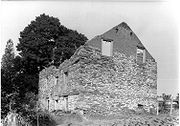
and built a stone house in 1766 on what is now Rowe Road near the Milan Town Hall. The remains of the house were photographed in 1940 for the Historic American Buildings Survey
.
The New York State Legislature voted on March 6, 1818 to create the town of Milan from the western part of the Town of North East
-- to be effective "from and after the last day in March" 1818. The session laws stated that the first town meeting would be held the first Tuesday of April and at the home of Stephen Thorn who was elected Town Supervisor
along with John F. Bartlett, Town Clerk.
Two 19th century histories of the town of Milan and Dutchess County (1877 and 1882) state there is no knowledge or evidence as to why the name "Milan" was chosen.
But the name Milan had appeared in other areas of the state and it was not unusual to take European city names at the time. What is now the City of Syracuse
was known as Milan for a brief period between 1809 and 1812. A settlement 40 miles (64.4 km) south of Syracuse was originally called Milan in 1790 before incorporation in 1802 as the Town of Locke. An unincorporated village there continued to be referred to as Milan but gave up its Milan Post Office designation on July 29, 1817, becoming "Locke" Post Office. This cleared the way for the operation of the Milan Post Office on August 14, 1818 at what is now Case's Corners.
So in 1818 the name "Milan" was secured for both the town and one of the hamlet Post Offices.
The main thoroughfares for the community ran from the Hudson River
to Salisbury, CT and travelers referred to the road as the "turnpike." It later became recognized as the Salisbury Turnpike and sections of the road still exist today and bear that name.
In addition to farming and local mills in Milan, lead and iron were mined in areas around what is now Millerton, NY and Salisbury, CT which was then brought to Livingston's Furnaces at Ancram in Columbia County. Milan was "in-between" those towns and the river and as a result had a great deal of important commercial traffic going east/west through the town.
The early population peaked in 1840 at 1,745 residents and went into decline until 1930 with only 622 residents. It was the opening of the Erie Canal
(1825) and then the development of the railroad and the move to river cities and the western migration that caused the decline. Also, Milan's soil was hilly and rocky and tough to farm. Then following the 1930s and the Great Depression
the population grew again, due in part to the construction of the Taconic Parkway which ended in Milan at the time, and then the post World War II
boom.
The 1840 population level was reached again in 1980, some 140 years later. From the 1980s to the turn of the new century Milan was one of the fastest-growing towns in Dutchess County.
Milan remains the least populous town in Dutchess County.
Partial list of New York State Historic Markers in Milan:
the town has a total area of 36.3 square miles (94.0 km²), of which, 36.1 square miles (93.5 km²) of it is land and 0.2 square miles (0.5 km²) of it (0.52%) is water.
The north town line is the border of Columbia County
, New York
.
The Taconic State Parkway
runs north/south along the eastern part of the town. The entire highway, including its supporting structures, are listed on the National Register of Historic Places
.
New York State Route 199
runs east/west through the town of Milan—going to Red Hook
and over the Kingston–Rhinecliff Bridge to the west. It is the direct route to Pine Plains
and Millerton to the east.
New York State Route 308
connects Route 199
in southwest Milan to Rhinebeck
. It is a short state highway, only 6.19 miles (9.96 km) in length.
owns, manages and maintains two Multiple Use Areas in Milan. Both are east of the Taconic State Parkway
.
The Lafayetteville Multiple Use Area comprises 769 acres (3.1 km²) with an entrance on Route 199 between the Taconic State Parkway
and New York State Route 82
.
The Roeliff Jansen Kill Multiple Use Area is 125 acre (0.5058575 km²) and is accessed from a pull-off on the east side of the Taconic State Parkway near the Roeliff Jansen Kill.
Dutchess County
owns, manages and maintains the 615 acres (2.5 km²) Wilcox Memorial Park on Route 199—3.4 miles east of Taconic State Parkway.
The town of Milan owns, manages and maintains the Milan Rec Park on South Road. It contains a softball field, children's play area and has a trail maintained by the Milaners Youth Group. It is also the location of the recycling and transfer station.
Dutchess County Tourism offers scenic driving tour that includes the town.
The original proposal included almost 1,000 homes along with golf courses. Durst’s January 2010 revised plans would allow for 624 homes (572 in Pine Plains and 52 in Milan).
By 2002 Red Wing Sand and Gravel of East Fishkill, New York
had bought two large parcels in the northern part of the Milan (269 acres (1.1 km²) on Turkey Hill Road and 163 acre (0.65963818 km²) on Academy Hill Road) with a view to operating two large-scale mines. But on March 30, 2010 the Supreme Court of the State of New York ruled in favor of the Town of Milan and its town-wide ban on mining. The town was defended successfully by the office of the New York State Attorney General, preventing the mining company from proceeding to develop mines at those locations.
As of the census
of 2000, there were 4,559 people, 882 households, and 612 families residing in the town. The population density
was 126.3 people per square mile (48.8/km²). There were 1,090 housing units at an average density of 30.2 per square mile (11.7/km²). The racial makeup of the town was 60.63% White, 27.22% African American, 0.66% Native American, 0.75% Asian, 0.04% Pacific Islander, 9.87% from other races
, and 0.83% from two or more races. Hispanic or Latino of any race were 15.68% of the population.
There were 882 households out of which 35.7% had children under the age of 18 living with them, 58.5% were married couples
living together, 6.8% had a female householder with no husband present, and 30.6% were non-families. 23.7% of all households were made up of individuals and 8.0% had someone living alone who was 65 years of age or older. The average household size was 2.62 and the average family size was 3.14.
In the town the population was spread out with 14.2% under the age of 18, 7.7% from 18 to 24, 49.8% from 25 to 44, 21.7% from 45 to 64, and 6.6% who were 65 years of age or older. The median age was 37 years. For every 100 females there were 299.6 males. For every 100 females age 18 and over, there were 364.2 males.
The median income for a household in the town was $54,491, and the median income for a family was $65,250. Males had a median income of $26,473 versus $27,500 for females. The per capita income
for the town was $19,002. About 2.8% of families and 4.6% of the population were below the poverty line, including 4.6% of those under age 18 and 6.3% of those age 65 or over.

Town
A town is a human settlement larger than a village but smaller than a city. The size a settlement must be in order to be called a "town" varies considerably in different parts of the world, so that, for example, many American "small towns" seem to British people to be no more than villages, while...
in Dutchess County
Dutchess County, New York
Dutchess County is a county located in the U.S. state of New York, in the state's Mid-Hudson Region of the Hudson Valley. The 2010 census lists the population as 297,488...
, New York
New York
New York is a state in the Northeastern region of the United States. It is the nation's third most populous state. New York is bordered by New Jersey and Pennsylvania to the south, and by Connecticut, Massachusetts and Vermont to the east...
, United States
United States
The United States of America is a federal constitutional republic comprising fifty states and a federal district...
. The Town of Milan is in the northern part of the county.
History
Little Nine Partners Patent
The Little Nine Partners Patent was the final patent granted in Dutchess County, New York, USA. It was located in the northern part of the county, and comprises all or parts of the modern towns of Milan, Pine Plains, and North East...
of 1706. Milan was largely a farming and mill town and remains a very rural town today.
The first settler in the area was Johannes Rowe. The son of a Palatine
Palatine
A palatine or palatinus is a high-level official attached to imperial or royal courts in Europe since Roman times...
immigrant, Rowe bought 911 acres (3.7 km²) from Robert Livingston
Robert Livingston (1708-1790)
Robert Livingston was the third Lord of Livingston Manor. He was son of Philip Livingston and was a member of the assembly for the manor from 1737 to 1758....
and built a stone house in 1766 on what is now Rowe Road near the Milan Town Hall. The remains of the house were photographed in 1940 for the Historic American Buildings Survey
Historic American Buildings Survey
The Historic American Buildings Survey , Historic American Engineering Record , and Historic American Landscapes Survey are programs of the National Park Service established for the purpose of documenting historic places. Records consists of measured drawings, archival photographs, and written...
.
Town and Post Office est. 1818
The New York State Legislature voted on March 6, 1818 to create the town of Milan from the western part of the Town of North East
North East, New York
North East is a town in Dutchess County, New York, United States. The population was 3,002 at the 2000 census.The Town of North East is in the northeastern part of the county...
-- to be effective "from and after the last day in March" 1818. The session laws stated that the first town meeting would be held the first Tuesday of April and at the home of Stephen Thorn who was elected Town Supervisor
Town supervisor
Town Supervisor is an elective legislative position in New York towns. Supervisors sit on the town board, where they preside over town board meetings and vote on all matters with no more legal weight than that of any other board member .Towns may adopt local laws that allow them to provide for an...
along with John F. Bartlett, Town Clerk.
Two 19th century histories of the town of Milan and Dutchess County (1877 and 1882) state there is no knowledge or evidence as to why the name "Milan" was chosen.
But the name Milan had appeared in other areas of the state and it was not unusual to take European city names at the time. What is now the City of Syracuse
Syracuse, New York
Syracuse is a city in and the county seat of Onondaga County, New York, United States, the largest U.S. city with the name "Syracuse", and the fifth most populous city in the state. At the 2010 census, the city population was 145,170, and its metropolitan area had a population of 742,603...
was known as Milan for a brief period between 1809 and 1812. A settlement 40 miles (64.4 km) south of Syracuse was originally called Milan in 1790 before incorporation in 1802 as the Town of Locke. An unincorporated village there continued to be referred to as Milan but gave up its Milan Post Office designation on July 29, 1817, becoming "Locke" Post Office. This cleared the way for the operation of the Milan Post Office on August 14, 1818 at what is now Case's Corners.
So in 1818 the name "Milan" was secured for both the town and one of the hamlet Post Offices.
A town "in-between"
The main thoroughfares for the community ran from the Hudson River
Hudson River
The Hudson is a river that flows from north to south through eastern New York. The highest official source is at Lake Tear of the Clouds, on the slopes of Mount Marcy in the Adirondack Mountains. The river itself officially begins in Henderson Lake in Newcomb, New York...
to Salisbury, CT and travelers referred to the road as the "turnpike." It later became recognized as the Salisbury Turnpike and sections of the road still exist today and bear that name.
In addition to farming and local mills in Milan, lead and iron were mined in areas around what is now Millerton, NY and Salisbury, CT which was then brought to Livingston's Furnaces at Ancram in Columbia County. Milan was "in-between" those towns and the river and as a result had a great deal of important commercial traffic going east/west through the town.
Remains least populous town
The early population peaked in 1840 at 1,745 residents and went into decline until 1930 with only 622 residents. It was the opening of the Erie Canal
Erie Canal
The Erie Canal is a waterway in New York that runs about from Albany, New York, on the Hudson River to Buffalo, New York, at Lake Erie, completing a navigable water route from the Atlantic Ocean to the Great Lakes. The canal contains 36 locks and encompasses a total elevation differential of...
(1825) and then the development of the railroad and the move to river cities and the western migration that caused the decline. Also, Milan's soil was hilly and rocky and tough to farm. Then following the 1930s and the Great Depression
Great Depression
The Great Depression was a severe worldwide economic depression in the decade preceding World War II. The timing of the Great Depression varied across nations, but in most countries it started in about 1929 and lasted until the late 1930s or early 1940s...
the population grew again, due in part to the construction of the Taconic Parkway which ended in Milan at the time, and then the post World War II
World War II
World War II, or the Second World War , was a global conflict lasting from 1939 to 1945, involving most of the world's nations—including all of the great powers—eventually forming two opposing military alliances: the Allies and the Axis...
boom.
The 1840 population level was reached again in 1980, some 140 years later. From the 1980s to the turn of the new century Milan was one of the fastest-growing towns in Dutchess County.
Milan remains the least populous town in Dutchess County.
State Historic Markers
Partial list of New York State Historic Markers in Milan:
- Jackson Corners—Colonial Inn: Built About 1773 Stage Inn, Doctor's Office, Hotel, Store, Post Office Of Jackson Corners.
- Jackson Corners—Nobletown Road: Running From Post Road In Livingston, Through Gallatin, Ancram, State Line, Nobletown, To Barrington, N.H. In Use Before 1798.
- Turkey Hill Road—Fulton Homestead: John Fulton, First Owner. Deed Recorded Oct. 12, 1795 Has Always Been In Possession Of The Fulton Family. In Fulton Name Until 1933.
- Turkey Hill Road—Burial Ground: Chief Crow And Other Mohican Shacomecos Of Moravian Faith Buried Here. Last Burial About 1850.
Geography & Roads
According to the United States Census BureauUnited States Census Bureau
The United States Census Bureau is the government agency that is responsible for the United States Census. It also gathers other national demographic and economic data...
the town has a total area of 36.3 square miles (94.0 km²), of which, 36.1 square miles (93.5 km²) of it is land and 0.2 square miles (0.5 km²) of it (0.52%) is water.
The north town line is the border of Columbia County
Columbia County, New York
Columbia County is a county located in the U.S. state of New York. As of the 2010 census, the population was 63,096. The county seat is Hudson. The name comes from the Latin feminine form of the name of Christopher Columbus, which was at the time of the formation of the county a popular proposal...
, New York
New York
New York is a state in the Northeastern region of the United States. It is the nation's third most populous state. New York is bordered by New Jersey and Pennsylvania to the south, and by Connecticut, Massachusetts and Vermont to the east...
.
The Taconic State Parkway
Taconic State Parkway
The Taconic State Parkway , is a divided highway between Kensico Dam and Chatham, the longest parkway in the U.S. state of New York. It follows a generally northward route midway between the Hudson River and the Connecticut and Massachusetts state lines...
runs north/south along the eastern part of the town. The entire highway, including its supporting structures, are listed on the National Register of Historic Places
National Register of Historic Places
The National Register of Historic Places is the United States government's official list of districts, sites, buildings, structures, and objects deemed worthy of preservation...
.
New York State Route 199
New York State Route 199
New York State Route 199 is a state highway located in the Hudson Valley of New York in the United States. It extends for from an interchange with U.S. Route 9W and US 209 north of Kingston to an intersection with US 44 and NY 22 southwest of Millerton...
runs east/west through the town of Milan—going to Red Hook
Red Hook, New York
Red Hook is a town in Dutchess County, New York, United States. The population was reported to be 11,319 during the 2010 census. The name is supposedly derived from the red foliage on trees on a small strip of land on the Hudson River. The town contains two villages; the village of Red Hook and the...
and over the Kingston–Rhinecliff Bridge to the west. It is the direct route to Pine Plains
Pine Plains (town), New York
Pine Plains is a town in Dutchess County, New York, USA. The population was 2,569 at the 2000 census. The name is derived from the geographic character of the region.The Hamlet of Pine Plains is on the north border of the county.-History:...
and Millerton to the east.
New York State Route 308
New York State Route 308
New York State Route 308 is a short state highway, in length, located entirely in northern Dutchess County, in the U.S. state of New York. It is a major collector road through mostly rural areas that serves primarily as a shortcut for traffic from the two main north–south routes in the area,...
connects Route 199
New York State Route 199
New York State Route 199 is a state highway located in the Hudson Valley of New York in the United States. It extends for from an interchange with U.S. Route 9W and US 209 north of Kingston to an intersection with US 44 and NY 22 southwest of Millerton...
in southwest Milan to Rhinebeck
Rhinebeck (town), New York
Rhinebeck is a town in Dutchess County, New York, United States. The population was 7,548 at the 2010 census.The Town of Rhinebeck in the northwest part of Dutchess County in the Hudson Valley. Rhinebeck is also the name of a village in the town. US Route 9 passes through the town...
. It is a short state highway, only 6.19 miles (9.96 km) in length.
Parks & Recreation
The New York State Department of Environmental ConservationNew York State Department of Environmental Conservation
The New York State Department of Environmental Conservation is responsible for the conservation, improvement, and protection of natural resources within the U.S. state of New York. It was founded in 1970, replacing the previous Conservation Department...
owns, manages and maintains two Multiple Use Areas in Milan. Both are east of the Taconic State Parkway
Taconic State Parkway
The Taconic State Parkway , is a divided highway between Kensico Dam and Chatham, the longest parkway in the U.S. state of New York. It follows a generally northward route midway between the Hudson River and the Connecticut and Massachusetts state lines...
.
The Lafayetteville Multiple Use Area comprises 769 acres (3.1 km²) with an entrance on Route 199 between the Taconic State Parkway
Taconic State Parkway
The Taconic State Parkway , is a divided highway between Kensico Dam and Chatham, the longest parkway in the U.S. state of New York. It follows a generally northward route midway between the Hudson River and the Connecticut and Massachusetts state lines...
and New York State Route 82
New York State Route 82
New York State Route 82 is a state highway in the eastern Hudson Valley of New York, United States. It begins at an intersection with NY 52 northeast of the village of Fishkill, bends eastward towards Millbrook, and then returns westward to end at a junction with U.S. Route 9,...
.
The Roeliff Jansen Kill Multiple Use Area is 125 acre (0.5058575 km²) and is accessed from a pull-off on the east side of the Taconic State Parkway near the Roeliff Jansen Kill.
Dutchess County
Dutchess County, New York
Dutchess County is a county located in the U.S. state of New York, in the state's Mid-Hudson Region of the Hudson Valley. The 2010 census lists the population as 297,488...
owns, manages and maintains the 615 acres (2.5 km²) Wilcox Memorial Park on Route 199—3.4 miles east of Taconic State Parkway.
The town of Milan owns, manages and maintains the Milan Rec Park on South Road. It contains a softball field, children's play area and has a trail maintained by the Milaners Youth Group. It is also the location of the recycling and transfer station.
Dutchess County Tourism offers scenic driving tour that includes the town.
Development pressures
In 2002 the Durst Organization, largely known for its high-rise developments in Manhattan, bought 2300 acres (9.3 km²) that straddle the town of Milan and Pine Plains with plans to create a second home and recreational community.The original proposal included almost 1,000 homes along with golf courses. Durst’s January 2010 revised plans would allow for 624 homes (572 in Pine Plains and 52 in Milan).
By 2002 Red Wing Sand and Gravel of East Fishkill, New York
East Fishkill, New York
East Fishkill is a town on the southern border of Dutchess County, New York, United States. The population was 25,589 at the 2000 census. The town name is derived from its formation from Fishkill, NY....
had bought two large parcels in the northern part of the Milan (269 acres (1.1 km²) on Turkey Hill Road and 163 acre (0.65963818 km²) on Academy Hill Road) with a view to operating two large-scale mines. But on March 30, 2010 the Supreme Court of the State of New York ruled in favor of the Town of Milan and its town-wide ban on mining. The town was defended successfully by the office of the New York State Attorney General, preventing the mining company from proceeding to develop mines at those locations.
Demographics
The 2000 Census was corrected due to an error in the total population count of Milan. Corrected population counts result from a process called the Count Question Resolution Program. Milan's total population in 2000 was 2,356, not 4,559 as originally reported. Due to the original error in total population, The US Census Bureau corrected four categories; Total Population, Total Housing Units, Vacant Housing Units and Group Quarters Population. They failed to correct any other data rendering the 2000 Census useless for demographic study. The resulting demographic data cited below is from the 2000 Census with almost all of it being incorrect.As of the census
Census
A census is the procedure of systematically acquiring and recording information about the members of a given population. It is a regularly occurring and official count of a particular population. The term is used mostly in connection with national population and housing censuses; other common...
of 2000, there were 4,559 people, 882 households, and 612 families residing in the town. The population density
Population density
Population density is a measurement of population per unit area or unit volume. It is frequently applied to living organisms, and particularly to humans...
was 126.3 people per square mile (48.8/km²). There were 1,090 housing units at an average density of 30.2 per square mile (11.7/km²). The racial makeup of the town was 60.63% White, 27.22% African American, 0.66% Native American, 0.75% Asian, 0.04% Pacific Islander, 9.87% from other races
Race (United States Census)
Race and ethnicity in the United States Census, as defined by the Federal Office of Management and Budget and the United States Census Bureau, are self-identification data items in which residents choose the race or races with which they most closely identify, and indicate whether or not they are...
, and 0.83% from two or more races. Hispanic or Latino of any race were 15.68% of the population.
There were 882 households out of which 35.7% had children under the age of 18 living with them, 58.5% were married couples
Marriage
Marriage is a social union or legal contract between people that creates kinship. It is an institution in which interpersonal relationships, usually intimate and sexual, are acknowledged in a variety of ways, depending on the culture or subculture in which it is found...
living together, 6.8% had a female householder with no husband present, and 30.6% were non-families. 23.7% of all households were made up of individuals and 8.0% had someone living alone who was 65 years of age or older. The average household size was 2.62 and the average family size was 3.14.
In the town the population was spread out with 14.2% under the age of 18, 7.7% from 18 to 24, 49.8% from 25 to 44, 21.7% from 45 to 64, and 6.6% who were 65 years of age or older. The median age was 37 years. For every 100 females there were 299.6 males. For every 100 females age 18 and over, there were 364.2 males.
The median income for a household in the town was $54,491, and the median income for a family was $65,250. Males had a median income of $26,473 versus $27,500 for females. The per capita income
Per capita income
Per capita income or income per person is a measure of mean income within an economic aggregate, such as a country or city. It is calculated by taking a measure of all sources of income in the aggregate and dividing it by the total population...
for the town was $19,002. About 2.8% of families and 4.6% of the population were below the poverty line, including 4.6% of those under age 18 and 6.3% of those age 65 or over.
Communities and locations in Milan
- Jackson Corners – In the northeast part of town on the Roeliff Jansen Kill. Jackson Corners Post Office ran from 1835 to 1860 and 1862 to 1930. In 1840, it had one Church and 25 houses.
- Lafayetteville – A hamlet east of Milan village, formerly called Lafayetter Corners. It was named after the Marquis de Lafayette, who visited the area in 1824. The Post Office ran from 1849 to 1903.
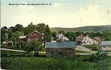
- Milanville – Location of the "Milan" Post Office from 1818 to 1908 and located at the junction of Salisbury Turnkpike and Milan Hollow Road this area is now known as "Case's Corner" after Rensselaer Case.
- Rock City – A hamlet west of Milan village had a grist and saw mill and 20 houses in 1840. It was formerly Travers Mill. Post Office ran from 1835 to 1904.
- Shookville – A former community in the northwest part of the town founded by Jacob Shook. Post Office ran from 1827 to 1835.