

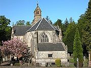
Mid Calder
Encyclopedia
Mid Calder is a town in West Lothian
, Scotland
. It is located on a steep hill overlooking the River Almond
and Calder Wood, around 15 miles (24.1 km) west of Edinburgh
. The town has been on a major crossroads since its origin sometime in the eleventh century.
, in the 14th century. During the Wars of Scottish Independence
, Sir James de Sandilands distinguished himself in the wars against the English. For his services he was rewarded with a royal charter
of his lands by David II of Scotland
. James was well connected and married Eleanor, the only daughter of Sir Archibald Douglas, Regent of Scotland. The gift included extensive estates in what is now West Lothian, and the Barony of Calder. After the Reformation
in 1560, Sir James Sandilands
, the head of the Sandilands family
, was created Lord Torphichen
. Since 1348 the family seat has been at Calder House, near to the middle of the village.
 For centuries a large part of the economy of the Scottish Highlands
revolved around the breeding and trading of Highland cattle
. They were moved along drove roads from all parts of the country, including some of the islands, to tryst
s or markets held in Crieff
and Falkirk
. Most of the cattle would then be driven south to feed consumers in England
. Several of the drove routes used came together at Mid Calder. Huge herds of cattle would come across fords or bridges over the River Almond
before crossing the Pentland Hills
to West Linton
. The peak year was 1840 when some 150,000 cattle passed through the area over the three months from August to October. This traffic helped support no fewer than nine public house
s in the village.
Meanwhile, Mid Calder also lay on the main turnpike
road from Edinburgh
to Glasgow
, adding a steady flow of east-west traffic to the seasonal influx of drovers heading south. However, the importance of the turnpike lessened at the same time as the cattle droving stopped, and for the same reason: the railways. And for once the acumen and foresight that had allowed the Sandilands to retain their position for so many centuries missed a beat. When the railway came to West Lothian in 1848, the then Lord Torphichen decreed that it should not come near Calder House.
As a result Mid Calder was served by a station at Kirknewton
, three miles away. This meant that adapting to the loss of its traditional sources of income could have been difficult for the village. But at precisely the right moment the world's first oil
boom occurred, in West Lothian
. This was based on oil extracted from shale
, and by 1870 over 3 million tons of shale
were being mined each year in the area around Mid Calder. Output declined with the discovery of liquid oil reserves around the world in the early 1900s, but shale mining only finally ceased in 1962. The "bings" that characterise oil shale mining elsewhere in West Lothian
have largely been flattened around Mid Calder and the land reclaimed for recreation, industry and housing.
Another major factor leading to Mid Calder's current prosperity has been the dramatic growth of nearby Livingston, now the second largest settlement in the Lothians and whose main shopping centre is only a mile to the west.
Mid Calder is also home to Lodge St John Mid Calder number 272 on the Roll of the Grand Lodge of Scotland. This Freemason lodge was formed on the 4th May 1818 (although Freemasonry was active in the area since at least the 1750s). Since 1936 the lodge has owned its own building at the entrance of the Calder Wood Country Park.
The outlying areas of Mid Calder were heavily built upon in the 1980s, and as a result, middle-class housing estates are a stone-throw away from both Calder House and woodlands.
In 2005, Mid Calder was subject to unwanted publicity when it became the first place in Britain to issue an ASBO
in a village-wide crackdown on the anti-social behaviour of drunken teenagers. The ASBO allowed police to disperse any young person found outdoors. After one month of operation, the order was deemed a success and to this day, Mid Calder remains one Central Scotland's most desirable village locations.
West Lothian
West Lothian is one of the 32 unitary council areas in Scotland, and a Lieutenancy area. It borders the City of Edinburgh, Falkirk, North Lanarkshire, the Scottish Borders and South Lanarkshire....
, Scotland
Scotland
Scotland is a country that is part of the United Kingdom. Occupying the northern third of the island of Great Britain, it shares a border with England to the south and is bounded by the North Sea to the east, the Atlantic Ocean to the north and west, and the North Channel and Irish Sea to the...
. It is located on a steep hill overlooking the River Almond
River Almond, Lothian
The River Almond is a river in east-central Scotland. It is 28 miles long, rising in North Lanarkshire near Shotts and runs through West Lothian, draining into the Firth of Forth at Cramond near Edinburgh....
and Calder Wood, around 15 miles (24.1 km) west of Edinburgh
Edinburgh
Edinburgh is the capital city of Scotland, the second largest city in Scotland, and the eighth most populous in the United Kingdom. The City of Edinburgh Council governs one of Scotland's 32 local government council areas. The council area includes urban Edinburgh and a rural area...
. The town has been on a major crossroads since its origin sometime in the eleventh century.
History
James Sandilands received the lands of Calder from his brother in law, William IV, Lord of DouglasWilliam IV, Lord of Douglas
William, Lord of Douglas was a short-lived Scottish nobleman, the son of Sir James Douglas and an unknown mother. Little is known of Lord Douglas's life, which he spent under the guardianship of Sir Archibald Douglas....
, in the 14th century. During the Wars of Scottish Independence
Wars of Scottish Independence
The Wars of Scottish Independence were a series of military campaigns fought between the independent Kingdom of Scotland and the Kingdom of England in the late 13th and early 14th centuries....
, Sir James de Sandilands distinguished himself in the wars against the English. For his services he was rewarded with a royal charter
Royal Charter
A royal charter is a formal document issued by a monarch as letters patent, granting a right or power to an individual or a body corporate. They were, and are still, used to establish significant organizations such as cities or universities. Charters should be distinguished from warrants and...
of his lands by David II of Scotland
David II of Scotland
David II was King of Scots from 7 June 1329 until his death.-Early life:...
. James was well connected and married Eleanor, the only daughter of Sir Archibald Douglas, Regent of Scotland. The gift included extensive estates in what is now West Lothian, and the Barony of Calder. After the Reformation
Scottish Reformation
The Scottish Reformation was Scotland's formal break with the Papacy in 1560, and the events surrounding this. It was part of the wider European Protestant Reformation; and in Scotland's case culminated ecclesiastically in the re-establishment of the church along Reformed lines, and politically in...
in 1560, Sir James Sandilands
James Sandilands, 1st Lord Torphichen
James Sandilands was born circa 1511 in Calder, West Lothian, Scotland, and died in 1596.He was the second son of Sir James Sandilands, 7th Lord of Calder...
, the head of the Sandilands family
Clan Sandilands
Clan Sandilands is a Lowland Scottish clan. Sandilands is also considered a sept of Clan Douglas.-Origins of the Clan:The name Sandilands comes from lands by that name in Clydesdale...
, was created Lord Torphichen
Lord Torphichen
Lord Torphichen is a title in the Peerage of Scotland. It was created by Queen Mary in 1564 for Sir James Sandilands , with remainder to his heirs and assigns whatsoever. Sandilands had previously served as Preceptor of the Order of St John of Jerusalem, of Rhodes, and of Malta in Scotland, and...
. Since 1348 the family seat has been at Calder House, near to the middle of the village.
Scottish Highlands
The Highlands is an historic region of Scotland. The area is sometimes referred to as the "Scottish Highlands". It was culturally distinguishable from the Lowlands from the later Middle Ages into the modern period, when Lowland Scots replaced Scottish Gaelic throughout most of the Lowlands...
revolved around the breeding and trading of Highland cattle
Highland cattle
Highland cattle or kyloe are a Scottish breed of beef cattle with long horns and long wavy coats which are coloured black, brindled, red, yellow or dun....
. They were moved along drove roads from all parts of the country, including some of the islands, to tryst
Tryst
Tryst may refer to:*A meeting of two lovers, as in courtship*Tryst , a book by Elswyth Thane*Tryst , a play by Karoline Leach*A nightclub at the Wynn Las Vegas hotel...
s or markets held in Crieff
Crieff
Crieff is a market town in Perth and Kinross, Scotland. It lies on the A85 road between Perth and Crianlarich and also lies on the A822 between Greenloaning and Aberfeldy. The A822 joins onto the A823 which leads to Dunfermline....
and Falkirk
Falkirk
Falkirk is a town in the Central Lowlands of Scotland. It lies in the Forth Valley, almost midway between the two most populous cities of Scotland; north-west of Edinburgh and north-east of Glasgow....
. Most of the cattle would then be driven south to feed consumers in England
England
England is a country that is part of the United Kingdom. It shares land borders with Scotland to the north and Wales to the west; the Irish Sea is to the north west, the Celtic Sea to the south west, with the North Sea to the east and the English Channel to the south separating it from continental...
. Several of the drove routes used came together at Mid Calder. Huge herds of cattle would come across fords or bridges over the River Almond
River Almond, Lothian
The River Almond is a river in east-central Scotland. It is 28 miles long, rising in North Lanarkshire near Shotts and runs through West Lothian, draining into the Firth of Forth at Cramond near Edinburgh....
before crossing the Pentland Hills
Pentland Hills
The Pentland Hills are a range of hills to the south-west of Edinburgh, Scotland. The range is around 20 miles in length, and runs south west from Edinburgh towards Biggar and the upper Clydesdale.Some of the peaks include:* Scald Law...
to West Linton
West Linton
West Linton is a village and civil parish in southern Scotland, on the A702. It was formerly in the county of Peeblesshire, but since local government re-organisation in the mid-1990s it is now part of the Tweeddale committee area of the Scottish Borders. Many residents are commuters due to the...
. The peak year was 1840 when some 150,000 cattle passed through the area over the three months from August to October. This traffic helped support no fewer than nine public house
Public house
A public house, informally known as a pub, is a drinking establishment fundamental to the culture of Britain, Ireland, Australia and New Zealand. There are approximately 53,500 public houses in the United Kingdom. This number has been declining every year, so that nearly half of the smaller...
s in the village.
Meanwhile, Mid Calder also lay on the main turnpike
Turnpike trust
Turnpike trusts in the United Kingdom were bodies set up by individual Acts of Parliament, with powers to collect road tolls for maintaining the principal highways in Britain from the 17th but especially during the 18th and 19th centuries...
road from Edinburgh
Edinburgh
Edinburgh is the capital city of Scotland, the second largest city in Scotland, and the eighth most populous in the United Kingdom. The City of Edinburgh Council governs one of Scotland's 32 local government council areas. The council area includes urban Edinburgh and a rural area...
to Glasgow
Glasgow
Glasgow is the largest city in Scotland and third most populous in the United Kingdom. The city is situated on the River Clyde in the country's west central lowlands...
, adding a steady flow of east-west traffic to the seasonal influx of drovers heading south. However, the importance of the turnpike lessened at the same time as the cattle droving stopped, and for the same reason: the railways. And for once the acumen and foresight that had allowed the Sandilands to retain their position for so many centuries missed a beat. When the railway came to West Lothian in 1848, the then Lord Torphichen decreed that it should not come near Calder House.
As a result Mid Calder was served by a station at Kirknewton
Kirknewton railway station
Kirknewton railway station is a railway station serving Kirknewton in West Lothian, Scotland, Opened as Kirknewton in February 1848, the station was renamed Midcalder and Kirknewton after two months, before becoming Midcalder in 1855. The full circle was finally completed 127 years later in May...
, three miles away. This meant that adapting to the loss of its traditional sources of income could have been difficult for the village. But at precisely the right moment the world's first oil
Oil
An oil is any substance that is liquid at ambient temperatures and does not mix with water but may mix with other oils and organic solvents. This general definition includes vegetable oils, volatile essential oils, petrochemical oils, and synthetic oils....
boom occurred, in West Lothian
West Lothian
West Lothian is one of the 32 unitary council areas in Scotland, and a Lieutenancy area. It borders the City of Edinburgh, Falkirk, North Lanarkshire, the Scottish Borders and South Lanarkshire....
. This was based on oil extracted from shale
Shale
Shale is a fine-grained, clastic sedimentary rock composed of mud that is a mix of flakes of clay minerals and tiny fragments of other minerals, especially quartz and calcite. The ratio of clay to other minerals is variable. Shale is characterized by breaks along thin laminae or parallel layering...
, and by 1870 over 3 million tons of shale
Shale
Shale is a fine-grained, clastic sedimentary rock composed of mud that is a mix of flakes of clay minerals and tiny fragments of other minerals, especially quartz and calcite. The ratio of clay to other minerals is variable. Shale is characterized by breaks along thin laminae or parallel layering...
were being mined each year in the area around Mid Calder. Output declined with the discovery of liquid oil reserves around the world in the early 1900s, but shale mining only finally ceased in 1962. The "bings" that characterise oil shale mining elsewhere in West Lothian
West Lothian
West Lothian is one of the 32 unitary council areas in Scotland, and a Lieutenancy area. It borders the City of Edinburgh, Falkirk, North Lanarkshire, the Scottish Borders and South Lanarkshire....
have largely been flattened around Mid Calder and the land reclaimed for recreation, industry and housing.
Another major factor leading to Mid Calder's current prosperity has been the dramatic growth of nearby Livingston, now the second largest settlement in the Lothians and whose main shopping centre is only a mile to the west.
Mid Calder is also home to Lodge St John Mid Calder number 272 on the Roll of the Grand Lodge of Scotland. This Freemason lodge was formed on the 4th May 1818 (although Freemasonry was active in the area since at least the 1750s). Since 1936 the lodge has owned its own building at the entrance of the Calder Wood Country Park.
The outlying areas of Mid Calder were heavily built upon in the 1980s, and as a result, middle-class housing estates are a stone-throw away from both Calder House and woodlands.
In 2005, Mid Calder was subject to unwanted publicity when it became the first place in Britain to issue an ASBO
Åsbo
Åsbo can refer to:*Åsbo Northern Hundred, a hundred in Scania*Åsbo Southern Hundred, a hundred in Scania...
in a village-wide crackdown on the anti-social behaviour of drunken teenagers. The ASBO allowed police to disperse any young person found outdoors. After one month of operation, the order was deemed a success and to this day, Mid Calder remains one Central Scotland's most desirable village locations.
External links
- Local History Link http://ads.ahds.ac.uk/catalogue/adsdata/PSAS_2002/pdf/vol_043/43_324_329.pdf