
Mid-Peninsula Highway
Encyclopedia
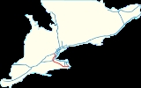
The Mid-Peninsula Highway is a proposed freeway across the Niagara Peninsula
in the Canadian
province of Ontario
. Although plans for a highway connecting Hamilton to Fort Erie south of the Niagara Escarpment
have surfaced for decades,
it was not until The Niagara Frontier International Gateway Study was published by the Ministry of Transportation of Ontario (MTO) in 1998 that serious examination and planning began. The study called for an alternative route to the QEW, which runs through tender fruitlands and is not capable of expansion beyond its current configuration. The land on which studies are being performed for this future freeway is referred to as the Mid-Peninsula Corridor or the Niagara–GTA Corrdior.
with a twinned Peace Bridge
in Fort Erie
. North of Hamilton, it would curve and meet Highway 407 or Highway 401 north of Burlington
. The entire freeway would be above the Niagara Escarpment in consideration of the wine
-producing fruitlands that lie at its base; a consideration that was ignored during the construction of the QEW despite the protests of farmers.
Connections with the southward extension of Highway 406 would be provided near Welland
, as well as with the controlled-access section of Highway 6 north of Caledonia
, where the freeway would pass near Hamilton International Airport
. The majority of the route west of the Welland Canal
would travel north of the former Highway 20
.
and Ernie Eves
planned to forego a full environmental assessment of the freeway after a study indicated an urgent need for its construction. The Niagara Frontier International Gateway Study was published by the MTO in 1998 and indicated that the freeway was of vital importance. Prior to this study, various proposals for a freeway above the Niagara Escarpment had surfaced for several decades, though no serious examination of its merits was undertaken.
However, with the election of the Liberal government under Dalton McGuinty
in 2003, a formal study was initiated. After developing the Growth Plan for the Greater Golden Horseshoe, the McGuinty government launched a new Niagara to GTA corridor environmental assessment to study transportation needs in the corridor.
A draft Transportation Development Study to consider alternative or complimentary infrastructure to a freeway was completed in February 2011. The study recommended the routing be split into three groups, with route planning to commence for the eastern portion, further corridor study in the western portion and to halt but otherwise continue monitoring needs for a new transportation link in the central portion. As a result of the study, the Regional Municipality of Niagara has initiated an environmental assessment to identify and design a new 400-series highway freeway Highway 406 and the QEW, forming the eastern portion of the Mid-Peninsula Highway. Corridor planning has the support of the provincial government.
The new highway has cropped up as a major issue in the upcoming provincial elections
. Progressive Conservative Leader Tim Hudak
has made a commitment to constructing the full length of the highway immediately, as it is heavily supported in the Niagara Region.
Niagara Peninsula
The Niagara Peninsula is the portion of Southern Ontario, Canada lying between the south shore of Lake Ontario and the north shore of Lake Erie. It stretches from the Niagara River in the east to Hamilton, Ontario in the west. The population of the peninsula is roughly 1,000,000 people...
in the Canadian
Canada
Canada is a North American country consisting of ten provinces and three territories. Located in the northern part of the continent, it extends from the Atlantic Ocean in the east to the Pacific Ocean in the west, and northward into the Arctic Ocean...
province of Ontario
Ontario
Ontario is a province of Canada, located in east-central Canada. It is Canada's most populous province and second largest in total area. It is home to the nation's most populous city, Toronto, and the nation's capital, Ottawa....
. Although plans for a highway connecting Hamilton to Fort Erie south of the Niagara Escarpment
Niagara Escarpment
The Niagara Escarpment is a long escarpment, or cuesta, in the United States and Canada that runs westward from New York State, through Ontario, Michigan, Wisconsin and Illinois...
have surfaced for decades,
it was not until The Niagara Frontier International Gateway Study was published by the Ministry of Transportation of Ontario (MTO) in 1998 that serious examination and planning began. The study called for an alternative route to the QEW, which runs through tender fruitlands and is not capable of expansion beyond its current configuration. The land on which studies are being performed for this future freeway is referred to as the Mid-Peninsula Corridor or the Niagara–GTA Corrdior.
Route description
As proposed, the Mid-Peninsula Highway would connect Highway 403 in HamiltonHamilton, Ontario
Hamilton is a port city in the Canadian province of Ontario. Conceived by George Hamilton when he purchased the Durand farm shortly after the War of 1812, Hamilton has become the centre of a densely populated and industrialized region at the west end of Lake Ontario known as the Golden Horseshoe...
with a twinned Peace Bridge
Peace Bridge
The Peace Bridge is an international bridge between Canada and the United States at the east end of Lake Erie at the source of the Niagara River, about upriver of Niagara Falls. It connects the City of Buffalo, New York, in the United States to the Town of Fort Erie, Ontario, in Canada...
in Fort Erie
Fort Erie, Ontario
Fort Erie is a town on the Niagara River in the Niagara Region, Ontario, Canada. It is located directly across the river from Buffalo, New York....
. North of Hamilton, it would curve and meet Highway 407 or Highway 401 north of Burlington
Burlington, Ontario
Burlington , is a city located in Halton Region at the western end of Lake Ontario. Burlington is part of the Greater Toronto Area, and is also included in the Hamilton Census Metropolitan Area. Physically, Burlington lies between the north shore of Lake Ontario and the Niagara Escarpment...
. The entire freeway would be above the Niagara Escarpment in consideration of the wine
Wine
Wine is an alcoholic beverage, made of fermented fruit juice, usually from grapes. The natural chemical balance of grapes lets them ferment without the addition of sugars, acids, enzymes, or other nutrients. Grape wine is produced by fermenting crushed grapes using various types of yeast. Yeast...
-producing fruitlands that lie at its base; a consideration that was ignored during the construction of the QEW despite the protests of farmers.
Connections with the southward extension of Highway 406 would be provided near Welland
Welland
-Places:* River Welland in the east of England* Welland, Worcestershire, a village in England* Welland River in Ontario, Canada, named after its English counterpart* Welland Canal, named after the Canadian river...
, as well as with the controlled-access section of Highway 6 north of Caledonia
Caledonia
Caledonia is the Latinised form and name given by the Romans to the land in today's Scotland north of their province of Britannia, beyond the frontier of their empire...
, where the freeway would pass near Hamilton International Airport
Hamilton International Airport
For the airport in Hamilton, Ontario, Canada, see Hamilton/John C. Munro International Airport.The Hamilton International Airport is an airport located in the Waikato region, in New Zealand...
. The majority of the route west of the Welland Canal
Welland Canal
The Welland Canal is a ship canal in Canada that extends from Port Weller, Ontario, on Lake Ontario, to Port Colborne, Ontario, on Lake Erie. As a part of the St...
would travel north of the former Highway 20
Ontario Highway 20
King's Highway 20, also known as Highway 20, is a provincially maintained highway in the Canadian province of Ontario. Presently, it is a short stub between Highway 58 and Niagara Regional Road 70 in the town of Thorold.- History :...
.
Future
The successive Ontario Conservative governments of Premiers Mike HarrisMike Harris
Michael Deane "Mike" Harris was the 22nd Premier of Ontario from June 26, 1995 to April 15, 2002. He is most noted for the "Common Sense Revolution", his Progressive Conservative government's program of deficit reduction in combination with lower taxes and cuts to government...
and Ernie Eves
Ernie Eves
Ernest Lawrence "Ernie" Eves was the 23rd Premier of the province of Ontario, Canada, from April 15, 2002, to October 23, 2003.-Beginnings:...
planned to forego a full environmental assessment of the freeway after a study indicated an urgent need for its construction. The Niagara Frontier International Gateway Study was published by the MTO in 1998 and indicated that the freeway was of vital importance. Prior to this study, various proposals for a freeway above the Niagara Escarpment had surfaced for several decades, though no serious examination of its merits was undertaken.
However, with the election of the Liberal government under Dalton McGuinty
Dalton McGuinty
Dalton James Patrick McGuinty, Jr., MPP is a Canadian lawyer, politician and, since October 23, 2003, the 24th and current Premier of the Canadian province of Ontario....
in 2003, a formal study was initiated. After developing the Growth Plan for the Greater Golden Horseshoe, the McGuinty government launched a new Niagara to GTA corridor environmental assessment to study transportation needs in the corridor.
A draft Transportation Development Study to consider alternative or complimentary infrastructure to a freeway was completed in February 2011. The study recommended the routing be split into three groups, with route planning to commence for the eastern portion, further corridor study in the western portion and to halt but otherwise continue monitoring needs for a new transportation link in the central portion. As a result of the study, the Regional Municipality of Niagara has initiated an environmental assessment to identify and design a new 400-series highway freeway Highway 406 and the QEW, forming the eastern portion of the Mid-Peninsula Highway. Corridor planning has the support of the provincial government.
The new highway has cropped up as a major issue in the upcoming provincial elections
Ontario general election, 2011
The 40th Ontario general election was held on October 6, 2011 to elect members of the 40th Legislative Assembly of Ontario. The Ontario Liberal Party will form a minority government, with the Progressive Conservative Party of Ontario serving as the Official Opposition and the Ontario New...
. Progressive Conservative Leader Tim Hudak
Tim Hudak
Timothy Patrick "Tim" Hudak is a politician in Ontario, Canada, and the Leader of the Progressive Conservative Party of Ontario . He also serves as member of the Legislative Assembly of Ontario for the riding of Niagara West—Glanbrook.-Background:Tim Hudak was born in Fort Erie, Ontario...
has made a commitment to constructing the full length of the highway immediately, as it is heavily supported in the Niagara Region.