
Mawson Plateau
Encyclopedia

Flinders Ranges
Flinders Ranges is the largest mountain range in South Australia, which starts approximately north west of Adelaide. The discontinuous ranges stretch for over from Port Pirie to Lake Callabonna...
, located on the Mount Freeling pastoral lease in South Australia
South Australia
South Australia is a state of Australia in the southern central part of the country. It covers some of the most arid parts of the continent; with a total land area of , it is the fourth largest of Australia's six states and two territories.South Australia shares borders with all of the mainland...
, 140 km east of Lyndhurst
Lyndhurst, South Australia
Lyndhurst, sometimes misspelt Lyndthurst, is a town in north-east South Australia which is at the crossroads of the Strzelecki Track and the Oodnadatta Track. It began as a railway siding in 1878.-History:...
and adjacent to the northeastern boundary of Arkaroola.
Geography
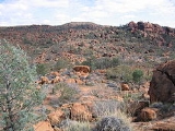
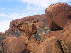
The Mawson Plateau is a 71 km² granite batholithBatholith
A batholith is a large emplacement of igneous intrusive rock that forms from cooled magma deep in the Earth's crust...
at a height of between 600 and 750m. It is dissected by Saucepan Creek and the Granite Plateau Creek; both are tributaries
Tributary
A tributary or affluent is a stream or river that flows into a main stem river or a lake. A tributary does not flow directly into a sea or ocean...
of the Hamilton Creek. The plateau
Plateau
In geology and earth science, a plateau , also called a high plain or tableland, is an area of highland, usually consisting of relatively flat terrain. A highly eroded plateau is called a dissected plateau...
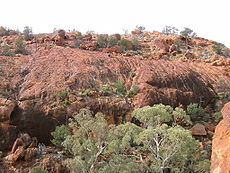
is bounded by the Hamilton Creek on the north and west, the Granite Escarpment
Escarpment
An escarpment is a steep slope or long cliff that occurs from erosion or faulting and separates two relatively level areas of differing elevations.-Description and variants:...
on the east and Freeling Heights in the south.
Place names
Douglas Mawson
Sir Douglas Mawson, OBE, FRS, FAA was an Australian geologist, Antarctic explorer and Academic. Along with Roald Amundsen, Robert Falcon Scott, and Ernest Shackleton, Mawson was a key expedition leader during the Heroic Age of Antarctic Exploration.-Early work:He was appointed geologist to an...
.
The main creek on the plateau has been known by successive owners of the Mount Freeling pastoral lease as the Granite Plateau Creek.
T Junction Waterhole appears on the Yudnamutana
Yudnamutana, South Australia
Yudnamutana is an historic mining valley in the Northern Flinders Ranges, North West of Arkaroola on the edge of the wilderness sanctuary. It is accessible by four-wheel drive from the south. Ancient mining sites give the opportunity for ecologically responsible bush camping, but no supplies are...
1:50000 topographical
Topography
Topography is the study of Earth's surface shape and features or those ofplanets, moons, and asteroids...
map and is ~100m downstream from a distinctive T-junction on Granite Plateau Creek. The waterhole is the location of an old emergency rations cache put there in the early 1980s by the owners of the Arkaroola pastoral lease.
The Granite Escarpment also appears on the Yudnamutana 1:50000 topographical map. It is a high ridge of exposed and weathered granite overlooking Lake Frome.
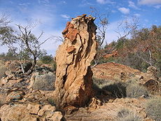
In a gorge on Granite Plateau Creek there is a high granite cliff known to bushwalkers
Hiking
Hiking is an outdoor activity which consists of walking in natural environments, often in mountainous or other scenic terrain. People often hike on hiking trails. It is such a popular activity that there are numerous hiking organizations worldwide. The health benefits of different types of hiking...
as Aqualung
Aqua-lung
Aqua-Lung was the original name of the first open-circuit free-swimming underwater breathing set in reaching worldwide popularity and commercial success...
Wall 30°5′12.5"S 139°27′51.3"E. At the base of the cliff there are permanent waterholes containing water spiders (Dolomedes spp.). The name of the cliff refers to the spider’s habit of submerging below the surface to hunt, or avoid predation, while breathing from bubbles of air attached to hairs on its abdomen.
Edmund Hill 30°6′12.4"S 139°25′17.2"E is a small peak high on the central plateau with 360-degree panoramic views of the plateau.
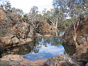
Ray's Waterhole is a picturesque permanent waterhole on Saucepan Creek.
The plateau is a remote and inaccessible wilderness
Wilderness
Wilderness or wildland is a natural environment on Earth that has not been significantly modified by human activity. It may also be defined as: "The most intact, undisturbed wild natural areas left on our planet—those last truly wild places that humans do not control and have not developed with...
and it is very unusual to find any modern human artifact
Cultural artifact
A cultural artifact is a term used in the social sciences, particularly anthropology, ethnology, and sociology for anything created by humans which gives information about the culture of its creator and users...
s on the plateau. When they are found at, or near significant locations they occasionally contribute to the place name:
Stardrop Waterhole is a permanent waterhole upstream of T Junction Waterhole and is named after the solitary steel "star dropper" fence post found at the site.
Saucepan Creek is a major tributary of the Granite Plateau Creek. The name refers to the discovery of 2 abandoned, or lost, saucepans found at different times, and at separate locations along the creek. One was found hanging from a River Red Gum
River Red Gum
The River Red Gum is a tree of the genus Eucalyptus. It is one of around 800 in the genus. It is a plantation species in many parts of the world, but is native to Australia, where it is widespread, especially beside inland water courses...
at the junction (Saucepan Junction) of Saucepan Creek and the Granite Plateau Creek 30°5′18.9"S 139°27′43.7"E, the other was found near a major waterfall on Saucepan Creek.
Climate
Australia
Australia , officially the Commonwealth of Australia, is a country in the Southern Hemisphere comprising the mainland of the Australian continent, the island of Tasmania, and numerous smaller islands in the Indian and Pacific Oceans. It is the world's sixth-largest country by total area...
major bioclimatic regions-the arid Eyrean region. Average rainfall on the adjoining pastoral lease of Arkaroola is 265 mm; however the Gammon Ranges
Vulkathunha-Gammon Ranges National Park
The Gammon Ranges are part of the northern Flinders Ranges, immediately southwest of and adjacent to Arkaroola Sanctuary. They encompass some of the most rugged and spectacular country in South Australia.-Geography:...
Rainfall Project (Maier and Wright 1996), which began monitoring rainfall on the nearby Gammon Plateau at 930m in 1988 indicated that rainfall and number of rain days increases with altitudes greater than 400m above sea level in this area. With the Mawson Plateau at ~700m, rainfall averages are likely to be higher than those at Arkaroola.
Maier and Wright found that increased rainfall at altitude was predominantly winter rainfall, however the area is strongly influenced by summer storms. The influence of these unpredictable summer storms is reflected in the differences between the highest and lowest annual rainfall records recorded at Arkaroola (56mm – 949mm). Similar variations certainly occur on the Mawson Plateau.
Aquatic habitat
Drainage basin
A drainage basin is an extent or an area of land where surface water from rain and melting snow or ice converges to a single point, usually the exit of the basin, where the waters join another waterbody, such as a river, lake, reservoir, estuary, wetland, sea, or ocean...
for the Granite Plateau Creek, and it’s major tributary Saucepan Creek. Both of these creeks flow only briefly after rain and as the region receives highly variable rainfall, water is scarce for most of the year and both creeks are ephemeral
Ephemeral
Ephemeral things are transitory, existing only briefly. Typically the term is used to describe objects found in nature, although it can describe a wide range of things....
. In places the creeks have cut deep gorges and valleys into the plateau’s granite creating permanent and semi-permanent waterholes that support numerous species of frogs including the Brown Toadlet
Bibron's Toadlet
The Bibron's Toadlet or Brown Toadlet, is a species of Australian ground-dwelling frog, that although has declined over much of its range, is widespread through most of New South Wales, Victoria, south-eastern Queensland and eastern South Australia, including Kangaroo Island.-Physical...
(Pseudophryne bibroniiand), water spiders (Dolomedes spp.) and small populations of unidentified fish. The fish are possibly Spangled Perch, (Leiopotherapon unicolor) a widely distributed desert fish common in much of the Hamilton Creek Catchment, or Lake Eyre Hardyhead, (Craterocephalus eyresii) the most common and widely distributed fish in the Flinders Ranges.
Fauna
Despite the relative abundance of permanent water, mammals and birds are sparse on the plateau, but there are small populations of EurosWallaroo
A Wallaroo is any of three closely related species of moderately large macropod, intermediate in size between the kangaroos and the wallabies. The name "wallaroo" is a portmanteau of wallaby and kangaroo. The term is not generally used by Australians...
(Macropus robustus), Echidna
Echidna
Echidnas , also known as spiny anteaters, belong to the family Tachyglossidae in the monotreme order of egg-laying mammals. There are four extant species, which, together with the platypus, are the only surviving members of that order and are the only extant mammals that lay eggs...
s (Tachyglossus aculeatusand) and a few species of bats. Feral goats are rare. Common birds include Willie Wagtail
Willie Wagtail
The Willie Wagtail is a passerine bird native to Australia, New Guinea, the Solomon Islands, the Bismarck Archipelago, and eastern Indonesia. It is a common and familiar bird throughout much of its range, living in most habitats apart from thick forest...
(Rhipidura leucophrys), Wedge-tailed Eagle
Wedge-tailed Eagle
The Wedge-tailed Eagle , sometimes known as the Eaglehawk in its native range, is the largest bird of prey in Australia, but it is also found in southern New Guinea. It has long, fairly broad wings, fully feathered legs, and an unmistakable wedge-shaped tail...
(Aquila audax), and the Southern Boobook
Southern Boobook
The Southern Boobook , also called the Mopoke, Morepork, Ruru or Tasmanian Spotted Owl, is a small brown owl found throughout New Zealand, Tasmania, across most of mainland Australia and in Timor, southern New Guinea and nearby islands.The bird has almost 20 alternative common names, most of which...
(Ninox novaeseelandiae).
Reptiles have fared better than mammals and there are numerous species of snakes, skinks and dragons.