
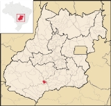
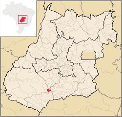
Maurilândia
Encyclopedia
| Maurilândia | |
|---|---|
| State | Goiás Goiás Goiás is a state of Brazil, located in the central part of the country. The name Goiás comes from the name of an indigenous community... |
| Area: | 393.7 km² |
| Population: | 10,769(IBGE 2007) |
| Population density | 27.35 inhab/km² |
| Urban population | 10,309 |
| Rural population | 460 |
| Elevation: | 450m |
| Postcode (CEP): | 75930-000 |
| IBGE statistical microregion: | 018 Sudoeste de Goiás Microregion |
| Became a city: | 1963 |
| Mayor: | Edjane Alves de Almeida Resende |
| Distance to Goiânia Goiânia -Climate:The city has a tropical wet and dry climate with an average temperature of . There's a wet season, from October to April, and a dry one, from May to September. Annual rainfall is around 1,520 mm.... : |
237 km. |
| Website: | |
Town
A town is a human settlement larger than a village but smaller than a city. The size a settlement must be in order to be called a "town" varies considerably in different parts of the world, so that, for example, many American "small towns" seem to British people to be no more than villages, while...
and municipality
Municipality
A municipality is essentially an urban administrative division having corporate status and usually powers of self-government. It can also be used to mean the governing body of a municipality. A municipality is a general-purpose administrative subdivision, as opposed to a special-purpose district...
in southwest Goiás
Goiás
Goiás is a state of Brazil, located in the central part of the country. The name Goiás comes from the name of an indigenous community...
state, Brazil
Brazil
Brazil , officially the Federative Republic of Brazil , is the largest country in South America. It is the world's fifth largest country, both by geographical area and by population with over 192 million people...
. It is a large producer of sugarcane.
Location
Maurilândia is located in the Southwest Goiás MicroregionSouthwest Goiás Microregion
Sudoeste de Goiás Microregion is a region in southwest Goiás state, Brazil. It includes 18 municipalities with a population of 397,387 in a total area of 56,293.30 km² . The population density was 7.06 inhabitants/km² . The largest towns are Jataí, Santa Helena de Goiás, and Rio Verde...
on the Rio São Tomé near the Rio Turvo and the Rio dos Bois, an important tributary of the Paranaíba
Paranaíba River
The Paranaíba River is a Brazilian river whose source lies in the state of Minas Gerais in the Mata da Corda mountains, municipality of Rio Paranaíba, at an altitude of 1,148 meters; on the other face of this mountain chain are the sources of the Abaeté river, tributary of the São Francisco River...
. It is 13 kilometers south of Turvelândia and 71 kilometers east of regional center Rio Verde
Rio Verde
Rio Verde can mean the following:-Brazil:* Rio Verde, Goiás* Lucas do Rio Verde* Conceição do Rio Verde* Rio Verde de Mato Grosso-Brazil:29 rivers including:* Verde River...
. The region is very ferile and has become one of the most important economic areas of the state of Goiás
Goiás
Goiás is a state of Brazil, located in the central part of the country. The name Goiás comes from the name of an indigenous community...
producing cattle, soybeans, rice, and corn. Neighboring municipalities are:
- north: TurvelândiaTurvelândiaTurvelândia is a small town and municipality in eastern Goiás state, Brazil.-Location:Turvelândia is located 65 km. east of Rio Verde*Highway connections from Goiânia are made by state highway BR-060 west from Goiânia, through / Abadia de Goiás / Guapó / Indiara / Acreúna/ GO-164 / Santa Helena...
and PorteirãoPorteirãoPorteirão is a small town and municipality in south Goiás state, Brazil.-Geographical Information:Porteirão is located in the Meia Ponte Microregion in the Rio dos Bois basin. It is connected by a state highway with the BR-452 highway, which connects Rio Verde with Itumbiara.The distance to the... - south: CastelândiaCastelândiaright|250pxCastelândia is a small town and municipality in southwest Goiás state, Brazil. It is a large producer of sugar cane and soybeans.-Location:...
- east: São DomingosSão DomingosSão Domingos can refer to many places in the world:*In Brazil:**São Domingos, Bahia**São Domingos, Goiás**São Domingos, Santa Catarina**São Domingos, Sergipe**São Domingos do Araguaia, Pará**São Domingos do Azeitão, Maranhão...
- west: Rio VerdeRio VerdeRio Verde can mean the following:-Brazil:* Rio Verde, Goiás* Lucas do Rio Verde* Conceição do Rio Verde* Rio Verde de Mato Grosso-Brazil:29 rivers including:* Verde River...
Maurilândia is 251 kilometers from the state capital, Goiânia
Goiânia
-Climate:The city has a tropical wet and dry climate with an average temperature of . There's a wet season, from October to April, and a dry one, from May to September. Annual rainfall is around 1,520 mm....
. Highway connections are made by BR-060 / Abadia de Goiás
Abadia de Goiás
Abadia de Goiás is a small town and municipality in central Goiás state, Brazil, located on the western edge of the Goiânia metropolitan area.-Geographical Data:The distance to Goiânia is 27 km...
/ Indiara
Indiara
Indiara is a small city and municipality in central-south Goiás state, Brazil. Indiara is a large producer of soybeans and cotton.-Location:Indiara is located in the Vale do Rio dos Bois and has municipal boundaries with:*north: Palmeiras de Goiás...
/ Acreúna
Acreúna
Acreúna is a small city and municipality in western Goiás state, Brazil.-Location:Acreúna is located in the statistical micro-region of Vale do Rio dos Bois, southwest of the state capital, Goiânia, on BR-060, which links Goiânia with Rio Verde...
/ GO-164 / BR-452 / GO-409.
History
Maurilândia began in 1946 when gold and diamond seekers arrived in the region, which belonged to the municipality of Rio VerdeRio Verde, Goiás
Rio Verde is a city and municipality in the Brazilian state of Goiás. It is a fast-growing center and is the largest producer of grains in the state.-Location:...
. A mining site (garimpo) was established at the meeting of the Ribeirão Cabeleira and the Rio Verdão. Soon many families arrived building straw huts. In 1954 Josias Lula, from Bahia, began to divide and sell lots with the help of local ranch owners. In 1955 the settlement took the name "Garimpo do Rio Verdão". In 1959 it became a district of Rio Verde. In 1963 it became a municipality with the name of Maurilândia. The origin of this name was not available on the Sepin site on 08/04/2008.
Economy
The economy is based on agriculture, cattle raising, services, and modest transformation industries. There is significant production of poultry. In 2006 there were 08 industrial units and 114 retail units. There were 2 bank branches: Banco do Brasil S.A and Banco Itaú S.A. Public administration was the biggest employer in 2005 with 241 workers, followed by commerce with 225 workers, and by agriculture with 134 workers.There were 18,200 head of cattle and 374,200 head of poultry registered in 2006. There was a significant production of sugarcane with 9,000 hectares planted and a production of 820,000 tons in 2006. Other important crops were corn and soybeans. Sepin. There were 120 agricultural units in 2006 with 15,000 hectares, of which 9,000 hectares were cultivated, and the rest natural pasture or woodlands.
Health and Education
In 2007 there was 1 hospital with 18 beds and 1 walk-in health clinic. The infant mortality rate was 23.82 in every 1,000 live births in 2000.In 2005 the school system had 6 schools with 3,074 students. There were no institutions of higher learning. The adult literacy rate was 81.6% in 2000. Sepin
Ranking on the Municipal Human Development Index
Human Development Index
The Human Development Index is a composite statistic used to rank countries by level of "human development" and separate "very high human development", "high human development", "medium human development", and "low human development" countries...
- MHDI: 0.726
- State ranking: 159 (out of 242 municipalities in 2000)
- National ranking: 2.508 (out of 5,507 municipalities in 2000)
Data from 2000
For the complete list see Frigoletto.com