
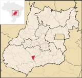
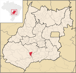
Turvelândia
Encyclopedia
| Turvelândia | |
|---|---|
| State | Goiás Goiás Goiás is a state of Brazil, located in the central part of the country. The name Goiás comes from the name of an indigenous community... |
| Area: | 934.2 km² |
| Population: | 3,852 (IBGE 2007) |
| Elevation: | 459m above sea level |
| Postcode (CEP): | 75970-000 |
| IBGE statistical microregion: | 014 Vale do Rio dos Bois |
| Became a city: | 1989 |
| Distance to Goiânia Goiânia -Climate:The city has a tropical wet and dry climate with an average temperature of . There's a wet season, from October to April, and a dry one, from May to September. Annual rainfall is around 1,520 mm.... : |
271 km. |
| Website: | none |
Town
A town is a human settlement larger than a village but smaller than a city. The size a settlement must be in order to be called a "town" varies considerably in different parts of the world, so that, for example, many American "small towns" seem to British people to be no more than villages, while...
and municipality
Municipality
A municipality is essentially an urban administrative division having corporate status and usually powers of self-government. It can also be used to mean the governing body of a municipality. A municipality is a general-purpose administrative subdivision, as opposed to a special-purpose district...
in eastern Goiás
Goiás
Goiás is a state of Brazil, located in the central part of the country. The name Goiás comes from the name of an indigenous community...
state, Brazil
Brazil
Brazil , officially the Federative Republic of Brazil , is the largest country in South America. It is the world's fifth largest country, both by geographical area and by population with over 192 million people...
.
Location
Turvelândia is located 65 km. east of Rio VerdeRio Verde, Goiás
Rio Verde is a city and municipality in the Brazilian state of Goiás. It is a fast-growing center and is the largest producer of grains in the state.-Location:...
- Highway connections from GoiâniaGoiânia-Climate:The city has a tropical wet and dry climate with an average temperature of . There's a wet season, from October to April, and a dry one, from May to September. Annual rainfall is around 1,520 mm....
are made by state highway BR-060 west from GoiâniaGoiânia-Climate:The city has a tropical wet and dry climate with an average temperature of . There's a wet season, from October to April, and a dry one, from May to September. Annual rainfall is around 1,520 mm....
, through / Abadia de GoiásAbadia de GoiásAbadia de Goiás is a small town and municipality in central Goiás state, Brazil, located on the western edge of the Goiânia metropolitan area.-Geographical Data:The distance to Goiânia is 27 km...
/ GuapóGuapóGuapó is a small town and municipality in central Goiás state, Brazil. The population was 13,586 and the total area of the municipality was 517.0 km² .Guapó is part of the Goiânia Microregion...
/ IndiaraIndiaraIndiara is a small city and municipality in central-south Goiás state, Brazil. Indiara is a large producer of soybeans and cotton.-Location:Indiara is located in the Vale do Rio dos Bois and has municipal boundaries with:*north: Palmeiras de Goiás...
/ AcreúnaAcreúnaAcreúna is a small city and municipality in western Goiás state, Brazil.-Location:Acreúna is located in the statistical micro-region of Vale do Rio dos Bois, southwest of the state capital, Goiânia, on BR-060, which links Goiânia with Rio Verde...
/ GO-164 / Santa Helena de GoiásSanta Helena de GoiásSanta Helena de Goiás is a small city and municipality in southwestern Goiás state, Brazil. It is a large producer of corn, sugarcane, soybeans, and poultry.-Location:...
/ BR-452 / GO-409 / MaurilândiaMaurilândiathumb|right|250px|Coordinates: Maurilândia is a small town and municipality in southwest Goiás state, Brazil. It is a large producer of sugarcane.-Location:...
.
Neighboring municipalities: Acreúna
Acreúna
Acreúna is a small city and municipality in western Goiás state, Brazil.-Location:Acreúna is located in the statistical micro-region of Vale do Rio dos Bois, southwest of the state capital, Goiânia, on BR-060, which links Goiânia with Rio Verde...
, Edéia
Edéia
Edéia is a small city and municipality in south-central Goiás state, Brazil.-Municipal Boundaries:Edéia is in the Vale do Rio dos Boisstatistical micro-region and has municipal boundaries with:*north: Indiara*west: Acreúna and Turvelândia...
, Santa Helena de Goiás
Santa Helena de Goiás
Santa Helena de Goiás is a small city and municipality in southwestern Goiás state, Brazil. It is a large producer of corn, sugarcane, soybeans, and poultry.-Location:...
, Maurilândia
Maurilândia
thumb|right|250px|Coordinates: Maurilândia is a small town and municipality in southwest Goiás state, Brazil. It is a large producer of sugarcane.-Location:...
Political Information
- Mayor: Eduardo Mendonça (January 2005)
- City council: 09 members
- Eligible voters: 3,348 (December/2007)
Demographic Information
- Population density: 4.1 inhab/km² (2007)
- Urban population: 2,865 (2007)
- Rural population: 987 (2007)
- Population growth: a loss of about 1,800 people since 1991
Economic Information
The economy is based on subsistence agriculture, cattle raising, services, public administration, and small transformation industries.Public administration provided jobs for 238 workers in 2003.
- Industrial units: 3 (2007)
- Commercial units: 32 (2007)
- Destillary: Vale do Verdão S/A (2007)
- Motor vehicles: 233 (2007), which gave a ratio of 16 inhabitants for each motor vehicle
- Cattle herd: 45,000 head (3,600 milk cows) (2006)
- Main crops: cotton, rice, sugarcane (11,200 hectares), manioc, corn (3,000 hectares), sorghum, and soybeans (14,000 hectares).
Education (2006)
- Schools: 4 with 1,075 studens
- Higher education: none
- Adult literacy rate: 79.6% (2000) (national average was 86.4%)
Health (2007)
- Hospitals: 1
- Hospital beds: 13
- Ambulatory clinics: 3
- Infant mortality rate: 38.71 (2000) (national average was 33.0)
Municipal Human Development IndexHuman Development IndexThe Human Development Index is a composite statistic used to rank countries by level of "human development" and separate "very high human development", "high human development", "medium human development", and "low human development" countries...
- MHDI: 0.685
- State ranking: 220 (out of 242 municipalities in 2000)
- National ranking: 3,223 (out of 5,507 municipalities in 2000)
Data are from 2000
For the complete list see Frigoletto.com