
Matheysine
Encyclopedia
Matheysine is a French Natural region
located in the Alps
at the south of the Isère
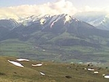
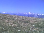
département. Its relief is a plateau
surroundered by mountains. Matheysine is also called Plateau Matheysin.

département, 30 km south of Grenoble
when heading to Gap
. Included in the overall Taillefer massif, its average elevation is 1,000 m.
 Belonging to south-Dauphiné
, it is crossed over by the 45th parallel north and roughly matches the boundaries of the canton of La Mure
. It is around 20 km long from north to south and around 13 km wide from east to west. At the south and at the west, the border of the plateau is marked by the Drac River
, which defines the boundary with Trièves (at the south) and with the Vercors Plateau
(at the west). At the north, the plateau ends at the Laffrey
slope down to the Romanche
valley at the elevation of 350m. At the east, the small mountain range including the summits of Grand Serre (elev. 2,141m.) and Tabor (elev. 2,389m.) marks the boundary with the Valbonnais canton.
Beside these mountains, the plateau is crossed over from north to south by the summits of the Connest Mountain (Peyrouse, Connex) and of the Sénépy
. These mountains overlook a succession of four lakes of glacier
origin called the Laffrey lakes. From north to south, these lakes are composed of the lac Mort, the Grand lac de Laffrey
, the Petichet lake, the Pierre-Châtel lake. Close to the Pierre-Châtel lake can be found one of the so-called Seven Wonders of Dauphiné, a natural arch called the Pierre Percée
.
La Mure
is Matheysine's main city.
s during the previous glacial period
s and surrounded by high mountain ranges, the bise
wind blows intensely, being frosty during Winter, but pleasant in Summer.
Furthermore, at Winter time, the area can face heavy snowfalls.
For these reasons, Matheysine is being nicknamed Little Siberia.
Matheysine's people are called Matheysins.
, after having landed at Juan-les-Pins
when coming back from Elba
, crosses Matheysine. There, in a prairie located along the shore of Grand lac de Laffrey
, at the place now called Prairie de la Rencontre (Meeting Prairie), the emperor and his troops (1,100 men led by 3 generals) met the royal army sent in order to stop them. Napoléon succeeded in rallying his opponents to his cause and could finally make it forward to Grenoble
.
An equestrian statue of Napoléon still reminds this event.
. This coal, of superior quality (anthracite), had been extracted starting at the beginning of the 19th century until the late 1990s. It has highly contributed to the reputation of the plateau.
activity on the plateau.
New industries installations have been favoured through aids and fiscal easy terms. Tourism
, as well as local craft industry, also help at renewing Matheysine's economic health.
Furthermore, the area presently experiences the arrival of urban people from the Grenoble
built-up area, looking for more affordable real estate costs whilst keeping on working downtown. This phenomenon is partly contributing to a revival of the local trade.
Natural region
A Natural region is one which is distinguished by its natural features of geography and usually more important, geology. The natural ecology of the region is likely to be significant but one of these factors tends to influence the others....
located in the Alps
Alps
The Alps is one of the great mountain range systems of Europe, stretching from Austria and Slovenia in the east through Italy, Switzerland, Liechtenstein and Germany to France in the west....
at the south of the Isère
Isère
Isère is a department in the Rhône-Alpes region in the east of France named after the river Isère.- History :Isère is one of the original 83 departments created during the French Revolution on March 4, 1790. It was created from part of the former province of Dauphiné...
département. Its relief is a plateau
Plateau
In geology and earth science, a plateau , also called a high plain or tableland, is an area of highland, usually consisting of relatively flat terrain. A highly eroded plateau is called a dissected plateau...
surroundered by mountains. Matheysine is also called Plateau Matheysin.
Geography
The Plateau Matheysin is located in the IsèreIsère
Isère is a department in the Rhône-Alpes region in the east of France named after the river Isère.- History :Isère is one of the original 83 departments created during the French Revolution on March 4, 1790. It was created from part of the former province of Dauphiné...
département, 30 km south of Grenoble
Grenoble
Grenoble is a city in southeastern France, at the foot of the French Alps where the river Drac joins the Isère. Located in the Rhône-Alpes region, Grenoble is the capital of the department of Isère...
when heading to Gap
Gap, Hautes-Alpes
Gap is a commune in southeastern France, the capital of the Hautes-Alpes department.-Geography:An Alpine crossroads at the intersection of D994 and Route nationale 85 the Route Napoléon, Gap lies above sea level along the right bank of the Luye River...
. Included in the overall Taillefer massif, its average elevation is 1,000 m.
Dauphiné
The Dauphiné or Dauphiné Viennois is a former province in southeastern France, whose area roughly corresponded to that of the present departments of :Isère, :Drôme, and :Hautes-Alpes....
, it is crossed over by the 45th parallel north and roughly matches the boundaries of the canton of La Mure
Canton of La Mure
Canton of La Mure is a canton of the Isère département, in south-eastern part of France.Main city: La MureOther communes:* Cholonge* Cognet* Marcieu* Mayres-Savel* Monteynard* la Motte-d'Aveillans* la Motte-Saint-Martin...
. It is around 20 km long from north to south and around 13 km wide from east to west. At the south and at the west, the border of the plateau is marked by the Drac River
Drac River
The Drac is a 130 km long river in southeastern France, left tributary of the Isère. It is formed by the confluence of the Drac Noir and the Drac Blanc, that both rise in the southern part of the Massif des Écrins. It flows through several reservoirs, including the Lac de Monteynard-Avignonet....
, which defines the boundary with Trièves (at the south) and with the Vercors Plateau
Vercors Plateau
The Vercors is a range of plateaux and mountains in the départements of Isère and Drôme in the French Prealps. It lies west of the Dauphiné Alps, from which it is separated by the rivers Drac and Isère...
(at the west). At the north, the plateau ends at the Laffrey
Laffrey
Laffrey is a commune in the Isère department in south-eastern France.- See also :* Communes of the Isère department* Rampe de Laffrey* Grand lac de Laffrey* Route Napoléon...
slope down to the Romanche
Romanche
The Romanche is a 78 km long mountain river in southeastern France, right tributary of the Drac . Its source is in the northern part of the Massif des Écrins, Dauphiné Alps. It flows into the Drac in Champ-sur-Drac, south of Grenoble. The road from Grenoble to Briançon over the Col du Lautaret runs...
valley at the elevation of 350m. At the east, the small mountain range including the summits of Grand Serre (elev. 2,141m.) and Tabor (elev. 2,389m.) marks the boundary with the Valbonnais canton.
Beside these mountains, the plateau is crossed over from north to south by the summits of the Connest Mountain (Peyrouse, Connex) and of the Sénépy
Sénépy
Sénépy is a mountain located in Matheysine, in the Dauphiné Alps of south-eastern France.Its elevation is 1,769m. It overlooks the Drac River valley, the Monteynard lake, as well as the Trièves plateau on the opposite riverbank....
. These mountains overlook a succession of four lakes of glacier
Glacier
A glacier is a large persistent body of ice that forms where the accumulation of snow exceeds its ablation over many years, often centuries. At least 0.1 km² in area and 50 m thick, but often much larger, a glacier slowly deforms and flows due to stresses induced by its weight...
origin called the Laffrey lakes. From north to south, these lakes are composed of the lac Mort, the Grand lac de Laffrey
Grand lac de Laffrey
The Grand lac de Laffrey is one of the Laffrey lakes, located in Matheysine at 23 km south of Grenoble, in the Isère département....
, the Petichet lake, the Pierre-Châtel lake. Close to the Pierre-Châtel lake can be found one of the so-called Seven Wonders of Dauphiné, a natural arch called the Pierre Percée
Pierre Percée
The Pierre Percée is a natural arch located on a hill of Matheysine, in the Isère département, upon the commune of Pierre-Châtel. It belongs to the so-called Seven Wonders of Dauphiné.Internal gap is 3m. high....
.
La Mure
La Mure
La Mure is a commune in the Isère département in south-eastern France.It is located south of Grenoble on the plateau Matheysin.-Neighbour communes:* Prunières* Sousville* Susville* Ponsonnas* Pierre-Châtel* Saint-Honoré-Main sights:...
is Matheysine's main city.
Climate
On this plateau, shaped by glacierGlacier
A glacier is a large persistent body of ice that forms where the accumulation of snow exceeds its ablation over many years, often centuries. At least 0.1 km² in area and 50 m thick, but often much larger, a glacier slowly deforms and flows due to stresses induced by its weight...
s during the previous glacial period
Glacial period
A glacial period is an interval of time within an ice age that is marked by colder temperatures and glacier advances. Interglacials, on the other hand, are periods of warmer climate within an ice age...
s and surrounded by high mountain ranges, the bise
Bise
-Switzerland:In Switzerland the bise blows from the north-east, above all during the winter months, and is due to a high-pressure cell north-west of Switzerland. The effects of the bise are strongest in Geneva, situated in a narrow passage between the Jura mountains in the West and the Alps in the...
wind blows intensely, being frosty during Winter, but pleasant in Summer.
Furthermore, at Winter time, the area can face heavy snowfalls.
For these reasons, Matheysine is being nicknamed Little Siberia.
Etymology
Have been successively used the names Mathaysana (11th century) and later Mattacena (14th century), which could possibly mean Matta "to be wet" and Cena "plateau". This depicts actually rather well both geography and climatic characteristics of the place. At last, before present name, Mataisine has also been used.Matheysine's people are called Matheysins.
Napoléon I in Matheysine
The alpine road used by emperor Napoléon INapoleon I of France
Napoleon Bonaparte was a French military and political leader during the latter stages of the French Revolution.As Napoleon I, he was Emperor of the French from 1804 to 1815...
, after having landed at Juan-les-Pins
Juan-les-Pins
Juan-les-PinsCountry:Region:Department: Alpes-MaritimesArrondissement: GrasseCanton: Vallauris-Antibes-OuestMunicipality: AntibesPopulation:?Coordinates:Time zone:CET, UTC+1Elevation:10 amslPostal code:06600...
when coming back from Elba
Elba
Elba is a Mediterranean island in Tuscany, Italy, from the coastal town of Piombino. The largest island of the Tuscan Archipelago, Elba is also part of the National Park of the Tuscan Archipelago and the third largest island in Italy after Sicily and Sardinia...
, crosses Matheysine. There, in a prairie located along the shore of Grand lac de Laffrey
Grand lac de Laffrey
The Grand lac de Laffrey is one of the Laffrey lakes, located in Matheysine at 23 km south of Grenoble, in the Isère département....
, at the place now called Prairie de la Rencontre (Meeting Prairie), the emperor and his troops (1,100 men led by 3 generals) met the royal army sent in order to stop them. Napoléon succeeded in rallying his opponents to his cause and could finally make it forward to Grenoble
Grenoble
Grenoble is a city in southeastern France, at the foot of the French Alps where the river Drac joins the Isère. Located in the Rhône-Alpes region, Grenoble is the capital of the department of Isère...
.
An equestrian statue of Napoléon still reminds this event.
Coal mining
History of Matheysine has been strongly impacted by coalCoal
Coal is a combustible black or brownish-black sedimentary rock usually occurring in rock strata in layers or veins called coal beds or coal seams. The harder forms, such as anthracite coal, can be regarded as metamorphic rock because of later exposure to elevated temperature and pressure...
. This coal, of superior quality (anthracite), had been extracted starting at the beginning of the 19th century until the late 1990s. It has highly contributed to the reputation of the plateau.
Economic characteristics
Matheysine has been going through an economic reconversion since the planned decline and the cessation of the coal miningCoal mining
The goal of coal mining is to obtain coal from the ground. Coal is valued for its energy content, and since the 1880s has been widely used to generate electricity. Steel and cement industries use coal as a fuel for extraction of iron from iron ore and for cement production. In the United States,...
activity on the plateau.
New industries installations have been favoured through aids and fiscal easy terms. Tourism
Tourism
Tourism is travel for recreational, leisure or business purposes. The World Tourism Organization defines tourists as people "traveling to and staying in places outside their usual environment for not more than one consecutive year for leisure, business and other purposes".Tourism has become a...
, as well as local craft industry, also help at renewing Matheysine's economic health.
Furthermore, the area presently experiences the arrival of urban people from the Grenoble
Grenoble
Grenoble is a city in southeastern France, at the foot of the French Alps where the river Drac joins the Isère. Located in the Rhône-Alpes region, Grenoble is the capital of the department of Isère...
built-up area, looking for more affordable real estate costs whilst keeping on working downtown. This phenomenon is partly contributing to a revival of the local trade.
External links
See also
- Dauphiné AlpsDauphiné AlpsThe Dauphiné Alps are a group of mountain ranges in southeastern France, west of the main chain of the Alps. They are separated from the Cottian Alps in the east by the Col du Galibier and the upper Durance valley; from the western Graian Alps in the north-east by the river Arc; from the lower...