
Maryland Route 542
Encyclopedia
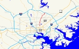
Maryland Route 542 is a state highway
in the U.S. state of Maryland
. Known for most of its length as Loch Raven Boulevard, the state highway runs 6.33 miles (10.2 km) from MD 147
in Baltimore north to Interstate 695
(I-695) and Cromwell Bridge Road
near Towson
. MD 542 is a four-lane divided highway that connects portions of Northeast Baltimore with Towson and I-695. The state highway is maintained by the Maryland State Highway Administration
in Baltimore County
and the Baltimore City Department of Transportation in the city. MD 542 was constructed in the early to mid-1930s. The highway was expanded to a divided highway in Baltimore by 1950 and in Baltimore County
in the mid- to late 1950s.
in Baltimore. St. Lo Drive heads south into the city park on the south side of the intersection. The state highway heads north as The Alameda, a four-lane divided boulevard through the Coldstream-Homestead-Montebello
neighborhood, where the highway passes Baltimore City College
. North of 33rd Street, MD 542 heads through the Ednor Gardens-Lakeside
neighborhood north to Loch Raven Boulevard. MD 542 switches to Loch Raven Boulevard while The Alameda continues through the Northwood
neighborhood. The state highway intersects Cold Spring Lane and crosses Chinquapin Run. North of Good Samaritan Hospital
, MD 542 intersects Northern Parkway and leaves the city limits.
MD 542 meets the northern end of Hillen Road shortly after entering Baltimore County on the eastern edge of Towson. The state highway's northbound direction gains a third lane north to Taylor Avenue, where the highway veers northeast. MD 542 intersects Putty Hill Avenue and Joppa Road before reaching I-695 (Baltimore Beltway). The state highway passes under the Beltway and has ramps from eastbound I-695 to southbound MD 542 and from northbound MD 542 to eastbound I-695. MD 542 curves northwest and reaches its northern terminus at Cromwell Bridge Road. The northwest leg of the terminal intersection comprises ramps to and from westbound I-695.
!County
!Location
!Mile
!Destinations
!Notes
|-
|rowspan=5 colspan=2|Baltimore City
|0.00
|
|Southern terminus
|
|-
|0.56
|33rd Street
|
|-
|0.96
|Loch Raven Boulevard south / The Alameda north
|MD 542 veers north onto Loch Raven Boulevard
|-
|1.81
|Cold Spring Lane
|
|-
|3.25
|Northern Parkway
|
|-
|rowspan=3|Baltimore
|rowspan=3|Towson
|5.89
|Joppa Road
|
|-
|6.21
|
|I-695 Exit 29; eastbound exit and entrance from I-695
|-
|6.33
|
|Northern terminus; I-695 Exit 29
State highway
State highway, state road or state route can refer to one of three related concepts, two of them related to a state or provincial government in a country that is divided into states or provinces :#A...
in the U.S. state of Maryland
Maryland
Maryland is a U.S. state located in the Mid Atlantic region of the United States, bordering Virginia, West Virginia, and the District of Columbia to its south and west; Pennsylvania to its north; and Delaware to its east...
. Known for most of its length as Loch Raven Boulevard, the state highway runs 6.33 miles (10.2 km) from MD 147
Maryland Route 147
Maryland Route 147 is a state highway in the U.S. state of Maryland. Known as Harford Road, the state highway runs from U.S. Route 1 in Baltimore north to US 1 and US 1 Business in Benson. MD 147 is an alternate route to US 1 between Baltimore and Bel Air, the county seat of Harford County...
in Baltimore north to Interstate 695
Interstate 695 (Maryland)
Interstate 695 is a -long full beltway Interstate Highway extending around Baltimore, Maryland, USA. I-695 is officially designated the McKeldin Beltway, but is colloquially referred to as either the Baltimore Beltway or 695...
(I-695) and Cromwell Bridge Road
Cromwell Bridge Road
Cromwell Bridge Road, formerly Maryland Route 567, is a two-lane roadway in the Towson, Maryland, area of the United States. The road begins at Providence Road in Towson, and continues past the Baltimore Beltway for several miles to its end, where it splits, a left turn going onto Glen Arm Road and...
near Towson
Towson, Maryland
Towson is an unincorporated community and a census-designated place in Baltimore County, Maryland, United States. The population was 55,197 at the 2010 census...
. MD 542 is a four-lane divided highway that connects portions of Northeast Baltimore with Towson and I-695. The state highway is maintained by the Maryland State Highway Administration
Maryland State Highway Administration
The Maryland State Highway Administration is the state agency responsible for maintaining Maryland numbered highways outside of Baltimore City...
in Baltimore County
Baltimore County, Maryland
Baltimore County is a county located in the northern part of the US state of Maryland. In 2010, its population was 805,029. It is part of the Baltimore-Washington Metropolitan Area. Its county seat is Towson. The name of the county was derived from the barony of the Proprietor of the Maryland...
and the Baltimore City Department of Transportation in the city. MD 542 was constructed in the early to mid-1930s. The highway was expanded to a divided highway in Baltimore by 1950 and in Baltimore County
Baltimore County, Maryland
Baltimore County is a county located in the northern part of the US state of Maryland. In 2010, its population was 805,029. It is part of the Baltimore-Washington Metropolitan Area. Its county seat is Towson. The name of the county was derived from the barony of the Proprietor of the Maryland...
in the mid- to late 1950s.
Route description
MD 542 begins at an intersection with MD 147 (Harford Road) adjacent to Clifton ParkClifton Park, Baltimore
Clifton Park is a public urban park located in the Belair-Edison neighborhood in the northeast section of Baltimore, Maryland. USA. It is roughly bordered by Erdman Avenue to the northeast, Sinclair Lane to the south, Harford Road to the northwest and Belair Road to the southeast...
in Baltimore. St. Lo Drive heads south into the city park on the south side of the intersection. The state highway heads north as The Alameda, a four-lane divided boulevard through the Coldstream-Homestead-Montebello
Coldstream-Homestead-Montebello, Baltimore
The Coldstream-Homestead-Montebello community, aka CHUM, located in the northeastern section of Baltimore City, Maryland, is bounded by Harford Road on the east; Loch Raven Boulevard on the west; 25th Street on the south; and 32nd and 33rd Street on the north and includes Baltimore's scenic Lake...
neighborhood, where the highway passes Baltimore City College
Baltimore City College
The Baltimore City College , also referred to as The Castle on the Hill, historically as The College, and most commonly City, is a public high school in Baltimore, Maryland, U.S.A. The City College curriculum includes the International Baccalaureate Programme and emphasizes study in the classics...
. North of 33rd Street, MD 542 heads through the Ednor Gardens-Lakeside
Ednor Gardens-Lakeside, Baltimore
Ednor Gardens-Lakeside is a large community in northeast Baltimore, Maryland. Its bounded on the south by 33rd street and the east by Lake Montebello. The community association is named the Ednor Gardens-Lakeside Community Association. The homes range from large single family homes to...
neighborhood north to Loch Raven Boulevard. MD 542 switches to Loch Raven Boulevard while The Alameda continues through the Northwood
Northwood, Baltimore
Northwood is a neighborhood in the northeastern section of Baltimore, Maryland in the United States. Northwood is served by the New Northwood and the Original Northwood community associations. The area is also home to the Northwood Shopping Center and the Northwood Baseball League...
neighborhood. The state highway intersects Cold Spring Lane and crosses Chinquapin Run. North of Good Samaritan Hospital
Good Samaritan Hospital (Baltimore)
Good Samaritan Hospital is a hospital in Baltimore. It is located at the corner of Loch Raven Boulevard and East Belvedere Avenue.U.S. News and World Report has named the hospital in its Top 50 for Orthopedics, Diabetes care and geriatrics....
, MD 542 intersects Northern Parkway and leaves the city limits.
MD 542 meets the northern end of Hillen Road shortly after entering Baltimore County on the eastern edge of Towson. The state highway's northbound direction gains a third lane north to Taylor Avenue, where the highway veers northeast. MD 542 intersects Putty Hill Avenue and Joppa Road before reaching I-695 (Baltimore Beltway). The state highway passes under the Beltway and has ramps from eastbound I-695 to southbound MD 542 and from northbound MD 542 to eastbound I-695. MD 542 curves northwest and reaches its northern terminus at Cromwell Bridge Road. The northwest leg of the terminal intersection comprises ramps to and from westbound I-695.
History
Loch Raven Boulevard was constructed around 1933 from 33rd Street to Hillen Road just north of the city limits. MD 542 was extended north in three sections in 1934 and 1935. The first section was an upgrade of Hillen Road north to what is now Goucher Boulevard. The second and third sections were new construction north to Taylor Avenue and Joppa Road, respectively. By 1950, Loch Raven Boulevard was extended north to its present terminus at Cromwell Bridge Road and expanded to a divided highway from MD 147 to Hillen Road. MD 542 was expanded to a divided highway from Hillen Road to Joppa Road between 1954 and 1956. The state highway was widened to a four-lane divided highway from Joppa Road to Cromwell Bridge Road concurrent with the completion of the Baltimore Beltway from York Road to Cromwell Bridge Road in 1958. The ramps to eastbound I-695 were added when the freeway was completed from Cromwell Bridge Road to Belair Road in 1962.Junction list
{| class=wikitable!County
!Location
!Mile
!Destinations
!Notes
|-
|rowspan=5 colspan=2|Baltimore City
|0.00
|
|Southern terminus
|
|-
|0.56
|33rd Street
|
|-
|0.96
|Loch Raven Boulevard south / The Alameda north
|MD 542 veers north onto Loch Raven Boulevard
|-
|1.81
|Cold Spring Lane
|
|-
|3.25
|Northern Parkway
|
|-
|rowspan=3|Baltimore
Baltimore County, Maryland
Baltimore County is a county located in the northern part of the US state of Maryland. In 2010, its population was 805,029. It is part of the Baltimore-Washington Metropolitan Area. Its county seat is Towson. The name of the county was derived from the barony of the Proprietor of the Maryland...
|rowspan=3|Towson
Towson, Maryland
Towson is an unincorporated community and a census-designated place in Baltimore County, Maryland, United States. The population was 55,197 at the 2010 census...
|5.89
|Joppa Road
|
|-
|6.21
|
|I-695 Exit 29; eastbound exit and entrance from I-695
|-
|6.33
|
|Northern terminus; I-695 Exit 29