
Maryland Route 413
Encyclopedia
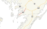
Maryland Route 413 is a 14.61 miles (23.51 km) state highway in Somerset County
in the U.S. state
of Maryland
. The route runs from a dead end at Crisfield
's city dock, which is located on the Tangier Sound
, northeast to U.S. Route 13
in Westover
. It is the main highway leading into Crisfield, and is known as Crisfield Highway for much of its length. The highways travels through mostly rural areas of farms and woods as well as the communities of Hopewell, Marion Station
, and Kingston
. It is a two-lane undivided road for most of its length; a portion of the road in Crisfield is a four-lane road that follows a one-way pair
. MD 413 is part of two scenic routes: Blue Crab Scenic Byway and the Beach to Bay Indian Trail, the latter being a Maryland Scenic Byway.
The Crisfield–Westover Road was one of the original state roads marked for improvement by the Maryland State Roads Commission. The highway was paved in the 1910s and designated MD 413 in 1927. MD 413 was relocated starting in the late 1930s to a new alignment parallel to the Eastern Shore Railroad line that made Crisfield the "Seafood Capital of the World." The relocation began in Crisfield and was completed to Westover in 1950. The old alignment of MD 413 was designated MD 667
. The state highway was expanded to a divided highway in the mid 1950s in Crisfield. The railroad track was abandoned in 1976 and later removed, but traces of the railroad remain along MD 413's modern alignment.
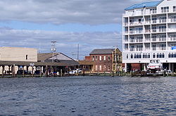 Maryland Route 413 begins at the city dock on the waterfront in Crisfield
at the intersection with Dock Street, heading to the northeast. It begins on a four-lane boulevard with a median, and is known as West Main Street, fronting local businesses in the downtown area. After Seventh Street, Main Street leaves MD 413, and the boulevard's two carriageways become known as Richardson Avenue northbound and Maryland Avenue southbound. This portion of road carries a 35 mph (56.3 km/h) speed limit. At this point the road begins to front mostly homes on Maryland Avenue, while on Richardson Avenue it runs past and homes and businesses, such as gas stations and restaurants. On a gentle curve, Chesapeake Avenue intersects the northbound carriageway, providing access to the southern beginning of Maryland Route 667
.
Before leaving the city, the route intersects Maryland Route 460
, also known as Hall Highway, immediately accessible only from the southbound carriageway. MD 460 provides a direct link to McCready Memorial Hospital. Access to that route from northbound MD 413 is given by Wynfall Avenue, which the road intersects farther south. Very soon after, it intersects Maryland Route 358
(Jacksonville Road), which heads north, and Somerset Avenue, which heads south. Past the MD 358 intersection, the road narrows to two travel lanes with the median becoming a left turn lane as many businesses and side streets front the road. The route becomes the Crisfield Highway, which it is known as for the remainder of its journey. After intersecting Silver Lane, the left turn lane closes, and MD 413 becomes a rural, two-lane highway with full shoulders, exiting Crisfield's corporate limits just north of the Rubberset entrance. It eventually reaches a speed limit of 55 mph (88.5 km/h) past the old site of Carvel Hall Cutlery.
Upon leaving Crisfield, MD 413 passes through a mix of woodland and farmland. In Hopewell, MD 667 intersects the highway, and after clearing some modest wooded development up to and slightly beyond the Holland Crossing Road intersection, the route enters heavy woodland. It passes a man-made pond before intersecting MD 667 again. Both routes parallel each other on the way into the community of Marion Station
, straddling the old railroad bed. Both routes are intersected by Davis Road and Tulls Corner Road/Charles Cannon Road, after which MD 667 turns almost due east, with MD 413 heading through a small neighborhood outside the center of Marion.
Past Marion, the route resumes northeast through woods and farms with some residences along the route. Approaching Kingston
, MD 413 intersects Lovers Lane. After this, a long curve to the north-northeast begins, which ends just south of Kingston Lane and the center of Kingston. Beyond Kingston, the route crosses the Big Annemessex River
and travels past a tree farm. After passing through a forest, two side roads lead to the Somerset County Health Department and the Somerset Intermediate School, with the pavement's striping reconfigured to accommodate left turns at the two close intersections.
As the road nears Westover
, it passes by the Great Hope Golf Course and shortly after intersects Maryland Route 361
(Fairmount Road). Here, the speed limit drops to 40 mph (64.4 km/h) before it meets Old Westover-Marion Road, a former routing of the highway. Passing through the development of Westover, MD 413 intersects Maryland Route 673 (Sam Barnes Road), a short connector route to U.S. Route 13
southbound to Pocomoke City
. From US 13 northbound, MD 673 serves as the connection to MD 413 southbound. Past MD 673, the highway passes through farmland and increases speed to 50 mph (80.5 km/h). MD 413 heads through some woods and crosses the Back Creek of the Manokin River before coming to end at an intersection with US 13.
MD 413 is part of the Blue Crab Scenic Byway, which consists of various roads in the lower Eastern Shore of Maryland. It is also part of the Beach to Bay Indian Trail, a Maryland Scenic Byway that connects Ocean City
on the Atlantic Ocean
to Smith Island
in the Chesapeake Bay
and is noted by signs along the route.
.
Maryland Route 413 (also known as MD 413 or Route 413) is a 14.61 miles (23.51 km) state highway in Somerset County
in the U.S. state
of Maryland
. The route runs from a dead end at Crisfield
's city dock, which is located on the Tangier Sound
, northeast to U.S. Route 13
in Westover
. It is the main highway leading into Crisfield, and is known as Crisfield Highway for much of its length. The highways travels through mostly rural areas of farms and woods as well as the communities of Hopewell, Marion Station
, and Kingston
. It is a two-lane undivided road for most of its length; a portion of the road in Crisfield is a four-lane road that follows a one-way pair
. MD 413 is part of two scenic routes: Blue Crab Scenic Byway and the Beach to Bay Indian Trail, the latter being a Maryland Scenic Byway.
The Crisfield–Westover Road was one of the original state roads marked for improvement by the Maryland State Roads Commission. The highway was paved in the 1910s and designated MD 413 in 1927. MD 413 was relocated starting in the late 1930s to a new alignment parallel to the Eastern Shore Railroad line that made Crisfield the "Seafood Capital of the World." The relocation began in Crisfield and was completed to Westover in 1950. The old alignment of MD 413 was designated MD 667
. The state highway was expanded to a divided highway in the mid 1950s in Crisfield. The railroad track was abandoned in 1976 and later removed, but traces of the railroad remain along MD 413's modern alignment.
Maryland Route 413 begins at the city dock on the waterfront in Crisfield
at the intersection with Dock Street, heading to the northeast. It begins on a four-lane boulevard with a median, and is known as West Main Street, fronting local businesses in the downtown area. After Seventh Street, Main Street leaves MD 413, and the boulevard's two carriageways become known as Richardson Avenue northbound and Maryland Avenue southbound. This portion of road carries a 35 mph (56.3 km/h) speed limit. At this point the road begins to front mostly homes on Maryland Avenue, while on Richardson Avenue it runs past and homes and businesses, such as gas stations and restaurants. On a gentle curve, Chesapeake Avenue intersects the northbound carriageway, providing access to the southern beginning of Maryland Route 667
.
Before leaving the city, the route intersects Maryland Route 460
, also known as Hall Highway, immediately accessible only from the southbound carriageway. MD 460 provides a direct link to McCready Memorial Hospital. Access to that route from northbound MD 413 is given by Wynfall Avenue, which the road intersects farther south. Very soon after, it intersects Maryland Route 358
(Jacksonville Road), which heads north, and Somerset Avenue, which heads south. Past the MD 358 intersection, the road narrows to two travel lanes with the median becoming a left turn lane as many businesses and side streets front the road. The route becomes the Crisfield Highway, which it is known as for the remainder of its journey. After intersecting Silver Lane, the left turn lane closes, and MD 413 becomes a rural, two-lane highway with full shoulders, exiting Crisfield's corporate limits just north of the Rubberset entrance. It eventually reaches a speed limit of 55 mph (88.5 km/h) past the old site of Carvel Hall Cutlery.
Upon leaving Crisfield, MD 413 passes through a mix of woodland and farmland. In Hopewell, MD 667 intersects the highway, and after clearing some modest wooded development up to and slightly beyond the Holland Crossing Road intersection, the route enters heavy woodland. It passes a man-made pond before intersecting MD 667 again. Both routes parallel each other on the way into the community of Marion Station
, straddling the old railroad bed. Both routes are intersected by Davis Road and Tulls Corner Road/Charles Cannon Road, after which MD 667 turns almost due east, with MD 413 heading through a small neighborhood outside the center of Marion.
Past Marion, the route resumes northeast through woods and farms with some residences along the route. Approaching Kingston
, MD 413 intersects Lovers Lane. After this, a long curve to the north-northeast begins, which ends just south of Kingston Lane and the center of Kingston. Beyond Kingston, the route crosses the Big Annemessex River
and travels past a tree farm. After passing through a forest, two side roads lead to the Somerset County Health Department and the Somerset Intermediate School, with the pavement's striping reconfigured to accommodate left turns at the two close intersections.
As the road nears Westover
, it passes by the Great Hope Golf Course and shortly after intersects Maryland Route 361
(Fairmount Road). Here, the speed limit drops to 40 mph (64.4 km/h) before it meets Old Westover-Marion Road, a former routing of the highway. Passing through the development of Westover, MD 413 intersects Maryland Route 673 (Sam Barnes Road), a short connector route to U.S. Route 13
southbound to Pocomoke City
. From US 13 northbound, MD 673 serves as the connection to MD 413 southbound. Past MD 673, the highway passes through farmland and increases speed to 50 mph (80.5 km/h). MD 413 heads through some woods and crosses the Back Creek of the Manokin River before coming to end at an intersection with US 13.
MD 413 is part of the Blue Crab Scenic Byway, which consists of various roads in the lower Eastern Shore of Maryland. It is also part of the Beach to Bay Indian Trail, a Maryland Scenic Byway that connects Ocean City
on the Atlantic Ocean
to Smith Island
in the Chesapeake Bay
and is noted by signs along the route.
. The city's importance led to the Crisfield–Westover Road being designated one of the original state roads nominated for improvement by the Maryland State Roads Commission in 1909. The state road was paved from the eastern city limits of Crisfield (the present western terminus of MD 667) to Hopewell and from Westover to Kingston in 1913. The segment between Kingston and Marion was completed in 1915. The state road was completed when the final section was completed between Hopewell and Marion by 1920. MD 413 received its number in the original assignment of state route numbers in 1927. Within the city of Crisfield, Maryland Avenue was constructed between Main Street and Somerset Avenue, Chesapeake Avenue was brought into the state highway system within the city limits, and Main Street was improved and brought into the state highway system between the city pier and Maryland Avenue around 1935.
 Starting in the mid 1930s, MD 413 was relocated to an alignment paralleling the Crisfield Secondary Branch of the Pennsylvania Railroad. The first portion of MD 413 was relocated in 1935 in conjunction with the relocation of US 13 between Princess Anne and Westover. MD 413 was moved from Sam Barnes Road and Sign Post Road to its present alignment between US 13 and Old Westover–Marion Road in Westover. The first section of the present straight highway between Crisfield and Westover was constructed in 1938 and 1939 from the eastern city limits of Crisfield (near the intersection with MD 358) to Hopewell. The bypassed portion of MD 413 and subsequent bypassed segments were designated MD 667. The section of the new alignment between Hopewell and Marion was completed in 1942. The Marion–Westover portion of the realignment was completed in 1950.
MD 413 was expanded to a four-lane divided highway between the city pier and the eastern city limits of Crisfield in 1956. Between the city pier and Maryland Avenue, the divided highway replaced the path of the railroad; the railroad's terminus was moved to a new pier to the north. North of the Main Street portion of the divided highway, the railroad track separated the two directions of MD 413: Maryland Avenue formed the northbound lanes while Richardson Avenue was brought into the state highway system to comprise the southbound lanes. The two directions of MD 413 were divided by an operating railroad track until the Crisfield Secondary Branch was abandoned with the formation of Conrail in 1976. Although the railroad track is gone, artifacts of the railroad's existence remain parallel to MD 413.
.
Somerset County, Maryland
-2010:Whereas according to the 2010 U.S. Census Bureau:*53.5% White*42.3% Black*0.3% Native American*0.7% Asian*0.0% Native Hawaiian or Pacific Islander*1.7% Two or more races*1.5% Other races*3.3% Hispanic or Latino -2000:...
in the U.S. state
U.S. state
A U.S. state is any one of the 50 federated states of the United States of America that share sovereignty with the federal government. Because of this shared sovereignty, an American is a citizen both of the federal entity and of his or her state of domicile. Four states use the official title of...
of Maryland
Maryland
Maryland is a U.S. state located in the Mid Atlantic region of the United States, bordering Virginia, West Virginia, and the District of Columbia to its south and west; Pennsylvania to its north; and Delaware to its east...
. The route runs from a dead end at Crisfield
Crisfield, Maryland
Crisfield is a city in Somerset County, Maryland, United States, located on the Tangier Sound, an arm of the Chesapeake Bay. The population was 2,723 at the 2000 census. It is included in the Salisbury, Maryland Metropolitan Statistical Area...
's city dock, which is located on the Tangier Sound
Tangier Sound
Tangier Sound is a sound of the Chesapeake Bay bounded on the west by Tangier Island in Virginia, and Smith Island and South Marsh Island in Maryland, by Deal Island in Maryland on the north, and the mainland of the Eastern Shore of Maryland and Pocomoke Sound on the east...
, northeast to U.S. Route 13
U.S. Route 13 in Maryland
U.S. Route 13 is a U.S. Highway running from Fayetteville, North Carolina north to Morrisville, Pennsylvania. In the U.S. state of Maryland, the route runs from the Virginia border south of Pocomoke City in Worcester County north to the Delaware border in Delmar, Wicomico County, where the route...
in Westover
Westover, Maryland
Westover is an unincorporated community in Somerset County, Maryland, United States. It is located on Maryland Route 413 near its terminus at U.S. Route 13. The small community is home to many important services in Somerset County....
. It is the main highway leading into Crisfield, and is known as Crisfield Highway for much of its length. The highways travels through mostly rural areas of farms and woods as well as the communities of Hopewell, Marion Station
Marion Station, Maryland
Marion Station, also known as Marion, is an unincorporated community in Somerset County, Maryland, United States. It is located at the northern intersection of Maryland Route 413 and Maryland Route 667. After the arrival of the Pennsylvania Railroad arm known as the "Eastern Shore Railroad"...
, and Kingston
Kingston, Maryland
Kingston is an unincorporated community in Somerset County, Maryland, United States. A small community at the head of navigation of the Big Annemessex River, it is located on Maryland Route 413 at the intersection of Kingston Lane...
. It is a two-lane undivided road for most of its length; a portion of the road in Crisfield is a four-lane road that follows a one-way pair
One-way pair
A one-way pair, one-way couple, or just couplet is a pair of parallel, usually one-way streets that carry opposite directions of a signed route or major traffic flow, or sometimes opposite directions of a bus or streetcar route....
. MD 413 is part of two scenic routes: Blue Crab Scenic Byway and the Beach to Bay Indian Trail, the latter being a Maryland Scenic Byway.
The Crisfield–Westover Road was one of the original state roads marked for improvement by the Maryland State Roads Commission. The highway was paved in the 1910s and designated MD 413 in 1927. MD 413 was relocated starting in the late 1930s to a new alignment parallel to the Eastern Shore Railroad line that made Crisfield the "Seafood Capital of the World." The relocation began in Crisfield and was completed to Westover in 1950. The old alignment of MD 413 was designated MD 667
Maryland Route 667
Maryland Route 667 is a state highway in Somerset County in the U.S. state of Maryland. The east–west route runs from the city of Crisfield, which is located on the Tangier Sound, to U.S. Route 13 west of Pocomoke, and passes through Hopewell, Marion, Hudson's Corner, and Rehobeth along...
. The state highway was expanded to a divided highway in the mid 1950s in Crisfield. The railroad track was abandoned in 1976 and later removed, but traces of the railroad remain along MD 413's modern alignment.
Route description
Crisfield, Maryland
Crisfield is a city in Somerset County, Maryland, United States, located on the Tangier Sound, an arm of the Chesapeake Bay. The population was 2,723 at the 2000 census. It is included in the Salisbury, Maryland Metropolitan Statistical Area...
at the intersection with Dock Street, heading to the northeast. It begins on a four-lane boulevard with a median, and is known as West Main Street, fronting local businesses in the downtown area. After Seventh Street, Main Street leaves MD 413, and the boulevard's two carriageways become known as Richardson Avenue northbound and Maryland Avenue southbound. This portion of road carries a 35 mph (56.3 km/h) speed limit. At this point the road begins to front mostly homes on Maryland Avenue, while on Richardson Avenue it runs past and homes and businesses, such as gas stations and restaurants. On a gentle curve, Chesapeake Avenue intersects the northbound carriageway, providing access to the southern beginning of Maryland Route 667
Maryland Route 667
Maryland Route 667 is a state highway in Somerset County in the U.S. state of Maryland. The east–west route runs from the city of Crisfield, which is located on the Tangier Sound, to U.S. Route 13 west of Pocomoke, and passes through Hopewell, Marion, Hudson's Corner, and Rehobeth along...
.
Before leaving the city, the route intersects Maryland Route 460
Maryland Route 460
Maryland Route 460 is a state highway in the U.S. state of Maryland. Known as Hall Highway, the state highway runs from McCready Memorial Hospital east to MD 413 within Crisfield in southwestern Somerset County...
, also known as Hall Highway, immediately accessible only from the southbound carriageway. MD 460 provides a direct link to McCready Memorial Hospital. Access to that route from northbound MD 413 is given by Wynfall Avenue, which the road intersects farther south. Very soon after, it intersects Maryland Route 358
Maryland Route 358
Maryland Route 358 is a state highway in the U.S. state of Maryland. Known as Jacksonville Road, the state highway runs from MD 413 in Crisfield north to the end of state maintenance near Alfred J. Lawson Road. MD 358 connects Crisfield with Janes Island State Park and Crisfield Municipal...
(Jacksonville Road), which heads north, and Somerset Avenue, which heads south. Past the MD 358 intersection, the road narrows to two travel lanes with the median becoming a left turn lane as many businesses and side streets front the road. The route becomes the Crisfield Highway, which it is known as for the remainder of its journey. After intersecting Silver Lane, the left turn lane closes, and MD 413 becomes a rural, two-lane highway with full shoulders, exiting Crisfield's corporate limits just north of the Rubberset entrance. It eventually reaches a speed limit of 55 mph (88.5 km/h) past the old site of Carvel Hall Cutlery.
Upon leaving Crisfield, MD 413 passes through a mix of woodland and farmland. In Hopewell, MD 667 intersects the highway, and after clearing some modest wooded development up to and slightly beyond the Holland Crossing Road intersection, the route enters heavy woodland. It passes a man-made pond before intersecting MD 667 again. Both routes parallel each other on the way into the community of Marion Station
Marion Station, Maryland
Marion Station, also known as Marion, is an unincorporated community in Somerset County, Maryland, United States. It is located at the northern intersection of Maryland Route 413 and Maryland Route 667. After the arrival of the Pennsylvania Railroad arm known as the "Eastern Shore Railroad"...
, straddling the old railroad bed. Both routes are intersected by Davis Road and Tulls Corner Road/Charles Cannon Road, after which MD 667 turns almost due east, with MD 413 heading through a small neighborhood outside the center of Marion.
Past Marion, the route resumes northeast through woods and farms with some residences along the route. Approaching Kingston
Kingston, Maryland
Kingston is an unincorporated community in Somerset County, Maryland, United States. A small community at the head of navigation of the Big Annemessex River, it is located on Maryland Route 413 at the intersection of Kingston Lane...
, MD 413 intersects Lovers Lane. After this, a long curve to the north-northeast begins, which ends just south of Kingston Lane and the center of Kingston. Beyond Kingston, the route crosses the Big Annemessex River
Big Annemessex River
The Big Annemessex River is a tributary of the Chesapeake Bay on the Delmarva Peninsula. It rises in Kingston, Somerset County, Maryland, and flows roughly southwest about in a meandering pattern, then widens into an estuary and continues about to the bay, near Janes Island State Park...
and travels past a tree farm. After passing through a forest, two side roads lead to the Somerset County Health Department and the Somerset Intermediate School, with the pavement's striping reconfigured to accommodate left turns at the two close intersections.
As the road nears Westover
Westover, Maryland
Westover is an unincorporated community in Somerset County, Maryland, United States. It is located on Maryland Route 413 near its terminus at U.S. Route 13. The small community is home to many important services in Somerset County....
, it passes by the Great Hope Golf Course and shortly after intersects Maryland Route 361
Maryland Route 361
Maryland Route 361 is a state highway in the U.S. state of Maryland. Known as Fairmount Road, the state highway runs from the beginning of state maintenance in Upper Fairmount east to MD 413 in Westover...
(Fairmount Road). Here, the speed limit drops to 40 mph (64.4 km/h) before it meets Old Westover-Marion Road, a former routing of the highway. Passing through the development of Westover, MD 413 intersects Maryland Route 673 (Sam Barnes Road), a short connector route to U.S. Route 13
U.S. Route 13 in Maryland
U.S. Route 13 is a U.S. Highway running from Fayetteville, North Carolina north to Morrisville, Pennsylvania. In the U.S. state of Maryland, the route runs from the Virginia border south of Pocomoke City in Worcester County north to the Delaware border in Delmar, Wicomico County, where the route...
southbound to Pocomoke City
Pocomoke City, Maryland
Pocomoke City, dubbed "the friendliest town on the Eastern Shore", is a city in Worcester County, Maryland, United States. Although renamed in a burst of civic enthusiasm in 1878, the city is regularly referred to by its inhabitants simply as Pocomoke...
. From US 13 northbound, MD 673 serves as the connection to MD 413 southbound. Past MD 673, the highway passes through farmland and increases speed to 50 mph (80.5 km/h). MD 413 heads through some woods and crosses the Back Creek of the Manokin River before coming to end at an intersection with US 13.
MD 413 is part of the Blue Crab Scenic Byway, which consists of various roads in the lower Eastern Shore of Maryland. It is also part of the Beach to Bay Indian Trail, a Maryland Scenic Byway that connects Ocean City
Ocean City, Maryland
Ocean City, sometimes known as OC, or OCMD, is an Atlantic Ocean resort town in Worcester County, Maryland, United States. Ocean City is widely known in the Mid-Atlantic region of the United States and is a frequent destination for vacationers in that area...
on the Atlantic Ocean
Atlantic Ocean
The Atlantic Ocean is the second-largest of the world's oceanic divisions. With a total area of about , it covers approximately 20% of the Earth's surface and about 26% of its water surface area...
to Smith Island
Smith Island, Maryland
Smith Island is a census-designated place in Somerset County, Maryland, United States. It is included in the Salisbury, Maryland Metropolitan Statistical Area....
in the Chesapeake Bay
Chesapeake Bay
The Chesapeake Bay is the largest estuary in the United States. It lies off the Atlantic Ocean, surrounded by Maryland and Virginia. The Chesapeake Bay's drainage basin covers in the District of Columbia and parts of six states: New York, Pennsylvania, Delaware, Maryland, Virginia, and West...
and is noted by signs along the route.
History
Crisfield grew to prominence as the "Seafood Capital of the World" and became the second largest city in Maryland by 1904 thanks to an extension of the Eastern Shore Railroad to the city in 1866 instigated by the city's namesake, John W. CrisfieldJohn W. Crisfield
John Woodland Crisfield was a U.S. Congressman from Maryland, representing the sixth district from 1847—1849 and the first district from 1861—1863. The city of Crisfield, Maryland, is named after him. Politically he was a strong supporter of Union during American Civil War, opposing...
.
Maryland Route 413 (also known as MD 413 or Route 413) is a 14.61 miles (23.51 km) state highway in Somerset County
Somerset County, Maryland
-2010:Whereas according to the 2010 U.S. Census Bureau:*53.5% White*42.3% Black*0.3% Native American*0.7% Asian*0.0% Native Hawaiian or Pacific Islander*1.7% Two or more races*1.5% Other races*3.3% Hispanic or Latino -2000:...
in the U.S. state
U.S. state
A U.S. state is any one of the 50 federated states of the United States of America that share sovereignty with the federal government. Because of this shared sovereignty, an American is a citizen both of the federal entity and of his or her state of domicile. Four states use the official title of...
of Maryland
Maryland
Maryland is a U.S. state located in the Mid Atlantic region of the United States, bordering Virginia, West Virginia, and the District of Columbia to its south and west; Pennsylvania to its north; and Delaware to its east...
. The route runs from a dead end at Crisfield
Crisfield, Maryland
Crisfield is a city in Somerset County, Maryland, United States, located on the Tangier Sound, an arm of the Chesapeake Bay. The population was 2,723 at the 2000 census. It is included in the Salisbury, Maryland Metropolitan Statistical Area...
's city dock, which is located on the Tangier Sound
Tangier Sound
Tangier Sound is a sound of the Chesapeake Bay bounded on the west by Tangier Island in Virginia, and Smith Island and South Marsh Island in Maryland, by Deal Island in Maryland on the north, and the mainland of the Eastern Shore of Maryland and Pocomoke Sound on the east...
, northeast to U.S. Route 13
U.S. Route 13 in Maryland
U.S. Route 13 is a U.S. Highway running from Fayetteville, North Carolina north to Morrisville, Pennsylvania. In the U.S. state of Maryland, the route runs from the Virginia border south of Pocomoke City in Worcester County north to the Delaware border in Delmar, Wicomico County, where the route...
in Westover
Westover, Maryland
Westover is an unincorporated community in Somerset County, Maryland, United States. It is located on Maryland Route 413 near its terminus at U.S. Route 13. The small community is home to many important services in Somerset County....
. It is the main highway leading into Crisfield, and is known as Crisfield Highway for much of its length. The highways travels through mostly rural areas of farms and woods as well as the communities of Hopewell, Marion Station
Marion Station, Maryland
Marion Station, also known as Marion, is an unincorporated community in Somerset County, Maryland, United States. It is located at the northern intersection of Maryland Route 413 and Maryland Route 667. After the arrival of the Pennsylvania Railroad arm known as the "Eastern Shore Railroad"...
, and Kingston
Kingston, Maryland
Kingston is an unincorporated community in Somerset County, Maryland, United States. A small community at the head of navigation of the Big Annemessex River, it is located on Maryland Route 413 at the intersection of Kingston Lane...
. It is a two-lane undivided road for most of its length; a portion of the road in Crisfield is a four-lane road that follows a one-way pair
One-way pair
A one-way pair, one-way couple, or just couplet is a pair of parallel, usually one-way streets that carry opposite directions of a signed route or major traffic flow, or sometimes opposite directions of a bus or streetcar route....
. MD 413 is part of two scenic routes: Blue Crab Scenic Byway and the Beach to Bay Indian Trail, the latter being a Maryland Scenic Byway.
The Crisfield–Westover Road was one of the original state roads marked for improvement by the Maryland State Roads Commission. The highway was paved in the 1910s and designated MD 413 in 1927. MD 413 was relocated starting in the late 1930s to a new alignment parallel to the Eastern Shore Railroad line that made Crisfield the "Seafood Capital of the World." The relocation began in Crisfield and was completed to Westover in 1950. The old alignment of MD 413 was designated MD 667
Maryland Route 667
Maryland Route 667 is a state highway in Somerset County in the U.S. state of Maryland. The east–west route runs from the city of Crisfield, which is located on the Tangier Sound, to U.S. Route 13 west of Pocomoke, and passes through Hopewell, Marion, Hudson's Corner, and Rehobeth along...
. The state highway was expanded to a divided highway in the mid 1950s in Crisfield. The railroad track was abandoned in 1976 and later removed, but traces of the railroad remain along MD 413's modern alignment.
Route description
Crisfield, Maryland
Crisfield is a city in Somerset County, Maryland, United States, located on the Tangier Sound, an arm of the Chesapeake Bay. The population was 2,723 at the 2000 census. It is included in the Salisbury, Maryland Metropolitan Statistical Area...
at the intersection with Dock Street, heading to the northeast. It begins on a four-lane boulevard with a median, and is known as West Main Street, fronting local businesses in the downtown area. After Seventh Street, Main Street leaves MD 413, and the boulevard's two carriageways become known as Richardson Avenue northbound and Maryland Avenue southbound. This portion of road carries a 35 mph (56.3 km/h) speed limit. At this point the road begins to front mostly homes on Maryland Avenue, while on Richardson Avenue it runs past and homes and businesses, such as gas stations and restaurants. On a gentle curve, Chesapeake Avenue intersects the northbound carriageway, providing access to the southern beginning of Maryland Route 667
Maryland Route 667
Maryland Route 667 is a state highway in Somerset County in the U.S. state of Maryland. The east–west route runs from the city of Crisfield, which is located on the Tangier Sound, to U.S. Route 13 west of Pocomoke, and passes through Hopewell, Marion, Hudson's Corner, and Rehobeth along...
.
Before leaving the city, the route intersects Maryland Route 460
Maryland Route 460
Maryland Route 460 is a state highway in the U.S. state of Maryland. Known as Hall Highway, the state highway runs from McCready Memorial Hospital east to MD 413 within Crisfield in southwestern Somerset County...
, also known as Hall Highway, immediately accessible only from the southbound carriageway. MD 460 provides a direct link to McCready Memorial Hospital. Access to that route from northbound MD 413 is given by Wynfall Avenue, which the road intersects farther south. Very soon after, it intersects Maryland Route 358
Maryland Route 358
Maryland Route 358 is a state highway in the U.S. state of Maryland. Known as Jacksonville Road, the state highway runs from MD 413 in Crisfield north to the end of state maintenance near Alfred J. Lawson Road. MD 358 connects Crisfield with Janes Island State Park and Crisfield Municipal...
(Jacksonville Road), which heads north, and Somerset Avenue, which heads south. Past the MD 358 intersection, the road narrows to two travel lanes with the median becoming a left turn lane as many businesses and side streets front the road. The route becomes the Crisfield Highway, which it is known as for the remainder of its journey. After intersecting Silver Lane, the left turn lane closes, and MD 413 becomes a rural, two-lane highway with full shoulders, exiting Crisfield's corporate limits just north of the Rubberset entrance. It eventually reaches a speed limit of 55 mph (88.5 km/h) past the old site of Carvel Hall Cutlery.
Upon leaving Crisfield, MD 413 passes through a mix of woodland and farmland. In Hopewell, MD 667 intersects the highway, and after clearing some modest wooded development up to and slightly beyond the Holland Crossing Road intersection, the route enters heavy woodland. It passes a man-made pond before intersecting MD 667 again. Both routes parallel each other on the way into the community of Marion Station
Marion Station, Maryland
Marion Station, also known as Marion, is an unincorporated community in Somerset County, Maryland, United States. It is located at the northern intersection of Maryland Route 413 and Maryland Route 667. After the arrival of the Pennsylvania Railroad arm known as the "Eastern Shore Railroad"...
, straddling the old railroad bed. Both routes are intersected by Davis Road and Tulls Corner Road/Charles Cannon Road, after which MD 667 turns almost due east, with MD 413 heading through a small neighborhood outside the center of Marion.
Past Marion, the route resumes northeast through woods and farms with some residences along the route. Approaching Kingston
Kingston, Maryland
Kingston is an unincorporated community in Somerset County, Maryland, United States. A small community at the head of navigation of the Big Annemessex River, it is located on Maryland Route 413 at the intersection of Kingston Lane...
, MD 413 intersects Lovers Lane. After this, a long curve to the north-northeast begins, which ends just south of Kingston Lane and the center of Kingston. Beyond Kingston, the route crosses the Big Annemessex River
Big Annemessex River
The Big Annemessex River is a tributary of the Chesapeake Bay on the Delmarva Peninsula. It rises in Kingston, Somerset County, Maryland, and flows roughly southwest about in a meandering pattern, then widens into an estuary and continues about to the bay, near Janes Island State Park...
and travels past a tree farm. After passing through a forest, two side roads lead to the Somerset County Health Department and the Somerset Intermediate School, with the pavement's striping reconfigured to accommodate left turns at the two close intersections.
As the road nears Westover
Westover, Maryland
Westover is an unincorporated community in Somerset County, Maryland, United States. It is located on Maryland Route 413 near its terminus at U.S. Route 13. The small community is home to many important services in Somerset County....
, it passes by the Great Hope Golf Course and shortly after intersects Maryland Route 361
Maryland Route 361
Maryland Route 361 is a state highway in the U.S. state of Maryland. Known as Fairmount Road, the state highway runs from the beginning of state maintenance in Upper Fairmount east to MD 413 in Westover...
(Fairmount Road). Here, the speed limit drops to 40 mph (64.4 km/h) before it meets Old Westover-Marion Road, a former routing of the highway. Passing through the development of Westover, MD 413 intersects Maryland Route 673 (Sam Barnes Road), a short connector route to U.S. Route 13
U.S. Route 13 in Maryland
U.S. Route 13 is a U.S. Highway running from Fayetteville, North Carolina north to Morrisville, Pennsylvania. In the U.S. state of Maryland, the route runs from the Virginia border south of Pocomoke City in Worcester County north to the Delaware border in Delmar, Wicomico County, where the route...
southbound to Pocomoke City
Pocomoke City, Maryland
Pocomoke City, dubbed "the friendliest town on the Eastern Shore", is a city in Worcester County, Maryland, United States. Although renamed in a burst of civic enthusiasm in 1878, the city is regularly referred to by its inhabitants simply as Pocomoke...
. From US 13 northbound, MD 673 serves as the connection to MD 413 southbound. Past MD 673, the highway passes through farmland and increases speed to 50 mph (80.5 km/h). MD 413 heads through some woods and crosses the Back Creek of the Manokin River before coming to end at an intersection with US 13.
MD 413 is part of the Blue Crab Scenic Byway, which consists of various roads in the lower Eastern Shore of Maryland. It is also part of the Beach to Bay Indian Trail, a Maryland Scenic Byway that connects Ocean City
Ocean City, Maryland
Ocean City, sometimes known as OC, or OCMD, is an Atlantic Ocean resort town in Worcester County, Maryland, United States. Ocean City is widely known in the Mid-Atlantic region of the United States and is a frequent destination for vacationers in that area...
on the Atlantic Ocean
Atlantic Ocean
The Atlantic Ocean is the second-largest of the world's oceanic divisions. With a total area of about , it covers approximately 20% of the Earth's surface and about 26% of its water surface area...
to Smith Island
Smith Island, Maryland
Smith Island is a census-designated place in Somerset County, Maryland, United States. It is included in the Salisbury, Maryland Metropolitan Statistical Area....
in the Chesapeake Bay
Chesapeake Bay
The Chesapeake Bay is the largest estuary in the United States. It lies off the Atlantic Ocean, surrounded by Maryland and Virginia. The Chesapeake Bay's drainage basin covers in the District of Columbia and parts of six states: New York, Pennsylvania, Delaware, Maryland, Virginia, and West...
and is noted by signs along the route.
History
Crisfield grew to prominence as the "Seafood Capital of the World" and became the second largest city in Maryland by 1904 thanks to an extension of the Eastern Shore Railroad to the city in 1866 instigated by the city's namesake, John W. CrisfieldJohn W. Crisfield
John Woodland Crisfield was a U.S. Congressman from Maryland, representing the sixth district from 1847—1849 and the first district from 1861—1863. The city of Crisfield, Maryland, is named after him. Politically he was a strong supporter of Union during American Civil War, opposing...
. The city's importance led to the Crisfield–Westover Road being designated one of the original state roads nominated for improvement by the Maryland State Roads Commission in 1909. The state road was paved from the eastern city limits of Crisfield (the present western terminus of MD 667) to Hopewell and from Westover to Kingston in 1913. The segment between Kingston and Marion was completed in 1915. The state road was completed when the final section was completed between Hopewell and Marion by 1920. MD 413 received its number in the original assignment of state route numbers in 1927. Within the city of Crisfield, Maryland Avenue was constructed between Main Street and Somerset Avenue, Chesapeake Avenue was brought into the state highway system within the city limits, and Main Street was improved and brought into the state highway system between the city pier and Maryland Avenue around 1935.
MD 413 was expanded to a four-lane divided highway between the city pier and the eastern city limits of Crisfield in 1956. Between the city pier and Maryland Avenue, the divided highway replaced the path of the railroad; the railroad's terminus was moved to a new pier to the north. North of the Main Street portion of the divided highway, the railroad track separated the two directions of MD 413: Maryland Avenue formed the northbound lanes while Richardson Avenue was brought into the state highway system to comprise the southbound lanes. The two directions of MD 413 were divided by an operating railroad track until the Crisfield Secondary Branch was abandoned with the formation of Conrail in 1976. Although the railroad track is gone, artifacts of the railroad's existence remain parallel to MD 413.
Junction list
The entire route is in Somerset CountySomerset County, Maryland
-2010:Whereas according to the 2010 U.S. Census Bureau:*53.5% White*42.3% Black*0.3% Native American*0.7% Asian*0.0% Native Hawaiian or Pacific Islander*1.7% Two or more races*1.5% Other races*3.3% Hispanic or Latino -2000:...
.
| Location | Mile | Roads intersected | Notes |
|---|---|---|---|
| Crisfield Crisfield, Maryland Crisfield is a city in Somerset County, Maryland, United States, located on the Tangier Sound, an arm of the Chesapeake Bay. The population was 2,723 at the 2000 census. It is included in the Salisbury, Maryland Metropolitan Statistical Area... |
0.00 | City docks | Southern terminus of MD 413 |
| 0.39 | |||
| 0.67 | Access from northbound lane | ||
| 1.10 | Access from northbound lane | ||
| 1.4 | Access from southbound lane | ||
| 1.40 | |||
| Hopewell | 3.45 | ||
| Marion Station Marion Station, Maryland Marion Station, also known as Marion, is an unincorporated community in Somerset County, Maryland, United States. It is located at the northern intersection of Maryland Route 413 and Maryland Route 667. After the arrival of the Pennsylvania Railroad arm known as the "Eastern Shore Railroad"... |
5.95 | ||
| 6.67 | Charles Cannon Road/Tulls Corner Road | Former MD 357 | |
| Kingston Kingston, Maryland Kingston is an unincorporated community in Somerset County, Maryland, United States. A small community at the head of navigation of the Big Annemessex River, it is located on Maryland Route 413 at the intersection of Kingston Lane... |
10.11 | Kingston Lane | Former MD 356 |
| Westover Westover, Maryland Westover is an unincorporated community in Somerset County, Maryland, United States. It is located on Maryland Route 413 near its terminus at U.S. Route 13. The small community is home to many important services in Somerset County.... |
13.34 | ||
| 13.65 | Old Westover-Marion Road/Sign Post Road | Former MD 413 | |
| 14.06 | |||
| 14.61 | Northern terminus of MD 413 |