
Maryland Route 667
Encyclopedia
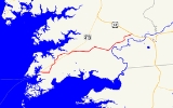
Maryland Route 667 is a 17.61 miles (28.34 km) state highway in Somerset County
in the U.S. state
of Maryland
. The east–west route runs from the city of Crisfield
, which is located on the Tangier Sound
, to U.S. Route 13
west of Pocomoke
, and passes through Hopewell, Marion
, Hudson's Corner, and Rehobeth
along the way. The route serves as a second highway into the lower Somerset County countryside, providing access to these communities from points south (as MD 413 provides access from points north).
Much of MD 667's present-day routing is the former alignment of what is now known as Maryland Route 413
, which was assigned as the route was moved to a straighter alignment paralleling the now-defunct Eastern Shore Railroad; the rest, east of Hudson's Corner and known as Rehobeth Road, was formed from absorbing MD 406 after the new alignment of MD 413 was completed. Like its successor, MD 667 is also part of the “Blue Crab Scenic Byway” and the “Beach to Bay Indian Trail”, noted on signs along the route and connecting Ocean City on the Atlantic Ocean to Smith Island in the Chesapeake Bay
.
at its beginning of state maintenance. This is located outside Crisfield's corporate limits, which is just east of the Gandy Lane intersection. The road continues westward from there as Chesapeake Avenue and intersects Somerset Avenue, a major north–south street in the city. It travels through a residential area in almost a perfect eastern trajectory until it hits a sharp, high-banked curve (known locally as “Dead Man's Curve”) which forces many drivers to slow to 20 mi/h. Now turning northeast, the road passes between Mariners Road and Cash Corner Road. Many foundations of businesses that once stood out on this route are visible in what is now field and marsh.
As it begins to parallel MD 413, Lawson Barnes Road intersects MD 667, and a gentle curve begins as it intersects the Crisfield Highway in the center of Hopewell, near Highway Holiness Church.
MD 667 enters a tree farm and makes its way east through more homes and open fields as it meets MD 413 once again and enters Marion
. It continues across the road and parallels its successor highway, passing the beginning of Whites Road in the process of curving to do so. The speed limit drops to 30 mi/h as Crisfield–Marion Road passes through the densely residential community, ending at a four-way stop composed of itself, Charles Cannon Road to the northwest, Tulls Corner Road to the southeast, and Hudson's Corner Road east, continuing MD 667.
and Marion Sarah Peyton-Elementary School, the speed limit increases to 50 mi/h. After a long, wooded stretch, it turns north at Burnettsville Road, which intersects MD 667 with two legs. It continues through another tree farm, which shortly after gives way to a residential area. After intersecting Lovers Lane and crossing a small creek, the road turns right at an intersection in Hudson's Corner, becoming Rehobeth Road. Straight through this intersection is Old Westover–Marion Road, which leads to Westover. The intersection lacks stop signs only on the eastbound side of MD 667; all other points are required to stop, though traffic turning onto Rehobeth Road is warned to slow to 15 mi/h.
. It intersects Old Rehobeth Road, a former routing of the highway when it was once known as Maryland Route 406. This road grants access to both Rehobeth and Shelltown
. Turning northeast, Vessey Orchard Road and Charles Barnes Road intersect the highway; the former road leads to an apple orchard, the latter provides an eventual link to Holly Grove Christian School.
The road winds through an area of mostly open agricultural lands, turning north and slightly west as it intersects Peach Orchard Road, a shortcut to southbound US 13. It continues north and turns east at an intersection with Overholt Road, which also links to the private school. The road bridges Puncheon Landing just before it intersects US 13
.
 In Hudson's Corner, the road that incorporates the road eastward to Pocomoke carried MD 406, which at its earliest incarnation followed what is now Old Rehobeth Road until its end at the Pocomoke River
in Rehobeth
.
As MD 413 was realigned to a new straight highway paralleling the Crisfield Secondary Branch of the Eastern Shore Railroad, MD 667 was brought into existence by the former sections of that route. The first section of what was to become "Crisfield Highway" between Crisfield and Westover was constructed in 1938 and 1939 from the eastern city limits of Crisfield (near the intersection with MD 358) to Hopewell.
By the 1960s, Rehobeth Road, still as MD 406, was moved to its current-day alignment and extended to US 13. Additionally, Somerset Avenue was removed from the list of state highways, and all of MD 667 west of it and the city line was removed from the state highway system. Additionally, after US 13 was expanded to a limited-access dual highway, MD 667's eastern terminus was truncated to it. The road east of US 13, presently Davis Store Road, was left in its original macadam
construction.
.
Somerset County, Maryland
-2010:Whereas according to the 2010 U.S. Census Bureau:*53.5% White*42.3% Black*0.3% Native American*0.7% Asian*0.0% Native Hawaiian or Pacific Islander*1.7% Two or more races*1.5% Other races*3.3% Hispanic or Latino -2000:...
in the U.S. state
U.S. state
A U.S. state is any one of the 50 federated states of the United States of America that share sovereignty with the federal government. Because of this shared sovereignty, an American is a citizen both of the federal entity and of his or her state of domicile. Four states use the official title of...
of Maryland
Maryland
Maryland is a U.S. state located in the Mid Atlantic region of the United States, bordering Virginia, West Virginia, and the District of Columbia to its south and west; Pennsylvania to its north; and Delaware to its east...
. The east–west route runs from the city of Crisfield
Crisfield, Maryland
Crisfield is a city in Somerset County, Maryland, United States, located on the Tangier Sound, an arm of the Chesapeake Bay. The population was 2,723 at the 2000 census. It is included in the Salisbury, Maryland Metropolitan Statistical Area...
, which is located on the Tangier Sound
Tangier Sound
Tangier Sound is a sound of the Chesapeake Bay bounded on the west by Tangier Island in Virginia, and Smith Island and South Marsh Island in Maryland, by Deal Island in Maryland on the north, and the mainland of the Eastern Shore of Maryland and Pocomoke Sound on the east...
, to U.S. Route 13
U.S. Route 13 in Maryland
U.S. Route 13 is a U.S. Highway running from Fayetteville, North Carolina north to Morrisville, Pennsylvania. In the U.S. state of Maryland, the route runs from the Virginia border south of Pocomoke City in Worcester County north to the Delaware border in Delmar, Wicomico County, where the route...
west of Pocomoke
Pocomoke City, Maryland
Pocomoke City, dubbed "the friendliest town on the Eastern Shore", is a city in Worcester County, Maryland, United States. Although renamed in a burst of civic enthusiasm in 1878, the city is regularly referred to by its inhabitants simply as Pocomoke...
, and passes through Hopewell, Marion
Marion Station, Maryland
Marion Station, also known as Marion, is an unincorporated community in Somerset County, Maryland, United States. It is located at the northern intersection of Maryland Route 413 and Maryland Route 667. After the arrival of the Pennsylvania Railroad arm known as the "Eastern Shore Railroad"...
, Hudson's Corner, and Rehobeth
Rehobeth, Maryland
Rehobeth is an unincorporated community in Somerset County, Maryland, United States. It is located at the east end of Old Rehobeth Road, off Rehobeth Road, on the bank of the Pocomoke River.-References:...
along the way. The route serves as a second highway into the lower Somerset County countryside, providing access to these communities from points south (as MD 413 provides access from points north).
Much of MD 667's present-day routing is the former alignment of what is now known as Maryland Route 413
Maryland Route 413
Maryland Route 413 is a state highway in Somerset County in the U.S. state of Maryland. The route runs from a dead end at Crisfield's city dock, which is located on the Tangier Sound, northeast to U.S. Route 13 in Westover. It is the main highway leading into Crisfield, and is known as...
, which was assigned as the route was moved to a straighter alignment paralleling the now-defunct Eastern Shore Railroad; the rest, east of Hudson's Corner and known as Rehobeth Road, was formed from absorbing MD 406 after the new alignment of MD 413 was completed. Like its successor, MD 667 is also part of the “Blue Crab Scenic Byway” and the “Beach to Bay Indian Trail”, noted on signs along the route and connecting Ocean City on the Atlantic Ocean to Smith Island in the Chesapeake Bay
Chesapeake Bay
The Chesapeake Bay is the largest estuary in the United States. It lies off the Atlantic Ocean, surrounded by Maryland and Virginia. The Chesapeake Bay's drainage basin covers in the District of Columbia and parts of six states: New York, Pennsylvania, Delaware, Maryland, Virginia, and West...
.
Old State Road
Maryland Route 667 begins in CrisfieldCrisfield, Maryland
Crisfield is a city in Somerset County, Maryland, United States, located on the Tangier Sound, an arm of the Chesapeake Bay. The population was 2,723 at the 2000 census. It is included in the Salisbury, Maryland Metropolitan Statistical Area...
at its beginning of state maintenance. This is located outside Crisfield's corporate limits, which is just east of the Gandy Lane intersection. The road continues westward from there as Chesapeake Avenue and intersects Somerset Avenue, a major north–south street in the city. It travels through a residential area in almost a perfect eastern trajectory until it hits a sharp, high-banked curve (known locally as “Dead Man's Curve”) which forces many drivers to slow to 20 mi/h. Now turning northeast, the road passes between Mariners Road and Cash Corner Road. Many foundations of businesses that once stood out on this route are visible in what is now field and marsh.
As it begins to parallel MD 413, Lawson Barnes Road intersects MD 667, and a gentle curve begins as it intersects the Crisfield Highway in the center of Hopewell, near Highway Holiness Church.
Crisfield-Marion Road
MD 667 continues across MD 413, now taking on the name Crisfield–Marion Road. The scenery changes from mostly residential to mostly agricultural, and the speed limit rises to 40 mi/h. A sharp right curve sends the highway past Saint Peter's Church Road, named for a historic church that has stood for nearly a century. As it continues, turning north, it intersects Hearts Ease Road and, eventually, the western end of Holland Crossing Road which once connected to Hearts Ease Road.MD 667 enters a tree farm and makes its way east through more homes and open fields as it meets MD 413 once again and enters Marion
Marion Station, Maryland
Marion Station, also known as Marion, is an unincorporated community in Somerset County, Maryland, United States. It is located at the northern intersection of Maryland Route 413 and Maryland Route 667. After the arrival of the Pennsylvania Railroad arm known as the "Eastern Shore Railroad"...
. It continues across the road and parallels its successor highway, passing the beginning of Whites Road in the process of curving to do so. The speed limit drops to 30 mi/h as Crisfield–Marion Road passes through the densely residential community, ending at a four-way stop composed of itself, Charles Cannon Road to the northwest, Tulls Corner Road to the southeast, and Hudson's Corner Road east, continuing MD 667.
Hudson's Corner Road
It follows the latter road out of town, travelling east, and after it passes the Marion post officePost office
A post office is a facility forming part of a postal system for the posting, receipt, sorting, handling, transmission or delivery of mail.Post offices offer mail-related services such as post office boxes, postage and packaging supplies...
and Marion Sarah Peyton-Elementary School, the speed limit increases to 50 mi/h. After a long, wooded stretch, it turns north at Burnettsville Road, which intersects MD 667 with two legs. It continues through another tree farm, which shortly after gives way to a residential area. After intersecting Lovers Lane and crossing a small creek, the road turns right at an intersection in Hudson's Corner, becoming Rehobeth Road. Straight through this intersection is Old Westover–Marion Road, which leads to Westover. The intersection lacks stop signs only on the eastbound side of MD 667; all other points are required to stop, though traffic turning onto Rehobeth Road is warned to slow to 15 mi/h.
Rehobeth Road
Now taking on the name Rehobeth Road, MD 667 immediately passes over Marumsco Creek and keeps up its 50 mi/h speed limit as it passes by the area known as RehobethRehobeth, Maryland
Rehobeth is an unincorporated community in Somerset County, Maryland, United States. It is located at the east end of Old Rehobeth Road, off Rehobeth Road, on the bank of the Pocomoke River.-References:...
. It intersects Old Rehobeth Road, a former routing of the highway when it was once known as Maryland Route 406. This road grants access to both Rehobeth and Shelltown
Shelltown, Maryland
Shelltown is an unincorporated community in Somerset County, Maryland, United States. It is near the mouth of the Pocomoke River and takes its name from the abundant number of oysters and crabs in the area....
. Turning northeast, Vessey Orchard Road and Charles Barnes Road intersect the highway; the former road leads to an apple orchard, the latter provides an eventual link to Holly Grove Christian School.
The road winds through an area of mostly open agricultural lands, turning north and slightly west as it intersects Peach Orchard Road, a shortcut to southbound US 13. It continues north and turns east at an intersection with Overholt Road, which also links to the private school. The road bridges Puncheon Landing just before it intersects US 13
U.S. Route 13 in Maryland
U.S. Route 13 is a U.S. Highway running from Fayetteville, North Carolina north to Morrisville, Pennsylvania. In the U.S. state of Maryland, the route runs from the Virginia border south of Pocomoke City in Worcester County north to the Delaware border in Delmar, Wicomico County, where the route...
.
History
At the turn of the 20th century, Crisfield was the second largest city in the state of Maryland and a busy center of activity. The importance of the city of Crisfield led to its main access road, the Crisfield–Westover Road, to become one of the roads slated for improvement by the Maryland State Roads Commission in 1909. Once the Maryland state highway systems was started in 1927, the route was given the designation of MD 413. As it first existed, the Crisfield–Westover Road began at the Crisfield city docks on Main Street, continuing west on present-day Chesapeake Avenue and Old State Road, following the present-day MD 667. It passed through Hopewell near its train station and eventually entered Marion on what was then its Main Street, and continued all the way to Hudson's Corner. Here, the route continued straight onto Old Westover–Marion Road. In Westover, it continued straight onto Sign Post Road, and turned east onto Sam Barnes Road. The road continued eastward from where US 13 is today along an alignment that no longer exists to end at Old Princess Anne Road, a former alignment of US 13.Pocomoke River
The Pocomoke River stretches approximately from southern Delaware through southeastern Maryland in the United States. At its mouth, the river is essentially an arm of Chesapeake Bay, whereas the upper river flows through a series of relatively inaccessible wetlands called the Great Cypress Swamp,...
in Rehobeth
Rehobeth, Maryland
Rehobeth is an unincorporated community in Somerset County, Maryland, United States. It is located at the east end of Old Rehobeth Road, off Rehobeth Road, on the bank of the Pocomoke River.-References:...
.
As MD 413 was realigned to a new straight highway paralleling the Crisfield Secondary Branch of the Eastern Shore Railroad, MD 667 was brought into existence by the former sections of that route. The first section of what was to become "Crisfield Highway" between Crisfield and Westover was constructed in 1938 and 1939 from the eastern city limits of Crisfield (near the intersection with MD 358) to Hopewell.
By the 1960s, Rehobeth Road, still as MD 406, was moved to its current-day alignment and extended to US 13. Additionally, Somerset Avenue was removed from the list of state highways, and all of MD 667 west of it and the city line was removed from the state highway system. Additionally, after US 13 was expanded to a limited-access dual highway, MD 667's eastern terminus was truncated to it. The road east of US 13, presently Davis Store Road, was left in its original macadam
Macadam
Macadam is a type of road construction pioneered by the Scotsman John Loudon McAdam in around 1820. The method simplified what had been considered state-of-the-art at that point...
construction.
Junction list
The entire route is in Somerset CountySomerset County, Maryland
-2010:Whereas according to the 2010 U.S. Census Bureau:*53.5% White*42.3% Black*0.3% Native American*0.7% Asian*0.0% Native Hawaiian or Pacific Islander*1.7% Two or more races*1.5% Other races*3.3% Hispanic or Latino -2000:...
.
| Location | Mile | Destinations | Notes |
|---|---|---|---|
| Crisfield Crisfield, Maryland Crisfield is a city in Somerset County, Maryland, United States, located on the Tangier Sound, an arm of the Chesapeake Bay. The population was 2,723 at the 2000 census. It is included in the Salisbury, Maryland Metropolitan Statistical Area... |
0.00 | Begin state maintenance – east of Somerset Avenue | Western terminus |
| Hopewell | 2.77 | ||
| Marion Station Marion Station, Maryland Marion Station, also known as Marion, is an unincorporated community in Somerset County, Maryland, United States. It is located at the northern intersection of Maryland Route 413 and Maryland Route 667. After the arrival of the Pennsylvania Railroad arm known as the "Eastern Shore Railroad"... |
5.81 | ||
| 6.55 | Charles Cannon Road west / Tulls Corner Road east – Tulls Corner Tulls Corner, Maryland Tulls Corner is an unincorporated community in Somerset County, Maryland, United States.-History:Tulls Corner is located in Quindocqua just west of Quindocqua United Methodist Church, at the intersection of Tulls Corner Road and L. Q. Powell Road, near Marion Station, Maryland... |
Former MD 357 (removed 1991) Becomes Hudson Corner Road |
|
| Hudson's Corner | 10.39 | Old Westover–Marion Road – Westover Westover, Maryland Westover is an unincorporated community in Somerset County, Maryland, United States. It is located on Maryland Route 413 near its terminus at U.S. Route 13. The small community is home to many important services in Somerset County.... |
Former MD 413 |
| Rehobeth Rehobeth, Maryland Rehobeth is an unincorporated community in Somerset County, Maryland, United States. It is located at the east end of Old Rehobeth Road, off Rehobeth Road, on the bank of the Pocomoke River.-References:... |
11.90 | Old Rehobeth Road to Shelltown Road – Rehobeth Rehobeth, Maryland Rehobeth is an unincorporated community in Somerset County, Maryland, United States. It is located at the east end of Old Rehobeth Road, off Rehobeth Road, on the bank of the Pocomoke River.-References:... , Shelltown Shelltown, Maryland Shelltown is an unincorporated community in Somerset County, Maryland, United States. It is near the mouth of the Pocomoke River and takes its name from the abundant number of oysters and crabs in the area.... |
|
| Pocomoke City Pocomoke City, Maryland Pocomoke City, dubbed "the friendliest town on the Eastern Shore", is a city in Worcester County, Maryland, United States. Although renamed in a burst of civic enthusiasm in 1878, the city is regularly referred to by its inhabitants simply as Pocomoke... |
15.96 | ||
| 17.61 | Eastern terminus | ||