
Maryland Route 361
Encyclopedia
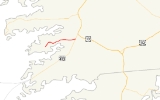
Maryland Route 361 is a state highway
in the U.S. state
of Maryland
. Known as Fairmount Road, the state highway runs 5.62 miles (9 km) from the beginning of state maintenance in Upper Fairmount
east to MD 413
in Westover
. MD 361 provides access to the villages of Manokin
and Upper Fairmount, while the county-maintained portion of Fairmount Road continues west toward the communities of Fairmount
, Frenchtown
, and Rumbly
. The state highway was constructed from the Westover end beginning in 1926. MD 361 was completed west through Upper Fairmount in the early 1930s.
, passing Upper Hill Road and an old alignment of the highway, Jones Factory Road, before leaving Upper Fairmount and passing through the Chesapeake Forest Lands. The state highway leaves the forest and passes through the hamlet of Manokin, where the highway intersects Millard Long Road, which heads north toward Revells Neck, and River Road, which heads south toward Kingston
. MD 361 passes the county landfill and Charles Layfield Road before reaching its eastern terminus at MD 413 (Crisfield Highway). Ritzel Road, the old alignment of MD 361, continues east to its terminus at Old Westover–Marion Road, the old alignment of MD 413.
.
{| class=wikitable
!Location
!Mile
!Destinations
!Notes
|-
|rowspan=1|Upper Fairmount
|0.00
|Fairmount Road west – Fairmount
|Western terminus
|-
|rowspan=2|Westover
|rowspan=2|5.62
|
|rowspan=2|Eastern terminus; Ritzel Road is old alignment of MD 361
|-
|Ritzel Road east
State highway
State highway, state road or state route can refer to one of three related concepts, two of them related to a state or provincial government in a country that is divided into states or provinces :#A...
in the U.S. state
U.S. state
A U.S. state is any one of the 50 federated states of the United States of America that share sovereignty with the federal government. Because of this shared sovereignty, an American is a citizen both of the federal entity and of his or her state of domicile. Four states use the official title of...
of Maryland
Maryland
Maryland is a U.S. state located in the Mid Atlantic region of the United States, bordering Virginia, West Virginia, and the District of Columbia to its south and west; Pennsylvania to its north; and Delaware to its east...
. Known as Fairmount Road, the state highway runs 5.62 miles (9 km) from the beginning of state maintenance in Upper Fairmount
Upper Fairmount, Maryland
Upper Fairmount is an unincorporated community in Somerset County, Maryland, United States. It is located at the intersection of Maryland Route 361 and Upper Hill Road.-References:...
east to MD 413
Maryland Route 413
Maryland Route 413 is a state highway in Somerset County in the U.S. state of Maryland. The route runs from a dead end at Crisfield's city dock, which is located on the Tangier Sound, northeast to U.S. Route 13 in Westover. It is the main highway leading into Crisfield, and is known as...
in Westover
Westover, Maryland
Westover is an unincorporated community in Somerset County, Maryland, United States. It is located on Maryland Route 413 near its terminus at U.S. Route 13. The small community is home to many important services in Somerset County....
. MD 361 provides access to the villages of Manokin
Manokin, Maryland
Manokin is an unincorporated community in Somerset County, Maryland, United States. It is located on Maryland Route 361 at the intersection of River Road.-References:...
and Upper Fairmount, while the county-maintained portion of Fairmount Road continues west toward the communities of Fairmount
Fairmount, Maryland
Fairmount is a census-designated place in Somerset County, Maryland, United States. The population was 537 at the 2000 census. It is included in the Salisbury, Maryland Metropolitan Statistical Area.-Geography:...
, Frenchtown
Frenchtown-Rumbly, Maryland
Frenchtown-Rumbly is a census-designated place in Somerset County, Maryland, United States. The population was 96 at the 2000 census. It is included in the Salisbury, Maryland Metropolitan Statistical Area.-Geography:...
, and Rumbly
Frenchtown-Rumbly, Maryland
Frenchtown-Rumbly is a census-designated place in Somerset County, Maryland, United States. The population was 96 at the 2000 census. It is included in the Salisbury, Maryland Metropolitan Statistical Area.-Geography:...
. The state highway was constructed from the Westover end beginning in 1926. MD 361 was completed west through Upper Fairmount in the early 1930s.
Route description
MD 361 begins on Fairmount Road between the Fairmount Volunteer Fire Department and Clinton Bozman Road on the west edge of Upper Fairmount. Fairmount Road continues west as a county highway toward Fairmount, Frenchtown, and Rumbly. MD 361 heads east through the Upper Fairmount Historic DistrictUpper Fairmount Historic District
Upper Fairmount Historic District is a national historic district at Upper Fairmount, Somerset County, Maryland, United States. The district encompasses this quiet rural village situated along Fairmount Road . The village is landlocked, rural in character, and surrounded by farms, fields, wooded...
, passing Upper Hill Road and an old alignment of the highway, Jones Factory Road, before leaving Upper Fairmount and passing through the Chesapeake Forest Lands. The state highway leaves the forest and passes through the hamlet of Manokin, where the highway intersects Millard Long Road, which heads north toward Revells Neck, and River Road, which heads south toward Kingston
Kingston, Maryland
Kingston is an unincorporated community in Somerset County, Maryland, United States. A small community at the head of navigation of the Big Annemessex River, it is located on Maryland Route 413 at the intersection of Kingston Lane...
. MD 361 passes the county landfill and Charles Layfield Road before reaching its eastern terminus at MD 413 (Crisfield Highway). Ritzel Road, the old alignment of MD 361, continues east to its terminus at Old Westover–Marion Road, the old alignment of MD 413.
History
The first section of MD 361 was constructed in 1926 from the old alignment of MD 413 west to Charles Layfield Road. The highway was extended west through Manokin by 1930. MD 361 was completed through Upper Fairmount in 1933. The part of the state highway between MD 413 and the old alignment of MD 413 was removed from state maintenance by 1961.Junction list
The entire route is in Somerset CountySomerset County, Maryland
-2010:Whereas according to the 2010 U.S. Census Bureau:*53.5% White*42.3% Black*0.3% Native American*0.7% Asian*0.0% Native Hawaiian or Pacific Islander*1.7% Two or more races*1.5% Other races*3.3% Hispanic or Latino -2000:...
.
{| class=wikitable
!Location
!Mile
!Destinations
!Notes
|-
|rowspan=1|Upper Fairmount
Upper Fairmount, Maryland
Upper Fairmount is an unincorporated community in Somerset County, Maryland, United States. It is located at the intersection of Maryland Route 361 and Upper Hill Road.-References:...
|0.00
|Fairmount Road west – Fairmount
Fairmount, Maryland
Fairmount is a census-designated place in Somerset County, Maryland, United States. The population was 537 at the 2000 census. It is included in the Salisbury, Maryland Metropolitan Statistical Area.-Geography:...
|Western terminus
|-
|rowspan=2|Westover
Westover, Maryland
Westover is an unincorporated community in Somerset County, Maryland, United States. It is located on Maryland Route 413 near its terminus at U.S. Route 13. The small community is home to many important services in Somerset County....
|rowspan=2|5.62
|
|rowspan=2|Eastern terminus; Ritzel Road is old alignment of MD 361
|-
|Ritzel Road east