
Maryland Route 358
Encyclopedia
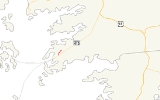
Maryland Route 358 is a state highway
in the U.S. state
of Maryland
. Known as Jacksonville Road, the state highway runs 1.13 miles (1.8 km) from MD 413
in Crisfield
north to the end of state maintenance near Alfred J. Lawson Road. MD 358 connects Crisfield with Janes Island State Park
and Crisfield Municipal Airport
. MD 358 was constructed on the south side of Crisfield in the mid 1920s. What is now MD 358 north of MD 413 was originally MD 475, which was built in the early 1930s. MD 358 was extended north through Crisfield in the 1940s, taking over MD 475. The portion of MD 358 south of MD 413 was later returned to the city of Crisfield and Somerset County
.
—Richardson Avenue running northbound and Maryland Avenue running southbound—around a median that once featured the Crisfield Secondary track of the Pennsylvania Railroad
. Somerset Avenue, which was once part of MD 358, heads south from the junction as a city street toward Crisfield Academy and High School and the Crisfield Historic District
. MD 358 heads north as two-lane Jacksonville Road. The state highway is maintained by the city of Crisfield for 0.09 mile (0.1448406 km) north to the city limits, where state maintenance begins. MD 358 passes through a residential area that transitions to farmland as the highway approaches Box Iron Road, which is the old alignment of MD 358 and is now unsigned
MD 358A. Immediately beyond Box Iron Road, the state highway intersects Alfred J. Lawson Road, which leads to the main entrance to Janes Island State Park, then reaches its northern terminus at the end of state maintenance. Jacksonville Road continues north as a county highway toward Crisfield Municipal Airport.
. The Asbury Road segment connected Crisfield with Sackertown Road, which was once MD 360. Another section of MD 358 was paved from the Pennsylvania Railroad
(now the MD 413 corridor) to its present northern terminus in 1933; this segment was originally designated MD 475. MD 358 was extended north along Somerset Avenue to Chesapeake Avenue (MD 667) by 1939 and to its present northern terminus by 1946, assuming MD 475. The state highway along Somerset Avenue was widened from Main Street to MD 413 around 1954. MD 358 was removed from the state highway system south of MD 413 by 1995. The state highway was relocated at Box Iron Road to eliminate two sharp curves between 1988 and 1999.
.
{|class=wikitable
!Location
!Mile
!Destinations
!Notes
|-
|rowspan=2|Crisfield
|rowspan=2|0.00
|Somerset Avenue south
|rowspan=2|Southern terminus; Somerset Avenue is former MD 358; MD 413 is Richardson Avenue northbound and Maryland Avenue southbound
|-
|
|-
|rowspan=2|
|1.11
|Alfred J. Lawson Road west – Janes Island State Park
|
|-
|1.13
|Jacksonville Road north – Crisfield Municipal Airport
|Northern terminus
State highway
State highway, state road or state route can refer to one of three related concepts, two of them related to a state or provincial government in a country that is divided into states or provinces :#A...
in the U.S. state
U.S. state
A U.S. state is any one of the 50 federated states of the United States of America that share sovereignty with the federal government. Because of this shared sovereignty, an American is a citizen both of the federal entity and of his or her state of domicile. Four states use the official title of...
of Maryland
Maryland
Maryland is a U.S. state located in the Mid Atlantic region of the United States, bordering Virginia, West Virginia, and the District of Columbia to its south and west; Pennsylvania to its north; and Delaware to its east...
. Known as Jacksonville Road, the state highway runs 1.13 miles (1.8 km) from MD 413
Maryland Route 413
Maryland Route 413 is a state highway in Somerset County in the U.S. state of Maryland. The route runs from a dead end at Crisfield's city dock, which is located on the Tangier Sound, northeast to U.S. Route 13 in Westover. It is the main highway leading into Crisfield, and is known as...
in Crisfield
Crisfield, Maryland
Crisfield is a city in Somerset County, Maryland, United States, located on the Tangier Sound, an arm of the Chesapeake Bay. The population was 2,723 at the 2000 census. It is included in the Salisbury, Maryland Metropolitan Statistical Area...
north to the end of state maintenance near Alfred J. Lawson Road. MD 358 connects Crisfield with Janes Island State Park
Janes Island State Park
Janes Island State Park is a state park in the state of Maryland. It is located in Somerset County, Maryland, on the Chesapeake Bay. The park features boat launch, canoe/kayak rental, cabins, camp fire programs, camp sites, camp store, dump station, fishing and crabbing, flat water canoeing and...
and Crisfield Municipal Airport
Crisfield Municipal Airport
Crisfield Municipal Airport is a public airport located from Crisfield in Somerset County, Maryland, United States. Crisfield is located near the center of the Delmarva Peninsula in the heart of Bay Country. The Atlantic Ocean is to the east and the Chesapeake Bay just a few miles to the west...
. MD 358 was constructed on the south side of Crisfield in the mid 1920s. What is now MD 358 north of MD 413 was originally MD 475, which was built in the early 1930s. MD 358 was extended north through Crisfield in the 1940s, taking over MD 475. The portion of MD 358 south of MD 413 was later returned to the city of Crisfield and Somerset County
Somerset County, Maryland
-2010:Whereas according to the 2010 U.S. Census Bureau:*53.5% White*42.3% Black*0.3% Native American*0.7% Asian*0.0% Native Hawaiian or Pacific Islander*1.7% Two or more races*1.5% Other races*3.3% Hispanic or Latino -2000:...
.
Route description
MD 358 begins at an intersection with MD 413 in the city of Crisfield. MD 413 is formed by a one-way pairOne-way pair
A one-way pair, one-way couple, or just couplet is a pair of parallel, usually one-way streets that carry opposite directions of a signed route or major traffic flow, or sometimes opposite directions of a bus or streetcar route....
—Richardson Avenue running northbound and Maryland Avenue running southbound—around a median that once featured the Crisfield Secondary track of the Pennsylvania Railroad
Pennsylvania Railroad
The Pennsylvania Railroad was an American Class I railroad, founded in 1846. Commonly referred to as the "Pennsy", the PRR was headquartered in Philadelphia, Pennsylvania....
. Somerset Avenue, which was once part of MD 358, heads south from the junction as a city street toward Crisfield Academy and High School and the Crisfield Historic District
Crisfield Historic District
Crisfield Historic District is a national historic district at Crisfield, Somerset County, Maryland, United States. It consists of a cohesive collection of houses, churches, and commercial buildings dating primarily from about 1870 to 1930. They reflect the rapid growth of the town as the center...
. MD 358 heads north as two-lane Jacksonville Road. The state highway is maintained by the city of Crisfield for 0.09 mile (0.1448406 km) north to the city limits, where state maintenance begins. MD 358 passes through a residential area that transitions to farmland as the highway approaches Box Iron Road, which is the old alignment of MD 358 and is now unsigned
Unsigned highway
An unsigned highway is a highway that has been assigned a route number, but does not bear conventional road markings that would normally be used to identify the route with that number...
MD 358A. Immediately beyond Box Iron Road, the state highway intersects Alfred J. Lawson Road, which leads to the main entrance to Janes Island State Park, then reaches its northern terminus at the end of state maintenance. Jacksonville Road continues north as a county highway toward Crisfield Municipal Airport.
History
MD 358 was first constructed in 1925 along Somerset Avenue south from the Crisfield city limits and east along Asbury Road to Lawsonia Road, which later became MD 380Maryland Route 380
Maryland Route 380 is a state highway in the U.S. state of Maryland. The state highway runs from Ape Hole Road in Lawsonia, Maryland north to Main Street at the city limit of Crisfield in southwestern Somerset County. MD 380, which is the southernmost state highway in Maryland, provides access...
. The Asbury Road segment connected Crisfield with Sackertown Road, which was once MD 360. Another section of MD 358 was paved from the Pennsylvania Railroad
Pennsylvania Railroad
The Pennsylvania Railroad was an American Class I railroad, founded in 1846. Commonly referred to as the "Pennsy", the PRR was headquartered in Philadelphia, Pennsylvania....
(now the MD 413 corridor) to its present northern terminus in 1933; this segment was originally designated MD 475. MD 358 was extended north along Somerset Avenue to Chesapeake Avenue (MD 667) by 1939 and to its present northern terminus by 1946, assuming MD 475. The state highway along Somerset Avenue was widened from Main Street to MD 413 around 1954. MD 358 was removed from the state highway system south of MD 413 by 1995. The state highway was relocated at Box Iron Road to eliminate two sharp curves between 1988 and 1999.
Junction list
The entire route is in Somerset CountySomerset County, Maryland
-2010:Whereas according to the 2010 U.S. Census Bureau:*53.5% White*42.3% Black*0.3% Native American*0.7% Asian*0.0% Native Hawaiian or Pacific Islander*1.7% Two or more races*1.5% Other races*3.3% Hispanic or Latino -2000:...
.
{|class=wikitable
!Location
!Mile
!Destinations
!Notes
|-
|rowspan=2|Crisfield
Crisfield, Maryland
Crisfield is a city in Somerset County, Maryland, United States, located on the Tangier Sound, an arm of the Chesapeake Bay. The population was 2,723 at the 2000 census. It is included in the Salisbury, Maryland Metropolitan Statistical Area...
|rowspan=2|0.00
|Somerset Avenue south
|rowspan=2|Southern terminus; Somerset Avenue is former MD 358; MD 413 is Richardson Avenue northbound and Maryland Avenue southbound
|-
|
|-
|rowspan=2|
|1.11
|Alfred J. Lawson Road west – Janes Island State Park
Janes Island State Park
Janes Island State Park is a state park in the state of Maryland. It is located in Somerset County, Maryland, on the Chesapeake Bay. The park features boat launch, canoe/kayak rental, cabins, camp fire programs, camp sites, camp store, dump station, fishing and crabbing, flat water canoeing and...
|
|-
|1.13
|Jacksonville Road north – Crisfield Municipal Airport
Crisfield Municipal Airport
Crisfield Municipal Airport is a public airport located from Crisfield in Somerset County, Maryland, United States. Crisfield is located near the center of the Delmarva Peninsula in the heart of Bay Country. The Atlantic Ocean is to the east and the Chesapeake Bay just a few miles to the west...
|Northern terminus