
Maryland Route 227
Encyclopedia
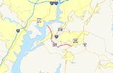
Maryland Route 227 is a state highway
in the U.S. state
of Maryland
. The state highway runs 13.96 miles (22.5 km) from Marshall Hall
east to U.S. Route 301
(US 301) in White Plains
. MD 227 connects the communities of Bryans Road
, Pomonkey, and Pomfret
in northwestern Charles County
. The state highway, which was constructed in the mid 1920s and early 1930s, originally had its western terminus at Pomonkey; the remainder of the current route was part of MD 224
and all of MD 226. MD 227 gained its present western terminus in the mid 1950s.
adjacent to the ruins of the namesake mansion at Marshall Hall within Piscataway Park
. The state highway heads south as Marshall Hall Road, a two-lane road through a forested area. MD 227 crosses Mill Swamp and begins to pass residential subdivisions as the highway approaches the community of Bryans Road, where the highway intersections MD 210 (Indian Head Highway). The state highway continues south as Livingston Road to Pomonkey, where MD 224 continues southwest as Livingston Road toward Mason Springs while MD 227 veers southeast as Pomfret Road. The state highway crosses Mattawoman Creek
, passes by the historic farm McPherson's Purchase
, and intersects the Indian Head Rail Trail on its way to Pomfret, where the highway meets Marshall Corner Road. MD 227 turns north onto Marshall Corner Road, curving to the east and passing the entrance to Green's Inheritance
before meeting the southern end of MD 229 (Bensville Road). East of Pomfret, the state highway passes close to another pair of historic homes, Pleasant Hill
and Oak Grove
, the latter of which is on the intersecting Turkey Hill Road. MD 227 crosses Pages Swamp and passes close to another historic home, Spye Park
, before reaching White Plains, where the state highway reaches its eastern terminus at US 301 (Robert Crain Highway) opposite county-maintained Willetts Crossing Road.
at Doncaster to the District of Columbia in Forest Heights
. Marshall Hall Road was built as MD 226 between 1924 and 1927. MD 227's portion of Marshall Corner Road was constructed between 1924 and 1926. The final portion of MD 227, Pomfret Road, was started in 1929 and complete from Marshall Corner Road to the bridge over Mattawoman Creek in 1930. The gap between Mattawoman Creek and Livingston Road was filled by 1933. MD 227 was extended north over Livingston Road and Marshall Hall Road to its present western terminus, taking over all of MD 226's course, in 1956.
.
{| class=wikitable
!Location
!Mile
!Destinations
!Notes
|-
|Marshall Hall
|0.00
|Road end at Potomac River
|Western terminus
|-
|Bryans Road
|4.51
|
|
|-
|Pomonkey
|5.84
|
|
|-
|rowspan=2|Pomfret
|9.04
|Marshall Corner Road south
|MD 227 turns north onto Marshall Corner Road
|-
|10.16
|
|
|-
|White Plains
|13.96
|
|Eastern terminus
State highway
State highway, state road or state route can refer to one of three related concepts, two of them related to a state or provincial government in a country that is divided into states or provinces :#A...
in the U.S. state
U.S. state
A U.S. state is any one of the 50 federated states of the United States of America that share sovereignty with the federal government. Because of this shared sovereignty, an American is a citizen both of the federal entity and of his or her state of domicile. Four states use the official title of...
of Maryland
Maryland
Maryland is a U.S. state located in the Mid Atlantic region of the United States, bordering Virginia, West Virginia, and the District of Columbia to its south and west; Pennsylvania to its north; and Delaware to its east...
. The state highway runs 13.96 miles (22.5 km) from Marshall Hall
Marshall Hall, Maryland
Marshall Hall, Maryland is the site of the Marshall family mansion. Marshall Hall is located near Bryan's Road in Charles County, Maryland, next to the Potomac River, more or less across from Mount Vernon, Virginia, the home of George Washington. The home was one of the finest built on the...
east to U.S. Route 301
U.S. Route 301 in Maryland
U.S. Route 301 in Maryland is a major highway that runs from Delaware to the Governor Harry W. Nice Memorial Bridge into Virginia. It passes through three of Maryland's four main regions: the Eastern Shore, the Baltimore-Washington Metropolitan Area, and Southern Maryland...
(US 301) in White Plains
White Plains, Maryland
White Plains is an unincorporated community located in Charles County in the State of Maryland in the United States of America, just south of Waldorf, Maryland. It is located at latitude 38°35'25" North; longitude 76°56'26" West. The United States Postal Service has assigned White Plains the ZIP...
. MD 227 connects the communities of Bryans Road
Bryans Road, Maryland
Bryans Road is a census-designated place in Charles County, Maryland, United States. Bryans Road was named after Oliver Norris Bryan, a 19th century farmer and scientist who owned and operated Locust Grove Farm near Marshall Hall, Maryland. The area consisted mostly of tobacco farms until the...
, Pomonkey, and Pomfret
Pomfret, Maryland
Pomfret is a small crossroads in Charles County, Maryland. Maurice J. McDonough High School is nearby and has a Pomfret mailing address. The active historic Catholic church established by Father George Hunter, S.J. in 1763 is located in Pomfret. The current structure dates from 1849...
in northwestern Charles County
Charles County, Maryland
Charles County is a county in the south central portion of the U.S. state of Maryland.As of 2010, the population was 146,551. Its county seat is La Plata. This county was named for Charles Calvert , third Baron Baltimore....
. The state highway, which was constructed in the mid 1920s and early 1930s, originally had its western terminus at Pomonkey; the remainder of the current route was part of MD 224
Maryland Route 224
Maryland Route 224 is a state highway in the U.S. state of Maryland. The state highway runs from MD 6 in Riverside north to MD 227 in Pomonkey. MD 224 is one of the main highways of southwestern Charles County, connecting several villages, state parks, and preserves along the Potomac River and...
and all of MD 226. MD 227 gained its present western terminus in the mid 1950s.
Route description
MD 227 begins at a boat ramp on the Potomac RiverPotomac River
The Potomac River flows into the Chesapeake Bay, located along the mid-Atlantic coast of the United States. The river is approximately long, with a drainage area of about 14,700 square miles...
adjacent to the ruins of the namesake mansion at Marshall Hall within Piscataway Park
Piscataway Park
Piscataway Park, located southwest of downtown Washington, D.C., near Accokeek, Maryland, protects Marshall Hall and the National Colonial Farm. The park is located across the Potomac River from George Washington's Mount Vernon estate....
. The state highway heads south as Marshall Hall Road, a two-lane road through a forested area. MD 227 crosses Mill Swamp and begins to pass residential subdivisions as the highway approaches the community of Bryans Road, where the highway intersections MD 210 (Indian Head Highway). The state highway continues south as Livingston Road to Pomonkey, where MD 224 continues southwest as Livingston Road toward Mason Springs while MD 227 veers southeast as Pomfret Road. The state highway crosses Mattawoman Creek
Mattawoman Creek
Mattawoman Creek is a coastal-plain tributary to the tidal Potomac River with a mouth at Indian Head, Maryland, downstream of Washington, D.C. It comprises a river flowing through Prince George's and Charles counties and a tidal-freshwater estuary in Charles County...
, passes by the historic farm McPherson's Purchase
McPherson's Purchase
McPherson's Purchase is a historic farm complex dating to the 19th century and located near Pomfret, Charles County, Maryland, United States....
, and intersects the Indian Head Rail Trail on its way to Pomfret, where the highway meets Marshall Corner Road. MD 227 turns north onto Marshall Corner Road, curving to the east and passing the entrance to Green's Inheritance
Green's Inheritance
Green's Inheritance is a historic home located at Pomfret, Charles County, Maryland, United States. It is a -story gable-roofed house of common bond brick, built about 1850. The house has a basic Georgian plan. It is the only brick house in Charles County dating between the years 1835 and 1880...
before meeting the southern end of MD 229 (Bensville Road). East of Pomfret, the state highway passes close to another pair of historic homes, Pleasant Hill
Pleasant Hill (Pomfret, Maryland)
Pleasant Hill is a historic home located near Pomfret, Charles County, Maryland, United States. It is a -story, three-bay Tidewater house constructed between 1761 and 1848...
and Oak Grove
Oak Grove (La Plata, Maryland)
Oak Grove is a historic home located at La Plata, Charles County, Maryland, United States. It was built in the early Federal style about 1800, and is a one story, two part brick house of Flemish bond masonry. Two outbuildings date from the 19th century: a small frame dependency built about 1830,...
, the latter of which is on the intersecting Turkey Hill Road. MD 227 crosses Pages Swamp and passes close to another historic home, Spye Park
Spye Park (White Plains, Maryland)
Spye Park is a historic home located at White Plains, Charles County, Maryland, United States. It is a modestly scaled, -story, three-bay frame Colonial dwelling built about 1767. The house's present plan and appearance is the result of a series of 19th- and early-20th-century alterations to the...
, before reaching White Plains, where the state highway reaches its eastern terminus at US 301 (Robert Crain Highway) opposite county-maintained Willetts Crossing Road.
History
Present-day MD 227 was built as part of three different state highways. Livingston Road between Bryans Road and Pomonkey was constructed around 1923 as part of MD 224, which originally ran from MD 6Maryland Route 6
Maryland Route 6 is a state highway in the U.S. state of Maryland. The state highway runs from a dead end at the Potomac River in Riverside east to MD 235 in Oraville. MD 6 connects several small communities in southern Charles County and northern St. Mary's County with U.S. Route 301 in La...
at Doncaster to the District of Columbia in Forest Heights
Forest Heights, Maryland
Forest Heights, officially the Town of Forest Heights is a town in Prince George's County, Maryland, United States, with an African-American majority population, and part of the larger postal designation Oxon Hill, MD. Students attend Oxon Hill High School. The town straddles both sides of...
. Marshall Hall Road was built as MD 226 between 1924 and 1927. MD 227's portion of Marshall Corner Road was constructed between 1924 and 1926. The final portion of MD 227, Pomfret Road, was started in 1929 and complete from Marshall Corner Road to the bridge over Mattawoman Creek in 1930. The gap between Mattawoman Creek and Livingston Road was filled by 1933. MD 227 was extended north over Livingston Road and Marshall Hall Road to its present western terminus, taking over all of MD 226's course, in 1956.
Junction list
The entire route is in Charles CountyCharles County, Maryland
Charles County is a county in the south central portion of the U.S. state of Maryland.As of 2010, the population was 146,551. Its county seat is La Plata. This county was named for Charles Calvert , third Baron Baltimore....
.
{| class=wikitable
!Location
!Mile
!Destinations
!Notes
|-
|Marshall Hall
Marshall Hall, Maryland
Marshall Hall, Maryland is the site of the Marshall family mansion. Marshall Hall is located near Bryan's Road in Charles County, Maryland, next to the Potomac River, more or less across from Mount Vernon, Virginia, the home of George Washington. The home was one of the finest built on the...
|0.00
|Road end at Potomac River
Potomac River
The Potomac River flows into the Chesapeake Bay, located along the mid-Atlantic coast of the United States. The river is approximately long, with a drainage area of about 14,700 square miles...
|Western terminus
|-
|Bryans Road
Bryans Road, Maryland
Bryans Road is a census-designated place in Charles County, Maryland, United States. Bryans Road was named after Oliver Norris Bryan, a 19th century farmer and scientist who owned and operated Locust Grove Farm near Marshall Hall, Maryland. The area consisted mostly of tobacco farms until the...
|4.51
|
|
|-
|Pomonkey
|5.84
|
|
|-
|rowspan=2|Pomfret
Pomfret, Maryland
Pomfret is a small crossroads in Charles County, Maryland. Maurice J. McDonough High School is nearby and has a Pomfret mailing address. The active historic Catholic church established by Father George Hunter, S.J. in 1763 is located in Pomfret. The current structure dates from 1849...
|9.04
|Marshall Corner Road south
|MD 227 turns north onto Marshall Corner Road
|-
|10.16
|
|
|-
|White Plains
White Plains, Maryland
White Plains is an unincorporated community located in Charles County in the State of Maryland in the United States of America, just south of Waldorf, Maryland. It is located at latitude 38°35'25" North; longitude 76°56'26" West. The United States Postal Service has assigned White Plains the ZIP...
|13.96
|
|Eastern terminus