
Maryland Route 222
Encyclopedia
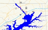
Maryland Route 222 (MD 222) is a state highway
in the U.S. state
of Maryland
. The state highway runs 11.36 miles (18.3 km) from MD 7
in Perryville
north to U.S. Route 1
(US 1) near Conowingo
. MD 222 parallels the Susquehanna River
in western Cecil County
, connecting Perryville and Conowingo with Port Deposit
. Due to limitations in the highway in Port Deposit, including a steep hill and a low railroad bridge, the state highway has a truck bypass that uses MD 275
, MD 276
, and US 1 through Woodlawn and Rising Sun
to connect Interstate 95
(I-95) with US 222 in Conowingo.
MD 222 was originally constructed as MD 268, a number presently assigned to North Street
in Elkton
. The state highway was paved from Perryville to Port Deposit in the late 1910s and early 1920s. MD 268 was extended north to Conowingo in the early 1930s. In 1938, MD 268 was superseded when US 222 was extended south from US 1 in Conowingo to US 40
in Perryville. The only significant change as US 222 occurred when a new alignment was constructed around the interchange with I-95 in the early 1960s. MD 222 was designated in 1995 when US 222 was rolled back to its former and present terminus at US 1 in Conowingo.
. The disconnected old alignment continues straight as Aiken Avenue Extended while MD 222 heads northeast as Perryville Road to cross over CSX
's Philadelphia Subdivision. The state highway curves north and receives the other end of the old alignment, Clayton Street, before leaving the town of Perryville and passing Perryville High School
. MD 222 intersects the southern end of MD 824
(Blythedale Road) and the entrance to Prime Outlets Perryville before meeting I-95 (John F. Kennedy Memorial Highway) at a folded diamond interchange. The state highway passes the entrance to Hollywood Casino Perryville
before reaching an intersection with the northern end of MD 824 and MD 275 (Perrylawn Drive). MD 222 Truck follows MD 275 north toward Rising Sun, while MD 222 turns west onto Bainbridge Road toward Port Deposit.
MD 222 heads through a mix of forest and farmland, crossing Happy Valley Branch before passing the entrance to the former United States Naval Training Center, Bainbridge, which contains the Edward W. Haviland House
and the original campus of the Tome School
. The state highway then begins a steep descent from a high bluff to the Susquehanna River, with the southbound direction gaining a climbing lane. Upon entering the town limits of Port Deposit, MD 222's name changes to Main Street and the highway makes a sharp turn to the north to parallel the river and Norfolk Southern Railway
's Columbia & Port Deposit line. The state highway intersects MD 276 (Centre Street) in the center of Port Deposit. MD 222 passes the Paw Paw Building
and intersects Granite Avenue before crossing Rock Run and passing under a low railroad bridge to the west side of the tracks. The state highway leaves the town of Port Deposit and continues north as Susquehanna River Road, closely paralleling the river and passing through its forested flood plain, much of which is part of Susquehanna State Park
. Soon after crossing Octoraro Creek
, MD 222 reaches its northern terminus at an intersection with US 1 (Conowingo Road) at the eastern end of Conowingo Dam
. Following US 1 northeast to the community of Conowingo leads to the southern terminus of US 222 and the northern terminus of MD 222 Truck.
(now CSX) as a state-aid road by 1919. The highway was extended as a state road north from the B&O crossing to the top of the bluff above Port Deposit by 1921. Pavement was extended through Port Deposit to Rock Run in 1923. The final section of MD 268, Susquehanna River Road, was under construction by 1930 and completed by 1933. The highway reused an abandoned railroad bridge to cross Octoraro Creek.
The first change in alignment in MD 268 occurred around 1934 when a bridge was constructed over the B&O Railroad in Perryville, leaving behind Aiken Avenue Extended and Clayton Street. US 222 was extended south to US 40 in Perryville, then on Broad Street, in 1938, assuming all of MD 268. US 222 was reconstructed from US 40 to Port Deposit during World War II to improve access to the naval training center. In 1963, a new alignment was created for the interchange with I-95, bypassing Blythedale Road, which became MD 824. US 222's southern terminus was rolled back to US 1 in Conowingo in 1995; MD 222 was designated along its present course at the same time. MD 222 became the only signed state-numbered highway in Maryland with a number that matches a U.S. Highway
.
.
{| class=wikitable
!scope=col|Location
!scope=col|Mile
!scope=col|Destinations
!scope=col|Notes
|-
|rowspan=5|Perryville
|0.00
|
|Southern terminus
|-
|0.67
|
|
|-
|2.02
|
|
|-
|2.40
|
|I-95 Exit 93
|-
|2.85
|
|MD 222 turns west onto Bainbridge Road; southern terminus of MD 222 Truck, which heads north on MD 275
|-
|Port Deposit
|5.90
|
|
|-
|Conowingo
|11.36
|
|Northern terminus
(MDTA) and provide access to the authority's facilities around I-95's interchange with MD 222 and the John F. Kennedy Memorial Highway toll plaza to the east of the Millard E. Tydings Memorial Bridge
.
State highway
State highway, state road or state route can refer to one of three related concepts, two of them related to a state or provincial government in a country that is divided into states or provinces :#A...
in the U.S. state
U.S. state
A U.S. state is any one of the 50 federated states of the United States of America that share sovereignty with the federal government. Because of this shared sovereignty, an American is a citizen both of the federal entity and of his or her state of domicile. Four states use the official title of...
of Maryland
Maryland
Maryland is a U.S. state located in the Mid Atlantic region of the United States, bordering Virginia, West Virginia, and the District of Columbia to its south and west; Pennsylvania to its north; and Delaware to its east...
. The state highway runs 11.36 miles (18.3 km) from MD 7
Maryland Route 7
Maryland Route 7 is a collection of state highways in the U.S. state of Maryland. These highways are sections of old alignment of U.S. Route 40 between Baltimore and Elkton that were bypassed when US 40 was moved to Pulaski Highway, a four-lane divided highway, in the late 1930s and early 1940s...
in Perryville
Perryville, Maryland
Perryville is a town in Cecil County, Maryland, United States. The population was 3,672 at the 2000 census. The town is located off Interstate 95, on the north side of the mouth of the Susquehanna River.-History:...
north to U.S. Route 1
U.S. Route 1 in Maryland
U.S. Route 1 is the easternmost and longest of the major north–south routes of the United States Numbered Highway System, running from Key West, Florida to Fort Kent, Maine. In the U.S...
(US 1) near Conowingo
Conowingo, Maryland
Conowingo is a small community in western Cecil County, Maryland, USA.Conowingo is a Susquehannock word for "at the rapids".Conowingo was originally located on the eastern bank of the Susquehanna River at the confluence of the Conowingo Creek with the river...
. MD 222 parallels the Susquehanna River
Susquehanna River
The Susquehanna River is a river located in the northeastern United States. At long, it is the longest river on the American east coast that drains into the Atlantic Ocean, and with its watershed it is the 16th largest river in the United States, and the longest river in the continental United...
in western Cecil County
Cecil County, Maryland
Cecil County is a county located in the U.S. state of Maryland. It is part of the Delaware Valley. It was named for Cæcilius Calvert, 2nd Baron Baltimore , who was the first Proprietary Governor of the colony of Maryland from 1632 until his death in 1675. The county seat is Elkton. The newspaper...
, connecting Perryville and Conowingo with Port Deposit
Port Deposit, Maryland
Port Deposit is a town in Cecil County, Maryland, United States. It is located on the north bank of the Susquehanna River near its discharge into the Chesapeake Bay...
. Due to limitations in the highway in Port Deposit, including a steep hill and a low railroad bridge, the state highway has a truck bypass that uses MD 275
Maryland Route 275
Maryland Route 275 is a state highway in the U.S. state of Maryland. Known as Perrylawn Drive, the state highway runs from MD 222 and MD 824 in Perryville north to MD 276 in Woodlawn in western Cecil County. MD 275 provides an eastern bypass of Port Deposit and is signed as part of MD 222 Truck...
, MD 276
Maryland Route 276
Maryland Route 276 is a state highway in the U.S. state of Maryland. Known for most of its length as Jacob Tome Memorial Highway, the state highway runs from MD 222 in Port Deposit north to U.S. Route 1 near Rising Sun. MD 276 is named for Jacob Tome, a lumber magnate, state senator, and...
, and US 1 through Woodlawn and Rising Sun
Rising Sun, Maryland
Rising Sun is a town in Cecil County, Maryland, United States. The population was 1,702 at the 2000 census.-Overview:Rising Sun is located at ....
to connect Interstate 95
Interstate 95 in Maryland
Interstate 95 in Maryland is a major highway that runs diagonally from northeast to southwest, from Maryland's border with Delaware, to the Woodrow Wilson Bridge, briefly entering the District of Columbia before reaching Virginia...
(I-95) with US 222 in Conowingo.
MD 222 was originally constructed as MD 268, a number presently assigned to North Street
Maryland Route 268
Maryland Route 268 is a state highway in the U.S. state of Maryland. Known as North Street, the state highway runs from MD 7 north to MD 279 within Elkton. MD 268, the old alignment of MD 279 within Elkton, was designated in 1967 after MD 279 bypassed Elkton.-Route description:MD 268 begins an...
in Elkton
Elkton, Maryland
The town of Elkton is the county seat of Cecil County, Maryland, United States. The population was 11,893 as of the 2000 census and 14,842 according to current July 2008 census estimates. It is the county seat of Cecil County...
. The state highway was paved from Perryville to Port Deposit in the late 1910s and early 1920s. MD 268 was extended north to Conowingo in the early 1930s. In 1938, MD 268 was superseded when US 222 was extended south from US 1 in Conowingo to US 40
U.S. Route 40 in Maryland
U.S. Route 40 in the U.S. state of Maryland runs from western Maryland to Cecil County in the state's northeastern corner. With a total length of over , it is the longest numbered highway in Maryland. Almost half of the road overlaps with Interstate 68 or Interstate 70, while the old alignment...
in Perryville. The only significant change as US 222 occurred when a new alignment was constructed around the interchange with I-95 in the early 1960s. MD 222 was designated in 1995 when US 222 was rolled back to its former and present terminus at US 1 in Conowingo.
Route description
MD 222 begins at an intersection with MD 7 (Broad Street) in downtown Perryville. The state highway heads north as two-lane Aiken Avenue to US 40 (Pulaski Highway) immediately to the east of the toll plaza for the Thomas J. Hatem Memorial BridgeThomas J. Hatem Memorial Bridge
The Thomas J. Hatem Memorial Bridge is a bridge carrying the traffic across the Susquehanna River on U.S. Route 40 between Havre de Grace and Perryville via Garrett Island in northeast Maryland. It is the oldest of the eight toll facilities operated and maintained by the Maryland Transportation...
. The disconnected old alignment continues straight as Aiken Avenue Extended while MD 222 heads northeast as Perryville Road to cross over CSX
CSX Transportation
CSX Transportation operates a Class I railroad in the United States known as the CSX Railroad. It is the main subsidiary of the CSX Corporation. The company is headquartered in Jacksonville, Florida, and owns approximately 21,000 route miles...
's Philadelphia Subdivision. The state highway curves north and receives the other end of the old alignment, Clayton Street, before leaving the town of Perryville and passing Perryville High School
Perryville High School
Perryville High School is a public secondary school in Perryville, Maryland. The school is operated by Cecil County Public Schools.-Clubs:*Academic Team*Art Honor Society*Best Buddies*Book Club*Chess*Checkers Club*Community Living*Concert Band...
. MD 222 intersects the southern end of MD 824
Maryland Route 824
Maryland Route 824 is a state highway in the U.S. state of Maryland. Known as Blythedale Road, the state highway runs from MD 222 north to MD 222 and MD 275 within Perryville in southwestern Cecil County. MD 824 is the old alignment of U.S. Route 222, which is now MD 222 in Perryville...
(Blythedale Road) and the entrance to Prime Outlets Perryville before meeting I-95 (John F. Kennedy Memorial Highway) at a folded diamond interchange. The state highway passes the entrance to Hollywood Casino Perryville
Hollywood Casino Perryville
Hollywood Casino Perryville, Maryland's first casino, is in Perryville. It is owned by Penn National Gaming; the casino opened on September 30, 2010. It has a gaming floor of , with over 1,500 slot machines....
before reaching an intersection with the northern end of MD 824 and MD 275 (Perrylawn Drive). MD 222 Truck follows MD 275 north toward Rising Sun, while MD 222 turns west onto Bainbridge Road toward Port Deposit.
MD 222 heads through a mix of forest and farmland, crossing Happy Valley Branch before passing the entrance to the former United States Naval Training Center, Bainbridge, which contains the Edward W. Haviland House
Edward W. Haviland House
The Edward W. Haviland House is a historic home located at Port Deposit, Cecil County, Maryland, United States. It is a -story, 12-room, stuccoed frame building constructed in 1913 in the Dutch Colonial style. In 1926, a large frame double garage and carriage house was built to the rear of the main...
and the original campus of the Tome School
Tome School
The Tome School is a private school located in North East in Cecil County in Maryland, USA and is one of the oldest schools in the state of Maryland.-Port Deposit:...
. The state highway then begins a steep descent from a high bluff to the Susquehanna River, with the southbound direction gaining a climbing lane. Upon entering the town limits of Port Deposit, MD 222's name changes to Main Street and the highway makes a sharp turn to the north to parallel the river and Norfolk Southern Railway
Norfolk Southern Railway
The Norfolk Southern Railway is a Class I railroad in the United States, owned by the Norfolk Southern Corporation. With headquarters in Norfolk, Virginia, the company operates 21,500 route miles in 22 eastern states, the District of Columbia and the province of Ontario, Canada...
's Columbia & Port Deposit line. The state highway intersects MD 276 (Centre Street) in the center of Port Deposit. MD 222 passes the Paw Paw Building
Paw Paw Building
Paw Paw Building, also known as Odd Fellows Hall, is a historic building located at Port Deposit, Cecil County, Maryland. It is a two story, 36 feet by 40 feet, stone structure covered with plaster, that was built in 1821 by the First Methodist Episcopal congregation. It was used as a church until...
and intersects Granite Avenue before crossing Rock Run and passing under a low railroad bridge to the west side of the tracks. The state highway leaves the town of Port Deposit and continues north as Susquehanna River Road, closely paralleling the river and passing through its forested flood plain, much of which is part of Susquehanna State Park
Susquehanna State Park (Maryland)
Susquehanna State Park is a state park on the lower Susquehanna River north of Havre de Grace, Maryland. The main park area is on the west bank of the river, but it also manages land on the river islands and east bank....
. Soon after crossing Octoraro Creek
Octoraro Creek
Octoraro Creek is a tributary of the Susquehanna River, joining it above the Susquehanna's mouth at Chesapeake Bay. The Octoraro rises as an East and West Branch in Pennsylvania. The East Branch and Octoraro Creek form the southern half of the border between Lancaster and Chester counties until...
, MD 222 reaches its northern terminus at an intersection with US 1 (Conowingo Road) at the eastern end of Conowingo Dam
Conowingo Dam
The Conowingo Dam is a large hydroelectric dam in the Lower Susquehanna River. The dam, one of the largest non-federal hydroelectric dams in the US, is classified as a medium height, masonry gravity type dam...
. Following US 1 northeast to the community of Conowingo leads to the southern terminus of US 222 and the northern terminus of MD 222 Truck.
History
What is now MD 222 was originally designated MD 268. The first paved section of MD 268 was Aiken Avenue from Broad Street north to around present-day US 40 in Perryville, which was surfaced by 1910. Aiken Avenue was extended north to the Baltimore and Ohio RailroadBaltimore and Ohio Railroad
The Baltimore and Ohio Railroad was one of the oldest railroads in the United States and the first common carrier railroad. It came into being mostly because the city of Baltimore wanted to compete with the newly constructed Erie Canal and another canal being proposed by Pennsylvania, which...
(now CSX) as a state-aid road by 1919. The highway was extended as a state road north from the B&O crossing to the top of the bluff above Port Deposit by 1921. Pavement was extended through Port Deposit to Rock Run in 1923. The final section of MD 268, Susquehanna River Road, was under construction by 1930 and completed by 1933. The highway reused an abandoned railroad bridge to cross Octoraro Creek.
The first change in alignment in MD 268 occurred around 1934 when a bridge was constructed over the B&O Railroad in Perryville, leaving behind Aiken Avenue Extended and Clayton Street. US 222 was extended south to US 40 in Perryville, then on Broad Street, in 1938, assuming all of MD 268. US 222 was reconstructed from US 40 to Port Deposit during World War II to improve access to the naval training center. In 1963, a new alignment was created for the interchange with I-95, bypassing Blythedale Road, which became MD 824. US 222's southern terminus was rolled back to US 1 in Conowingo in 1995; MD 222 was designated along its present course at the same time. MD 222 became the only signed state-numbered highway in Maryland with a number that matches a U.S. Highway
United States Numbered Highways
The system of United States Numbered Highways is an integrated system of roads and highways in the United States numbered within a nationwide grid...
.
Junction list
The entire route is in Cecil CountyCecil County, Maryland
Cecil County is a county located in the U.S. state of Maryland. It is part of the Delaware Valley. It was named for Cæcilius Calvert, 2nd Baron Baltimore , who was the first Proprietary Governor of the colony of Maryland from 1632 until his death in 1675. The county seat is Elkton. The newspaper...
.
{| class=wikitable
!scope=col|Location
!scope=col|Mile
!scope=col|Destinations
!scope=col|Notes
|-
|rowspan=5|Perryville
Perryville, Maryland
Perryville is a town in Cecil County, Maryland, United States. The population was 3,672 at the 2000 census. The town is located off Interstate 95, on the north side of the mouth of the Susquehanna River.-History:...
|0.00
|
|Southern terminus
|-
|0.67
|
|
|-
|2.02
|
|
|-
|2.40
|
|I-95 Exit 93
|-
|2.85
|
|MD 222 turns west onto Bainbridge Road; southern terminus of MD 222 Truck, which heads north on MD 275
|-
|Port Deposit
Port Deposit, Maryland
Port Deposit is a town in Cecil County, Maryland, United States. It is located on the north bank of the Susquehanna River near its discharge into the Chesapeake Bay...
|5.90
|
|
|-
|Conowingo
Conowingo, Maryland
Conowingo is a small community in western Cecil County, Maryland, USA.Conowingo is a Susquehannock word for "at the rapids".Conowingo was originally located on the eastern bank of the Susquehanna River at the confluence of the Conowingo Creek with the river...
|11.36
|
|Northern terminus
Truck route
Maryland Route 222 Truck is a signed 12.49 miles (20.1 km) truck bypass of MD 222 from MD 222 in Perryville to US 1 and US 222 in Conowingo. The signed route follows MD 275 from MD 222 in Perryville north to MD 276 in Woodlawn. MD 222 Truck continues north on MD 276 from Woodlawn north to US 1 west of Rising Sun. The truck route then heads west on US 1 (in a wrong-way concurrency) to US 222's southern terminus in Conowingo. MD 222 Truck has existed since at least 2002.Auxiliary routes
MD 222 has three auxiliary routes that are maintained by the Maryland Transportation AuthorityMaryland Transportation Authority
The Maryland Transportation Authority is an independent state agency responsible for financing, constructing, operating, and maintaining eight toll facilities, currently consisting of two toll roads, two tunnels, and four bridges in Maryland...
(MDTA) and provide access to the authority's facilities around I-95's interchange with MD 222 and the John F. Kennedy Memorial Highway toll plaza to the east of the Millard E. Tydings Memorial Bridge
Millard E. Tydings Memorial Bridge
The Millard E. Tydings Memorial Bridge is located on the John F. Kennedy Memorial Highway in Maryland and carries Interstate 95 over the Susquehanna River between Cecil County and Harford County. Its annual traffic is 29 million vehicles....
.
- MD 222A is the designation for Chesapeake Overlook Parkway, a 0.09 mile (0.1448406 km) spur west from the intersection of MD 222 and the ramps to and from southbound I-95. This spur intersects MD 222B near its western end and serves as the entrance to Hollywood Casino Perryville.
- MD 222B is the designation for Turnpike Drive, a 0.89 miles (1.4 km) service road that heads south from MD 222A and veers west to parallel the southbound lanes of I-95. The state highway provides access to the MDTA administration building, the Perryville barracks of the Maryland State PoliceMaryland State PoliceThe Maryland State Police is the official state police force of the state of Maryland. The Maryland State Police is headquartered at 1201 Reisterstown Road in the Pikesville CDP in unincorporated Baltimore County.-Organizational structure:...
, and the adjacent truck weigh stationWeigh stationA weigh station is a checkpoint along a highway to inspect vehicular weights. Usually, trucks and commercial vehicles are subject to the inspection....
on southbound I-95. - MD 222C is the designation for G.R. Dawson Drive, a 0.48 mile (0.7724832 km) service road that heads west from MD 222 and parallels the northbound lanes of I-95. The state highway provides access to a truck weigh station on northbound I-95.
External links
- MD 222 @ MDRoads.com
- US 222 @ MDRoads.com
- misc.transport.road post discussing southern terminus of US 222 in Perryville
- MD 222 Truck signed along MD 275, MD 276, and US 1