
Maryland Route 187
Encyclopedia
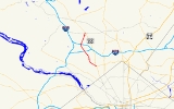
Maryland Route 187 is a state highway
in the U.S. state of Maryland
. Known as Old Georgetown Road, the state highway runs 5.32 miles (8.6 km) from MD 355
and MD 410
in Bethesda
north to MD 355 in North Bethesda
. MD 187 runs parallel to MD 355 through suburban areas of southern Montgomery County
.
in downtown Bethesda. The state highway heads northwest as a two-lane one-way street to Woodmont Avenue. Southbound MD 187 traffic is required to turn north or south onto Woodmont Avenue. Woodmont Avenue, which becomes a southbound one-way street at the intersection, leads to Montgomery Lane, which provides access to MD 355 and eastbound MD 410 (Montgomery Avenue). MD 187 heads northwest from Woodmont Avenue as a five-lane highway with center turn lane that passes through a five-way intersection with MD 188 (Wilson Lane), Arlington Road, and St. Elmo Avenue and leaves downtown Bethesda. The state highway veers north and becomes a six-lane divided highway at Suburban Hospital, which sits opposite the southern end of the NIH campus. MD 187 intersects several entrances to the federal campus and passes to the east of the tiny village of Oakmont
.
MD 187 enters North Bethesda at its diamond interchange
with Interstate 495 (Capital Beltway)
(I-495). The state highway intersects Democracy Boulevard, a county highway that heads west past Walter Johnson High School
and the Montgomery Mall
, and meets I-270
(Eisenhower Memorial Highway) at a diamond interchange whose ramps also connect with Rockledge Boulevard. MD 187 heads northeast to its intersection with Executive Boulevard, where the state highway curves to the east and reaches its northern terminus at MD 355 (Rockville Pike) just north of the White Flint Metro station.
.
{|class=wikitable
!Location
!Mile
!Destinations
!Notes
|-
|rowspan=4|Bethesda
|0.00
|
|Southern terminus; MD 187 begins one-way northbound
|-
|0.17
|Woodmont Avenue to
|Southbound direction of MD 187 ends; southbound traffic must turn onto Woodmont Avenue
|-
|0.31
|
|
|-
|2.64
|
|I-495 Exit 36
|-
|rowspan=2|North Bethesda
|3.76
|
|I-270 Exit 1
|-
|5.32
|
|Northern terminus
State highway
State highway, state road or state route can refer to one of three related concepts, two of them related to a state or provincial government in a country that is divided into states or provinces :#A...
in the U.S. state of Maryland
Maryland
Maryland is a U.S. state located in the Mid Atlantic region of the United States, bordering Virginia, West Virginia, and the District of Columbia to its south and west; Pennsylvania to its north; and Delaware to its east...
. Known as Old Georgetown Road, the state highway runs 5.32 miles (8.6 km) from MD 355
Maryland Route 355
Maryland Route 355 is a north–south road in western central Maryland in the United States. The southern terminus of the route is at the Washington, D.C. border in Friendship Heights, Montgomery County, where it continues south as Wisconsin Avenue into Washington. The northern terminus is...
and MD 410
Maryland Route 410
Maryland Route 410 is a state highway in the U.S. state of Maryland. Known for most of its length as East–West Highway, the highway runs from MD 355 in Bethesda east to Pennsy Drive in Landover Hills...
in Bethesda
Bethesda, Maryland
Bethesda is a census designated place in southern Montgomery County, Maryland, United States, just northwest of Washington, D.C. It takes its name from a local church, the Bethesda Meeting House , which in turn took its name from Jerusalem's Pool of Bethesda...
north to MD 355 in North Bethesda
North Bethesda, Maryland
North Bethesda is a census-designated place and an unincorporated area in Montgomery County, Maryland, United States. It borders the city of Rockville, and is closely associated with the city.-Geography:...
. MD 187 runs parallel to MD 355 through suburban areas of southern Montgomery County
Montgomery County, Maryland
Montgomery County is a county in the U.S. state of Maryland, situated just to the north of Washington, D.C., and southwest of the city of Baltimore. It is one of the most affluent counties in the United States, and has the highest percentage of residents over 25 years of age who hold post-graduate...
.
Route description
MD 187 begins at an intersection with MD 355 (Wisconsin Avenue) and westbound MD 410 (East–West Highway) next to the Bethesda station of the Washington MetroWashington Metro
The Washington Metro, commonly called Metro, and unofficially Metrorail, is the rapid transit system in Washington, D.C., United States, and its surrounding suburbs. It is administered by the Washington Metropolitan Area Transit Authority , which also operates Metrobus service under the Metro name...
in downtown Bethesda. The state highway heads northwest as a two-lane one-way street to Woodmont Avenue. Southbound MD 187 traffic is required to turn north or south onto Woodmont Avenue. Woodmont Avenue, which becomes a southbound one-way street at the intersection, leads to Montgomery Lane, which provides access to MD 355 and eastbound MD 410 (Montgomery Avenue). MD 187 heads northwest from Woodmont Avenue as a five-lane highway with center turn lane that passes through a five-way intersection with MD 188 (Wilson Lane), Arlington Road, and St. Elmo Avenue and leaves downtown Bethesda. The state highway veers north and becomes a six-lane divided highway at Suburban Hospital, which sits opposite the southern end of the NIH campus. MD 187 intersects several entrances to the federal campus and passes to the east of the tiny village of Oakmont
Oakmont, Maryland
Oakmont, Maryland is a village and special taxing district in Montgomery County, Maryland. Chartered in 1918, the village includes both sides of Oak Place and the south side of Oakmont Avenue, across Old Georgetown Road from the National Institutes of Health, in the Bethesda, Maryland postal area....
.
MD 187 enters North Bethesda at its diamond interchange
Diamond interchange
A diamond interchange is a common type of road junction, used where a freeway crosses a minor road. The freeway itself is grade-separated from the minor road, one crossing the other over a bridge...
with Interstate 495 (Capital Beltway)
Interstate 495 (Capital Beltway)
Interstate 495 is a Interstate Highway that surrounds the United States' capital of Washington, D.C., and its inner suburbs in adjacent Maryland and Virginia. I-495 is widely known as the Capital Beltway or simply the Beltway, especially when the context of Washington, D.C., is clear...
(I-495). The state highway intersects Democracy Boulevard, a county highway that heads west past Walter Johnson High School
Walter Johnson High School
Walter Johnson High School is located at 6400 Rock Spring Drive in Bethesda, an unincorporated region of Montgomery County, Maryland.WJHS serves areas in Bethesda and Rockville, as well as the towns of Garrett Park and Kensington.-History:...
and the Montgomery Mall
Westfield Montgomery
Westfield Montgomery is an upscale shopping complex in Bethesda, Maryland, on Democracy Boulevard near Interstate 270 and the Capital Beltway .-History:...
, and meets I-270
Interstate 270 (Maryland)
Interstate 270 is a auxiliary Interstate Highway in the U.S. state of Maryland that travels between Interstate 495 just north of Bethesda, Montgomery County and Interstate 70 in the city of Frederick in Frederick County. It consists of the mainline as well as a spur that provides access to and...
(Eisenhower Memorial Highway) at a diamond interchange whose ramps also connect with Rockledge Boulevard. MD 187 heads northeast to its intersection with Executive Boulevard, where the state highway curves to the east and reaches its northern terminus at MD 355 (Rockville Pike) just north of the White Flint Metro station.
Junction list
The entire route is in Montgomery CountyMontgomery County, Maryland
Montgomery County is a county in the U.S. state of Maryland, situated just to the north of Washington, D.C., and southwest of the city of Baltimore. It is one of the most affluent counties in the United States, and has the highest percentage of residents over 25 years of age who hold post-graduate...
.
{|class=wikitable
!Location
!Mile
!Destinations
!Notes
|-
|rowspan=4|Bethesda
Bethesda, Maryland
Bethesda is a census designated place in southern Montgomery County, Maryland, United States, just northwest of Washington, D.C. It takes its name from a local church, the Bethesda Meeting House , which in turn took its name from Jerusalem's Pool of Bethesda...
|0.00
|
|Southern terminus; MD 187 begins one-way northbound
|-
|0.17
|Woodmont Avenue to
|Southbound direction of MD 187 ends; southbound traffic must turn onto Woodmont Avenue
|-
|0.31
|
|
|-
|2.64
|
|I-495 Exit 36
|-
|rowspan=2|North Bethesda
North Bethesda, Maryland
North Bethesda is a census-designated place and an unincorporated area in Montgomery County, Maryland, United States. It borders the city of Rockville, and is closely associated with the city.-Geography:...
|3.76
|
|I-270 Exit 1
|-
|5.32
|
|Northern terminus